Dangerous Ice Storm Likely This Weekend With Widespread Power Outages Across Parts of Southern Ontario
/
NOTE: YOU CAN CLICK ON THE MAP TO OPEN A ZOOMABLE IMAGE
Concern is rapidly growing for what is shaping up to be a potentially devastating ice storm this weekend across parts of Central and Eastern Ontario. Prolonged freezing rain, beginning Friday evening, is expected to persist throughout much of the weekend, leading to substantial ice accretion on exposed surfaces.
This storm has the potential to reach ice accumulation levels not seen in years—or even over a decade. With up to 40mm of ice accretion possible, widespread power outages are likely in the hardest-hit regions, including Muskoka, Simcoe County, Kawartha Lakes, Peterborough, and Kingston.
Some of these power outages could last for days or even weeks, especially in more rural areas with dense tree coverage. Trees weighed down by ice are likely to fall, taking power lines with them. Travel conditions will also be significantly impacted, as ice-covered roads become extremely dangerous.
For Northern Ontario, the storm will start as a classic winter system, bringing heavy snowfall to Northeastern Ontario throughout Saturday. A second round of precipitation on Sunday could introduce freezing rain and ice pellets further south, affecting areas like Elliot Lake, Sudbury, and North Bay. Snowfall totals in Northeastern Ontario are expected to range from 20 to 30cm, making travel difficult.
Even the Ottawa Valley will see significant snowfall, with up to 20cm possible, along with a mix of ice pellets. By Sunday, freezing rain could become a concern for the region as temperatures rise and the precipitation type shifts.

PRECIPITATION TYPE - MAP FROM WEATHERBELL
As of Friday afternoon, rain is already moving into Southwestern Ontario. By the evening, precipitation will spread north and east into Central and Eastern Ontario.
Based on the latest data, a band of heavy snow is expected to develop along a corridor stretching from Sudbury through North Bay and into the Ottawa region. To the south, an area of freezing rain will form over the Bruce Peninsula and extend into regions around Lake Simcoe.

ESTIMATED TEMPERATURE - MAP FROM WEATHERBELL
How far south the freezing rain spreads remains uncertain. Model guidance suggests surface temperatures will hover near the freezing mark across Barrie and the Greater Toronto Area (GTA).
Even a fraction of a degree difference could significantly alter how much freezing rain accumulates. If the air remains colder than expected, freezing rain could be more widespread. However, a slightly warmer scenario would push the freezing rain line further north.
Confidence is highest for freezing rain in northern sections of Simcoe County, Kawartha Lakes, and Muskoka. These areas are most likely to remain below freezing for an extended period, allowing heavy ice accretion to build up.

PRECIPITATION TYPE - MAP FROM WEATHERBELL
The most intense icing is expected overnight into early Saturday morning. The worst conditions will stretch from Muskoka through Peterborough and into Kingston.
Once again, temperature will be the deciding factor. Some areas, such as Barrie and Newmarket, sit right on the edge between freezing rain and regular rain. If cold air lingers longer than anticipated, freezing rain could extend as far south as the northern GTA, as well as higher elevations like the Dundalk Highlands.

PRECIPITATION TYPE - MAP FROM WEATHERBELL
Through Saturday morning and afternoon, light to moderate freezing rain or drizzle is expected to persist across portions of Central Ontario, particularly around Lake Simcoe. However, the intensity will decrease compared to the earlier hours.
Further south, rain will continue across Southwestern Ontario and the GTA. This is when we expect the warmest temperatures of the storm. Some areas in Deep Southwestern Ontario, including Windsor, could surge into the 20s, while Central Ontario remains near or below freezing.

PRECIPITATION TYPE - MAP FROM WEATHERBELL
By Saturday evening, another round of heavy precipitation is expected to push into Central Ontario. At the same time, temperatures will steadily drop. Regions that saw rain in the afternoon—including parts of the GTA and Barrie—may transition back to freezing rain.

ESTIMATED TEMPERATURE - MAP FROM WEATHERBELL
Model data suggests that by late Saturday night into Sunday morning, the freezing rain line could shift southwest of the GTA. This could result in several hours of freezing rain across Kitchener, Waterloo, and parts of the Toronto area.
Deep Southwestern Ontario, including Windsor, Sarnia, and London, is expected to remain unaffected, staying well above freezing.
PRECIPITATION TYPE - MAP FROM WEATHERBELL
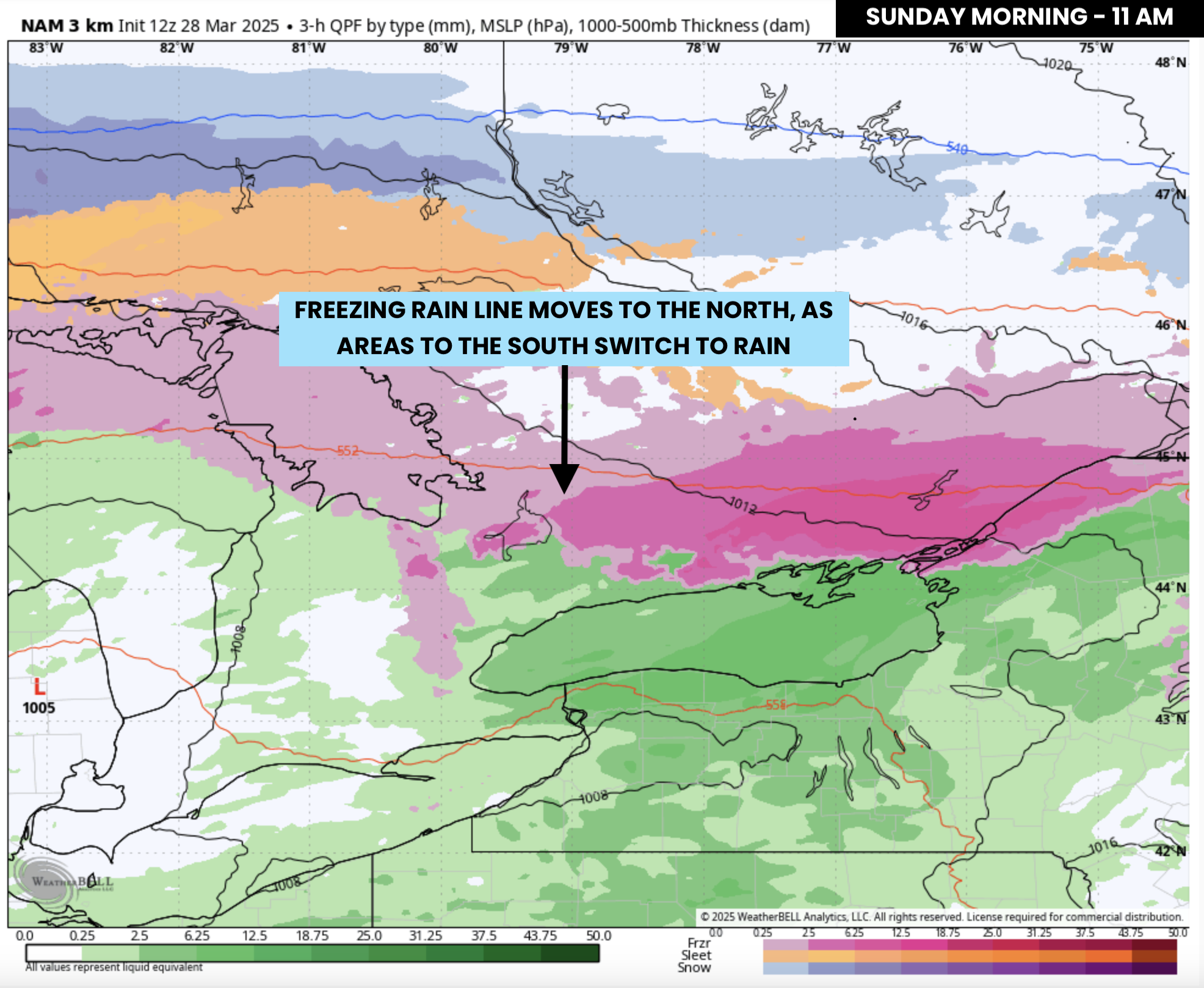
Sunday morning will bring a gradual transition from freezing rain to regular rain across the GTA as temperatures climb above freezing. However, elevated areas northwest of the city, such as Guelph, Orangeville, and Shelburne, could see freezing rain linger for a few extra hours.
For Central Ontario, the freezing rain will continue into early Sunday afternoon as the main area of precipitation slowly shifts north.
By Sunday afternoon, the Ottawa Valley may begin transitioning from snow to ice pellets and then to freezing rain as temperatures rise.

PRECIPITATION TYPE - MAP FROM WEATHERBELL
Most of Southern Ontario will warm above the freezing mark by late Sunday, finally pushing the freezing rain threat northward.
However, by Sunday night into Monday morning, the risk of freezing rain will shift to Northeastern Ontario, including Sudbury and North Bay.
Meanwhile, heavy snow and ice pellets will impact more northern regions, such as Wawa and Timmins.

NOTE: YOU CAN CLICK ON THE MAP TO OPEN A ZOOMABLE IMAGE
Predicting exact ice accretion remains challenging, as many factors influence how much ice actually builds up. The amount of freezing rain you experience may vary significantly from nearby areas due to microclimate effects, surface conditions, and temperature fluctuations.
Some high-resolution model runs suggest an extreme scenario with localized pockets of over 50mm—possibly even 75mm—of freezing rain. However, because much of this precipitation will fall in a relatively short timeframe, not all of it will necessarily adhere to surfaces.
Given this, we are forecasting general ice accretion between 25 and 40mm in the hardest-hit areas. This includes the northern tip of the Bruce Peninsula, Muskoka, Orillia, Barrie, Orangeville, Collingwood, Lindsay, Peterborough, Belleville, and Kingston.
If temperatures are slightly colder than expected, some locations could exceed 40mm of ice accretion, particularly where conditions allow for more efficient accumulation.

To put this into perspective, we can use the Sperry-Piltz Ice Accumulation Index (SPIA Index). With forecasted ice accumulations of 25-40mm (1-1.4”), this storm falls into a Category 4 ice event—even before factoring in wind.
While we are not expecting extreme winds, gusts of 40-50km/h (25-30 mph) in some areas could push this storm into Category 5 territory. According to the SPIA Index, a Category 5 ice storm results in:
Catastrophic damage to entire exposed utility systems, including both distribution and transmission networks. Outages could last several weeks in some areas. Shelters needed.
For the Greater Toronto Area (GTA), ice accretion amounts will vary significantly. The biggest factor will be how long cold air remains trapped at the surface.
We currently expect between 10-15mm of ice for northern parts of the GTA, including York, Durham, and Peel regions. Kitchener and Waterloo will likely see between 5-10mm.
Closer to the Lake Ontario shoreline—including downtown Toronto—freezing rain amounts should be lower, around 2-5mm. However, if temperatures are colder than expected, ice accretion in the GTA could be higher, so it’s still best to prepare.
To the north, ice accretion amounts will drop off as freezing rain transitions to ice pellets and snow closer to the Ottawa Valley.

NOTE: YOU CAN CLICK ON THE MAP TO OPEN A ZOOMABLE IMAGE
In terms of snowfall, widespread totals between 20-30cm are expected across much of Northeastern Ontario through Monday. This includes Sudbury, North Bay, Chapleau, Timmins, and Kirkland Lake. Even Thunder Bay could see 10-20cm of snow, mainly earlier in the weekend.
Along the Quebec border, snowfall amounts will range from 10-20cm in areas like the Ottawa Valley and Cornwall. Further southwest, freezing rain and ice pellets will be the dominant concern, leading to lower snowfall totals.
This storm remains highly dynamic, with small temperature fluctuations potentially making a massive difference in what type of precipitation falls. We will continue to monitor the latest data and provide updates as the situation evolves. Stay safe and stay prepared.


