Winter Isn’t Giving up Without a Fight in Parts of Ontario This Week
/
NOTE: YOU CAN CLICK ON THE MAP TO OPEN A ZOOMABLE IMAGE
Spring may have arrived on the calendar, but winter clearly didn’t get the memo! A late season storm is on the way to remind parts of Ontario that mother nature decides when we’re done with winter. This system will bringing hazardous travel conditions, accumulating snowfall, and blowing snow. Just when you thought it was safe to pack away the snow shovel, winter decides to throw another snowy tantrum to start off the week!
Sunday, March 23, 2025

NOTE: YOU CAN CLICK ON THE MAP TO OPEN A ZOOMABLE IMAGE
Location: North and west of Lake Superior
❄️ Hazard(s): Snow
📍 Location: North and west of Lake Superior
⏳ Timing: Sunday into Monday morning
⚠️ Impact(s): Hazardous travel conditions, reduced visibility, and possible road closures
✅ Confidence: High
📉 Impact: Moderate
A widespread snowfall event will bring accumulations of 15 to 25 cm north and west of Lake Superior. While confidence is high for at least 15 cm, higher terrain areas could see totals closer to 25 cm, though confidence in these higher amounts remains low.

NOTE: YOU CAN CLICK ON THE MAP TO OPEN A ZOOMABLE IMAGE
Location: Northwestern Ontario and north of Lake Superior
❄️ Hazard(s): Snow
📍 Location: Northwestern Ontario and north of Lake Superior
⏳ Timing: Sunday into Monday morning
⚠️ Impact(s): Difficult travel conditions
✅ Confidence: Moderate
📉 Impact: Moderate
Northwestern Ontario and areas northeast toward Lake Nipigon could see 5 to 15 cm of snow. The highest totals, near 10 to 15 cm, are expected close to the Minnesota border and northeastward.
Monday, March 24, 2025

NOTE: YOU CAN CLICK ON THE MAP TO OPEN A ZOOMABLE IMAGE
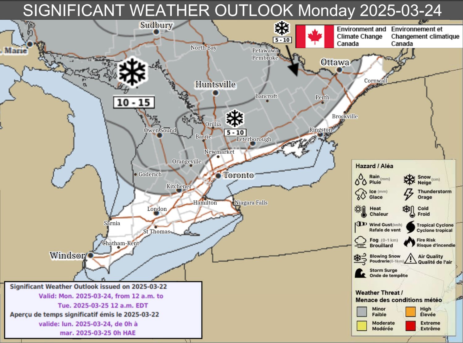
Location: Northeastern Ontario and parts of southern Ontario
❄️ Hazard(s): Snow
📍 Location: Northeastern Ontario and parts of southern Ontario
⏳ Timing: Monday
⚠️ Impact(s): Difficult travel conditions
✅ Confidence: Moderate
📉 Impact: Moderate
Snow will begin late Sunday night or early Monday morning, with accumulations of 5 to 15 cm expected. However, areas in southern Ontario could see snow transition to rain showers by late morning or early afternoon, creating slushy and messy road conditions. Later in the day, snow will redevelop east of Lake Huron and Georgian Bay.
There is some uncertainty regarding how far south the heavier snow will extend, as the system's track and timing of the changeover to rain remain uncertain.

NOTE: YOU CAN CLICK ON THE MAP TO OPEN A ZOOMABLE IMAGE
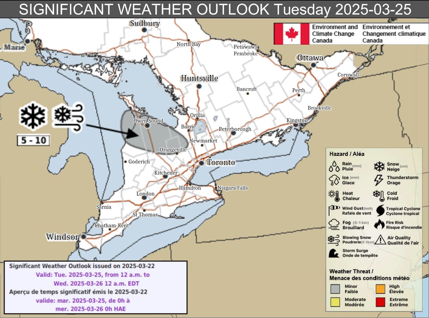
Tuesday, March 25, 2025
NOTE: YOU CAN CLICK ON THE MAP TO OPEN A ZOOMABLE IMAGE
Location: Areas east of northern Lake Huron
❄️ Hazard(s): Snow, Blowing Snow
📍 Location: Areas east of northern Lake Huron
⏳ Timing: Tuesday
⚠️ Impact(s): Difficult travel conditions
✅ Confidence: Moderate
📉 Impact: Moderate
Lake effect snow will develop early Tuesday morning, with 5 to 10 cm of snow expected. Gusty winds will create areas of blowing snow, leading to reduced visibility and hazardous travel conditions.

NOTE: YOU CAN CLICK ON THE MAP TO OPEN A ZOOMABLE IMAGE
Final Thoughts:
Winter may be running out of time, but it's making the most of its final days with multiple rounds of accumulating snow and travel impacts. The heaviest snowfall is expected north and west of Lake Superior, with lesser amounts across northwestern and northeastern Ontario. For southern Ontario, uncertainty remains regarding the transition from snow to rain, which could impact accumulation totals.
By Tuesday, lake effect snow and blowing snow east of northern Lake Huron could further worsen travel conditions. Those with travel plans should stay updated on forecasts and prepare for changing road conditions. While spring may be on the calendar, winter isn’t leaving without a fight.
Be safe, folks!
Disclaimer: These forecasts are issued by Environment Canada and typically published via their Twitter/X accounts. We receive these forecast via a daily email and often publish them to help inform our communities.


