Victoria Day to Bring Early Tease of Summer to Southern Ontario With 30°C Heat and Severe Storm Risk on Monday
/
NOTE: YOU CAN CLICK ON THE MAP TO OPEN A ZOOMABLE IMAGE
After a chilly and wet start to May across Southern Ontario, it finally looks like summer is ready to make an appearance, just in time for the Victoria Day long weekend.
The first half of the month has certainly felt more like an extension of early spring than the lead-up to summer. We’ve dealt with multiple rounds of widespread frost, temperatures consistently running below seasonal, and even reports of wet flurries in some areas.
While we did get a brief taste of severe weather with Canada’s first confirmed tornado of 2026 on May 9th near Lucan (northwest of London), the summer-like warmth has been hard to come by. That’s about to change!
The Victoria Day long weekend, often considered the “unofficial start of summer” in Ontario, is expected to fully live up to the title this year. A significant warm-up is set to spread across Southern Ontario through the weekend, peaking on Monday with widespread summer-like heat and humidity.
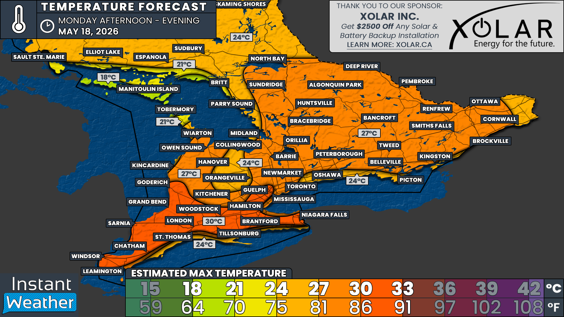
The hottest temperatures on Monday are expected to be found in Deep Southwestern Ontario extending into the western GTA and Niagara region, including Windsor, Chatham, Sarnia, London, Grand Bend, Woodstock, Brantford, Hamilton and Niagara Falls. Daytime highs in these areas are likely to range between 30-33°C with humidex values potentially approaching 35°C at times.
While many will be excited to finally enjoy some summer-like weather, it’s important to remember that the first major heat event of the season can be particularly stressful on the body. Be sure to stay hydrated, limit strenuous outdoor activity during the hottest part of the day, and never leave children or pets unattended in vehicles. Pets can also quickly overheat on hot pavement, so it’s a good idea to check surfaces before heading out for a walk.
For much of the rest of Southern Ontario, daytime highs are expected to range between 27-30°C, with the humidity making it feel into the low 30s. This includes Toronto, Kitchener, Barrie, Muskoka, Peterborough, Kingston and Ottawa.
The higher elevations of the Dundalk Highlands are likely to remain a few degrees cooler, with areas like Orangeville and Shelburne expected to top out closer to 24-27°C.
Meanwhile, temperatures directly along portions of the Lake Erie and Lake Ontario shoreline may stay noticeably cooler thanks to developing lake breezes. Southwest winds coming off the still-cool lake waters will help suppress temperatures near the shoreline through the afternoon hours.
As a result, locations such as Picton, Cobourg, Oshawa, Fort Erie, Port Colborne, Port Dover, Turkey Point and Leamington could struggle to climb much beyond the low 20s despite the intense heat further inland.
A similar cooling effect is expected along the Bruce Peninsula, Manitoulin Island and parts of the northern Georgian Bay shoreline. Locations such as Britt, Manitoulin Island and Tobermory are also expected to remain closer to 20°C.
The heat is expected to continue into Tuesday with similar daytime highs before a cold front sweeps through later in the week, returning temperatures closer to seasonal or even slightly below seasonal levels.
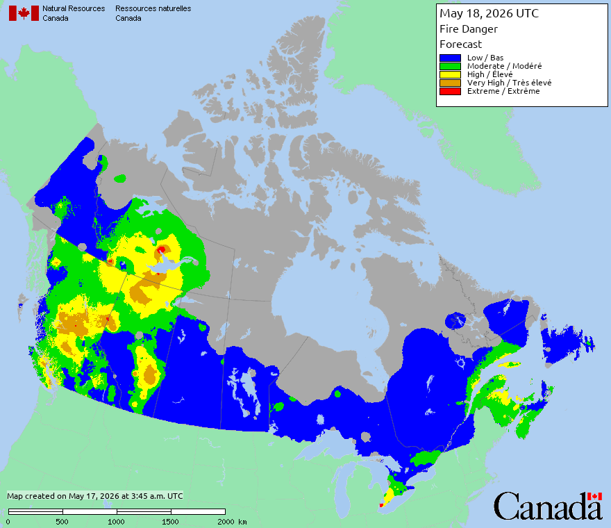
Another concern with the return of summer-like heat will be the increasing fire danger across parts of the province. According to the latest forecast from the Canadian Wildland Fire Information System, portions of Deep Southwestern Ontario could see fire danger levels reach high or even extreme on Monday, thanks to the combination of hot temperatures, dry conditions and gusty winds.
With many people planning campfires and fireworks for the Victoria Day long weekend, it’s especially important to use extra caution with any open flames. Be sure to follow all local burning regulations and fire bans, and check with your local municipality before setting off fireworks or lighting a fire. Under high or extreme fire danger conditions, even a small spark can quickly spread and become difficult to control.
NOTE: YOU CAN CLICK ON THE MAP TO OPEN A ZOOMABLE IMAGE

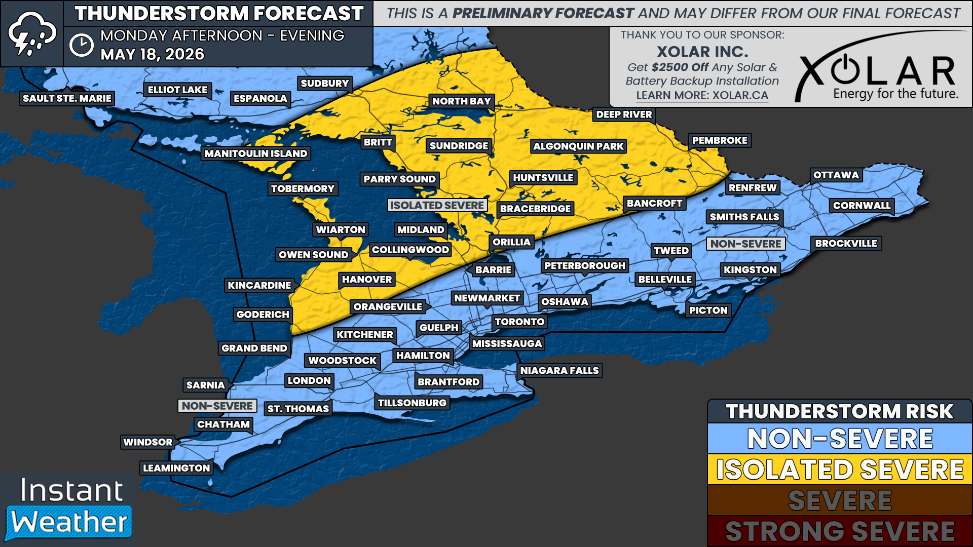
With the return of summer-like heat also comes the return of increasing atmospheric instability, which can help fuel thunderstorms. The next few days are expected to feature multiple opportunities for thunderstorms across parts of Southern Ontario.
The first round is expected Sunday night into Monday morning as a batch of non-severe nocturnal thunderstorms potentially tracks through areas near Lake Huron extending into Central and Eastern Ontario.
That activity may help set the stage for another round of storms later Monday afternoon and evening. At this point, the greatest risk for isolated severe thunderstorms appears to be focused east of Georgian Bay around Muskoka, Parry Sound and Algonquin Park. A line of storms may also develop over Michigan and track into Deep Southwestern Ontario later Monday night into Tuesday morning, but the exact intensity remains unclear by the time it reaches the border.
Locations that could potentially see isolated severe storms on Monday include Goderich, Kincardine, Hanover, Owen Sound, Wiarton, Tobermory, Collingwood, Midland, Orillia, Bracebridge, Huntsville, Parry Sound, Britt, North Bay, Sudbury, Algonquin Park, Bancroft, Pembroke and Deep River.
It remains too early to determine the exact storm mode and whether any tornado risk will develop. For now, all severe weather hazards remain possible including damaging wind gusts, large hail and torrential rainfall.
A more detailed severe weather outlook, including specific risk categories and hazard breakdowns, will be issued Sunday night or Monday morning once higher resolution forecast models come into range and confidence improves on the exact storm setup.
We’re also monitoring the potential for a more widespread severe thunderstorm risk on Tuesday as a cold front approaches the region later in the day.
However, there is still some uncertainty regarding the exact timing of the cold front. If it arrives later Tuesday afternoon or evening, there would likely be enough daytime heating available to support stronger storms. If the front arrives overnight or earlier in the day, it could significantly reduce instability and limit the severe weather potential.
At this point, isolated thunderstorms remain possible Tuesday afternoon and evening, but the exact location and intensity of the strongest storms remains uncertain.


