Saskatchewan & Manitoba: Strong Severe Thunderstorm Risk Saturday and Sunday
/
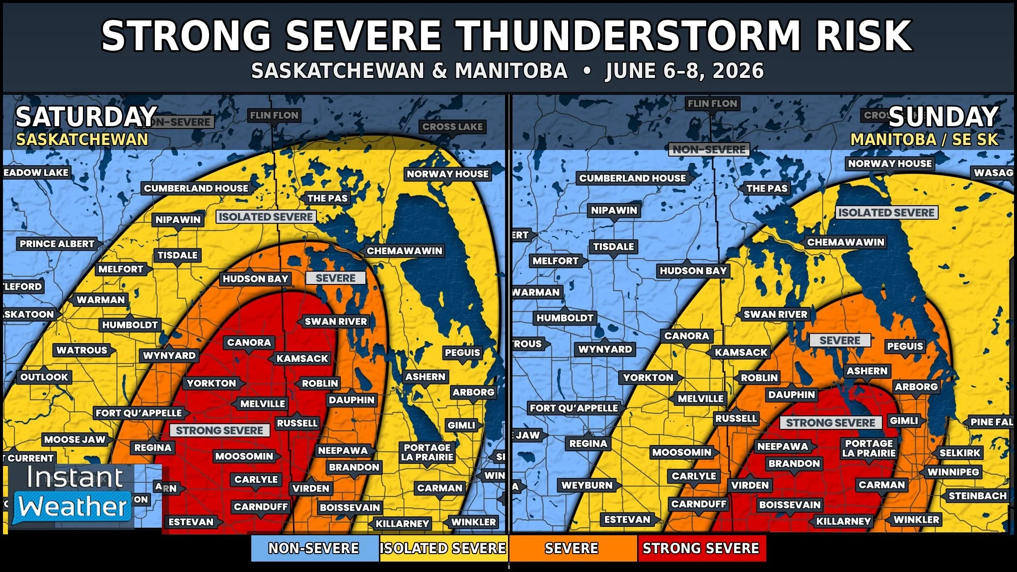
A multi-day severe thunderstorm risk is shaping up across parts of the Prairies this weekend, with the focus beginning in Saskatchewan on Saturday before shifting east into Manitoba and parts of far southeastern Saskatchewan on Sunday.
This is still a preliminary forecast and may differ from our final forecast, but there is enough concern at this point that residents across the risk zones should be paying close attention to the forecast through the weekend.
NOTE: you can click/tap to open a zoomable image
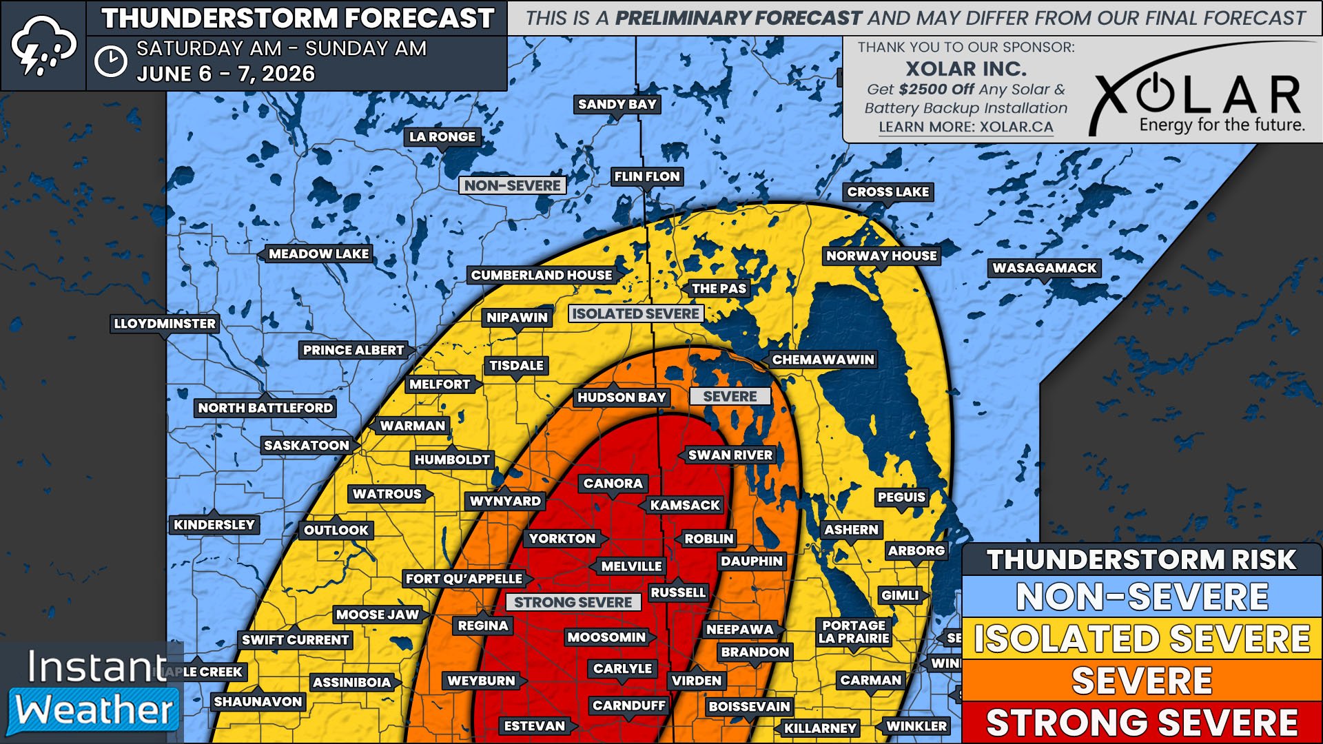
Saturday: Saskatchewan & Southwestern Manitoba
An isolated but strong severe thunderstorm risk will be in place across much of southern and central Saskatchewan from Saturday morning into Saturday night. Storms may be scattered at first, but any stronger cells that develop could produce large hail, strong wind gusts, frequent lightning, and heavy downpours.
The main concern develops later in the day, especially across southeastern Saskatchewan. By the late afternoon and evening, conditions may become more significant, with a higher-end severe threat possible around areas such as Regina, Fort Qu’Appelle, Yorkton, Melville, Moosomin, Weyburn, Estevan, Carlyle, and surrounding communities.
The primary hazards include very large hail, damaging winds, frequent lightning, torrential downpours, isolated flooding, and a tornado risk. This does not mean every community in the risk zone will see severe weather, but any storm that can fully develop may become severe or even strong severe in a hurry.
Additional thunderstorms may also move north from south of the border later Saturday evening and overnight, which could continue the severe risk into the nighttime hours across parts of southern and southeastern Saskatchewan. Please make sure you have a way to receive alerts before going to bed, especially if storms are still developing nearby or to the south.
NOTE: you can click/tap to open a zoomable image
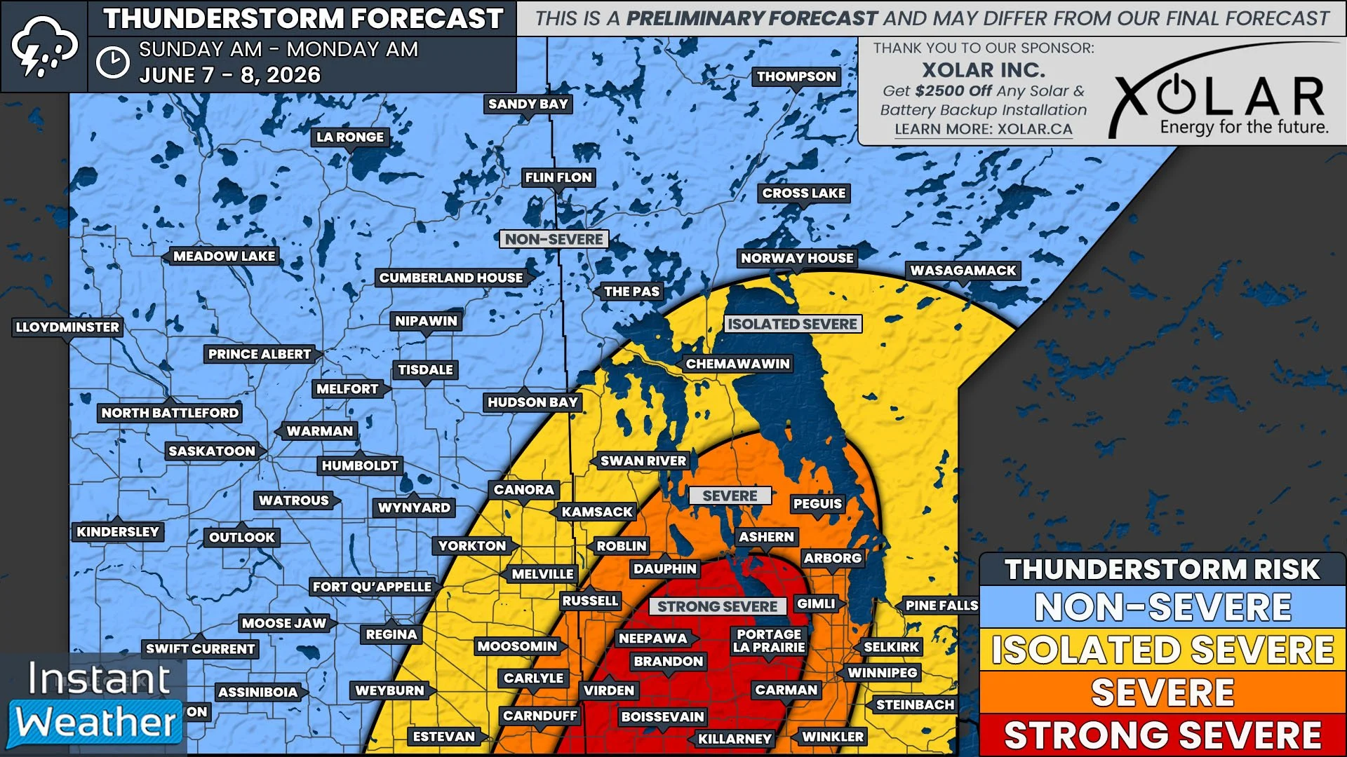
Sunday: Manitoba and Deep Southeastern Saskatchewan
By Sunday, the focus shifts farther east, with the strongest severe thunderstorm risk expected across southern and central Manitoba. The current risk area includes communities such as Brandon, Virden, Killarney, Boissevain, Neepawa, Dauphin, Portage la Prairie, Carman, Gimli, Selkirk, and surrounding areas.
Winnipeg and nearby communities are also included in the broader severe thunderstorm risk, although the highest risk may be somewhat west and northwest of the city based on the current outlook.
A strong severe risk is also possible across parts of far southeastern Saskatchewan, especially closer to the Manitoba border. This may include areas such as Moosomin, Carlyle, Estevan, Carnduff, and nearby communities, depending on how storms evolve through the day.
The strongest Sunday storms could bring very large hail, damaging wind gusts, torrential rainfall, frequent lightning, and a tornado risk. As with Saturday, the exact placement and timing of the highest risk may still change as newer data becomes available.
The bottom line: Saturday is the main day to watch across southern and southeastern Saskatchewan, while Sunday’s main concern shifts into Manitoba, with far southeastern Saskatchewan still needing to keep a close eye on the forecast.
Please stay weather-aware this weekend, review your severe weather plan, and be ready to take shelter quickly if watches or warnings are issued for your area.


