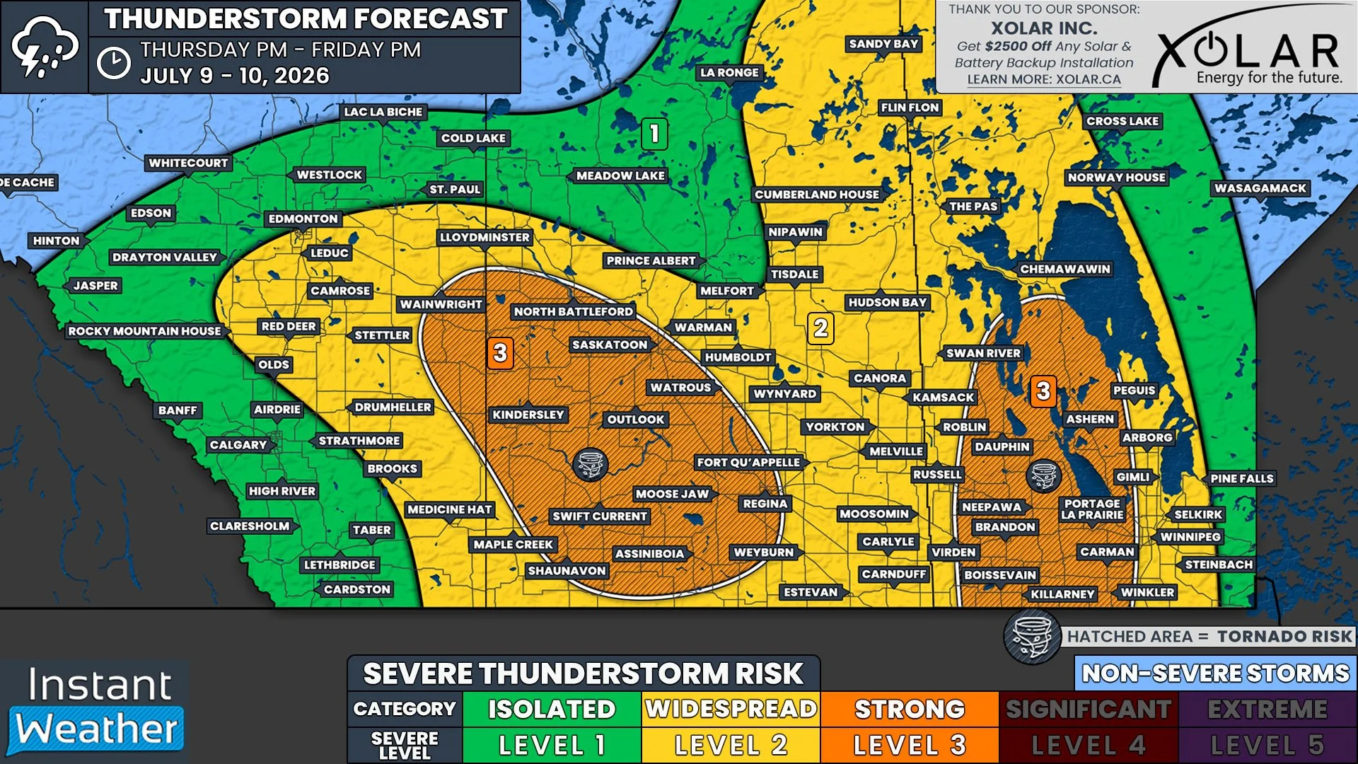
June Starts With a Bang as Strong Severe Thunderstorms Threaten Southern Manitoba
/
NOTE: YOU CAN CLICK ON THE MAP TO OPEN A ZOOMABLE IMAGE
The summer-like heat that has taken hold of the southern half of Manitoba over the last few days is finally going to give way to more seasonal temperatures. A cold front will move through the province today, which will be responsible for the drop in temperatures, however, it will also be the trigger for severe thunderstorms across Southern and Central Manitoba.
Thunderstorms have already developed this morning in Western North Dakota and they have been tracking north-northeastward across Westman. So far, these storms have stayed non-severe, but there is an isolate severe risk associated with them as they will continue making their way into the Parkland Region through the remainder of the morning and into the early afternoon. There is a more widespread severe risk associated with the storms just on the other side of the Saskatchewan border.
While this first wave of storms aren’t too strong, the thunderstorms that will follow this afternoon, on the other hand, could be a different story.
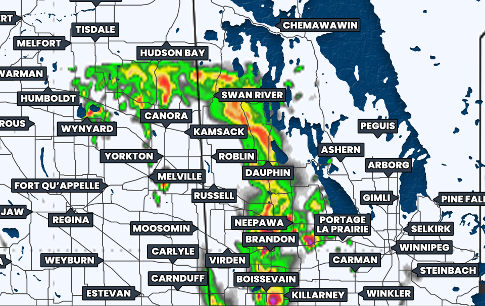
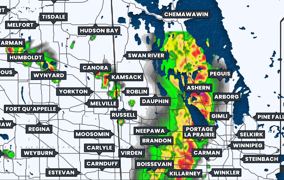
Simulated reflectivity at 3pm CT, courtesy of weatherbell.
The second round of thunderstorms will arrive in the early afternoon in Westman, around 12-1pm, as a combination of discrete cells and small multicellular storms. However, they will gradually organize into an intense line of thunderstorms, that will stretch across Southwestern Manitoba and Western North Dakota by the mid-afternoon.
This line is expected to comprised of strong severe thunderstorms, which could possibly be rotating supercells, that will track northeastward across Southern and Central Manitoba.
The mid-afternoon and into the early evening, from about 3-6pm, will be the time frame when there is the greatest risk for severe weather hazards. Large hail, up to the size of ping pong balls or golf balls, is one of the major threats during this time, along with heavy downpours and damaging wind gusts in excess of 100km/h and possibly as high as 130km/h. There is also the threat of an isolated tornado forming from these supercell storms.
Simulated reflectivity at 7pm CT, courtesy of weatherbell.
By the time the storms reach the Winnipeg area, at around 7-8pm, it’s expected that they will weaken slightly as they shift away from being supercellular and into a more linear storm mode. There will still be a widespread severe risk, with intense winds being of particular concern. Heavy downpours and slightly smaller hail will remain a risk as the bowing line continues towards the Ontario border, however the tornado threat all but disappears.
As we get later in the evening and into the overnight hours, the storms will lose energy and the severe risk will become more isolated. Weak thunderstorms will persist through the early morning hours throughout Eastman and into the Red River Valley, but they will dissipate to light showers by sunrise.
This is the kind of setup that will have a lot of eyes on it. We will definitely be streaming later so make sure to join us for our live coverage of these storms.