Storm of the Century for Tampa and Central Florida; Catastrophic Hurricane Milton Will Make Landfall Tonight
/
Satellite Image of Hurricane Milton from October 8th at 10:30PM EDT, Courtesy of Colorado State University.
Hurricane Milton managed to maintain its status as a Category 5 hurricane overnight and has since been downgraded to a still catastrophic Category 4. Milton has finally started to encounter some shear that began to change its structure and will cause the storm to weaken. The shear is expected to increase throughout the day, weakening the storm further, but it is still expected to be a powerful Category 3 hurricane upon landfall later tonight. Current projections have landfall occurring at around 1am with maximum sustained winds of 125 mph (201 km/h).
There have also been continued southward wobbles in Milton's track and this has pushed the potential landfall location further south. The margin of error is approximately 20 miles at this point, so the exact location of landfall is starting to become a bit clearer. Regardless of where the storm eventually makes landfall, the shear will cause the storm to grow and the devastating impacts will be widespread. This is the first hurricane to directly impact the Tampa area since 1921, making Hurricane Milton the storm of the century for the region.

Reflectivity from the Tampa Bay Radar Station on October 9th at 11:40AM EDT.
The eye of the hurricane is now visible on both Key West and Tampa Bay radars and we've already begun to see significant rainfall moving inland in Central Florida. Current rainfall totals for the Tampa area are in the 1-2 inch (25-50mm) range, but with the heaviest bands of rain just starting to come ashore, these numbers will jump.
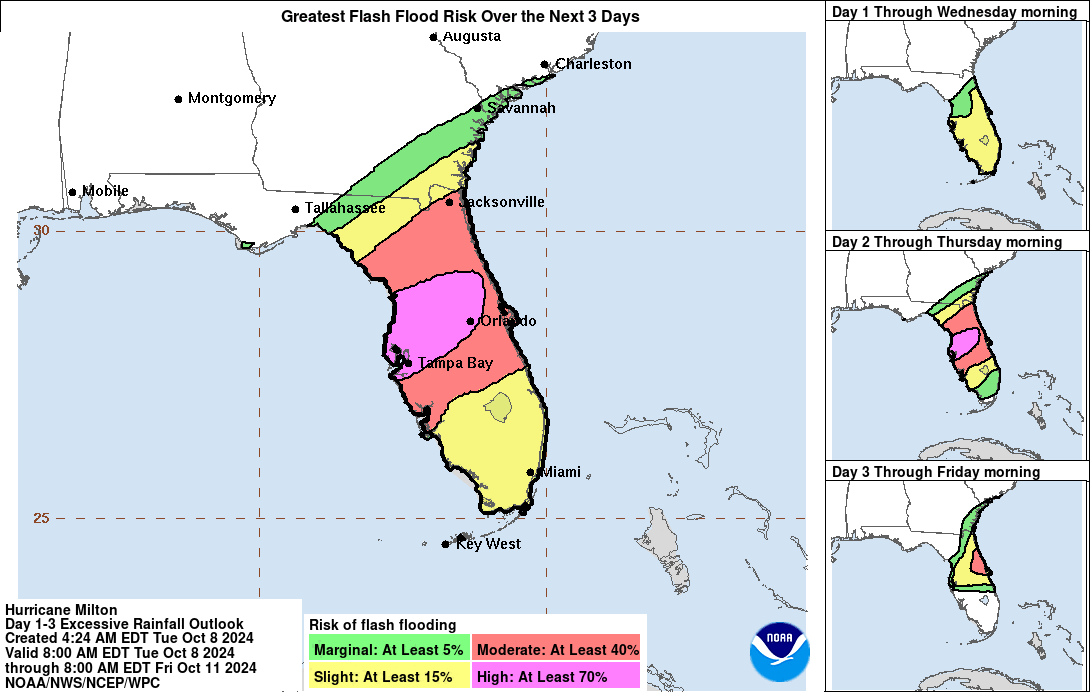
Widespread flooding remains a major concern across central and northern portions of the Florida Peninsula, with localized rainfall totals potentially reaching 18 inches (457 mm). These heavy rains will push far inland and elevate the risk of flash flooding over a large part of the state, especially in low-lying areas and along rivers. The Weather Prediction Center (WPC) continues to forecast a High Risk (their highest level) for flash flooding across a large swath of Central Florida that includes Tampa and Orlando.
We've also seen several tornado warnings and confirmed tornadoes south of Lake Okeechobee. Tornadoes are a major threat when hurricanes approach shore from the many imbedded thunderstorms and the potential for more tornadoes will continue into the afternoon and expanding northward with the overall motion of the hurricane.
Tropical storm-force winds are started to make their way over land with the rain this morning and they will gradually spread further inland throughout the day as the storm makes its final approach and the increased shear causes the wind field to grow. The area of hurricane-force winds will also become larger, but since they are found closer to the eye, they won’t be felt inland until closer to landfall.
The continued southern shift that's been seen in Hurricane Milton's track has also shifted where the greatest storm surge is expected. The greatest peak storm surge of 10-15ft is now forecasted along the coast from Anna Maria Island to Boca Grande. The forecast for Tampa Bay has been downgraded to 8-12ft, but this is still a life-threatening amount of water.
With a little over 12 hours until landfall, there is very little time left for those in the path to make their final preparations. If you or your loved ones are in the storm’s potential path, it’s crucial to stay informed, heed evacuation orders if they are issued, and follow any directives from local emergency personnel. We will continue to provide updates throughout the day as Milton makes its final approach.
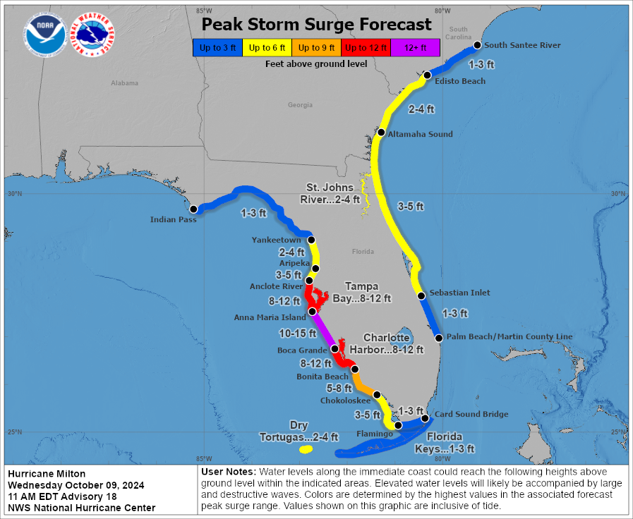
Peak Storm Surge Forecast in FLorida for Hurricane Milton, Courtesy of The National Hurricane Center.