
Strong Storm Takes Aim at Nova Scotia To Start Off the Week With Destructive Wind Gusts Over 100km/h and 30+mm of Rain Starting Sunday Evening
/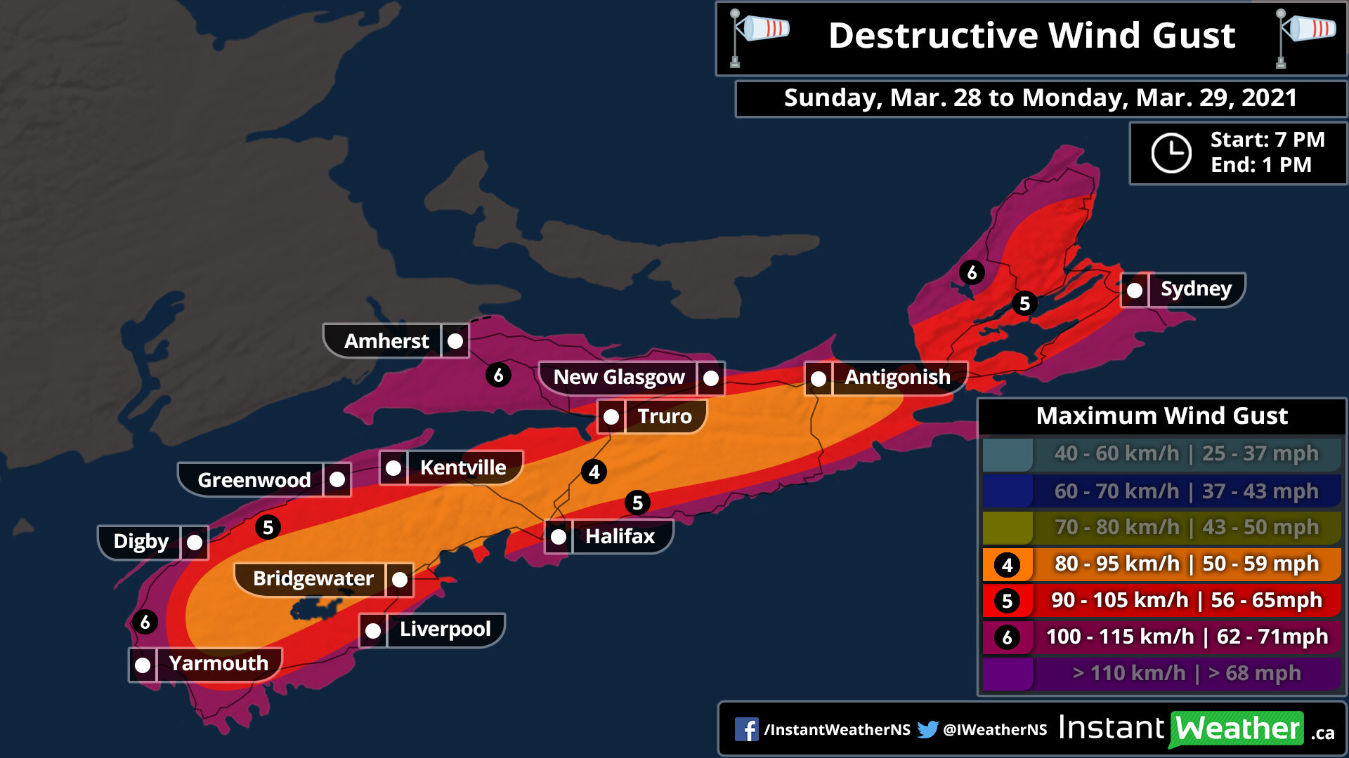
A very potent system is expected to move into Nova Scotia later Sunday bringing the threat of significant rainfall that may lead to some flooding and destructive wind gusts reaching up to 100-115km/h in the coastal parts of the province. The system is currently located over the Northeastern US and will move into the province sometime after the dinner hour starting with the extreme southern part of the province such as Yarmouth seeing the first effects and spreading northward through the province later in the evening.
Most of the rainfall that we’re expecting will come during the overnight hours and will be accompanied by damaging wind gusts which are expected to be the strongest during the early overnight. For Cape Breton, the temperature will be right near the freezing mark around midnight so we may see a few hours of wet snow or freezing rain before it switches over to rain as warmer air brings temperatures into the mid to upper single digits across Nova Scotia.
Rainfall will continue throughout the early part of Monday mainly during the morning hours. We’ll see it slowly taper off from west to east just after the noon hour. The strong winds are a similar story but will begin to weaken just after sunrise. All of the active weather should have exited the province by the late afternoon on Monday.
The strongest wind gusts from this storm will be found along the coast of Nova Scotia including Digby, Yarmouth, Halifax, Cape Breton and the northern part of the province near the New Brunswick border. This area could see maximum gusts between 100-115km/h particularly over the Greenwood/Kentville area which could see gust exceed 115km/h based on the latest data. We’ll see weaker wind gusts the further inland you get although all areas within the province should see gusts of at least 80km/h at some point during this storm. Significant wind damage is possible so be sure to secure anything that could be blown away and prepare for power outages across the province.

When it comes to the rainfall from this system, we’re looking at widespread totals between 20-40mm and maybe locally up to 50-60mm in some areas. The concern with this amount of rain is that it will come down within a short timeframe roughly around 12-16 hours so flooding could be a huge concerns in the hardest hit regions. The latest data suggests lower amounts for the north part of the province especially around the Greenwood/Kentville area which might struggle to even reach the 10mm mark from this storm.
We’ll continue to monitor this storm and keep you updated on any changes.
