Messy Winter Storm Takes Aim at Atlantic Canada This Weekend; Bringing Heavy Rain, Snow and Freezing Rain to Nova Scotia

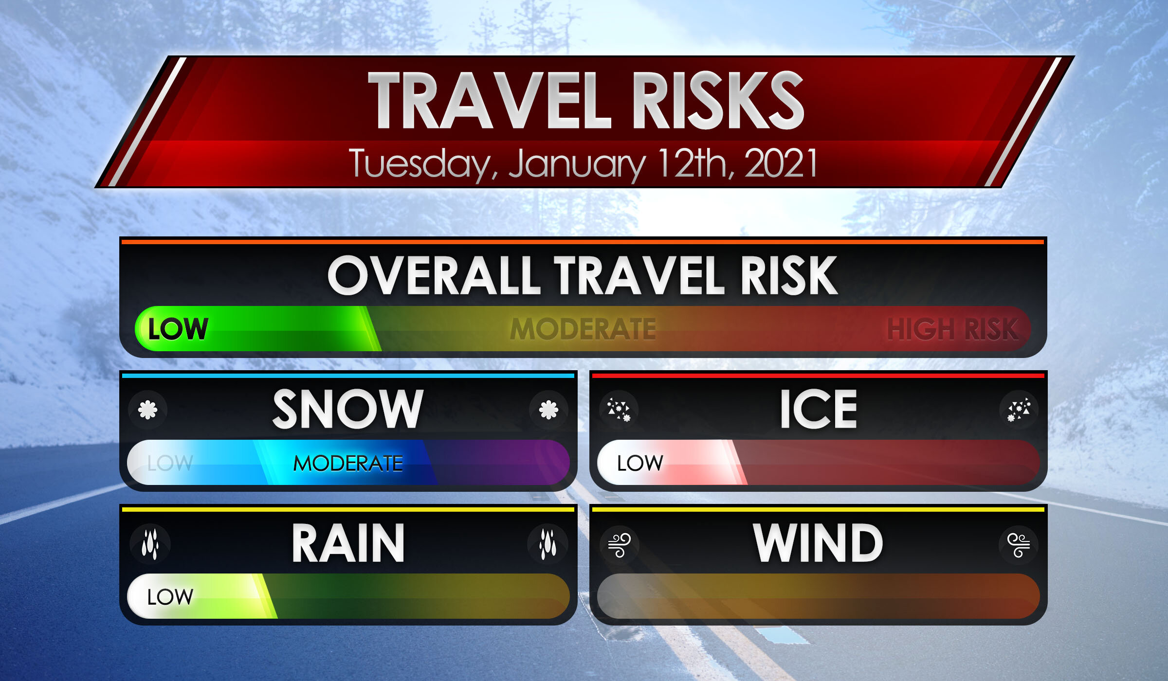
The next several days will be quite messy across Atlantic Canada with a major winter storm bringing rain, freezing rain, and snow to the region beginning tomorrow morning. For Nova Scotia, the big story from this storm will be widespread heavy rain with 30-50mm expected to fall over the next two days.

The storm will start off as snow, beginning in the early hours of Friday in Western Nova Scotia and spreading eastward throughout the morning. The snow will only last for a couple of hours before transitioning to heavy rain. Yarmouth and Shelburne will likely avoid having snow and will rather have rain right from the start of the storm. Overall snow accumulation will be minor across most of the province with up to 10cm expected to fall in Cumberland County the Cape Breton Highlands. Any snow will quickly melt with the following rain and double digit temperatures.

The steady rain will continue into the afternoon and we’re expecting a brief period of clearing before picking back up again in the evening lasting through to Saturday afternoon. Saturday morning is when we’re going to see the heaviest rain to start in the west and it will reach Cape Breton Island by early afternoon. After several hours of this heavy rain, things will begin to clear up in the late afternoon and early evening. Up to 50mm of rain will fall across Nova Scotia by Saturday evening and there could be higher amounts locally.

On Saturday afternoon, the temperatures will be hovering around 0° in Northern Nova Scotia and there is the threat of freezing rain. Untreated surfaces may become icy quite quickly so be cautious when travelling in the area.

The strongest winds from this storm will be felt with the heavy rain tomorrow afternoon. Along coastal areas, wind gusts will be in the 70-80 km/h range while further inland, expect 60-70 km/h. The exception will be Les Suêtes winds which may be up to 100 km/h and possibly higher.

A second round of precipitation will move in from the south overnight Saturday and may bring widespread freezing rain across the province on Sunday. We will provide further updates on that possibility on Saturday.

Strong Storm Takes Aim at Nova Scotia To Start Off the Week With Destructive Wind Gusts Over 100km/h and 30+mm of Rain Starting Sunday Evening

A very potent system is expected to move into Nova Scotia later Sunday bringing the threat of significant rainfall that may lead to some flooding and destructive wind gusts reaching up to 100-115km/h in the coastal parts of the province. The system is currently located over the Northeastern US and will move into the province sometime after the dinner hour starting with the extreme southern part of the province such as Yarmouth seeing the first effects and spreading northward through the province later in the evening.

Most of the rainfall that we’re expecting will come during the overnight hours and will be accompanied by damaging wind gusts which are expected to be the strongest during the early overnight. For Cape Breton, the temperature will be right near the freezing mark around midnight so we may see a few hours of wet snow or freezing rain before it switches over to rain as warmer air brings temperatures into the mid to upper single digits across Nova Scotia.

Rainfall will continue throughout the early part of Monday mainly during the morning hours. We’ll see it slowly taper off from west to east just after the noon hour. The strong winds are a similar story but will begin to weaken just after sunrise. All of the active weather should have exited the province by the late afternoon on Monday.

The strongest wind gusts from this storm will be found along the coast of Nova Scotia including Digby, Yarmouth, Halifax, Cape Breton and the northern part of the province near the New Brunswick border. This area could see maximum gusts between 100-115km/h particularly over the Greenwood/Kentville area which could see gust exceed 115km/h based on the latest data. We’ll see weaker wind gusts the further inland you get although all areas within the province should see gusts of at least 80km/h at some point during this storm. Significant wind damage is possible so be sure to secure anything that could be blown away and prepare for power outages across the province.

When it comes to the rainfall from this system, we’re looking at widespread totals between 20-40mm and maybe locally up to 50-60mm in some areas. The concern with this amount of rain is that it will come down within a short timeframe roughly around 12-16 hours so flooding could be a huge concerns in the hardest hit regions. The latest data suggests lower amounts for the north part of the province especially around the Greenwood/Kentville area which might struggle to even reach the 10mm mark from this storm.

We’ll continue to monitor this storm and keep you updated on any changes.

Messy Winter Storm With Prolonged Freezing Rain Risk To Impact Nova Scotia on Tuesday

The same storm that has brought record-breaking winter weather to much of the US is expected to also affect Nova Scotia throughout the day on Tuesday. The current track of the low-pressure system puts it right across the central part of the province so unlike the last storm which we were on the cold side, this one will be quite a mess starting off with some snow, ice pellets and freezing rain early Tuesday and transitioning over to rain as temperatures climb above the freezing mark.

The freezing rain risk is expected to be more prolonged further to the north and inland from the shoreline. Ice accretion could range from 6 -12mm in the hardest-hit regions which may result in hazardous driving conditions and localized power outages. Conditions will improve later in the day on Tuesday as all areas switch over to rain with temperatures into the mid to upper single digits by the evening.

The first bands of precipitation associated with this system will reach the southern part of the province just before sunrise on Tuesday. For the Yarmouth and Shelburne area, a few hours of freezing rain is possible before a switch over to rain later in the morning. Areas further to the north including Digby, Greenwood/Kentville and Halifax will see some light snow to start off the morning with some ice pellets and freezing rain mixing in during the late morning and heavier freezing rain for a few hours.

Northern Nova Scotia such as Amherst, Antigonish and Cape Breton could see a few hours of heavy snow during the morning - especially in the Amherst area may accumulate with up to 10cm of snow. They will transition over to the heavy freezing rain during the mid the late afternoon hours. This freezing rain may be quite intense and times with very poor conditions through the northern part of the province.

By the evening, it will feel like a whole different season as warmer temperatures take over across the province and putting an end to any of the wintery precipitation. Some parts of the southern part of the province may even flirt with the double digits during the early overnight hours. Rain will continue overnight will slowly tapering off as the system moves out over Newfoundland.

Accumulation from the morning snow will fairly insignificant considering it will be washed away by the rain, but wouldn’t be surprised to see up to 5-10cm around the Amherst area. The rest of Nova Scotia will see a few centimetres max. The main story of this system will be the potential prolonged freezing rain risk through the northern part of the province. Between 4-8 hours of persistent heavy freezing rain could lead to a fairly significant ice build-up through Amherst, Truro, New Glasgow and Western Cape Breton. Maximum ice accretion of between 6-12mm and maybe locally up to 15mm is expected in this region.

Other areas away from the shoreline could see a few hours of heavy freezing rain with around 2-6mm of ice accretion - this may include the Halifax Matro region, but they’re right on the line. Southern parts of the province will see minimal freezing rain with predominantly just heavy rainfall. Speaking of rain, totals between 10-25mm are possible with locally up to 35mm in the Yarmouth region. Between 5-15mm of rain is possible after all the freezing rain for the rest of the province.

Significant Freezing Rain Possible on Tuesday for Parts of Nova Scotia; Up to 10-15mm of Ice Accretion

A complex system currently bringing crippling winter weather to parts of the US Midwest including record-breaking snowfall to Oklahoma and Texas along with prolonged freezing rain through the Ohio Valley. This system will track up the East Coast bringing heavy snowfall to our friends in Ontario and New England. For Nova Scotia, the story will be a prolonged freezing rain threat on Tuesday.

This system will reach Nova Scotia overnight Monday starting with some light freezing drizzle across the southern part of the province. To the north, we will see mainly snow and ice pellets with freezing rain starting to mix in during the day on Tuesday. Precipitation will continue to build through the morning with a fairly heavy swath of freezing rain ongoing across much of the province during the afternoon. We will see this precipitation come to an end overnight into Wednesday morning as the system moves out over Newfoundland.

There is some uncertainty on the exact track of this system which would dictate where the freezing rain line would be located. Some areas along the shoreline particularly the Yarmouth region could switch over to regular rain as temperatures climb above the freezing mark.

Current indications suggest the worst conditions will be found further inland and to the north including Kentville, Truro, New Glasgow and Antigonish. They could see anywhere between 8-16 hours of icing with up to 10-15mm of ice accretion. Significant impact to travel along with power outages are expected in this area.

For Halifax, there is disagreement on how fast you'll switch over to regular rain. Some models show a fast switch over around the lunch hour on Tuesday while others have it lingering into the evening until the transition over to rain occurs. So the potential is there for this storm to be quite impactful, but it's not guaranteed.

We’ll continue to go over the latest data and post a more detailed forecast including timing sometime tomorrow. Stay tuned!

Instant Weather NS Rise 'n Shine Updates: January 12, 2021

Issued: January 12th, 2021 @ 5 AM

Updated: January 12th, 2021 @ 8AM

Forecaster: James Follette

Good Soup Tuesday morning y'all!

xx_obs-en-114-0_2021_01_12_08_00_1626_1.png

Wow, compared to yesterday morning, It is balmy out there! especially on the south coast where we are now currently at around 3 to 5 degrees.

There is still some colder air in the northern parts of the province but not so bad as yesterday!

Today will be a bit milder! We do have a lot of clouds in the forecast for today and the next several days.

xx_obs-en-114-0_2021_01_12_08_00_1626_77.png

Winds are light this morning and will remain light through the day today and into the middle to later part of the week! Baccaro Point currently a breezy spot with a sustained wind of 22 km/h.

Your Hour by hour, Out the door day planner & the School bus stop forecast, is next at 6 O'clock! along with the not to shabby 5-day Regional forecast and 7 days Halifax forecast!

download (6).png
download (7).png

We also do have some snow out there this morning that have started not too long ago towards the TCH 101 From Digby County all the way towards Kentville, Wolfville, and Hantsport. So if out there this morning, take some extra time and drive slow!

Elsewhere on the roads this morning the 102, 103 is looking mighty fine!

Good Tuesday Morning, local time now 6:30 AM! on this rather cloudy morning, a bit snowy start to the morning on the western portions of the coast. Much milder today also!

Traffic & weather updates on the hour til 9 AM!

Good morning, James here for Instant Weather NS Rise 'n Shine, every morning from 5am to 9am!

Taking a look at the radar first! We do have some snow in the west from East of Digby County all the way towards Annapolis and Kings county. so much of the 101 is slick if heading or coming from there between Digby and Kings. Snow should taper off in a little bit, but we do keep the chance of flurries in the forecast for those areas, along with much of Halifax and north! A little more on the forecast coming up in the next hour.

download (6).png
download (7).png

Hour by Hour forecast, looking at cloudy skies this morning, some breaks in the clouds as we head towards noon, and then as we get into the evening hours, we'll see some of that shower and flurry chance before it clears up and gets much colder later this evening.

HOUR-BY-HOUR FORECAST.jpg

Day planner forecast, Look at a rather cloudy day, a chance of flurries later on in the afternoon. A milder day! Because of the clouds, the cool NW wind, and the chance of flurries. going to give this a C- grade today! Better than a D or F!

Day planner forecast.jpg
School Bell Forecast Jan8thAM.jpg

Out to the bus stop! looking at a much milder morning! compared to -10's yesterday morning. However more cloud cover! Temperatures around 2 degrees on the plus side as you head to the bus stop!

Coming up in the next half hour at 7am, we'll have the latest weather conditions and Traffic updates and at 8am, the latest on your detailed weather forecast!

7 AM! Time to look at the Traffic and latest weather conditions! We’ll start with traffic first! and we do have some snowy weather out there this morning along with the western parts of the province. Main areas of slow travel and snow-covered roads will be along with Cumberland County, Colchester & Hants county this morning.

So if you’re in those regions this morning, may want to give yourselves some extra time and reduce your speed this morning as you head off to school or work.

download (9).png

Elsewhere the roads are bare or wet! and dry conditions.

download (11).png

Taking a look at the road conditions now with the Nova Scotia webcams. We’ll start with the areas seeing the snow this morning.

Amherst_1.jpg

Taking a look at Amherst HWY 104 N right now, no traffic but it’s not a pretty drive! mostly snow covered roads, and low visibility under some falling snow.

Springhill_1.jpg

Springhill HWY 104 N, light traffic, some very heavy snow falling and roads are snow covered, so please use extra care on the roads this morning if in Springhill and surrounding areas!

Westchester_1.jpg

Westchester HWY 4 N now, light traffic and cloudy skies with some snow. wet and slushy road conditions so be sure to reduce your speed and take some extra time on the roads this morning.

Pugwash_1.jpg

Heading to Pugwash HWY 6 E we have snow falling, and wet and slushy roads but no traffic! If heading out this way, be sure to take extra care on the roads and give your self some extra time!

Seal Island_1.jpg

Looking at the Seal Island Bridge looking West, seeing no traffic, dry roads and dry conditions!

Seal Island_2.jpg

Looking at Seal Island Bridge looking East, no traffic, dry roads and dry conditions!

Bridgewater_1.jpg

Bridgewater HWY 103 S now, little to no traffic, bare roads and dry conditions.

East Bay_1.jpg

East Bay HWY 4 N, light traffic, bare roads, a bit slick and dry conditions.

Avonport_1.jpg

Avonport HWY 101 E looking at little to no traffic, slick roads and dry conditions

Pubnico_1.jpg

Pubnico HWY 103 E, looking at dry roads, dry conditions and little to no traffic!

Milford_1.jpg

Milford HWY 102 W we are looking at little traffic, dry conditions and bare roads.

Yarmouth_1.jpg

Yarmouth HWY 101 N, light traffic and bare roads and dry conditions!

Meteghan_1.jpg

And lastly, looking at Meteghan HWY 101 N, little to no traffic, dry conditions and bare roads!

Travel Risk.jpg

We have some travel risks to mention out there this morning with that snow in the western areas. Moderate travel risk for snow, Low travel risk for ice and rain. No wind issues! Overall the Travel risk is low, just be sure if heading on the 101 from Digby to Annapolis and then the 104 towards Amherst, you will need to slow down and take some extra time and care on the roads, this is where the weather Travel risks are needed. Elsewhere it’s dry and bare! and no Travel risk!

Travel Delay Panel.jpg

Heading for the airport this morning! Expect no delays! and all flights are on time!

The current local time is now 8 AM, when we come back at 9 AM we will have the full detailed weather forecast! And remember! to keep refreshing this page and keep checking it for live updates!

Nova Scotia to miss out on the Northern Lights show!

Issued: December 10th, 2020 @ 12 AM

Updated: December 10th, 2020 @ 12 AM

Forecaster: James Follette

A CME from the sun has reached the earth and it is possible that northern lights will be seen as far south as Oregon during the next couple of days.

But the question is, will the weather cooperate to make viewing possible? Well sadly the answer is no, We have unsettled weather over next 4 days that will bring nothing but clouds and precipitation.

A potential geomagnetic storm is predicted for tonight and Thursday.

Tonight, a small low pressure will bring scattered showers and flurries and plenty of clouds for the entire province, so tonight is not a great night to see the lights.

Tomorrow Night, There will still be lot’s of cloud cover, but less chance of precipitation. Good news is that there will be some areas in the province that will have clear breaks!

These counties include:

  • Cumberland

  • Colchester

  • Hants

  • Halifax East

  • Guysborough

  • Victoria

These counties will see the chance for a view of auroras on Thursday night.

For Friday Night & Saturday night, mostly cloudy skies will take over for the whole province again.

So best view for the mentioned counties is tomorrow night.

Wet Conditions Continue Overnight.. Perfect for All Ducks

Issued December 1st, 2020 @ 11 PM

Updated December 1st, 2020 @ 3 AM

Forecaster: James Follette

Wow-what the first day of December 2020 it was!! We got broken heat records, broken rainfall records, winds over 90km/h in some locations, widespread flooding, and rising rivers. That rain will continue for several hours tonight and into the early part of the morning for the South coast, it would be late evening or Thursday morning when the rain is done in the North and Cape Breton.

Here are the latest Rainfall amounts SO FAR!:

Kejimkujik………… 94 mm

Brier Island……… 77 mm

Yarmouth…………. 72 mm

Shelburne………… 55 mm

Greenwood……… 44.2 mm

Baccaro Point…… 38 mm

Parrsboro………… 19.3 mm

Western Head…… 17 mm

Kentville……………… 14.3 mm

Malay Falls…………... 5mm

Halifax Airport…….. 4 mm

Upper Stewiacke… 0.2 mm

rgem-all-labrador-total_precip_mm-7018400.png

Into tomorrow and Thursday, Here is what we can expect for additional rainfall amounts. For the southern sections, another 30-60 mm of rainfall into tomorrow morning, PLUS another 15+ mm of rain tonight into Thursday! Central portions of the province, won’t see very much only about 5 to 15 mm and Northern portions will see 30 to 45 mm by Thursday evening, Western Cape Breton can see up to 45 mm and Eastern Cape Breton will only see 10 to 20 mm.

Rainfall Amounts Dec 2nd.jpg

Here is our latest rainfall amount forecast for Tomorrow, now this does NOT account for what has already fallen since earlier today, this is additional rainfall amounts. Heaviest rain continues to be in the Yarmouth Inland, Shelburne, Liverpool and Bridgewater area where amounts of another 40 to 75 mm with local amounts of another 100 mm is likely.

Town of Yarmouth and the coast, Digby, Greenwood and up to Kentville and Halifax, Truro another 25 to 50 mm of additional rainfall or 1-2”. Not much rainfall in New Glasgow… and outside of Amherst with locally up to 15 mm expected and Northern portions of the province and Cape Breton, amounts of additional amounts up to 30 mm is expected.

Not only did we have heavy flooding rainfall, but we also had some fairly strong gusty winds! which went just barely the threshold for a wind warning criteria.

Brier Island, Yarmouth & Grand Etang all managed to reach 90 km/h or greater.

Many areas seen Gusts of up to 85 km/h.

Wind Gust Dec 2nd.jpg

The good news is that the strongest winds are now done with!! so all is left is the flooding rain issue. Plan on fairly light winds tomorrow, however over Northern portions of the province we will see gusts of 40 to 60 km/h stick around. Winds will increase across rest of province Wednesday night into Thursday but not as strong as we just seen today. Gusts of 40-60 km/h is as high as it may get.

From Rain & Wind to record warmth!!

For the first day of December, it was quite balmy! we had several areas getting well into the mid and upper 10’s.

Amherst……………. 18* old record: 11.5* in 2005

Truro………………….. 17* old record: 10.2* in 2005

Greenwood……….. 17* old record: 14.6* in 1985

Yarmouth…………… 15* old record: 14.8* in 2006 also broke a record for wettest December 2nd with 68.9 mm, breaking the record back in 1964 with 52.3 mm of rainfall that day that year.

Halifax Airport……. 15* old record: 14.6* in 2008

Your Windshield Wipers Will Be On High as Cat and Dog Rainfall Arrive , Screaming Wind & A Few Slushy Inches

Issued: November 23, 2020 at 12:40 AM

Updated: November 23, 2020 at 6:50 AM

11 PM Late Evening Update

Forecaster: James Follette

Heavy Rain I.jpg

Good Evening! Another Storm system is on its way towards Atlantic Canada for the start of the new work week with Heavy soaking rains, Strong to Damaging Winds & yes, even some snow! with the potential for blowing snow and blizzard-like conditions.

Monday, November 23rd.

NS Mon 11 AM Map.jpg

Rain will begin to spread into the Southern portions of the province early tomorrow morning from 7am in Yarmouth to 11am in Halifax and surrounding areas, This rain will be the first outer bands so it will be a light rainfall.

NS Mon 5.30 PM Map.jpg

As we fast forward into the early evening hours, at around 5-5:30pm The rain will become more moderate over Eastern areas from Liverpool to Halifax, still fairly light through Digby & Yarmouth. Rain spreads into Northern Nova Scotia, almost entering Cape Breton.

NS Mon 8.30 PM Map.jpg

By Late evening hours tomorrow, we will begin to see that heavier rain moves into the Southern portions from Yarmouth to Halifax by 8 pm and Light rainfall spread elsewhere in the province, a more moderate rainfall as you may notice by the amount of rain falling on the map from Halifax to Antigonish and New Glasgow, that is Moderate rainfall occurring.

NS Mon 11 PM Map.jpg

Now at 11pm nearing Midnight, we see the Heavy rainfall continue in the South and spread North of the province, only Cape Breton seeing some Moderate rainfall.

Tuesday, November 24th

NS Tues 2AM Map.jpg

As we enter the early morning hours of Tuesday, The 2 systems will move a bit more quickly to taper off the showers and rain for Yarmouth and much of Shelburne, parts of Digby county as well. but light rain or showers will persist for Liverpool to Kentville and a more soaking rain for Halifax to New Glasgow and as far North as Sydney.

NS Tues 5AM Map.jpg

As many will wake up near 5 and 6am on Tuesday, the entire Southern portions will be dry and done with the rain and the rest of the system in fact! Few sprinkles in Halifax may linger and showers will persist into Truro and New Glasgow & Amherst with heavy rainfall persisting in Antigonish and Sydney.

NS Tues 8 AM Map.jpg

As we get later into the morning hours, by 8 am the system begins to accelerate and much of the province would be out of the woods for any more rainfall, in fact, much of Nova Scotia with the exception of Cape Breton should have a fairly beautiful day Tuesday, despite the cold breezy winds that will stick around. Cape Breton will be seeing continued rainfall here at 8 am.

Monday Storm Timeline

NS Monday Storm Timeline.jpg

Let’s now take a look at our storm timeline! We’ll start with the Southern portions first!

So in the Tri-Counties and South Shores, look for your rain to start very shortly this morning in the next few hours, between 7 and 8 am will be the first drops! and continue on to midnight.

For Mainland areas, New Glasgow, Halifax, Dartmouth, Greenwood & Kentville first drops falling near 10 or 11 am.

For Northern sections. Cheticamp and Sydney, your rain will not start until later this evening at around 8 pm. Cheticamp may see a brief period of flurries or light snow at 2 pm this afternoon from an onshore flow.

Tuesday Storm timeline

NS Tues Storm Timeline.jpg

As we forward into Tuesday now! Rain will begin to end in the overnight hours by 2 or 3 am Tomorrow morning for much of everyone with exceptions to Greenwood and Kentville where your rain may linger into 5 AM.

The cold air will rush in here like racing horses at the track fighting each other for a win. This will send rain turning into the snow for Mainland and Northern sections. Halifax, Dartmouth you can see a brief period of snow from 8 am into 11 am tomorrow morning. Kentville can see quick brief snow at 8 am tomorrow morning.

Rain ends for Sydney at 10 am tomorrow morning, so for much of the province, by the time we get to mid-morning tomorrow, the storm is done with. In a way, it is, however, look at Cheticamp where the precipitation just keeps going for another 24 hours and changes to snow by 9 am and just persists into midnight. That is the back end flow of that storm taking advantage of that bitterly cold air above and just keep the snow and snow squalls persisting much of Tuesday.

Wednesday Storm Timeline

NS Wed Storm Timeline.jpg

Now we are into Wednesday, Only place getting precipitation is Cheticamp and surrounding areas. Snow persists all way into early morning and ending by 6 am. So looking at a long period of snow from 9 am Tues to 6 am Wed. This will be the reason of the high snowfall amounts for this area.

Rainfall Amounts through Tuesday

NS Total Rain Map.jpg

Now looking at the Rainfall amounts we can expect through out Tuesday. Much of province looking to see 20-30 mm with local areas likely to receive 40 mm, Greenwood, Kentville, New Glasgow, Sydney you will all see a bit less rainfall with amounts of 10-20 mm with local amounts up to 30 mm. Then finally for Western Cape Breton.. going to be hardest hit area with up to 50 mm of rain and potential local amounts up to 70mm, and perhaps even a bit higher than that! this is before the change over to snow!

Ugh! Snowfall Amounts!

NS Snowfall Map.jpg

If there is any good news in this forecast, is that not everyone will see snow! Some Flurries are expected through parts of Digby and Kentville and then a widespread path of snowfall from Amherst to Antigonish and Sydney and these areas will see amounts of only up to 2cm! maybe some local amounts up to 4cm.

But the heaviest snow is Western Cape Breton! where the snow will fall for a very long period of time, into Wednesday morning. amounts of up to 6cm, some local amounts up to 10 cm.

The snow is not the bad part… it’s the wind! We are looking at very strong to damaging winds in Cape Breton along with Les Suetes! This combined with a long period of snow, at times heavy will create blizzard-like conditions!

The big bad wolf's breath… Blowing very hard! May cause some damage!

NS Wind Gust Map.jpg

Finally last but not least! the winds! Winds will Gust pretty strong across the province, but Northern parts will see the really big winds where you can see some power outages and damage to roofs, shingles, windows, property, Christmas Decor.

Much of province will see a good gusty wind of 70 to 80 km/h this includes from Yarmouth all way up to Halifax and near Antigonish.

Amherst, New Glasgow, Antigonish… you make it up to level 4! ;) congrats! that means you get to see winds from 80 to 95 km/h.

Majority of Cape Breton with the exception of Western Cape Breton… Level 5, is where you get to see the beginning of some slight wind damage. Gusts of 90 to 105 km/h.

And Western Cape Breton, this is the jackpot! Level 6 on our Wind Guage chart! Wind Gusts exceeding 100 to 115 km/h! This is where you will see nasty blizzard conditions, Blowing snow, windswept rain, large waves, power outages, and property wind damage.

We will have more on this system throughout the morning so keep checking back with us on IW Nova Scotia on Twitter and Facebook, and of course on our app! Just download the IW app, and you can check out our amazing radar! and hour by hour forecast and your long-range and any alerts or updates issued!

More coming up later this morning on this gloomy Monday, But try and love and shine bright!

Be safe! Wear your mask! Keep your distance! & wash your hands!

Love and light from us here at IW Nova Scotia.

Clearing Begins! But So Does the Big Chill and Snowflakes! *Monday Storm Coverage*

Issued: November. 16th, 2020 @ 11: 30 AM

Updated: November. 16th, 2020 @ 3:30 PM

Forecaster: Student Meteorologist James Follett

Good Afternoon! It is 3:30 PM, and we have some new updates to talk about!

Storm Surge Warning and Special Weather Statements have now ENDED.

High wind warnings remain in effect for CB.

download (1).png

Looking at Radar right now, We have some heavy rain occurring over Northern Nova Scotia and more clearing to the South. We also have showers and downpours over New Brunswick and Maine, These will likely fade out somewhat, but don’t be surprised if some pop-up showers arrive near the Bay of Fundy.

Looking at current Wind Gusts,

https://meteologix.com/ca/observations/nova-scotia/gusts-10min/20201116-1900z.html

xx_obs-en-114-0_2020_11_16_19_00_1626_174.png

Here is a look at the latest Wind Gusts, Wind Gust of 80 km/h right now in Sydney. still have Gusts of Tropical Storm force which is over 64 km/h, as high as 70 km/h. Winds Gusting to the south still over 40-50 km/h.

nam-218-all-labrador-instant_ptype_3hr-1605528000-1605808800-1605830400-10.gif

Looking at the FutureCAST right now. NAM model shows fast clearing through the day with the rain ending this evening or overnight in CB, However, showers are possible.

Behind the storm is a very cold arctic mass and when that taps into the leftover moisture, the cold air above, and the warm waters below. we are looking at the potential for flurries and squalls Tomorrow Night and Wednesday. Sunshine and cold air continue the rest of the week.

As of 3:30 PM there are currently 11 active power outages that are affecting 29 customers. Down from 204 four hours ago.

That will do it for this Special Weather Update

Can catch other fast-breaking updates on our Facebook page, just go to Instant Weather NS. Or to our IW app for the latest radar and forecast!

Hope to catch you back here at 4 pm and you can catch the evening updates at 6,7,9,10 & 11!

Be safe, Be well, Buh-Bye!

Stays dry for many through Wednesday, CB Showers Monday. shorts weather continues!

Issued: November. 7th, 2020 @ 11 PM

Updated: November. 7th, 2020 @ 3:19 AM

Forecaster: James Follette

Tuesday Temps.jpg

As forecast, It was a very warm and fairly sunny day across the province with many towns reaching above 20 degrees and breaking records!

The following towns have hit 20 degrees as of latest update at 2 AM, Sunday November 8th, 2020.

~ Western Head……….. 22.0

~ Shelburne……………….20.5 ( 21)

~ Shearwater……………..20.1

It was also very warm in many parts that have not hit 20, but was close to it!

~ Kejimkujik……………….. 19C

~ Halifax Airport………… 18C

~ Debert…………………….. 18C

~ Kentville……………………18C

~ Greenwood………………18C

Along with the heat came some breaking records once again!

~ Halifax Shearwater area broke a record gone back all the way to the olden day of 1913 where it was a very nice 19.4 degrees, today’s high of 20.1 breaks that record.

~ Kejimkujik National Park area also broke a record that has gone back since 1988 just breaking it by only .3 degrees! the old record in ‘88 was 18.5, today’s high was 18.8.

~ Shelburne smashes a record! from 2011 at 14.3 degrees with a balmy high today of 20.5 degrees

~ Halifax Airport breaks a record going back only to 2015, just 5 years ago where the record was set at 16 degrees, today’s high of 18.1 degrees smashes that record.

Temperatures across the province continue to hang on to the late spring and early summer warmth even though we know the calendar says November.

Highs for this time of year typically are around the 6 to 9 degrees range, with lows in the 0-3 degrees range. But so far lately temperatures have been running a good 10-15 degrees above normal with average lows being the day time highs and much higher.

There is very little relief in sight for these warm temperatures to pack up and leave, Tomorrow ( Sunday) will be much cooler for much of the province with the exception of Southern shores and the Tri-Counties where once again they will stay near 15 degrees.

The heat will increase on Monday but will peak on Tuesday & Wednesday with highs in many areas soaring into the low and mid 20’s, Along with the heat will be a touch of humidity which will help in increasing the dewpoints and raising the Humidex values soaring to near 30-degree levels.

The cause of the soaring heat and humidity is thanks to a very large ridge of high pressure that will be bringing in warm southerly tropical winds.

The heat looks to slowly cool down as enter the mid to late week, however highs still will be far above average with highs in the 10’s.

Monday Showers for the Island!

Monday Rain 7 AM.jpg

A small weak trough will be coming through on Monday morning and early afternoon to bring some spotty showers and sprinkles. Not a wash out! Don’t need to cancel plans, it’s just some sprinkles.

Because of the large ridge of high pressure, the clouds and sprinkles will stay well above much of the province and only effect Cape Breton.

Monday Rain Noon.jpg

The Sprinkles are expected to end by early afternoon.

very little rain accumulation is expected.

rgem-all-labrador-instant_ptype_3hr-1604793600-1604804400-1605096000-10.gif

Looking at the FutureCAST with one of the short term forecasts, here’s the RGEM model showing a very dry pattern for us here in the province with the exception of the island Cape Breton, where some sprinkles can be expected for the first half of Monday. Otherwise, plan on a very dry week! along with continued warmth!

Flooding rains, Tropical Storm Force Winds & Snow to Start The 1st Week of November!

Issued on November 1st, 2020 at 8 AM

Updated at 3:30 AM, November 2nd, 2020

Forecaster: Student Meteorologist James Follett

NS Rainfall map.jpg

Good Morning! It’s the first of November! only 2 full months left of this crazy terrifying year, and also 2 months until Christmas y’all! in fact, while I was buying some junk food for myself so I can binge Halloween movies much of the night haha. I ended up watching Halloweentown and Hocus Pocus! so anyway, As I was going through the isle I started to see the Christmas candy and foods out! such as candy canes, chocolate liquor & those Christmas day calendars with a piece of chocolate for each day. So it’s coming fast!

I hope you all had a fantastic Halloween and didn’t get sick from all the candy! You’re going to want to enjoy today’s weather because we have a pretty big size storm coming our way that will start off as some heavy flooding rainfall & strong Tropical-storm-force winds. Then as the system pulls away, it is going to usher in some very cold air, and that will change much of the rain to snow, and there could be some ocean effect snow squalls!

We have Flood warnings up for southern portions of Nova Scotia, and Wind warnings for Cape Breton, and I would not be surprised to see wind warnings get expanded to much of the province.

rgem-all-labrador-instant_ptype_3hr-1604188800-1604199600-1604491200-10.gif

We’ll start off by looking at the FutureCAST taking us out through the next 84 hours, High pressure currently keeping us dry, but very cold inland! will begin to break down and move eastward later today, this will give us some increasing cloudiness as we go into the rest of the day. Your afternoon drive, noon hour rush hour, and as well as the evening rush hour should be dry! It looks like, as of now that the first bands of rain will arrive on the South Shores and Tri-Counties sometime near 8 or 9 O’clock tonight.

The system is a fast mover, so it will not take long for the rain to spread across the province, the heaviest rain will arrive in the Southern parts of the province sometime near midnight and continue into the early morning hours of Monday. Then as the low begins to exit, we will see the rain taper off a little to some showers and light to moderate rain at times and this will continue until noontime, then we will see that cold air mass flow in right after lunchtime. Those are the blue lines you see, which represents the 500mb level, the lower the number in the blue, the colder the airmass so for example if you see 522, that is a polar air mass and that is very cold! 534-540 is the threshold for rain/snow or as we call it the rain/snow line. it’s the dividing line between cold and warm air.

By noontime, we will be 540, which is the start of cold air, however, it will still be warm enough to produce liquid precipitation. But because the colder air is funneling down, we’ll likely see temperatures drop through the day on Monday and the thickness levels drop down to 528mb by afternoon and this is normally the level we start seeing some mixed precipitation or snow however the models want to put it at drizzle/showers and I think it’s a bit underdone on the type of precipitation because at 7 pm Monday night, the model has precipitation falling as some light showers or drizzle and perhaps some light rain in the darkest green. The low will be centered just south of Yarmouth at this timeframe. a thickness level of 528, but when looking at the 850mbT ( Temperatures at 5000ft up) temperatures are going to be around -5 degrees, well cold enough for snow to form in the upper air, and temperatures at the surface will be between 3 and 6 degrees, which is mild.. however, if the air above is cold enough then it can still snow at these mild temperatures, in fact, it can snow even at 10 degrees C at the surface if the upper air temperatures are just cold enough! but it wouldn’t stick to the surface of course, but you would see it fall :)

In this case, with cold enough upper air temperatures and temperatures at the surface just a few degrees above freezing. The above freezing temperatures at the surface are likely why models say rain but I think this would fall as some wet snow! So do not be surprised to see some wet snowflakes around supper time Tomorrow.

Now, by the time we get near midnight Monday into Tuesday morning, you notice how the greens change to blue which represents snow of course. In fact, showing some moderate snowfall over Digby county by midnight. The thickness levels remain near 528, but the surface temperatures are right around 1 degree C, still above freezing but at 850mb or (5000ft) temperatures are now down to a very cold -10 degrees C and this is why the models are showing the change to snow, and I think the models have this pretty good at showing snow near midnight starting near Digby then spreading inland to rest of the province.

Scattered flurries and potential local ocean effect snow squalls continue into Tuesday afternoon as the cold air continues to dive down. in fact, by 10 am Tuesday the thickness levels are at 522! which is a polar airmass, this is an air mass with some very cold air, and so this is why we can expect precipitation to be all snow. It’s going to be a very cold day on Tuesday, so enjoy the last of warmth while you can!

By Wednesday it is back to sunshine, however, the temperatures will remain quite chilly!

simuawips (5).png

Taking a look at the latest Infrared Satellite, MSLP & Fronts. Here is our big storm located over Ontario, it’s very large! it is spreading clouds and precipitation over much of the North Eastern US, and parts of the SE states. We have this large cold front that stretches all the way down to Texas, this cold front is what will usher in cold air for Tomorrow late day and continue into Wednesday, and actually, there is another front behind that one, and that one is what will be the very cold but dry air for Wednesday.

simuawips (14).png

Here are the latest current temperatures and fronts. notice the warm air ahead of the first front under a High pressure? Temperatures in the 50’s and 60’s F. Behind the first front, there is little temperature change but it’s cooler into the 40’s to near 50 F. Then behind the 2nd cold front, and the very large high-pressure zone that is where you will see the coldest air! with temperatures into the 10’s F, which is in the -10’s C. We will be getting a piece of that! coming in here for Tuesday & Wednesday! so starting the month off to a bang and celebrating it with Mr. coldmeiser.

simuawips (15).png

Now, with that big low pressure, there is tightening isobars and the tighter they are the windier it is! and boy is it windy and gonna get even windier over Ontario and great lakes! We have sustained winds in those areas as high at 60 km/h with higher gusts near 100 km/h! and those winds are heading this way for later tonight into Tuesday.

simuawips (9).png

We have several advisories, watches & warnings in place to our south ahead of this storm, as well as do we in terms of wind and flood warnings. There are marine advisories up and down the whole entire eastern seaboard and all of the Southern state’s coastline as far as Texas! We have several winter advisories and wind advisories over the Great lakes, Freeze warnings to the south, and parts of the Northeastern states.

Looking at the current fronts, we have High pressure dominating much of the east coast and a large low pressure over the Great lakes, a cold front that stretches down towards Texas, another cold front behind it that goes into Oklahoma.

simuawips (10).png

Fast forward into 11 am Tomorrow, seeing the fronts not moving much, we have the cold fronts still over the Great Lakes, High pressure moved further away, and pressure falling.

simuawips (11).png

The low deepens and cold front becomes more longer and stronger as we get into the 24 hour period at 11 am Tomorrow morning.

So How much rain are we talking here?

simuawips (12).png
simuawips (13).png

We have the RDPS and ECMWF models of Total Precipitation. The top one, which is the RDPS Canadian model is suggesting that the highest amounts will be on the South Shores, while the Euro model says Digby/Yarmouth area.

As of now, with the storm track and model guidance, it looks like the heaviest rain will be in the entire southern parts of the province, elsewhere there will still be some significant rainfall but not as much as the southern areas.

rgem-all-labrador-total_precip_mm-4491200.png
NS Rainfall map.jpg

Here is a look at the amounts from the FutureCAST RDPS model, darkest reds are amounts 60-90mm+

Digby, Yarmouth, Shelburne & Queens can expect amounts of 50 to 75 mm, with higher local amounts possible. Instead, this model has 80 mm for Yarmouth through Wednesday. The rest of the province can see 30 to 50 mm, however a few spots looking to see 15 to 25 mm.

rgem-all-labrador-total_snow_kuchera-4491200.png

Now, the question is how much of the white stuff?? well, here is the good news! not expecting much. Much of the province will see an inch or less, there will be some spotty locations that will likely see some more. Parts of Digby county could see as much as 4” or 10 cm, and Northern & Western CB could see as much as 25 cm! Eastern CB, likely up to 2” or 5cm and much of the Eastern side of the province will see a dusting if anything!

ecmwf-deterministic-labrador-gust_kmh-1604188800-1604188800-1604426400-10.gif

From rain & snow to now winds, which will be the biggest story! because we are going to have many areas get Tropical-storm-force winds and these winds could be damaging. especially after just celebrating Halloween, if you have any decorations, it will be a good day to spend the day bringing them in as they could be at risk of being tossed in the wind. The wind will also cause possible damage to roofs and windows.

Winds will increase through tonight into Tomorrow, with Gusts over much of the province between 80 and 100 km/h, however, there will be some areas who may get above 110 km/h. Newfoundland is gonna get blasted Tomorrow!

Winds will be lightest in Digby & Yarmouth, where winds will likely just Gust to 70 km/h.

Check back here for a further update at 6pm for the latest on the storm and your local & regional forecast!