Largest Snowfall of the Season for Most of Nova Scotia Will Hit Friday

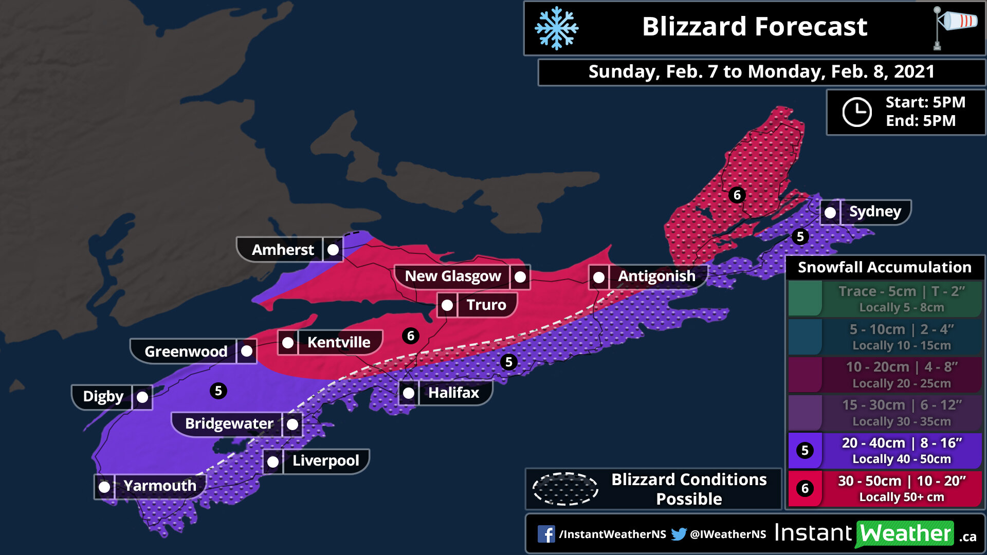
After a record low amount of snowfall for most of Nova Scotia, tomorrow’s storm will help change that with widespread amounts of 10-20cm expected by Saturday afternoon. Halifax could easily triple its season total for snow just from this one event!

The snow will approach from the southwest, first impacting the Yarmouth area at around 3:00am tomorrow morning. From there, it will spread across the province during the morning, reaching Sydney by noon. The heaviest snow is expected to fall during the morning in Western Nova Scotia at a rate of 2-2.5cm per hour which could last for up to 4 hours for the South Shore and into Halifax. This region will likely exceed 20cm of snow and there is a chance of up to 30cm. On the other hand, there will be a sliver of Western Cape Breton Island, including Cheticamp, where the snow will be steady, but light through the storm and 5-10cm of snow can be expected.

The snow will continue through the day tomorrow and will start to dissipate overnight in the west before making its way out of the province completely by noon on Saturday. There may be some isolated flurries in Cape Breton Island in the early afternoon Saturday, bring an additional couple of centimetres by the evening.

It’s important to note that the rain from this system will not be too far offshore so there is a slight chance for some mixed precipitation right along the Atlantic Coast. Any freezing rain will be brief and should not have much impact on total snow accumulation.

The daily forecast map is being included in this forecast because it’s fairly straight forward for tomorrow. The high temperatures will be 0° or a degree or two higher across the province with the snow that will be occurring throughout the day.

Significant Blizzard To Bring Up to 50cm of Snow and 90+km/h Wind Gusts to Nova Scotia Late Sunday Into Monday

A strengthening low-pressure system is set to track up the East Coast bringing widespread snowfall between 10-20cm on Sunday to the same areas that got pummeled by the powerful Nor’easter earlier in the week like New York and New England. This same system will also take aim at Nova Scotia with the system intensifying as it tracks just off the coast. As a result, we expect Nova Scotia to be on the cold side of this system and the predominant precipitation type will be snow. There might be some mixing along the coast with ice pellets and some freezing rain although that is very dependent on the system tracking closer to the coast and at the moment it looks unlikely.

Most of the precipitation will come down within a 12 hours timeframe across Nova Scotia mainly overnight into Monday morning. Rapid snowfall accumulation is expected during this time with hourly snowfall rates exceeding 5cm. Combined with strong wind gusts over 90km/h, this will likely create very hazardous conditions with near-zero visibility and drifting snow.

The first bands of precipitation will each the Yarmouth and Liverpool area starting around the dinner hour on Sunday and spreading northward throughout the evening. We expect the worst conditions will be found around midnight and into early Monday morning. The snow will begin to taper off from the south just after sunrise and continuing to move out throughout the day on Monday. Cape Breton will be the last to clear out with flurries lingering into the early evening on Monday. Everything should be done by the end of Monday as the system moves off into Newfoundland.

When it comes to total snowfall accumulation from this storm, we’re looking at widespread accumulation ranging from 20-40cm with locally up to 50cm. For those further inland, less precipitation is expected so generally, this would lead to lower snow totals, but colder temperatures (-1 to -2°C compared to -3 to -4°C inland) will also be found in these same areas. As a result, the slightly colder temperatures would mean a higher snow ratio (the amount of snow created from equivalent liquid precipitation; a higher ratio implies more snow for the same amount of precipitation) so further inland locations such as Kentville, Truro and New Glasgow could actually see between 30-50cm of accumulation. This may change should the system tracks further offshore than expected although it’s what the data currently shows.

Wind_NS.jpg

The heavy snowfall will also be accompanied by very strong wind gusts, especially along the coast. Wind gusts in those areas including locations such as Liverpool, Halifax and Sydney could exceed 90km/h mainly during the early morning hours on Monday. Further inland, the wind will be weaker although gusts will still peak at over 70km/h (over 80km/h for Cape Breton). This will likely create blizzard conditions for several hours particularly closer to the coast although it may extend quite far inland with the potential for blowing snow for the rest of the province that doesn’t quite reach blizzard criteria. The strong wind gusts will end later in the morning on Monday around the noon hour, but gusts between 60-80km/h may continue across Cape Breton into Tuesday.

If you can, just stay home starting Sunday evening until midday Monday when conditions should begin to improve. Roads throughout the province will be snow-covered with strong wind gusts causing near-zero visibility so travel will become near impossible at the height of this storm. Stay safe!

Nova Scotia to miss out on the Northern Lights show!

Issued: December 10th, 2020 @ 12 AM

Updated: December 10th, 2020 @ 12 AM

Forecaster: James Follette

A CME from the sun has reached the earth and it is possible that northern lights will be seen as far south as Oregon during the next couple of days.

But the question is, will the weather cooperate to make viewing possible? Well sadly the answer is no, We have unsettled weather over next 4 days that will bring nothing but clouds and precipitation.

A potential geomagnetic storm is predicted for tonight and Thursday.

Tonight, a small low pressure will bring scattered showers and flurries and plenty of clouds for the entire province, so tonight is not a great night to see the lights.

Tomorrow Night, There will still be lot’s of cloud cover, but less chance of precipitation. Good news is that there will be some areas in the province that will have clear breaks!

These counties include:

  • Cumberland

  • Colchester

  • Hants

  • Halifax East

  • Guysborough

  • Victoria

These counties will see the chance for a view of auroras on Thursday night.

For Friday Night & Saturday night, mostly cloudy skies will take over for the whole province again.

So best view for the mentioned counties is tomorrow night.

Clearing Begins! But So Does the Big Chill and Snowflakes! *Monday Storm Coverage*

Issued: November. 16th, 2020 @ 11: 30 AM

Updated: November. 16th, 2020 @ 3:30 PM

Forecaster: Student Meteorologist James Follett

Good Afternoon! It is 3:30 PM, and we have some new updates to talk about!

Storm Surge Warning and Special Weather Statements have now ENDED.

High wind warnings remain in effect for CB.

download (1).png

Looking at Radar right now, We have some heavy rain occurring over Northern Nova Scotia and more clearing to the South. We also have showers and downpours over New Brunswick and Maine, These will likely fade out somewhat, but don’t be surprised if some pop-up showers arrive near the Bay of Fundy.

Looking at current Wind Gusts,

https://meteologix.com/ca/observations/nova-scotia/gusts-10min/20201116-1900z.html

xx_obs-en-114-0_2020_11_16_19_00_1626_174.png

Here is a look at the latest Wind Gusts, Wind Gust of 80 km/h right now in Sydney. still have Gusts of Tropical Storm force which is over 64 km/h, as high as 70 km/h. Winds Gusting to the south still over 40-50 km/h.

nam-218-all-labrador-instant_ptype_3hr-1605528000-1605808800-1605830400-10.gif

Looking at the FutureCAST right now. NAM model shows fast clearing through the day with the rain ending this evening or overnight in CB, However, showers are possible.

Behind the storm is a very cold arctic mass and when that taps into the leftover moisture, the cold air above, and the warm waters below. we are looking at the potential for flurries and squalls Tomorrow Night and Wednesday. Sunshine and cold air continue the rest of the week.

As of 3:30 PM there are currently 11 active power outages that are affecting 29 customers. Down from 204 four hours ago.

That will do it for this Special Weather Update

Can catch other fast-breaking updates on our Facebook page, just go to Instant Weather NS. Or to our IW app for the latest radar and forecast!

Hope to catch you back here at 4 pm and you can catch the evening updates at 6,7,9,10 & 11!

Be safe, Be well, Buh-Bye!

...STRONG THUNDERSTORMS WILL AFFECT THE REGION OVERNIGHT TONIGHT...

Issued at 8:55 PM, October 10th, 2020

Valid for 11 PM, October, 10th, 2020

Forecaster: James Follette

rgem-all-labrador-kindex-2399600.png

A strong cold front will cross the region this Overnight and move off the coast by Morning, Scattered thunderstorms will accompany the front with wind gusts to 40 mph, small pea-sized

hail in a few spots and heavy downpours. In addition, there will be locally heavy rainfall. Any thunderstorm will contain dangerous lightning.

Due to the rapid movement of the storms and strong wind aloft, it is possible that an isolated thunderstorm could transport even stronger wind to the surface, and in very localized spots could produce wind damage and power outages.

Stay tuned to Instant Weather NS for the latest on these developing strong storm cells, and be sure to check out the IW weather app, with free radar. You can track the storms on your phone using our radar.

More on these storms later tonight!

Post-Tropical Hurricane Teddy Continues.... Worst Conditions Between Now and 6am

Updated: September 23, 2020 @ 12:35 AM

Valid : September 23, 2020 @ 1 AM

Forecaster: James Follette

233849_current_wind_sm.png

The Center of Post-Tropical Cyclone Teddy with sustained winds of 85 mph making it a Post-Tropical Hurricane force system as a category 1.

...POST-TROPICAL CYCLONE TEDDY HEADING TOWARD THE NOVA SCOTIA COAST... ...DESTRUCTIVE WAVES, HEAVY RAIN AND STRONG WINDS ARE EXPECTED FOR PORTIONS OF NOVA SCOTIA TONIGHT THROUGH WEDNESDAY...

The Conditions will get worst from here, There is Tropical Storm force winds covering all of Nova Scotia, PEI, Much of NB, and now entering Southern Newfoundland and Saint Pierre.

There is also Hurricane force winds just right off the coast near Shelburne, With the current track It seems more and more likely that Hurricane force winds will move in parts of Shelburne county.

Teddy is 305 km S of Halifax & 750 km SSW of Port Aux Basques.

Sustained winds are at 85 mph and still moving North

A Tropical Storm Warning is in effect for...

* South coast of Nova Scotia from Digby to Meat Cove

* Port aux Basques to Francois Newfoundland

A Tropical Storm Watch is in effect for...

* Meat Cove to Tidnish Nova Scotia

* North of Digby to Fort Lawrence Nova Scotia

* Magdalen Islands Quebec

* Prince Edward Island

A Tropical Storm Warning means that tropical storm conditions are

expected within the warning area.

A Tropical Storm Watch means that tropical storm conditions are

possible within the watch area.

Interests elsewhere in Atlantic Canada should closely monitor the progress of Teddy.

Teddy is an extremely large post-tropical cyclone. Hurricane-force

winds extend outward up to 125 miles (205 km) from the center and tropical-storm-force winds extend outward up to 540 miles (870 km). Buoy 44150, located about 60 n mi north of the center, recently reported a significant wave height of 36 ft (11 m).

Strong winds, Heavy rain, Coastal flooding, Storm surge will intensify through the night and become increasingly Dangerous and Life Threatening along the coast.

Life threatening Rip Currents and Gigantic swells and waves continue for days.

Widespread Power Outages Likely as Teddy Quickly Approaches

Updated: September 22nd, 2020 @ 9:45 AM

Valid: September 22nd, 2020 @ 10 AM

Forecaster: James Follette

Power Outages Forecast.jpg

Latest thoughts on Power Outages:

A wide swath of wide spread power outages are very likely from Yarmouth to Sydney. We have possible and likely power outages for Western NS.

Power outages will be mainly caused by falling trees & branches, snapping power poles, high winds, and heavy rain.

Power outages could last a few to several days, similar to Hurricane Juan and Tropical Storm Arthur.

Be safe, everyone!

Teddy To Pack a Punch Like Arthur or Juan! Down to Only Hours Before The Rain Arrives!

Updated: September 22, 2020 @ 9:16 AM

Valid: September 22, 2020 @ 9 AM

Forecaster: James Follette

Tropical Storm Teddy Impacts Map.jpg

Latest update and the potential impact threat!

Once again, the coastal areas are the ones that are at most risk for extreme impacts from storm surge, flooding rains, Tropical Storm to Hurricane force winds, rip currents, pounding surf affecting the beach & coastal erosion. This will be the area that will be a mess!

Further inland you go, the lesser the impacts. I'm thinking Western NS will only see a Slight to Moderate impact from heavy rain and gusty winds. Should not as bad as rest of the province but will be enough to cause some problems and power outages.

Southern Nova Scotia will see significant impacts. You're going to see those giant waves! Storm surge where it will be 50cm higher than normal, rip currents, and pounding surf. Those waves could be as high as 10-15 metres! And to top it off, heavy rains of possibly 40-50 mm in some places, which would even further flooding! And last but not least, you have the astronomically high tide!!

So flooding is one of the biggest concerns in that region, along with storm surge.

Then, you have the winds... If you’re closer to the track you will be in middle of the Tropical Storm force winds. Winds in these areas will gust as high as 105 to even 110 km/h, especially for towns in the Shelburne area, Clark's Harbour, Barrington Passage, and all the small islands and capes. They will be the ones to be beaten to a pulp more than any other towns in the South Shores.

Look for widespread power outages because there is still lots of foliage. The trees are going to be pressured and pushed really hard. They could fall and land on houses, cars, power lines and power lines could snap.

The only reason I didn’t put you on the Extreme Threat level is because of the winds should not reach over 110 km/h.

Be safe, everyone!

Hurricane Teddy to slam province with Tropical Storm force winds!

Updated: September 22nd, 2020 @ 7:45 AM

Valid: September 22nd, 2020 @ 8 AM

Forecaster: James Follette

Hurricane Teddy Wind Gusts Forecast.jpg

Here are the latest Peak Wind Gusts expected from Teddy.

Tropical Storm Force winds are winds 60 and above, and that will for sure be the case! however, lesser winds to the West where Gusts of only up to 80 km/h.

Closer to the coast, winds Gusting between 80 and 100 km/h, highest winds seems to be in NE Cape Breton where wind Gusts of 110+ is expected, and some models even suggest Gusts of near 130 km/h. Sustained winds in that area will be 90-100 km/h! These are winds that would create some serious wind damage, If there was any place to get the most damage and trees down it would very likely be North Eastern Cape Breton.

I am expecting some wind damage all along the coast, and trees and power lines likely be falling down as well along the coast.

~ James

The Ghost Of Paulette, comes back from the dead!

Updated: September 22, 2020 @ 12:45 AM

Valid: September 22, 2020 @ 6 AM

Forecaster: James Follette

AL172020_5day_cone_no_line_and_wind.png

A new Tropical Storm has developed!!! Everyone, let’s welcome back Tropical Storm Paulette to the Maury show!

This is Paulette's 2nd appearance in the tropics! On the first appearance Paulette was a Storm that Got Angry at Bermuda and have pummeled them as a Hurricane. Only to find out later on that The cold north Atlantic waters was NOT the perfect water father!

She died, and now she is back! and she says that she think that the Azores is responsible!

So everyone Welcome back Paulette!!!

Paulette is a 60 MPH small storm heading East-North East at a speedy 16 mph.

Paulette is threatening the Azores, for potential landfall on Friday as a Tropical Depression, However there are other models that put Paulette to become stronger, and move south so we’ll watch her for a bit but she is no threat to any land mass in this country!

September 21 11PM Update on Hurricane Teddy & it's race towards Nova Scotia

Updated: September 21 @ 11:55 PM

Valid: September 22 @ 12:00 AM

Forecaster: James Follette

Hurricane Teddy Impacts.jpg

Good Evening! Here is the latest on the track and data on Teddy.

First here is what you need to know about Hurricane Teddy current data.

Hurricane Teddy is continuing to move Northward away from Bermuda and increasing in speed, now at a speedy 26 mph.

Teddy is a Category 1 Hurricane with 90 mph winds and is still expected to strengthen Tonight Before weakening again as it nears landfall in Nova Scotia.

Now to Latest track forecast. Teddy is expected to first make landfall over Marie Joseph, then cross through St. Mary's & Goshen then St. Andrew's between Antigonish and Heatherton. all through the day on Tuesday Evening into Wednesday.

After that it will cross over waters between PEI and Cape Breton as a Post-Tropical Storm.

Teddy should make landfall as a Post-Tropical Hurricane with Category 1 winds of 80 mph. There is still a slight chance though that Teddy could maintain Hurricane status just before making landfall.

Nevertheless, Tropical Storm Conditions are expected all over the province, and Tropical Storm Warnings and watches are in place.

There is also Storm Surge warnings, Rainfall warnings & Wind warnings.

If you have not done so yet, to prepare for the storm, you will only have a few hours in the morning to do so before Teddy rushes in.

Storm drains should be cleared, Vulnerable trees cut down, patio furniture, Trampolines, Garbage bins and other objects brought inside before noon Tomorrow!

Should also have your storm plan in place and ready, Generators, food, and chargers ready in case of Power outages.

Storm kits, Emergency plans, Evacuation plans should be ready and viewed over.

Instant Weather Meteorologists and Forecasters will continue to keep you posted through out the storm coverage before, during and after the storm.

Stay safe! and Hunker down, because we have another Arthur on our footsteps!

Teddy to bring risk of Isolated Severe Thunderstorms to the province, along with Tropical Storm Conditions

Updated: September 21st, 2020 @ 9PM

Valid: September 21st, 2020 @ 9 PM

Forecaster: James Follette

Thunderstorm Forecast Tuesday.jpg

While There are Storm surge warnings, Flood warnings, Wind warnings, Tropical Storm watches and warnings all in effect ahead of Hurricane Teddy that is ready to bare down on Nova Scotia arriving Tomorrow morning with rain then wind and the thick of it in the Evening and Overnight hours.

Along with the Stormy conditions, there will also be a risk of some Isolated severe Thunderstorms.

For much of Nova Scotia, there will be a risk of Non-Severe Thunderstorms, however where the storm center will cross, there is more energy, and so there could be a few ISOLATED Severe thunder storms that could produce some large hail, Frequent Cloud to ground lightning, Strong wind Gusts on top of the Tropical Storm Force winds.

Teddy weakens to Category 2 with 105 mph winds, still on course to make direct hit on Nova Scotia

Brief Tropical Update # 1 Issued @ 11:23 AM

Valid @ 12:30 AM

Forecaster: James Follette

TROPICAL UPDATE.jpg

The latest update in from the NHC as of 8 AM, is that Hurricane Teddy has weakened to a Category 2 Hurricane with winds of 105 mph or 169 km/h. Pressure has also risen from 958 to 964mb.

The storm has also made a more of a jog towards the West more but still going in a NW direction to make the path now a WNW, with no change in speed at 12 mph.

simuawips (3).png

Despite the weakening of the system and a more westerly track, Teddy’s track has little to no change to it and Teddy is still on course to make landfall in Nova Scotia on Wednesday somewhere between Northern NS and Cape Breton.

The wind Radii ( Wind Field) still puts Tropical Storm force winds (60km/h SUSTAINED, not Gust) as far as Central New Brunswick, PEI, & Maine as shown in the graphic. Strong Tropical Storm Force winds ( 90 km/h or greater Sustained) is expected to occur over much of Nova Scotia from Cape Breton to Clark’s Harbour.

Western NS as of the latest update looks to escape the Strong Tropical Storm Force winds. This includes Yarmouth County, Digby County and the rest of Western NS. Winds in these area may not be Strong Tropical Storm Force, but they will still be Tropical Storm Force and so Wind Damage is still expected. Winds will be sustained of 60+ km/h with Gusts to 100 km/h.

Areas in Orange who will see Strong Tropical Storm Force will see Sustained winds at nearly 100 km/h with Gusts at Hurricane force potentially between 120 and 140 km/h.

Life Threatening Rip currents and Surf will continue to increase through the next several days, and the waters will be extremely dangerous all of next week, due to 2 other Tropical systems and a developing system to the North and the size of Teddy.

Very large waves will also increase in magnitude today and into Wednesday and Thursday.

Any boaters or fisherman, ship vessels are asked to take extreme caution as Hurricane conditions will continue in the open waters and for boaters closer to the coast, it’s highly recommended that you secure your boat Very tightly, or bring it on land.

  • As mentioned earlier, this is the time to prepare now as early as you can before Tuesday morning.

  • Cut down old weak trees that are capable of falling on wires, cars or houses

  • Trees with foliage being battered by Tropical Storm Force winds of 60+ sustained and 100 km/h Gust has the highest chance of breaking or falling down on wires, and with this said we expect several numerous trees down and lot’s of power outages similar to Tropical Storm Arthur.

  • Stock up on small food items for a few days incase of power outages

  • In case of power, be best to buy a Generator if don’t have one

  • Go through your Emergency storm kit

  • Go through your Hurricane Aid Kit

  • Go Through your Evacuations Hurricane Plan ( for those living right near the water)

  • BE SURE to clean the storm drains! so that water can flow freely down the storm drain to reduce the threat of flooding.

  • Be sure to have a weather radio and to keep checking regularly for new updates!

  • Check in on your family, friends and elders

Hurricane Teddy Update #1

Forecast Updated at September 20th @ 10:20 AM

Forecast Valid September 20th @ 11 AM

Forecaster: James Follett

TROPICAL UPDATE.jpg

Good Sunday Morning! This is Instant Weather Tropical Update #1 on Hurricane Teddy as it heads for Bermuda and Atlantic Canada.

As of the 5 AM update on Hurricane Teddy, Winds have dropped to now 105 MPH making it a Strong Category 2 Hurricane and it is now jogging to the WNW at 12 MPH and is expected to turn more Northward later today. The pressure has risen substantially to 964mb up from 958 just 3 hours ago.

Teddy's evolution for the next few days appears to be a tale of 3 troughs. Upper-level westerly flow associated with the first upper-level trough, affecting the storm now, is the most likely reason why the hurricane's structure has degraded and has taken on a slightly sheared appearance. Teddy will begin to encounter the 2nd trough, a deep frontal system approaching from the west, later today and that should cause the hurricane to turn north. This interaction should steer the center of Teddy east of Bermuda, but tropical storm impacts from either the large hurricane, the frontal system, or both are still likely Sunday evening through Monday night.

All indications are that Teddy will then continue generally northward and merge with the frontal system, nearing Nova Scotia as an extratropical cyclone early Wednesday. Teddy's maximum winds will likely decrease sharply after it becomes post-tropical, as shown by all the intensity guidance, but its gale and storm-force wind radii will likely increase at the same time. The cyclone should turn northeastward as the 3rd trough, another mid-latitude system, approaches from the west. Teddy could be absorbed by that feature in as soon as 120 h, though this is not explicitly shown in the forecast at this time. The spread in the track and intensity guidance is quite low and confidence in both aspects of the forecast is high. There is a little more uncertainty in the wind radii evolution, but it is clear that Teddy will produce strong winds over a wide area of the northwest Atlantic during the next couple of days.

The extent of 12-foot or higher seas associated with Teddy continues to increase. See the Key Message below regarding swells caused by the hurricane.

We now know more on the highest most likely impacts it will have on the Province of Nova Scotia and the rest of Atlantic Canada.

Hurricane Teddy’s Impacts On Nova Scotia

Hurricane Teddy Impacts.jpg

Highest threat of Hurricane and/or Tropical Storm conditions are Flooding & Wind damage. Where in many areas of the province sustained Tropical Storm force winds of 60-70 km/h will Gust up to 100-110 km/h and with lot’s of foliage on the trees, that will put more stress on the trees and will then break and/or fall, and these can fall on cars, power lines creating power outages. But also flying debris such as roof shingles, house sidings, signs, flower pots, Patio furniture, trampolines the biggest one!.

If you have any small objects that are light that can blow away and create damage, you have until Tuesday Morning to get it done! Things that should be brought in or taken down includes Flower pots, Patio furniture, Trampolines, etc.

Along with objects, it is very important that you cut down any potential tree branches that are old or look weak that has the potential too fall down on the house, or car, this can be done up until Monday Night.

After noon time on Tuesday, time will be up and all bets are off, as Tropical Storm force winds arrive shortly after noon hour, Rain at times heavy begin over Eastern NS and South Shores Tuesday late Morning between 9 and 11 AM.

The next threat then is the flooding, which will be a very big threat for much of Eastern NS and Northern NS with up to 100 mm is expected, further South the amounts are less where only up to 30 mm will fall regardless of how much rain falls, torrential tropical downpours can cause flash flooding, as well as Street, coastal and urban flooding. It is very important that you clean up the storm drains on your street next to you, flooding becomes fast all the time when storm drains are clogged and water cant fall down. This must be done before Tomorrow Night.

Other types of flooding includes Coastal flooding, low lying areas near the water can get severe flooding from Storm surge, and to make things worst is that this storm comes on a night of Astronomical High Tide. Big waves of over 12ft, giant surfs, storm surge and the high heavy rain amounts will cause extreme flooding threats for communities near the water all up and down the coast of Nova Scotia, with exception to Bay of Fundy where land interaction and opposite wind direction will create a lower flooding threat.

Beach erosion is also very likely along all ocean facing Beaches.

Tornadoes… As with all Tropical Cyclones, there is the risk of Tornadoes because of the circulation. how ever the threat for Tornadoes are very low as there will not be much convection as storm weakens.

Hurricane Teddy Wind Field

Hurricane Teddy Wind force.jpg

Correction: Tues, Sept 22nd*

The current track of Teddy puts it heading for extreme Eastern Cape Breton, around Sydney. However as the Hurricane tracks North on it’s way over the next few days and transitions to Post-Tropical the Wind Radii begins to expand, so even though the center of storm may be far offshore, the Tropical Storm Force winds and Tropical Storm conditions will spread all through Southern, South Shores and Western Nova Scotia beginning Tuesday Morning into Wednesday Night.

For Northern Nova Scotia & Cape Breton, The storm will pass very close and will intensify just a little, producing Hurricane force winds that may reach the area, never the less the area will still see Tropical Storm force winds sustained.

Power outages very likely!

Power Outages Forecast.jpg

Correction: Tues, Sept 22nd*

Wide spread Outages can be expected through Southern Shores, Northern NS, & Eastern Cape Breton.

Outages that are likely or very likely covers a big area of the province. much of Tri-Counties up through Halifax and Northern NS into New Glascow as well as Western Cape Breton, for Eastern NS, and parts of Kings and Annapolis Valley will see some possible Outages through Wednesday Night.

Hurricane Teddy Rainfall Intensity Forecast

Hurricane Teddy Rainfall Intensity Tues. Morn-Aft.jpg

Rain will start Early to Mid Tuesday morning, Moderate rain will come from the East, a more lighter rainfall for Western side of the province, as well Cape Breton.

Hurricane Teddy Rainfall Intensity Tues. Eve-Ovr.jpg

By the time we get into the Evening and Overnight hours, we’ll see Moderate to Heavy rain much of province except for Northern and Cape Breton, where very Heavy rainfall is expected, look at 20+ mm/hr rates

Hurricane Teddy Rainfall Intensity Wed. Morning-Afternoon.jpg

By Wednesday, the rain and heavy rain continues especially if in Eastern, Central & Northern parts of the province. By time we are at mid day Wednesday we will have very heavy rain that have rates of 30+ mm/hr, this is where you 70-100+ mm totals come from.

Hurricane Teddy Rainfall Intensity Wed. Evening-Overnight.jpg

By Wednesday Evening into the Overnight, much of the province will see the rain shut off, however some light to Moderate rain continues over Western Cape Breton from Antigonish to Sydney.

Hurricane Teddy Rainfall Intensity Thursday Morning-Afternoon.jpg

As the system pulls away heading for the Island of Newfoundland, still will be a few left over showers over Eastern Cape Breton.

Thunder Storms Likely Tuesday & Wednesday!

Now with Heavy rain, and a lot of Energy and this is a tropical System.. How about Thunderstorms? yup they’re a possibility!

Thunderstorm Forecast Tuesday.jpg

On Tuesday, the entire province has a Isolated Severe risk of Severe Thunderstorms.

Thunderstorm Forecast Wednesday.jpg

Now on Wednesday, as the storm pulls North, we’ll see a Severe risk of Thunder storms and Isolated in Cape Breton!

Teddy’s Impacts!

Tropical Storm Teddy Impacts Map.jpg

Correction: Tues, Sept 22nd*

The biggest impacts will be in Cape Breton as that is where the center will track. but much of the province will see a big impact! From Yarmouth to Antigonish expect Significant Impact, This also includes Digby and Greenwood!

Then Kentville, Amherst, New Glascow, Truro will a lesser impact, but still a Moderate Impact to winds and rain, but not so much storm surge.

Teddy’s Rainfall Through Thursday Morning.

Hurricane Teddy Rainfall Amounts.jpg

Correction: Tues, Sept 22nd*

For Southern, Southern Shores, Annapolis Valley, Kings counties, much of Eastern Cape Breton. You will see the least amount of rain, do to the fast speed, so a wind issue rather than rain. However that is not to say you won’t get anything!! 15 to 30 mm is in the forecast, and there could be some local amounts of 30-40 mm . For Halifax, Halifax Metro, Truro, Amherst. Look at 25 to 50 mm with locally 50 to 70 mm. This is where the Flooding threat is expected. For New Glascow and and surrounding areas, 40 to as much as 75 mm! and you could have locally some amounts approaching 100 mm. Antigonish and remaining areas, look for the heaviest rain, to create severe flood risk, 75 to 125 mm of rainfall with locally some amounts approaching 125 mm.

Teddy’s Winds Through Thursday

Hurricane Teddy Wind Gusts Forecast.jpg

Correction: Tues, Sept 22nd*

A wide swath of the province will see winds between 80 and 100 km/h Gusts. Cape Breton is exception, where they will see the most winds! of Winds Gusting to 110+ km/h , least winds can be found in Western sections such as East of Kentville, Truro, Kentville. winds Gusting 80 to 95 km/h which is Tropical Storm force, anything over 60 km/h is Tropical Storm force.

Teddy’s Hazards

Hurricane Teddy Hazards.jpg

Damaging Wind risk is fairly high! along with Severe weather and Travel can be quite Significant. Flood risk is Moderate to High and the Confidence on the forecast is a bit better now at 75-100%, which is pretty good, however still a few things needs watching that can change the system.

What to do! and How to Prepare!

The Storm is now only about 48 hours away, and with the very high likely hood of a dangerous direct impact on the province. It’s time to prepare! and Go over the Emergency Preparations

What to do before the Hurricane arrives!:

  • Get water, Bread, can food that will last up to 3 days.

  • Buy a Generator!

  • take down old, weak large tree branches that has potential to fall down on your car or house.

  • clean up near the storm drains, make sure there is plenty of room for the water to flow down.

    What to Have during the storm and what to go over:

  • . A flash light

  • Batteries

  • Weather Radio

  • canned food

  • An emergency kit

  • Gas ready in car

  • Money

  • Generator for long lasting Power Outages

You Should be going over the Hurricane kit and Emergency plan with the family.

  • Go over what to do before, During & After the Hurricane or Tropical Storm.

  • Have a Emergency Aid kit! and go over the items with the Family

  • Have an Evacuation Hurricane Plan!! For those living near the coast, where severe flooding and beach erosion is very likely, Coastal evacuations may be needed, Go over what to do in the case of an evacuation

    AND MOST OF ALL….

  • Stay Calm!!!

  • Pandemic rules still apply!!

  • Keep a distance of 6ft!

  • Wear a Mask!!

  • Wash your hands frequently!

Be Safe! and have a great Sunday Morning

  • Next Update is at 4 PM