Post-Tropical Hurricane Teddy Continues.... Worst Conditions Between Now and 6am

Updated: September 23, 2020 @ 12:35 AM

Valid : September 23, 2020 @ 1 AM

Forecaster: James Follette

233849_current_wind_sm.png

The Center of Post-Tropical Cyclone Teddy with sustained winds of 85 mph making it a Post-Tropical Hurricane force system as a category 1.

...POST-TROPICAL CYCLONE TEDDY HEADING TOWARD THE NOVA SCOTIA COAST... ...DESTRUCTIVE WAVES, HEAVY RAIN AND STRONG WINDS ARE EXPECTED FOR PORTIONS OF NOVA SCOTIA TONIGHT THROUGH WEDNESDAY...

The Conditions will get worst from here, There is Tropical Storm force winds covering all of Nova Scotia, PEI, Much of NB, and now entering Southern Newfoundland and Saint Pierre.

There is also Hurricane force winds just right off the coast near Shelburne, With the current track It seems more and more likely that Hurricane force winds will move in parts of Shelburne county.

Teddy is 305 km S of Halifax & 750 km SSW of Port Aux Basques.

Sustained winds are at 85 mph and still moving North

A Tropical Storm Warning is in effect for...

* South coast of Nova Scotia from Digby to Meat Cove

* Port aux Basques to Francois Newfoundland

A Tropical Storm Watch is in effect for...

* Meat Cove to Tidnish Nova Scotia

* North of Digby to Fort Lawrence Nova Scotia

* Magdalen Islands Quebec

* Prince Edward Island

A Tropical Storm Warning means that tropical storm conditions are

expected within the warning area.

A Tropical Storm Watch means that tropical storm conditions are

possible within the watch area.

Interests elsewhere in Atlantic Canada should closely monitor the progress of Teddy.

Teddy is an extremely large post-tropical cyclone. Hurricane-force

winds extend outward up to 125 miles (205 km) from the center and tropical-storm-force winds extend outward up to 540 miles (870 km). Buoy 44150, located about 60 n mi north of the center, recently reported a significant wave height of 36 ft (11 m).

Strong winds, Heavy rain, Coastal flooding, Storm surge will intensify through the night and become increasingly Dangerous and Life Threatening along the coast.

Life threatening Rip Currents and Gigantic swells and waves continue for days.

Post-Tropical Cyclone Teddy sets eyes on Newfoundland

Updated: September 22, 2020 @ 11PM

Valid: September 22, 2020 @ 11 PM

Forecasters: James Follette & Alannah Franks

120076188_322358685693009_3932450585939770531_n.jpg

What was once Hurricane Teddy is now a monster sized and very powerful Post-Tropical Cyclone is currently pummeling the Atlantic Canada with Tropical Storm conditions in Nova Scotia, PEI, New Brunswick and Southern Maine.

As of 9 PM, Tropical Storm conditions have started moving into Port-Aux Basques and St. Pierre.

The Track is expected to take it over Cape Breton and then stay just offshore of Western Newfoundland as a strong Post Tropical Storm.

Heavy flooding rain is expected over the Avalon and Burin Peninsula as well as all of Southern Newfoundland through Port-Aux Basques and up to Clarenville. the least rainfall will be in Northern and Western Newfoundland with 15 to 30 mm, Up to 75 mm can fall in Eastern Newfoundland and up to 50 mm in Southern.

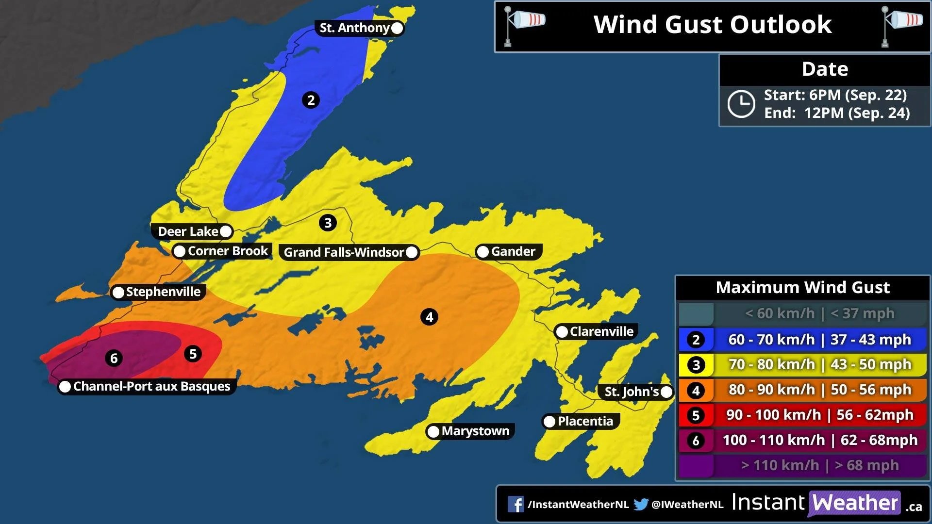
As for winds now, Winds will be the strongest in the West and the lightest in the East.

120085063_784597065705553_1752508699534331590_n.jpg

Winds in SW will be as high as 110 km/h, much of Western and Central will see Gusts up to 90 km/h, then further away, Northern Newfoundland, only up to 70 km/h and wide swath of up to 80 km/h for the Avalon, Burin Peninsula, Clarenville, Gander, GFW, Deer Lake, Corner Brook all will see Gusts up to 80 km/h.

With the Heavy rain and high winds, Scattered to widespread power outages is possible, The storm will arrive on Wednesday and last through Thursday.

Tropical Storm warnings are already in effect for South Western Newfoundland, large waves and rip currents, Storm surge is also expected.

Teddy To Pack a Punch Like Arthur or Juan! Down to Only Hours Before The Rain Arrives!

Updated: September 22, 2020 @ 9:16 AM

Valid: September 22, 2020 @ 9 AM

Forecaster: James Follette

Tropical Storm Teddy Impacts Map.jpg

Latest update and the potential impact threat!

Once again, the coastal areas are the ones that are at most risk for extreme impacts from storm surge, flooding rains, Tropical Storm to Hurricane force winds, rip currents, pounding surf affecting the beach & coastal erosion. This will be the area that will be a mess!

Further inland you go, the lesser the impacts. I'm thinking Western NS will only see a Slight to Moderate impact from heavy rain and gusty winds. Should not as bad as rest of the province but will be enough to cause some problems and power outages.

Southern Nova Scotia will see significant impacts. You're going to see those giant waves! Storm surge where it will be 50cm higher than normal, rip currents, and pounding surf. Those waves could be as high as 10-15 metres! And to top it off, heavy rains of possibly 40-50 mm in some places, which would even further flooding! And last but not least, you have the astronomically high tide!!

So flooding is one of the biggest concerns in that region, along with storm surge.

Then, you have the winds... If you’re closer to the track you will be in middle of the Tropical Storm force winds. Winds in these areas will gust as high as 105 to even 110 km/h, especially for towns in the Shelburne area, Clark's Harbour, Barrington Passage, and all the small islands and capes. They will be the ones to be beaten to a pulp more than any other towns in the South Shores.

Look for widespread power outages because there is still lots of foliage. The trees are going to be pressured and pushed really hard. They could fall and land on houses, cars, power lines and power lines could snap.

The only reason I didn’t put you on the Extreme Threat level is because of the winds should not reach over 110 km/h.

Be safe, everyone!

September 21 11PM Update on Hurricane Teddy & it's race towards Nova Scotia

Updated: September 21 @ 11:55 PM

Valid: September 22 @ 12:00 AM

Forecaster: James Follette

Hurricane Teddy Impacts.jpg

Good Evening! Here is the latest on the track and data on Teddy.

First here is what you need to know about Hurricane Teddy current data.

Hurricane Teddy is continuing to move Northward away from Bermuda and increasing in speed, now at a speedy 26 mph.

Teddy is a Category 1 Hurricane with 90 mph winds and is still expected to strengthen Tonight Before weakening again as it nears landfall in Nova Scotia.

Now to Latest track forecast. Teddy is expected to first make landfall over Marie Joseph, then cross through St. Mary's & Goshen then St. Andrew's between Antigonish and Heatherton. all through the day on Tuesday Evening into Wednesday.

After that it will cross over waters between PEI and Cape Breton as a Post-Tropical Storm.

Teddy should make landfall as a Post-Tropical Hurricane with Category 1 winds of 80 mph. There is still a slight chance though that Teddy could maintain Hurricane status just before making landfall.

Nevertheless, Tropical Storm Conditions are expected all over the province, and Tropical Storm Warnings and watches are in place.

There is also Storm Surge warnings, Rainfall warnings & Wind warnings.

If you have not done so yet, to prepare for the storm, you will only have a few hours in the morning to do so before Teddy rushes in.

Storm drains should be cleared, Vulnerable trees cut down, patio furniture, Trampolines, Garbage bins and other objects brought inside before noon Tomorrow!

Should also have your storm plan in place and ready, Generators, food, and chargers ready in case of Power outages.

Storm kits, Emergency plans, Evacuation plans should be ready and viewed over.

Instant Weather Meteorologists and Forecasters will continue to keep you posted through out the storm coverage before, during and after the storm.

Stay safe! and Hunker down, because we have another Arthur on our footsteps!

Teddy to bring risk of Isolated Severe Thunderstorms to the province, along with Tropical Storm Conditions

Updated: September 21st, 2020 @ 9PM

Valid: September 21st, 2020 @ 9 PM

Forecaster: James Follette

Thunderstorm Forecast Tuesday.jpg

While There are Storm surge warnings, Flood warnings, Wind warnings, Tropical Storm watches and warnings all in effect ahead of Hurricane Teddy that is ready to bare down on Nova Scotia arriving Tomorrow morning with rain then wind and the thick of it in the Evening and Overnight hours.

Along with the Stormy conditions, there will also be a risk of some Isolated severe Thunderstorms.

For much of Nova Scotia, there will be a risk of Non-Severe Thunderstorms, however where the storm center will cross, there is more energy, and so there could be a few ISOLATED Severe thunder storms that could produce some large hail, Frequent Cloud to ground lightning, Strong wind Gusts on top of the Tropical Storm Force winds.

Teddy weakens to Category 2 with 105 mph winds, still on course to make direct hit on Nova Scotia

Brief Tropical Update # 1 Issued @ 11:23 AM

Valid @ 12:30 AM

Forecaster: James Follette

TROPICAL UPDATE.jpg

The latest update in from the NHC as of 8 AM, is that Hurricane Teddy has weakened to a Category 2 Hurricane with winds of 105 mph or 169 km/h. Pressure has also risen from 958 to 964mb.

The storm has also made a more of a jog towards the West more but still going in a NW direction to make the path now a WNW, with no change in speed at 12 mph.

simuawips (3).png

Despite the weakening of the system and a more westerly track, Teddy’s track has little to no change to it and Teddy is still on course to make landfall in Nova Scotia on Wednesday somewhere between Northern NS and Cape Breton.

The wind Radii ( Wind Field) still puts Tropical Storm force winds (60km/h SUSTAINED, not Gust) as far as Central New Brunswick, PEI, & Maine as shown in the graphic. Strong Tropical Storm Force winds ( 90 km/h or greater Sustained) is expected to occur over much of Nova Scotia from Cape Breton to Clark’s Harbour.

Western NS as of the latest update looks to escape the Strong Tropical Storm Force winds. This includes Yarmouth County, Digby County and the rest of Western NS. Winds in these area may not be Strong Tropical Storm Force, but they will still be Tropical Storm Force and so Wind Damage is still expected. Winds will be sustained of 60+ km/h with Gusts to 100 km/h.

Areas in Orange who will see Strong Tropical Storm Force will see Sustained winds at nearly 100 km/h with Gusts at Hurricane force potentially between 120 and 140 km/h.

Life Threatening Rip currents and Surf will continue to increase through the next several days, and the waters will be extremely dangerous all of next week, due to 2 other Tropical systems and a developing system to the North and the size of Teddy.

Very large waves will also increase in magnitude today and into Wednesday and Thursday.

Any boaters or fisherman, ship vessels are asked to take extreme caution as Hurricane conditions will continue in the open waters and for boaters closer to the coast, it’s highly recommended that you secure your boat Very tightly, or bring it on land.

  • As mentioned earlier, this is the time to prepare now as early as you can before Tuesday morning.

  • Cut down old weak trees that are capable of falling on wires, cars or houses

  • Trees with foliage being battered by Tropical Storm Force winds of 60+ sustained and 100 km/h Gust has the highest chance of breaking or falling down on wires, and with this said we expect several numerous trees down and lot’s of power outages similar to Tropical Storm Arthur.

  • Stock up on small food items for a few days incase of power outages

  • In case of power, be best to buy a Generator if don’t have one

  • Go through your Emergency storm kit

  • Go through your Hurricane Aid Kit

  • Go Through your Evacuations Hurricane Plan ( for those living right near the water)

  • BE SURE to clean the storm drains! so that water can flow freely down the storm drain to reduce the threat of flooding.

  • Be sure to have a weather radio and to keep checking regularly for new updates!

  • Check in on your family, friends and elders