Update: Heavy Freezing Rain Risk Extended Southeast, Eastern Newfoundland Impacts Increased

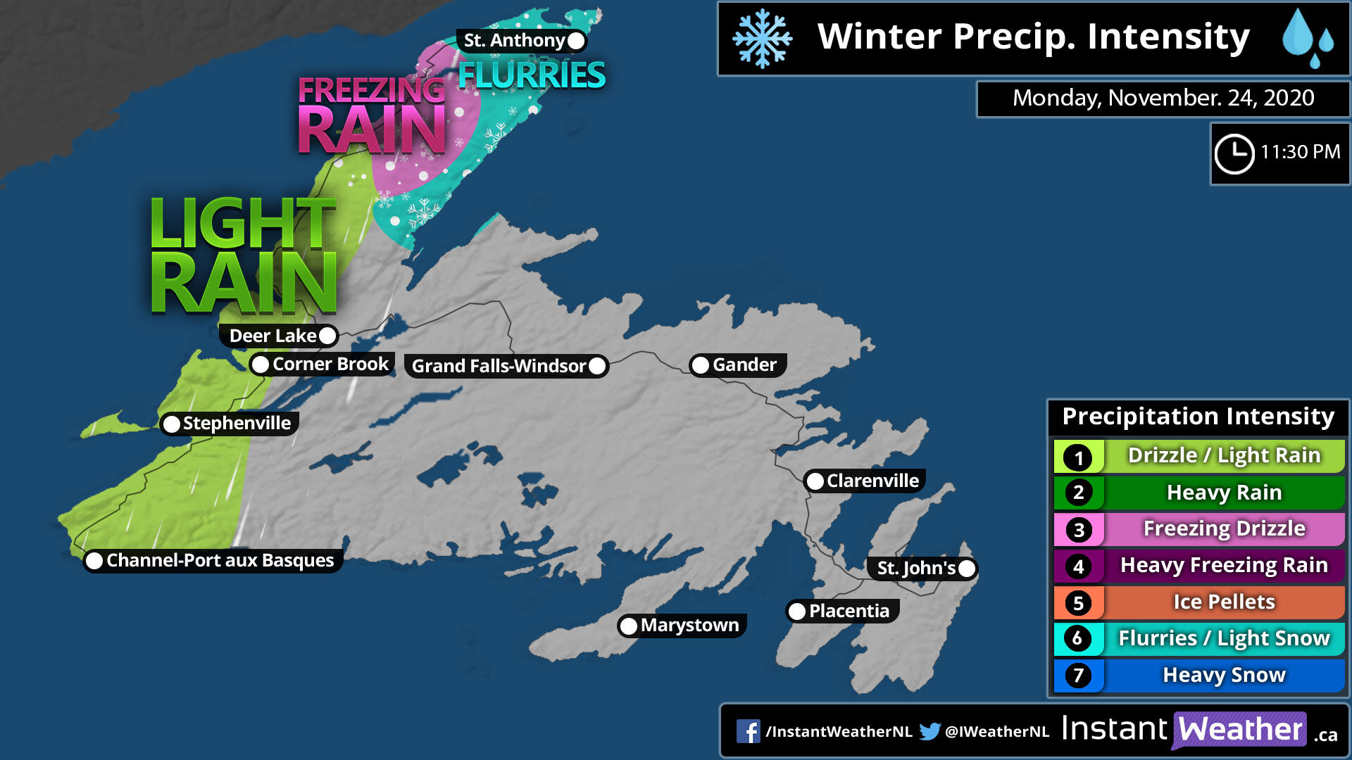
After reviewing the latest model data, we've updated our freezing rain forecast to reflect a southeast shift in the heaviest precipitation and to include additional freezing rain expected for Monday morning.

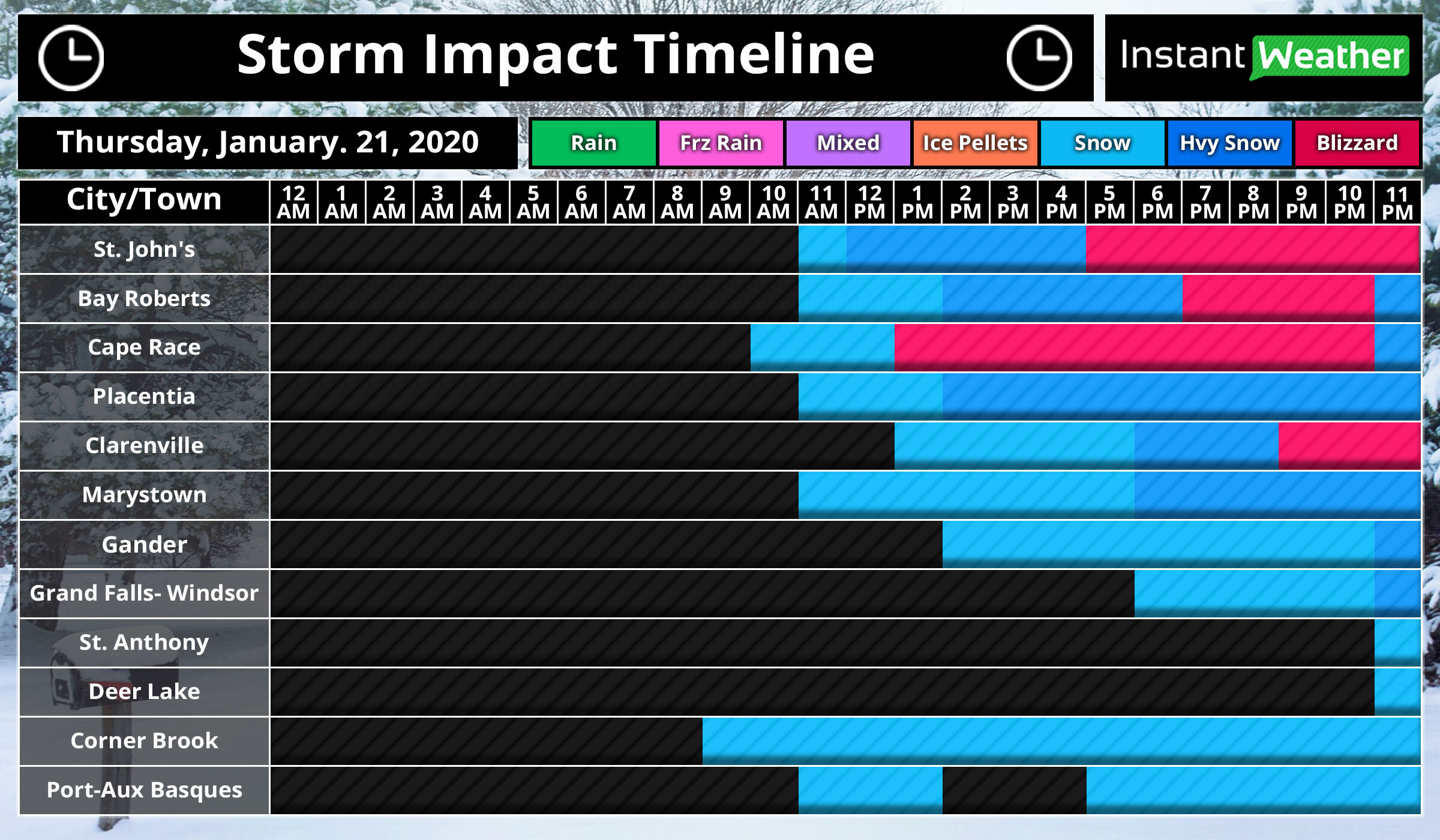
Corner Brook and Deer Lake will still get significant ice accretion, but it is a bit less than originally expected. From Gander, through Terra Nova, to Clarenville can now expect to impacted more by the storm.

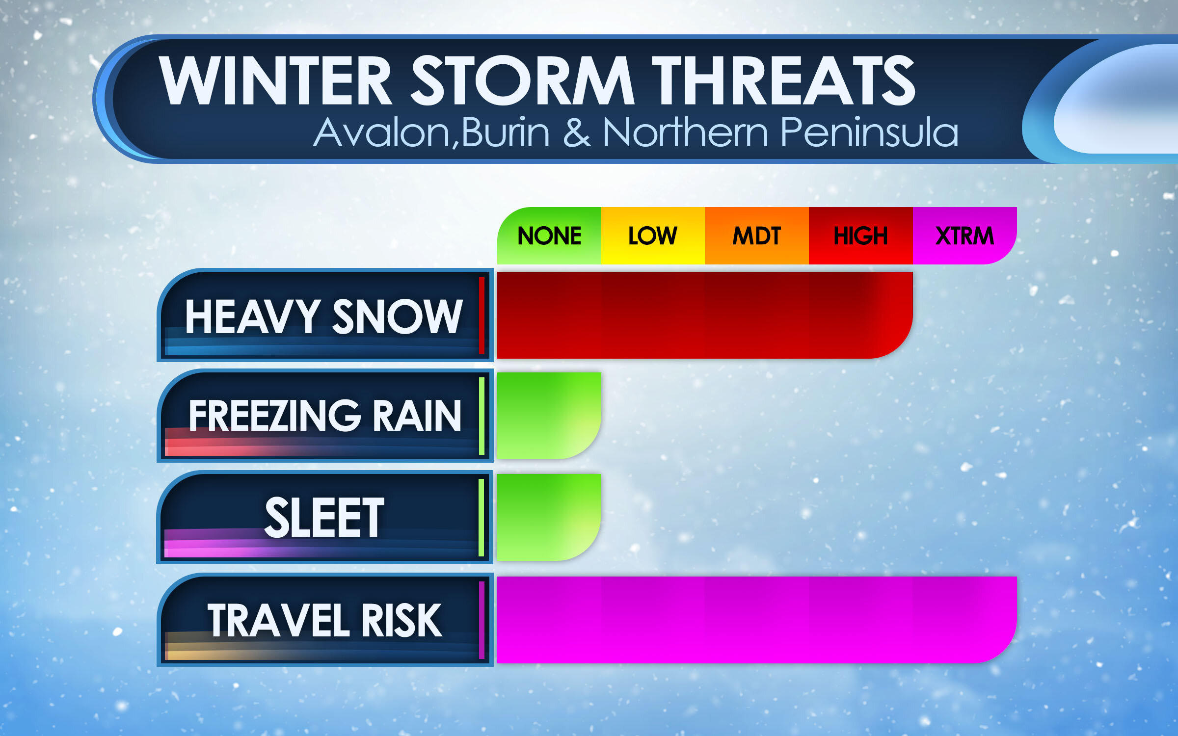
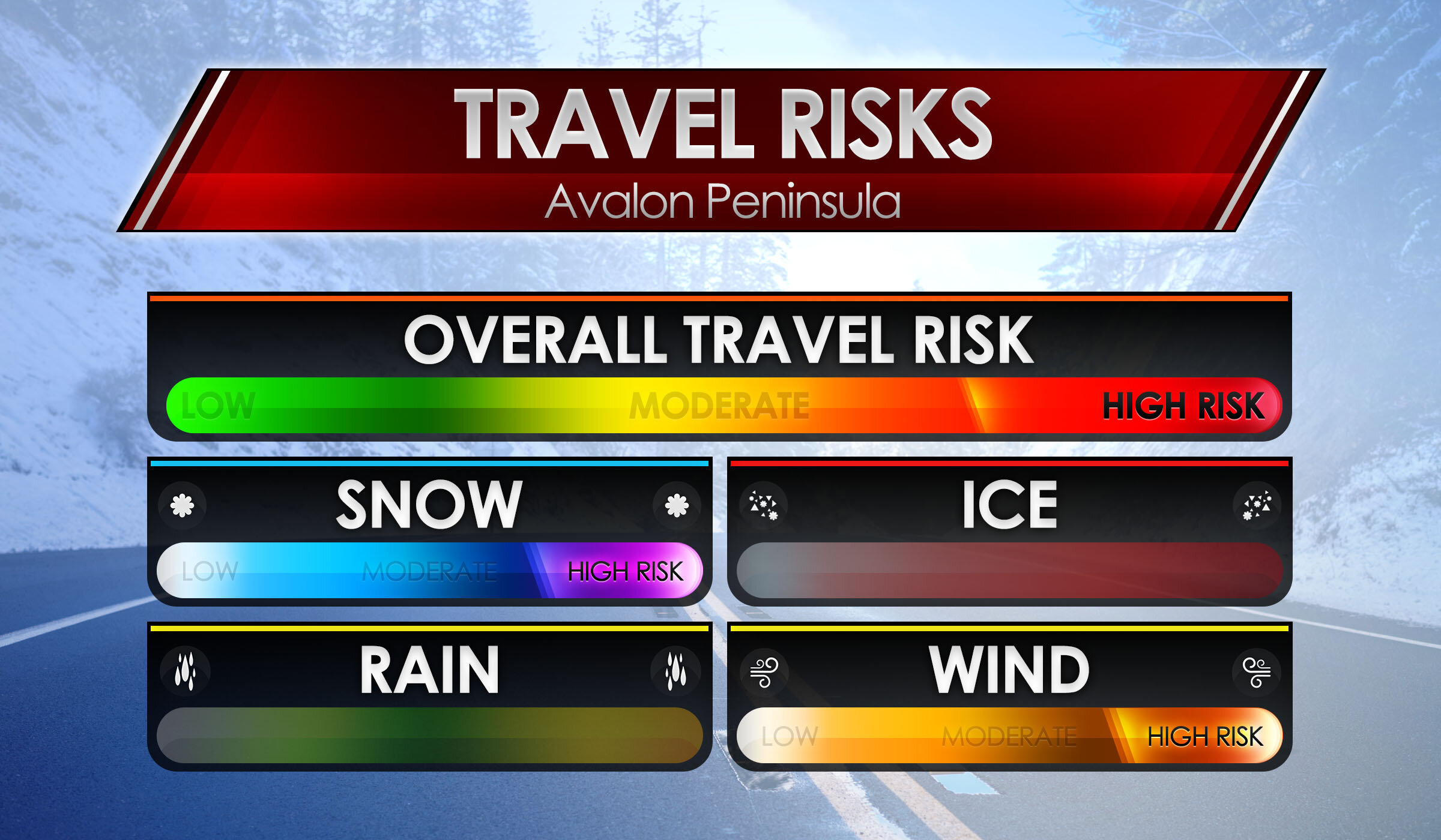
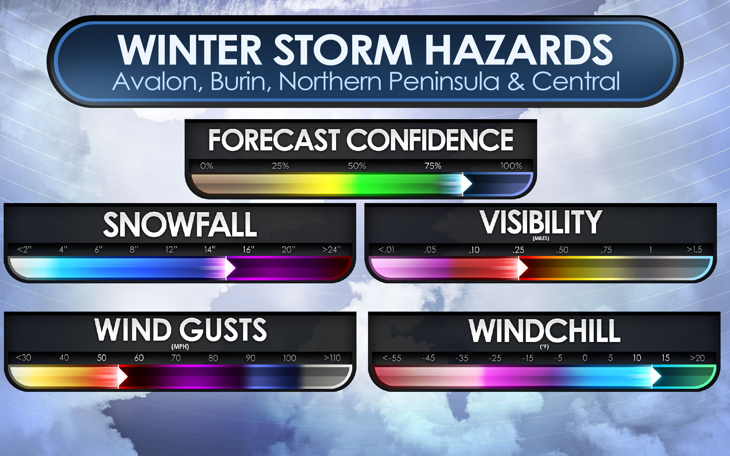
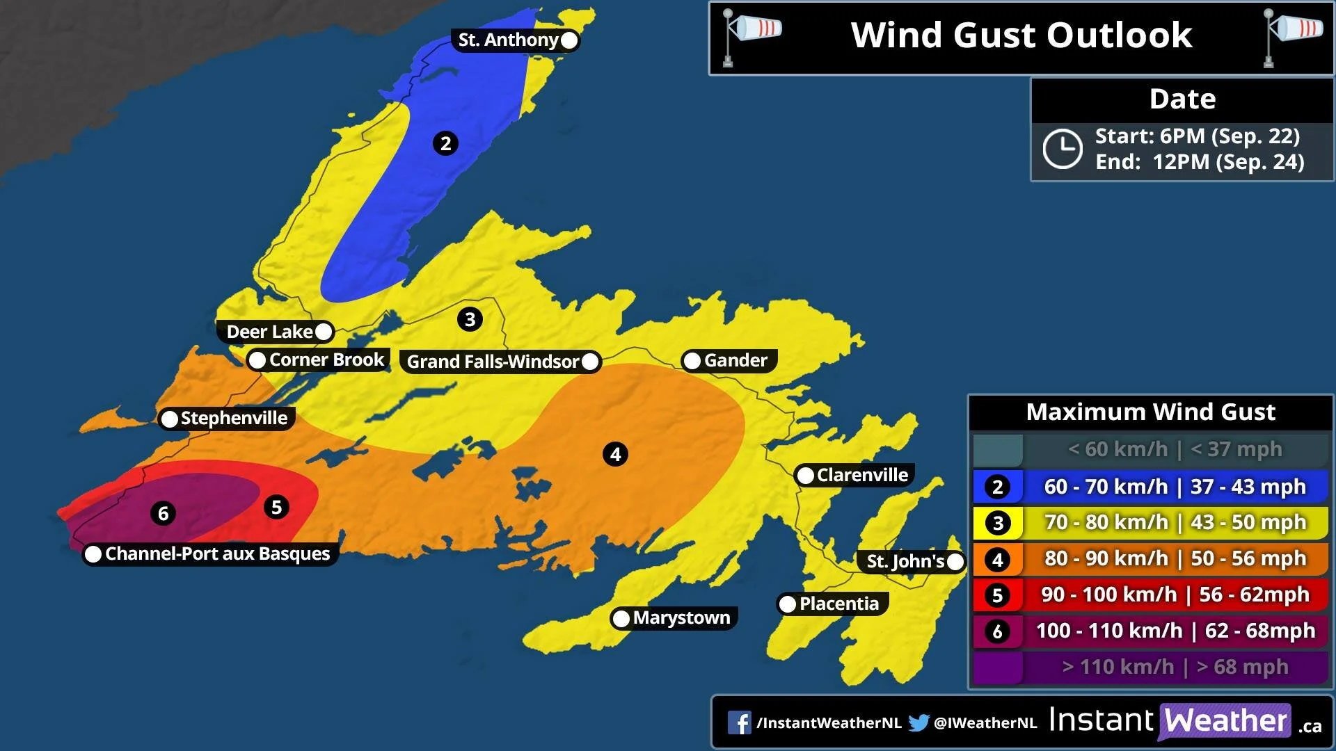
Typically, 10mm of ice accretion from freezing rain is enough to damage trees and power lines. Beyond that, with 25+mm, we could be looking at extensive damage. Wind gusts appear to remain light through the day tomorrow and into Sunday morning, but will pick up by Sunday afternoon. Gusts will be in the 40-50km/h range and this could trigger additional damage to trees and power lines.

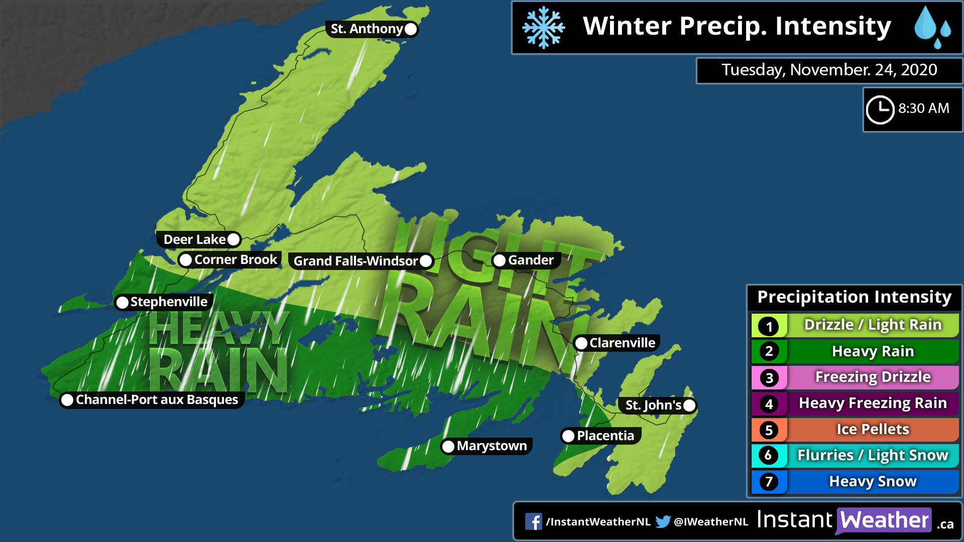
We've already begun to see some light freezing rain around Port aux Basques with the transition from snow to rain and in the early morning hours, there will be a pocket hitting the Corner Brook and Deer Lake area. It will spread south and east through the morning and by mid-afternoon, the heaviest freezing rain will start and it will last into overnight. The freezing rain will continue throughout the day Sunday and into Monday morning, but it will be focused over Central and Eastern Newfoundland, giving Western Newfoundland a reprieve.

Larry To Make Landfall Late Friday on the Avalon Peninsula as a Category 1 Hurricane

Hurricane Larry is expected to finally make landfall this evening over the western Avalon Peninsula as a Category 1 storm. Hurricane warnings are in effect for the entire Avalon Peninsula while Tropical Storm warnings are in effect from the Bonavista Peninsula, through Clarenville and south to Connaigre and the Burin Peninsula. The greatest threats from this storm are high winds, large waves, coastal flooding, and periods of heavy rainfall with up to 50mm falling.

Winds will begin to increase as Larry approaches with peak winds expected in the overnight hours. The strongest wind gusts will be along the coastal areas of the Avalon, especially in Cape Race and along the southern shore. Gusts of up to 150km/h are possible there and the winds will decrease further north and inland, with gusts of up to 130km/h possible for the St John’s Metro area and Conception Bay South through to Carbonear. Wind gusts of 100-110km/h will occur from Bonavista and south through the Burin Peninsula and winds will decrease moving westward. Any loose objects should be secured or brought inside ahead of the storm. By Saturday afternoon, winds should begin to diminish as Larry tracks offshore to the north and weakens to post-tropical storm in the cooler waters.

Along with the winds, waves and storm surge are a major threat from this storm, especially south facing shores from McCallum to Cape Race as well as in Placentia Bay. High tide this evening in conjunction with the storm surge will result in significantly higher water levels. Waves heights of 10-14 metres will also be present and could cause damage along the coast and flooding in coastal communities.

It is likely that some communities may lose power due to this storm and it is not too late to put together an emergency kit. Some important things to have on hand include:

  • Water

  • Non-perishable foods

  • First Aid kit

  • Battery powered flashlight and extra batteries

  • Candles and matches/lighter

  • Prescription medications and equipment

  • Pet food and supplies

  • Extra gas for generators

Please remember that if you use a generator, DO NOT operate inside your home, garage, or shed.

Stay safe and we will be posting updates this evening as the storm approaches.

Blizzard To Slam Much of the Island With First Big Snowfall of 2021!

Issued: January. 21, 2021 @ 12:10 PM

Updated: January. 21, 2021 @ 12:10 PM

Forecaster: James Follett

Winter Storm II.jpg

The first big snowstorm of the new year 2021 is now already approaching the province with some light snow and increasing winds, making it look lovely for now, but it’s about to look like a marshmallow world in the city! The heavy snow will quickly move in later this afternoon and evening hours, with the worst conditions between 5pm and 11pm on the Avalon Peninsula, but the moderate snow will continue through the overnight and continue into the early morning with periods of light snow still continuing to fall through the day, and even continue all the way into the weekend!

NFLD Storm Timeline.JPG

The storm has arrived on time right around the noon hour for St. John’s, we will expect that snow to quickly become steadier and heavier as the next few hours go by then it really gets bad by the time we get into the supper hour! Between 5 pm and 11 pm, we could see blizzard conditions!

The further west you go, the later the snow will arrive for you! Gander, Grand Falls- Windsor will see the snow starting later in the afternoon and early evening hours and by the time you reach St. Anthony & Deer Lake, expect the snow to not start until near 11 O’clock tonight!

On and off snow continues today for Corner Brook and Port-Aux-Basques.

Video Block
Double-click here to add a video by URL or embed code. Learn more

As can see by the radar, and futurecast, the snow has already engulfed the entire Avalon Peninsula and will continue to spread north and west through today and tonight as it increases in intensity. You may also notice that when playing the radar, the rain/snow and mix line gets rather fairly close to the southeast near Cape Race. I wouldn’t rule out the possibility of some Freezing rain or Ice pellets in that area later this evening. If it does then snow amounts will likely be a bit lower than forecast and some tweaks to the snow map may be needed.

NFLD Storm Winter storm threats Peninsulas 1.JPG

Here are the main threats with this winter storm, for the Peninsulas of Avalon, Burin and Northern Peninsula. The main threat is the Heavy snow and Travel risk! We are looking at high snowfall rates as much as 5-10cm per hour at times, many models put 40cm for St. John’s and surrounding areas. the heavy snow and combined strong wind gusts of 80-100 km/h will create blizzard conditions which will result in very hazardous travel, and for that reason the Travel Risk is at Extreme.

Central Winter Storm Threats.JPG

For Central areas, The impact is less severe as the storm will be a bit far, and the heaviest snow will miss. However, there still will be a lot of snow and strong gusty winds causing low visibility! a Moderate risk for Heavy snow, but it’s that Travel Risk that is the main Hazard! A very High Hazard, with as much as 15-25cm can fall in that area.

Avalon Peninsula Travel Risk.JPG

Here are the main risks for your travel risks! We’ll start with the Avalon Peninsula as that will be the hardest hit areas! Biggest risks are Snow & Wind, as we are on the colder side of the storm, snowfall amounts as much as 30 to 40cm can fall by Saturday morning! Whipped up by a high risk for winds as winds top 80-100 km/h. This will cause extensive blowing and drifting snow causing extreme low visibilities and Blizzard conditions, Overall Travel risk for the Avalon Peninsula is at High.

Burin, Northern & Central Travel Risk.JPG

We now go to the Burin, Northern Peninsulas and Central for travel risks. High risk again of course for snow! snowfall amounts of up to 25cm possibly more can fall by the weekend. We also will have gusty winds, however the winds will not be as severe as the Avalon, but will be gusty and blowing and drifting snow will still be a factor, but likely not at blizzard condition level. The risk for wind is at Moderate, and that is what the Overall travel risk is, at Moderate.

NFLD Winter Storm Hazards.JPG

As we take a look at Threats and Travel risks, we now go to the Winter Storm Hazards! Main hazards are Snowfall, Visibility, Wind Gusts and for some, wind chill.

Snowfall: For the Avalon Peninsula, a good swath of 30 to 40cm is expected, however extreme western parts of the Avalon may see a little less in the range of 20-30cm. For Burin and Northern Avalon. as much as 10-20cm can fall and up to 30-40cm for the far northern areas. Central can see up to 25cm of snow, but lesser amounts as head south. Overall, snowfall hazards is up to 30-40cm or as much as 14-16”!

Wind Gusts: Strong wind gusts will also accompany this storm! winds of 40-60 sustained will gust to 80 to 100 km/h. this will create some property damage but most of all, the extensive blowing and drifting snow that will create white out conditions at times and blizzard conditions. Winds in the Avalon are expected to reach as high as 80 to 100 on the coast, or 50-60 mph.

Visibility: With the heavy snow and strong wind gusts, there is bound to be very low visibility… which is what is to be expected! visibility of near 0 is expected, and lot’s of times as low at 10 miles for several hours. Blizzard conditions would worsen the visibility, especially in white outs.

Wind chills: With temperatures below 0 and winds expected to clock over 40 sustained, wind chills of -10 to -15 degrees C, is likely and this could lead to a risk of frost bite. and with power outages likely, it’s a good idea to have a generator, or if have wood stove, have extra wood inside! If no generator or stove, have extra blankets and candles to try and keep warm.

NFLD Storm Snowfall map.JPG

Ok, let’s now go over the Forecast maps. We’ll start with the snowfall map. Starting with the Avalon! much of the eastern side will see the most with up to 40cm of snow expected including in the city of St. John’s and down to Cape Race. In the middle there is 20-30cm expected, then as get to the western side of the Avalon Peninsula, you have 12 to 20cm expected with locally up to 25cm that includes for the town of Placentia, Clarenville, and Gander. Blizzard conditions are possible for all of the Avalon Peninsula and including Northern sections from Clarenville to Gander.

For the Burin Peninsula! In the southern parts, such as Fortune and Grand Bank, you can look at only 2-6cm or locally up to 10cm. this is not a big storm for you! head north, however, towards Marystown then you will get into the higher snowfall amounts, of 6 to 12cm with locally as much as 16cm. This also covers much of the central parts of the province including Grand Falls- Windsor.

For Northern Peninsula, 12-20cm expected for Clarenville and even further amounts as head north, with up to a foot expected.

Central: not much snow expected unless going far northern central. expect 2 to 12cm with locally up to 16cm.

Western: Depends where in the west you are, the farther north you go the more snow you will get and the further south, the less you get. Stephenville, Corner Brook, and Deer Lake can see only 2-6cm with locally up to 10cm. But travel too far, far North all way up to good ‘Ol St. Anthony! then you could be talking about a good foot or more of snow!

NFLD Storm Wind Map.JPG

With this storm, the strongest winds will be on the Avalon and Northern parts of the province. But mostly the Avalon!

Avalon: Winds of 70-80 km/h is the expected forecast gusts from St. John’s to Placentia, however, on the South-Eastern tip could see Gusts approaching 80-100km/h, and the extreme North-Western tip will see 60-70 km/h wind gusts, this also spreads out into Clarenville & Gander as well as Stephenville.

For the rest of the province, looking at Gusts of only 40-60 km/h, lesser winds for the Southern sections near Port-Aux- Basques.

NFLD Storm Power Outage Map.JPG

When you have heavy snow and tropical-storm-force winds, you get the talk of power outages! Right now the Avalon Peninsula and the Northern parts of the province are at the highest risk of seeing Outages likely and even a wide swath of Widespread outages on the Avalon. Placentia, Clarenville, and Gander you can see outages likely due to heavy snow and winds. Where lesser wind and snow is expected, the outages are only possible over parts of Northern Burin Peninsula and Central including Grand Falls Windsor.

We could see some Isolated outages over the southern tip of the Burin and parts of western Central, elsewhere, there are no outages expected for tonight or tomorrow.

We will have more on this storm as we go through the day and night.

Be Safe, Be Well, Buh-Bye!!

~ James

Island to See the Potential for a Northern Lights Show, Especially Labrador!

Issued: December 10, 2020 @ 1:00 AM

Updated: December 10, 2020 @ 1:00 AM

Forecaster: James Follette

A CME from the sun has reached the earth and it could bring gorgeous northern lights as far south as Oregon. A forecasted Geomagnetic storm is in the cards for the next 2 nights!

rgem-all-labrador-total_cloud-1607558400-1607835600-1607860800-10.gif

But will we see some here on the Island? There are a few storms that will impact Labrador and the Island for tonight, and tomorrow night but for Friday night there will be some clearing skies enough to let Labrador see the gorgeous view of the lights and there is also a good chance for extreme Northern central parts of the Island to see the lights as well!

Saturday night! the last night of the lights to appear. This will be the best chance for everyone to get a view! Newfoundland & Labrador as a whole will be able to get a view of the lights to make for a fantastic Winter weekend night.

Mother Nature Has Lost Her Temper

Issued: Monday. November 23rd, 2020 @ 7:30 AM

Updated: Monday. November 23rd, 2020 @ 12:00 PM

Forecaster: James Follette

Winter Storm.jpg

Good late morning! You will want to enjoy this gorgeous beautiful weather today because, as we get into tonight, tomorrow, and early parts of Wednesday, we are going to be bombarded with Rain, Snow, & Damaging winds.

We’ve got a Blizzard that will be occurring in Labrador with Snowfall warnings, Blizzard warnings, High Wind warnings, Wreck house wind warning, Winter storm warning, and special weather statements in effect!

A look at what to expect!

NFLD 5.30 Map.jpg

We’ll start the timing here at 5:30 PM this evening! Flurries begin to enter the Channel-Port Aux Basques, while rest of province will see increasing clouds.

NFLD 8.30 Map.jpg

By 8:30 PM this evening, we’ll see Flurries begin to develop and spread Eastward from Stephenville, Deer Lake, Corner Brook, and into Grand Falls Windsor.

NFLD 11.30 Map.jpg

As we get into the late evening hours near midnight, we’ll see a switch to rain from the Channel-Port Aux Basques to Corner Brook, Deer Lake, and North. Further North into St. Anthony, look for some ice mix and snow flurries.

NFLD 2.30 AM Tues Map.jpg

Now entering overnight hours into Tuesday morning, Rain begins to spread far west in the south from Channel-Port-Aux-Basques to Deer Lake, Corner Brook, and parts of the Northern Peninsula. A wintry mix can be expected further North on the northern most part of the province, which includes St. Anthony.

NFLD 5.30 AM Tues Map.jpg

Waking up tomorrow morning on the Island, expect widespread rainfall from Channel-Port-Aux-Basques to Clarenville and Marystown. The Avalon will remain dry for the first few hours of the start of the day.

NFLD 8.30 AM Tues Map.jpg

By 8:30 AM Tuesday, Rain would now have engulphed the entire Island. Light Rain from the Avalon Peninsula to Clarenville, Gander, Grand Falls-Windsor, Corner Brook and Deer Lake and up north into St. Anthony. As the Low nears and intensifies, we’ll see heavy rainfall enter Southern sections from Stephenville, Channel-Port-Aux-Basques through the Burin Peninsula in Marystown and south-western sections of the Avalon Peninsula such as Placentia.

NFLD 11.30 AM Tues Map.jpg

By time it is near Dinner time, and you have your chili put on or your fish that you caught, there will be heavy rain over much of the entire province. Exception will be Gander and Northern parts of the Island through St. Anthony.

NFLD 2.30 PM Tues Map.jpg

As we enter Tuesday Afternoon, Heavy rain will now change to snow for Western sections from Deer Lake to the Channel-Port-Aux-Basques, a dry break East of there. heavy rain tapers to light rain for Northern Peninsula and Burin Peninsula. however we will continue to see heavy rainfall continue into the Avalon Peninsula.

NFLD 5.30 PM Tues Map.jpg

By Supper hour, much of the system has exited, some left over remaining showers for Northern Avalon Peninsula, including St. John’s, and Northern most part of the province up towards St. Anthony. Snow will continue into the western parts of the island. from the Channel-Port-Aux-Basques to Deer Lake and a bit further up. Corner Brook is included in this.

By 8:30 pm in the evening, we can expect snow over Western sections to continue, areas of Grand Falls-Windsor eastward, will see clearing conditions. But that snow in the west will stick around through much of early Wednesday morning, which is why we do have the higher snowfall numbers in that area.

Monday Storm Timeline

NFLD Monday Storm Timeline.jpg

Nothing much to be expected today with the exception of rain beginning in Corner Brook & Port-Aux-Basques.

NFLD Tuesday Storm Timeline.jpg

Now Tomorrow is an all different story together! Depending on where you are, you could have a quick storm or a slow and punishing storm.

Rain will begin in the Avalon Peninsula by early Tuesday morning on the capes around 4 or 5 am but not in the capital city of St. John’s until 8 am. Northern Peninsula will see rain begin near 7 or 8 am. West coast is where all the action is! Rain continuing to fall through tonight all the way into 11 am in Corner Brook where it will then change to snow then heavy snow later in the evening. Rain continues and changes to snow in the Channel-Port-Aux - Basque at 11 am and continues through the night hours of Wednesday.

St. Anthony will start off as some Mixed precipitation and Ice pellets ( Sleet) then change to rain by 4 am and snow as of 7 pm tomorrow evening.

NFLD Wednesday Storm Timeline.jpg

By Wednesday morning while much of the island is cleared off, Snow will still continue to fall over western sections. through at least 5 to 8 AM. For, Corner Brook, Port-Aux-Basques & St. Anthony.

Rainfall Amounts

NFLD Total Rain Map.jpg

Rainfall will be heaviest over Southern sections, Burin Peninsula and the Avalon Peninsula.

  • Avalon Peninsula can expect upwards of 30 mm with local amounts up to 40 mm.

  • Burin Peninsula can expect a little less rainfall, with amounts of 5 to 10 mm however up to 20 mm in local areas are likely.

  • Northern and Central from Gander to Grandfalls-Windsor, amounts of 5 to 10 mm, local amount of up to 20 mm

  • South West Coast. the highest rainfall with 50 to as much as 70 mm of rainfall. Elsewhere 30 to 50 mils can be expected.

The Snow! Blizzard & Blowing snow

NFLD Total Snow Map.jpg

Along with Rain is the heavy snow to the west!! A big chunk of the Island will only see a dusting to 2 cm, but winds will persist and strong enough to create blowing snow. Channel-Port-Aux-Basques and northward, as much as 12 cm, with local amounts up to 15 cm. Stephenville, Corner Brook, Deer Lake, as much as 20 cm of snow can fall by Wednesday morning.

Strong winds will give Blizzard like conditions for much of the Western portions of the Island.

For Labrador… Blizzard warnings are in place for what will be an epic monster snowstorm. Winds of 90-120 km/h and snowfall amounts of 2-4ft! drifts could be as high as 5-7ft! Travel is expected to be nearly impassable, widespread power outages are expected and plenty of wind damage as well for much of Labrador.

The Powerful winds! Tropical Storm to Hurricane Force!

NFLD Wind Gust Map.jpg
  • The biggest story with this storm is the winds! many wind warnings are in place!

  • Avalon Peninsula can see winds exceeding 110 km/h and as high as 120-130 km/h. exception will be the northwest parts of the Avalon Peninsula where winds gusting to 105 km/h is expected.

  • Burin Peninsula can expect 90 to 115 km/h Gusts, East of Marystown winds will likely exceed 110 km/h.

  • Central portions of the province can expect wind gust to be 90-105 km/h

  • Northern portions of the province can expect 80-95 km/h wind gust from Gander to GrandFalls-Windsor.

  • Farthest Northern section of the Province towards St.Anthony, wind gust of 90-105 km/h is expected including in St.Anthony, West of St. Anthony wind gusts are very likely to exceed 110 km/h.

  • Western Portions, wind gust will be very strong! with Gusts as high as 120-130 km/h towards Port-Aux-Basques. and 100-115 km/h from stephenville, Corner Brook and towards Deer Lake.

Post-Tropical Cyclone Teddy sets eyes on Newfoundland

Updated: September 22, 2020 @ 11PM

Valid: September 22, 2020 @ 11 PM

Forecasters: James Follette & Alannah Franks

120076188_322358685693009_3932450585939770531_n.jpg

What was once Hurricane Teddy is now a monster sized and very powerful Post-Tropical Cyclone is currently pummeling the Atlantic Canada with Tropical Storm conditions in Nova Scotia, PEI, New Brunswick and Southern Maine.

As of 9 PM, Tropical Storm conditions have started moving into Port-Aux Basques and St. Pierre.

The Track is expected to take it over Cape Breton and then stay just offshore of Western Newfoundland as a strong Post Tropical Storm.

Heavy flooding rain is expected over the Avalon and Burin Peninsula as well as all of Southern Newfoundland through Port-Aux Basques and up to Clarenville. the least rainfall will be in Northern and Western Newfoundland with 15 to 30 mm, Up to 75 mm can fall in Eastern Newfoundland and up to 50 mm in Southern.

As for winds now, Winds will be the strongest in the West and the lightest in the East.

120085063_784597065705553_1752508699534331590_n.jpg

Winds in SW will be as high as 110 km/h, much of Western and Central will see Gusts up to 90 km/h, then further away, Northern Newfoundland, only up to 70 km/h and wide swath of up to 80 km/h for the Avalon, Burin Peninsula, Clarenville, Gander, GFW, Deer Lake, Corner Brook all will see Gusts up to 80 km/h.

With the Heavy rain and high winds, Scattered to widespread power outages is possible, The storm will arrive on Wednesday and last through Thursday.

Tropical Storm warnings are already in effect for South Western Newfoundland, large waves and rip currents, Storm surge is also expected.