Blizzard To Slam Much of the Island With First Big Snowfall of 2021!
/Issued: January. 21, 2021 @ 12:10 PM
Updated: January. 21, 2021 @ 12:10 PM
Forecaster: James Follett
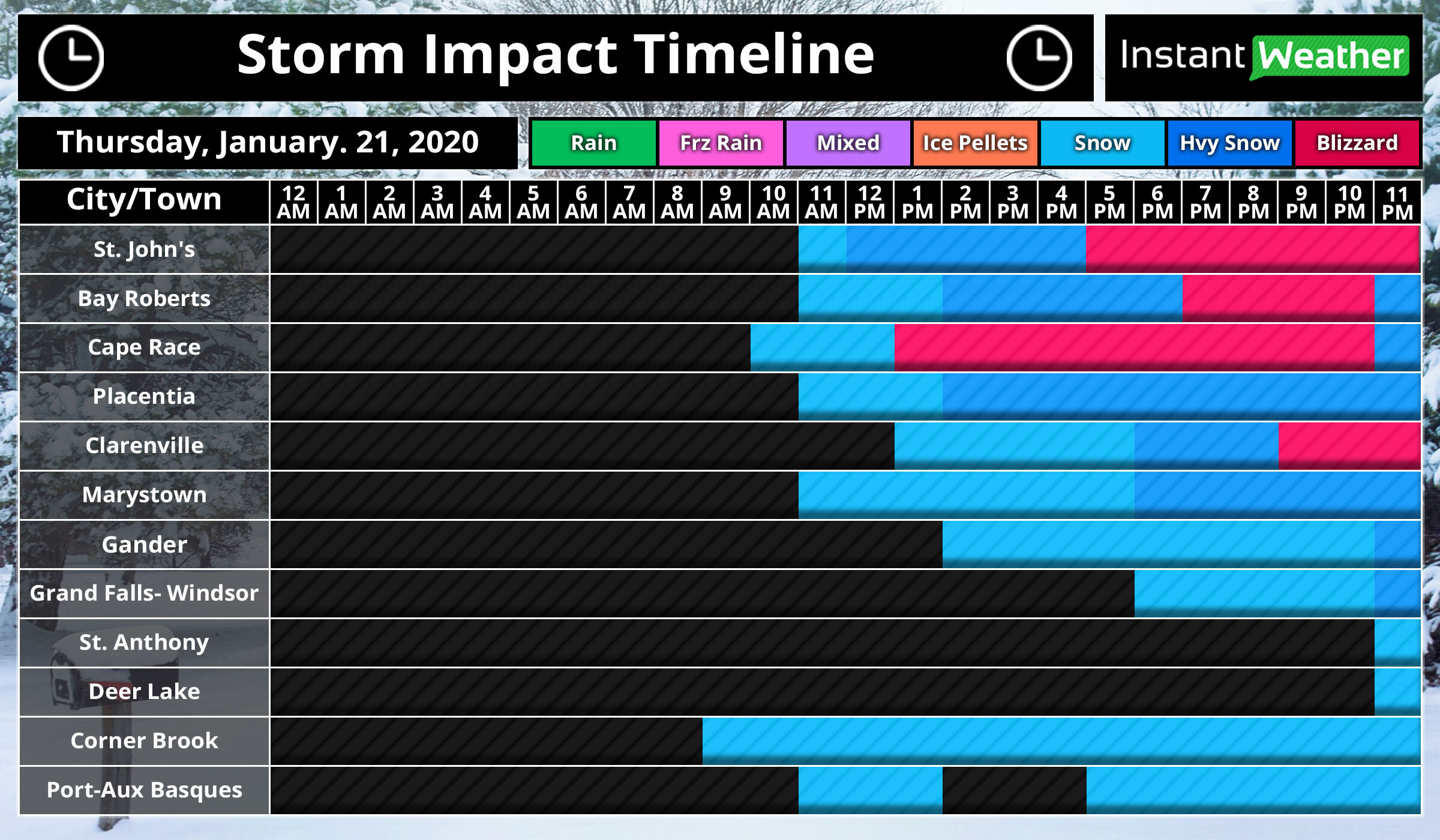
The first big snowstorm of the new year 2021 is now already approaching the province with some light snow and increasing winds, making it look lovely for now, but it’s about to look like a marshmallow world in the city! The heavy snow will quickly move in later this afternoon and evening hours, with the worst conditions between 5pm and 11pm on the Avalon Peninsula, but the moderate snow will continue through the overnight and continue into the early morning with periods of light snow still continuing to fall through the day, and even continue all the way into the weekend!
The storm has arrived on time right around the noon hour for St. John’s, we will expect that snow to quickly become steadier and heavier as the next few hours go by then it really gets bad by the time we get into the supper hour! Between 5 pm and 11 pm, we could see blizzard conditions!
The further west you go, the later the snow will arrive for you! Gander, Grand Falls- Windsor will see the snow starting later in the afternoon and early evening hours and by the time you reach St. Anthony & Deer Lake, expect the snow to not start until near 11 O’clock tonight!
On and off snow continues today for Corner Brook and Port-Aux-Basques.
As can see by the radar, and futurecast, the snow has already engulfed the entire Avalon Peninsula and will continue to spread north and west through today and tonight as it increases in intensity. You may also notice that when playing the radar, the rain/snow and mix line gets rather fairly close to the southeast near Cape Race. I wouldn’t rule out the possibility of some Freezing rain or Ice pellets in that area later this evening. If it does then snow amounts will likely be a bit lower than forecast and some tweaks to the snow map may be needed.
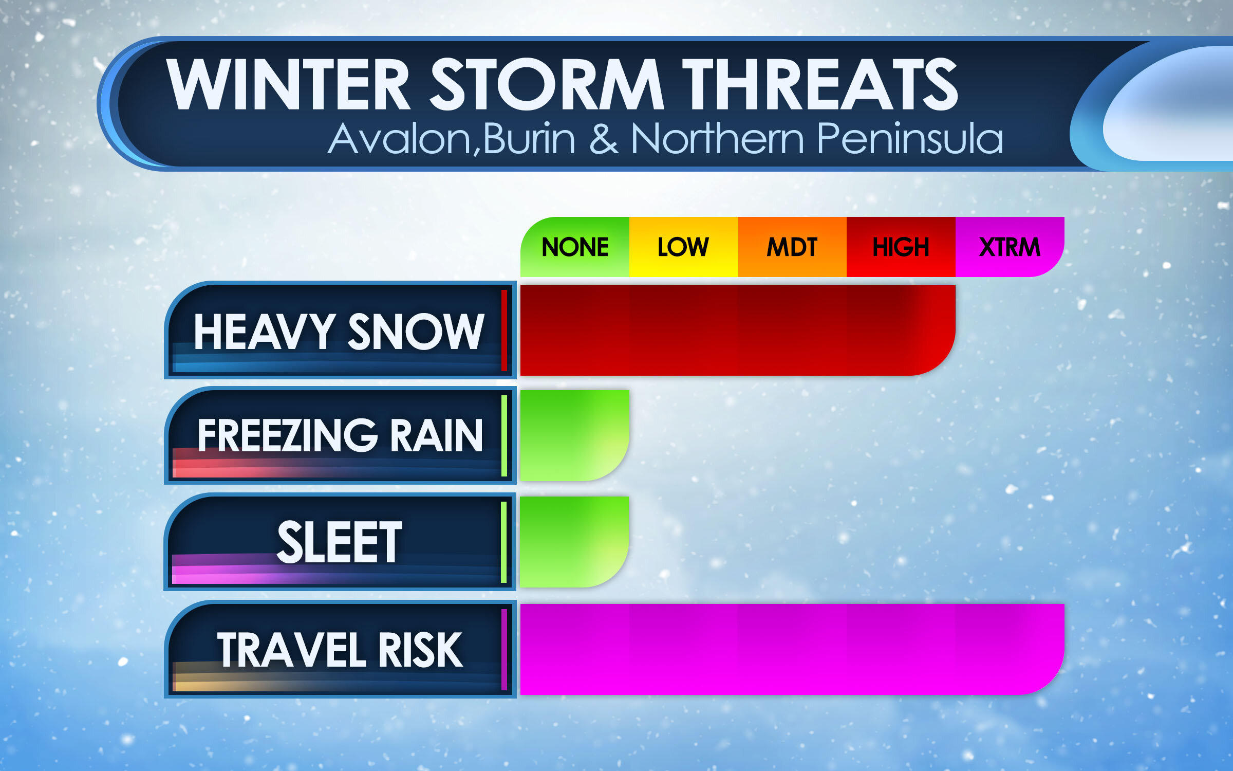
Here are the main threats with this winter storm, for the Peninsulas of Avalon, Burin and Northern Peninsula. The main threat is the Heavy snow and Travel risk! We are looking at high snowfall rates as much as 5-10cm per hour at times, many models put 40cm for St. John’s and surrounding areas. the heavy snow and combined strong wind gusts of 80-100 km/h will create blizzard conditions which will result in very hazardous travel, and for that reason the Travel Risk is at Extreme.
For Central areas, The impact is less severe as the storm will be a bit far, and the heaviest snow will miss. However, there still will be a lot of snow and strong gusty winds causing low visibility! a Moderate risk for Heavy snow, but it’s that Travel Risk that is the main Hazard! A very High Hazard, with as much as 15-25cm can fall in that area.
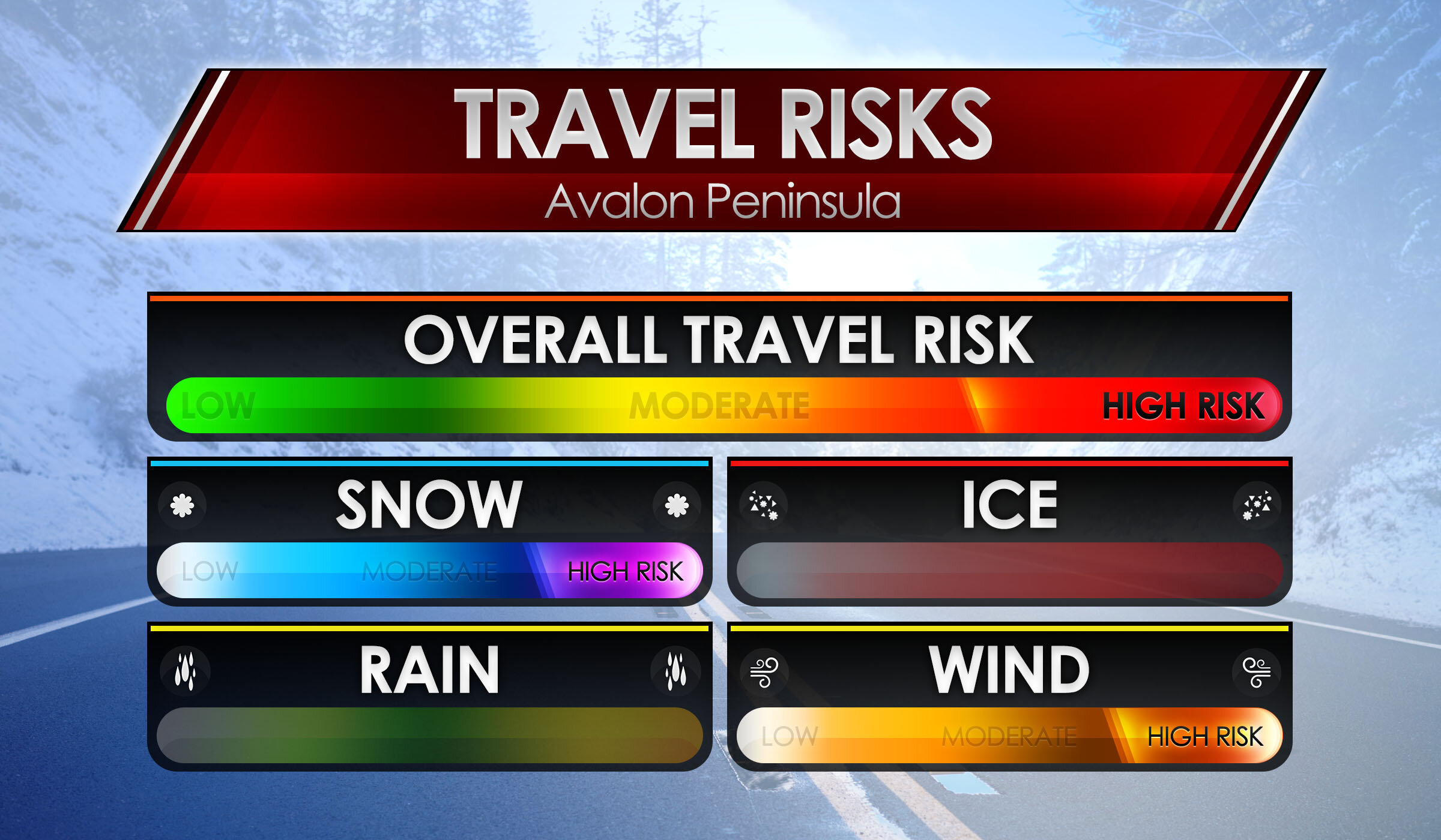
Here are the main risks for your travel risks! We’ll start with the Avalon Peninsula as that will be the hardest hit areas! Biggest risks are Snow & Wind, as we are on the colder side of the storm, snowfall amounts as much as 30 to 40cm can fall by Saturday morning! Whipped up by a high risk for winds as winds top 80-100 km/h. This will cause extensive blowing and drifting snow causing extreme low visibilities and Blizzard conditions, Overall Travel risk for the Avalon Peninsula is at High.
We now go to the Burin, Northern Peninsulas and Central for travel risks. High risk again of course for snow! snowfall amounts of up to 25cm possibly more can fall by the weekend. We also will have gusty winds, however the winds will not be as severe as the Avalon, but will be gusty and blowing and drifting snow will still be a factor, but likely not at blizzard condition level. The risk for wind is at Moderate, and that is what the Overall travel risk is, at Moderate.
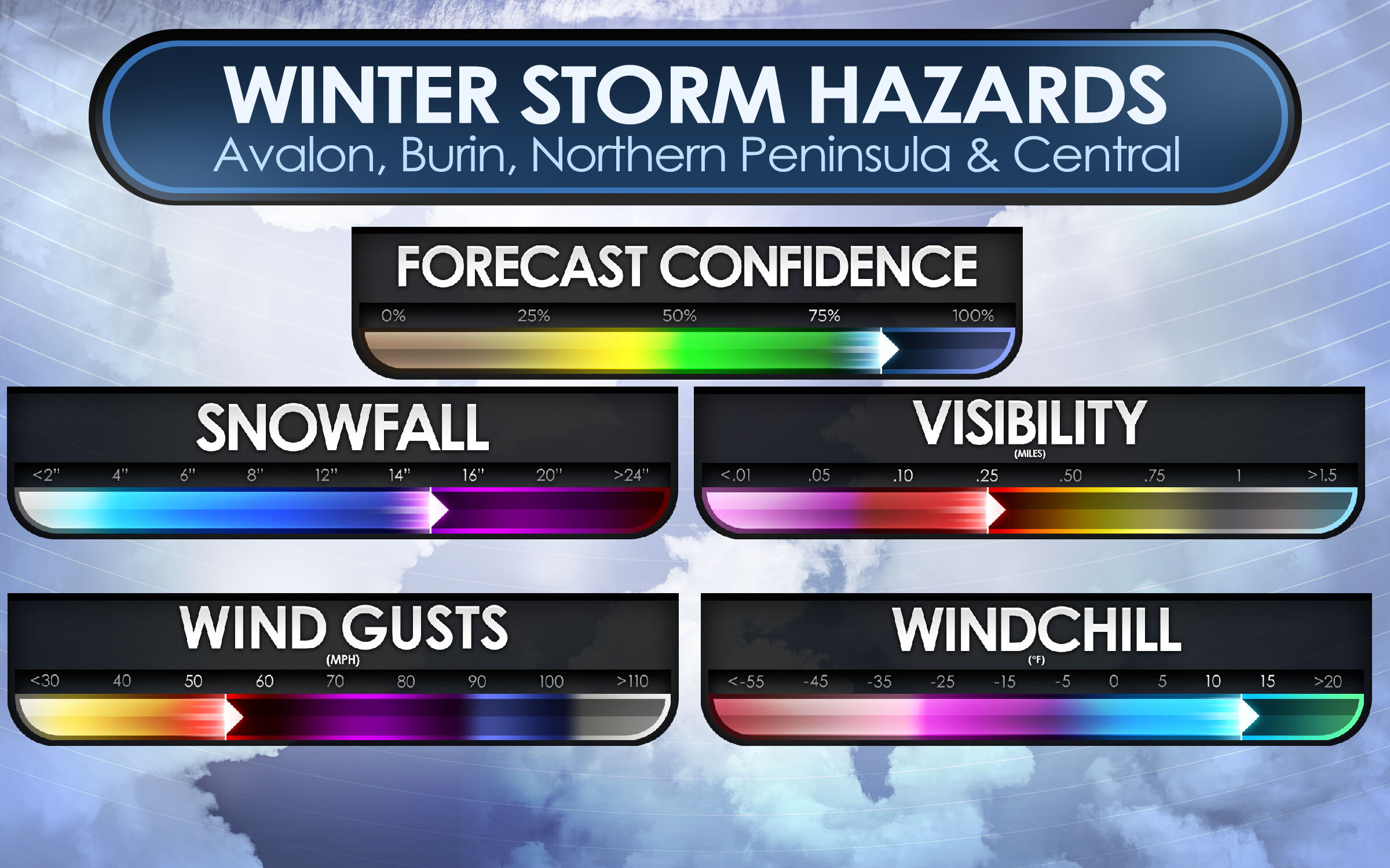
As we take a look at Threats and Travel risks, we now go to the Winter Storm Hazards! Main hazards are Snowfall, Visibility, Wind Gusts and for some, wind chill.
Snowfall: For the Avalon Peninsula, a good swath of 30 to 40cm is expected, however extreme western parts of the Avalon may see a little less in the range of 20-30cm. For Burin and Northern Avalon. as much as 10-20cm can fall and up to 30-40cm for the far northern areas. Central can see up to 25cm of snow, but lesser amounts as head south. Overall, snowfall hazards is up to 30-40cm or as much as 14-16”!
Wind Gusts: Strong wind gusts will also accompany this storm! winds of 40-60 sustained will gust to 80 to 100 km/h. this will create some property damage but most of all, the extensive blowing and drifting snow that will create white out conditions at times and blizzard conditions. Winds in the Avalon are expected to reach as high as 80 to 100 on the coast, or 50-60 mph.
Visibility: With the heavy snow and strong wind gusts, there is bound to be very low visibility… which is what is to be expected! visibility of near 0 is expected, and lot’s of times as low at 10 miles for several hours. Blizzard conditions would worsen the visibility, especially in white outs.
Wind chills: With temperatures below 0 and winds expected to clock over 40 sustained, wind chills of -10 to -15 degrees C, is likely and this could lead to a risk of frost bite. and with power outages likely, it’s a good idea to have a generator, or if have wood stove, have extra wood inside! If no generator or stove, have extra blankets and candles to try and keep warm.
Ok, let’s now go over the Forecast maps. We’ll start with the snowfall map. Starting with the Avalon! much of the eastern side will see the most with up to 40cm of snow expected including in the city of St. John’s and down to Cape Race. In the middle there is 20-30cm expected, then as get to the western side of the Avalon Peninsula, you have 12 to 20cm expected with locally up to 25cm that includes for the town of Placentia, Clarenville, and Gander. Blizzard conditions are possible for all of the Avalon Peninsula and including Northern sections from Clarenville to Gander.
For the Burin Peninsula! In the southern parts, such as Fortune and Grand Bank, you can look at only 2-6cm or locally up to 10cm. this is not a big storm for you! head north, however, towards Marystown then you will get into the higher snowfall amounts, of 6 to 12cm with locally as much as 16cm. This also covers much of the central parts of the province including Grand Falls- Windsor.
For Northern Peninsula, 12-20cm expected for Clarenville and even further amounts as head north, with up to a foot expected.
Central: not much snow expected unless going far northern central. expect 2 to 12cm with locally up to 16cm.
Western: Depends where in the west you are, the farther north you go the more snow you will get and the further south, the less you get. Stephenville, Corner Brook, and Deer Lake can see only 2-6cm with locally up to 10cm. But travel too far, far North all way up to good ‘Ol St. Anthony! then you could be talking about a good foot or more of snow!
With this storm, the strongest winds will be on the Avalon and Northern parts of the province. But mostly the Avalon!
Avalon: Winds of 70-80 km/h is the expected forecast gusts from St. John’s to Placentia, however, on the South-Eastern tip could see Gusts approaching 80-100km/h, and the extreme North-Western tip will see 60-70 km/h wind gusts, this also spreads out into Clarenville & Gander as well as Stephenville.
For the rest of the province, looking at Gusts of only 40-60 km/h, lesser winds for the Southern sections near Port-Aux- Basques.
When you have heavy snow and tropical-storm-force winds, you get the talk of power outages! Right now the Avalon Peninsula and the Northern parts of the province are at the highest risk of seeing Outages likely and even a wide swath of Widespread outages on the Avalon. Placentia, Clarenville, and Gander you can see outages likely due to heavy snow and winds. Where lesser wind and snow is expected, the outages are only possible over parts of Northern Burin Peninsula and Central including Grand Falls Windsor.
We could see some Isolated outages over the southern tip of the Burin and parts of western Central, elsewhere, there are no outages expected for tonight or tomorrow.
We will have more on this storm as we go through the day and night.
Be Safe, Be Well, Buh-Bye!!
~ James


