
Mother Nature Has Lost Her Temper
/Issued: Monday. November 23rd, 2020 @ 7:30 AM
Updated: Monday. November 23rd, 2020 @ 12:00 PM
Forecaster: James Follette

Good late morning! You will want to enjoy this gorgeous beautiful weather today because, as we get into tonight, tomorrow, and early parts of Wednesday, we are going to be bombarded with Rain, Snow, & Damaging winds.
We’ve got a Blizzard that will be occurring in Labrador with Snowfall warnings, Blizzard warnings, High Wind warnings, Wreck house wind warning, Winter storm warning, and special weather statements in effect!
A look at what to expect!

We’ll start the timing here at 5:30 PM this evening! Flurries begin to enter the Channel-Port Aux Basques, while rest of province will see increasing clouds.

By 8:30 PM this evening, we’ll see Flurries begin to develop and spread Eastward from Stephenville, Deer Lake, Corner Brook, and into Grand Falls Windsor.
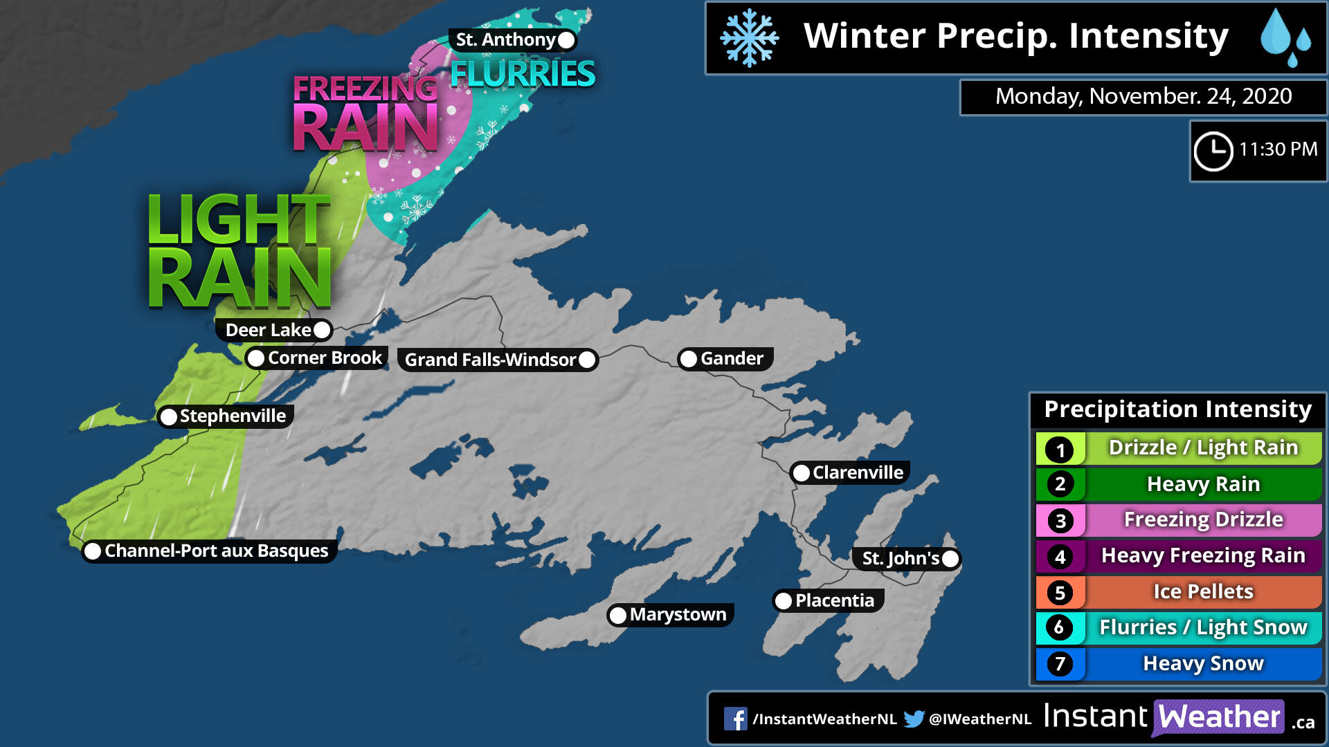
As we get into the late evening hours near midnight, we’ll see a switch to rain from the Channel-Port Aux Basques to Corner Brook, Deer Lake, and North. Further North into St. Anthony, look for some ice mix and snow flurries.

Now entering overnight hours into Tuesday morning, Rain begins to spread far west in the south from Channel-Port-Aux-Basques to Deer Lake, Corner Brook, and parts of the Northern Peninsula. A wintry mix can be expected further North on the northern most part of the province, which includes St. Anthony.

Waking up tomorrow morning on the Island, expect widespread rainfall from Channel-Port-Aux-Basques to Clarenville and Marystown. The Avalon will remain dry for the first few hours of the start of the day.
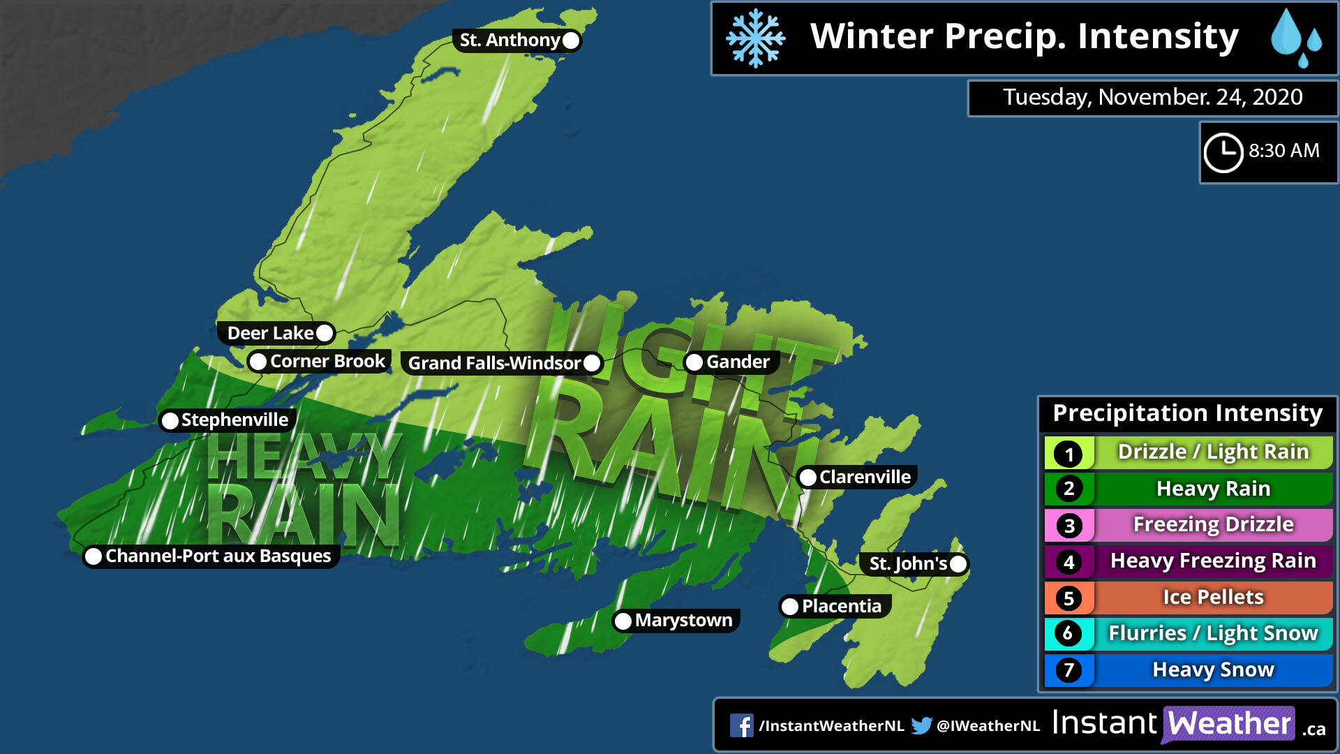
By 8:30 AM Tuesday, Rain would now have engulphed the entire Island. Light Rain from the Avalon Peninsula to Clarenville, Gander, Grand Falls-Windsor, Corner Brook and Deer Lake and up north into St. Anthony. As the Low nears and intensifies, we’ll see heavy rainfall enter Southern sections from Stephenville, Channel-Port-Aux-Basques through the Burin Peninsula in Marystown and south-western sections of the Avalon Peninsula such as Placentia.

By time it is near Dinner time, and you have your chili put on or your fish that you caught, there will be heavy rain over much of the entire province. Exception will be Gander and Northern parts of the Island through St. Anthony.

As we enter Tuesday Afternoon, Heavy rain will now change to snow for Western sections from Deer Lake to the Channel-Port-Aux-Basques, a dry break East of there. heavy rain tapers to light rain for Northern Peninsula and Burin Peninsula. however we will continue to see heavy rainfall continue into the Avalon Peninsula.

By Supper hour, much of the system has exited, some left over remaining showers for Northern Avalon Peninsula, including St. John’s, and Northern most part of the province up towards St. Anthony. Snow will continue into the western parts of the island. from the Channel-Port-Aux-Basques to Deer Lake and a bit further up. Corner Brook is included in this.

By 8:30 pm in the evening, we can expect snow over Western sections to continue, areas of Grand Falls-Windsor eastward, will see clearing conditions. But that snow in the west will stick around through much of early Wednesday morning, which is why we do have the higher snowfall numbers in that area.
Monday Storm Timeline

Nothing much to be expected today with the exception of rain beginning in Corner Brook & Port-Aux-Basques.

Now Tomorrow is an all different story together! Depending on where you are, you could have a quick storm or a slow and punishing storm.
Rain will begin in the Avalon Peninsula by early Tuesday morning on the capes around 4 or 5 am but not in the capital city of St. John’s until 8 am. Northern Peninsula will see rain begin near 7 or 8 am. West coast is where all the action is! Rain continuing to fall through tonight all the way into 11 am in Corner Brook where it will then change to snow then heavy snow later in the evening. Rain continues and changes to snow in the Channel-Port-Aux - Basque at 11 am and continues through the night hours of Wednesday.
St. Anthony will start off as some Mixed precipitation and Ice pellets ( Sleet) then change to rain by 4 am and snow as of 7 pm tomorrow evening.

By Wednesday morning while much of the island is cleared off, Snow will still continue to fall over western sections. through at least 5 to 8 AM. For, Corner Brook, Port-Aux-Basques & St. Anthony.
Rainfall Amounts

Rainfall will be heaviest over Southern sections, Burin Peninsula and the Avalon Peninsula.
Avalon Peninsula can expect upwards of 30 mm with local amounts up to 40 mm.
Burin Peninsula can expect a little less rainfall, with amounts of 5 to 10 mm however up to 20 mm in local areas are likely.
Northern and Central from Gander to Grandfalls-Windsor, amounts of 5 to 10 mm, local amount of up to 20 mm
South West Coast. the highest rainfall with 50 to as much as 70 mm of rainfall. Elsewhere 30 to 50 mils can be expected.
The Snow! Blizzard & Blowing snow

Along with Rain is the heavy snow to the west!! A big chunk of the Island will only see a dusting to 2 cm, but winds will persist and strong enough to create blowing snow. Channel-Port-Aux-Basques and northward, as much as 12 cm, with local amounts up to 15 cm. Stephenville, Corner Brook, Deer Lake, as much as 20 cm of snow can fall by Wednesday morning.
Strong winds will give Blizzard like conditions for much of the Western portions of the Island.
For Labrador… Blizzard warnings are in place for what will be an epic monster snowstorm. Winds of 90-120 km/h and snowfall amounts of 2-4ft! drifts could be as high as 5-7ft! Travel is expected to be nearly impassable, widespread power outages are expected and plenty of wind damage as well for much of Labrador.
The Powerful winds! Tropical Storm to Hurricane Force!

The biggest story with this storm is the winds! many wind warnings are in place!
Avalon Peninsula can see winds exceeding 110 km/h and as high as 120-130 km/h. exception will be the northwest parts of the Avalon Peninsula where winds gusting to 105 km/h is expected.
Burin Peninsula can expect 90 to 115 km/h Gusts, East of Marystown winds will likely exceed 110 km/h.
Central portions of the province can expect wind gust to be 90-105 km/h
Northern portions of the province can expect 80-95 km/h wind gust from Gander to GrandFalls-Windsor.
Farthest Northern section of the Province towards St.Anthony, wind gust of 90-105 km/h is expected including in St.Anthony, West of St. Anthony wind gusts are very likely to exceed 110 km/h.
Western Portions, wind gust will be very strong! with Gusts as high as 120-130 km/h towards Port-Aux-Basques. and 100-115 km/h from stephenville, Corner Brook and towards Deer Lake.
