
Messy Winter Storm With Prolonged Freezing Rain Risk To Impact Nova Scotia on Tuesday
/
The same storm that has brought record-breaking winter weather to much of the US is expected to also affect Nova Scotia throughout the day on Tuesday. The current track of the low-pressure system puts it right across the central part of the province so unlike the last storm which we were on the cold side, this one will be quite a mess starting off with some snow, ice pellets and freezing rain early Tuesday and transitioning over to rain as temperatures climb above the freezing mark.
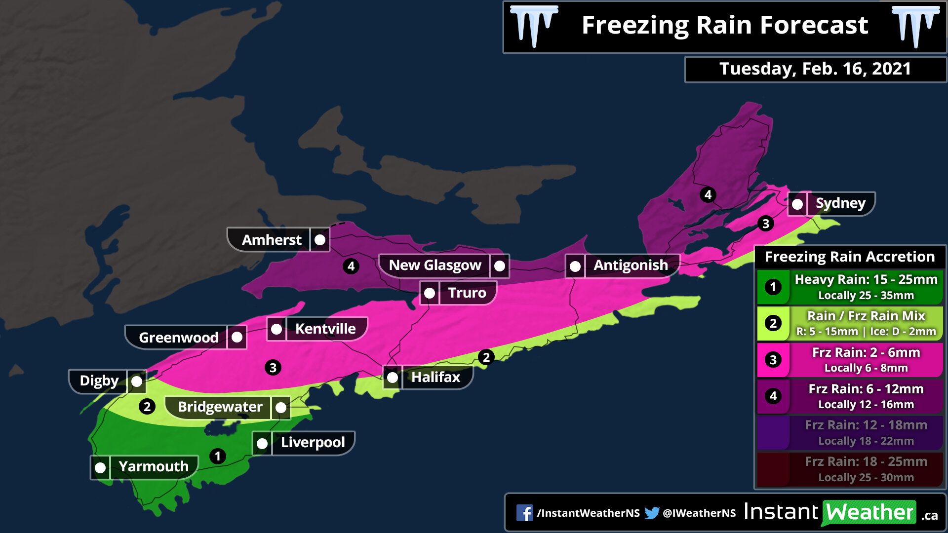
The freezing rain risk is expected to be more prolonged further to the north and inland from the shoreline. Ice accretion could range from 6 -12mm in the hardest-hit regions which may result in hazardous driving conditions and localized power outages. Conditions will improve later in the day on Tuesday as all areas switch over to rain with temperatures into the mid to upper single digits by the evening.
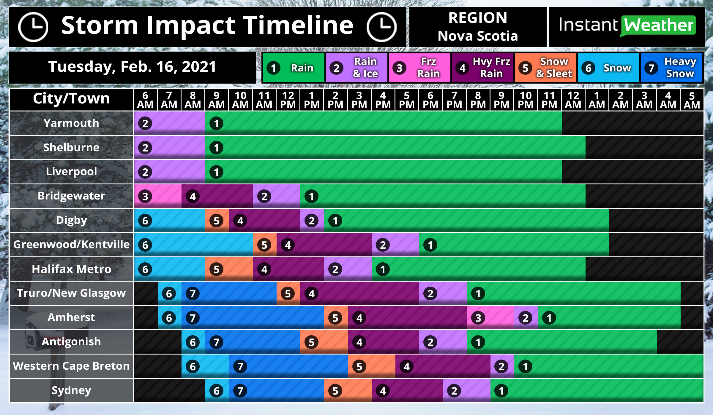
The first bands of precipitation associated with this system will reach the southern part of the province just before sunrise on Tuesday. For the Yarmouth and Shelburne area, a few hours of freezing rain is possible before a switch over to rain later in the morning. Areas further to the north including Digby, Greenwood/Kentville and Halifax will see some light snow to start off the morning with some ice pellets and freezing rain mixing in during the late morning and heavier freezing rain for a few hours.
Northern Nova Scotia such as Amherst, Antigonish and Cape Breton could see a few hours of heavy snow during the morning - especially in the Amherst area may accumulate with up to 10cm of snow. They will transition over to the heavy freezing rain during the mid the late afternoon hours. This freezing rain may be quite intense and times with very poor conditions through the northern part of the province.
By the evening, it will feel like a whole different season as warmer temperatures take over across the province and putting an end to any of the wintery precipitation. Some parts of the southern part of the province may even flirt with the double digits during the early overnight hours. Rain will continue overnight will slowly tapering off as the system moves out over Newfoundland.
Accumulation from the morning snow will fairly insignificant considering it will be washed away by the rain, but wouldn’t be surprised to see up to 5-10cm around the Amherst area. The rest of Nova Scotia will see a few centimetres max. The main story of this system will be the potential prolonged freezing rain risk through the northern part of the province. Between 4-8 hours of persistent heavy freezing rain could lead to a fairly significant ice build-up through Amherst, Truro, New Glasgow and Western Cape Breton. Maximum ice accretion of between 6-12mm and maybe locally up to 15mm is expected in this region.
Other areas away from the shoreline could see a few hours of heavy freezing rain with around 2-6mm of ice accretion - this may include the Halifax Matro region, but they’re right on the line. Southern parts of the province will see minimal freezing rain with predominantly just heavy rainfall. Speaking of rain, totals between 10-25mm are possible with locally up to 35mm in the Yarmouth region. Between 5-15mm of rain is possible after all the freezing rain for the rest of the province.
