
Potentially Strongest Snowstorm in Years To Bring Up to 20-40cm of Snow to Parts of Southern Ontario Starting Sunday Night; Localized Blizzard Conditions Possible Monday Morning
/
For several days now we’ve been monitoring an impactful system that is expected to bring heavy snowfall to parts of Southern Ontario starting late Sunday. Although there has been a significant amount of disagreement with the exact track of this system amongst the different weather models which have made it hard to give a precise forecast until now.
It was possible that the system could track further east and miss much of our region, but we’re just over 24 hours from the beginning of the event and confidence is growing in the general track of the system. That track has shifted even somewhat further to the west compared to the data we were using in our preview forecast on Friday. As a result, we have now pushed the significant snowfall accumulation of 15+cm to include much of the Golden Horseshoe and into regions east of Lake Simcoe.
This storm is shaping up to be possibly the most impactful snowstorm for parts of Southern Ontario that we’ve seen in several years. Of course, there isn’t much competition as the last few winters have been fairly quiet when it comes to major storms. This storm is special in particular as it’s uncommon for locations outside of the traditional snowbelt in Southern Ontario to see up to 40cm in such a short timeframe.
The intensity of the snowfall (approaching 4-8cm/hour) at the height of this event early Monday morning will lead to rapid snowfall accumulation and a significant impact to travel. Strong wind gusts ranging from 40-60km/h combined with the heavy snow will likely result in blowing snow and localized blizzard conditions during the morning on Monday. It’s almost certain that we see widespread school bus cancellations and school closures just as students return to in-person learning on Monday.
It’s important to note that the track could still shift by a few kilometres even within 6-12 hours before the start of the snow so this will be the one event where what we call ‘nowcasting’ is very important. Adjustments to the expected accumulation may need to be made up to a few hours before the event starts.
That few kilometres might not seem like a big difference and with most systems, it generally doesn’t make a difference. However, this system has a very tight snowfall gradient where the difference between 5cm and 40+cm could be a matter of a few dozen kilometres. We have included the zone on our map (shown in the white hatched circle) where we are less confident in the exact accumulation due to the tight gradient and could go up to down a level on our legend in a future update.
The higher confidence for this system is in the far eastern and western edges of our forecast where the exact track won’t significantly change the forecast. Just keep in mind that this is far from set in stone and don’t be shocked to see some changes on Sunday based on the latest data. We should hopefully have a better idea by Sunday afternoon and even then some last-minute shifts in the track are possible.
Regional Timing
TIP: You can click on either timeline graphic to open a zoomable version of the graphic.

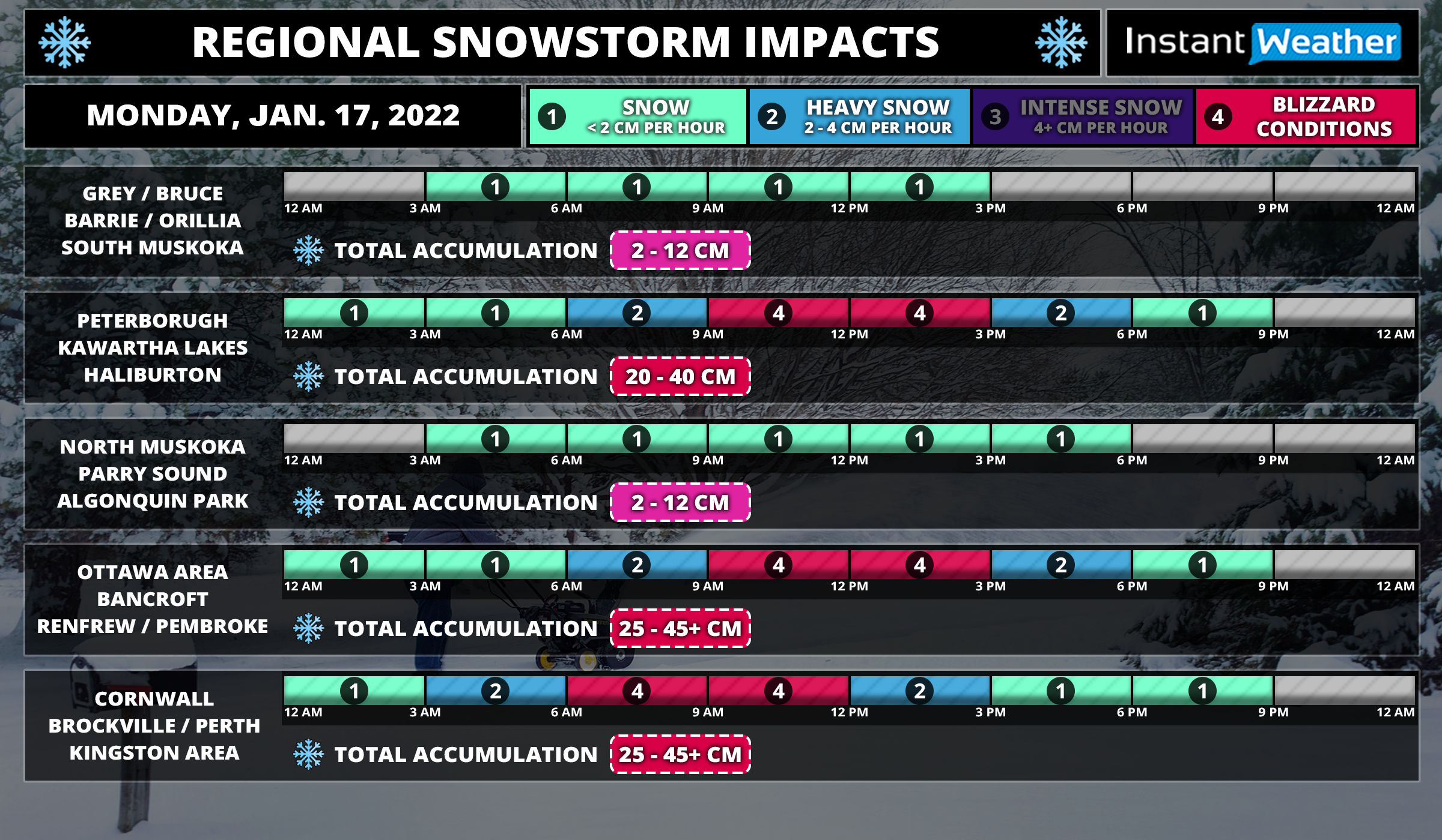
The first bands of precipitation from this system will begin to affect areas around Lake Erie late Sunday evening close to the midnight hour including the Niagara Region and GTHA. The snow will be quite light for the first few hours, but don’t let that fool you! It will quickly pick up in intensity later in the overnight hour as the centre of the low tracks up the US East Coast. The heaviest snowfall will occur during the mid to late morning hours on Monday which is probably the worse timing for the morning commute. This is when there is the risk for blizzard-like conditions and blowing snow as the winds pick up around sunrise on Monday.
Eastern Ontario and parts of Central Ontario will see snow starting overnight with the worst conditions during the late morning and early afternoon on Monday. Refer to our timeline graphic above for more precise timing information for your region and on when to expect the heaviest accumulation.
We should begin to see the snow clear out starting with those further west by the late morning hours in Southwestern Ontario. The clearing will happen during the mid to late afternoon for much of the GTA and into Central Ontario. Eastern Ontario will continue to hold onto the heavy snow past the dinner hour before tapering off by midnight.
Potential Snowfall Totals
The most difficult aspect of this system to forecast will be the potential accumulation that each location receives by the end of the event. As we’ve mentioned above, this is due to the tight gradient that may even result in one side of a particular town or city picking up way more snow than the other side. What we can say with a high amount of confidence is that those in the Niagara Region and much of Eastern Ontario will see the most snow from this storm. Accumulation here will range from between 25-40cm with a zone including St Catharines, Kingston, Smiths Falls and Ottawa that could see locally as much as 50cm.
This will be different from the usual snowfall events that extend 24-36 hours which would lessen the impact. Instead, the bulk of the snowfall will come within a 6-12 hour timeframe and as a result, it’s unlikely that road crews will be able to keep up and travel should be avoided for much of Monday. Just plan to stay home in the hardest-hit regions if possible.
Once we go further west, the confidence in the exact snow totals decreases which includes Brantford, Hamilton, GTA, K/W, Barrie and up into Central Ontario. Right now we have accumulation here ranging from 10-30cm which may seem like a fairly large range, but it’s reflective of the tight gradient which could shift around. We feel it’s important to be transparent in this instead of forcing ourselves to narrow down the range even more which would lead to an inaccurate forecast. You can still look at the accumulation range for your location on that map, but it should be taken with a grain of salt if you are also in the ‘uncertain’ zone as it might go up or down a category on our legend.
And finally, we can say with a fair amount of confidence that areas roughly northwest of a line from London to North Bay shouldn’t see much snow from this event. This includes Extreme Southwestern Ontario (Windsor, Sarnia) and along the Lake Huron shoreline. London up through Barrie and into Muskoka will be right on the edge and can expect to see around 5-15cm with lower amounts further to the northwest. Later on Monday, we will have to watch for the potential for some lake effect snow developing off Lake Huron and Georgian Bay as the storm moves out. Right now, it’s not looking particularly significant, but that can change. More details as we get closer to Monday
Stay safe! If you’re prepared for this storm, there’s nothing to worry about! Just be careful and try to avoid travel on Monday if you can. It will be over by the end of Monday except for the lake effect snow and the conditions will improve as we head into Tuesday. Be sure to check back on Sunday if we need to make updates to this forecast based on the latest data.
