
Southern Ontario: Special Winter Weather Hazards Outlook
/
Forecast Discussion
There are no current special outlooks for Southern Ontario.

We are in for quite the wild ride when it comes to the weather across Southern Ontario over the next few days. The active weather will begin on Sunday as a system ushers unseasonably warm air into the region which will result in many areas seeing temperatures reach into the double digits for early Sunday. However, this blast of warm air will be accompanied by rain and even non-severe thunderstorms mainly during the morning on Sunday. We aren’t expecting a significant amount of rain so flooding shouldn’t be a major concern, but areas that experience thunderstorm activity could see locally higher rainfall totals. Looking at general rainfall totals ranging from 5-10mm with locally 10-20mm in those locations that see the thunderstorms.
The biggest story from this system will certainly be what is shaping up to be a potentially significant wind storm across Southern Ontario. These strong wind gusts will start to pick up in Southwestern Ontario just after midnight and continue to persist throughout the morning on Sunday. Later in the morning, we will see the damaging wind gusts expand further to the east including the Golden Horseshoe and into Eastern Ontario. We expect the worst of this wind storm will be felt during the late morning and early afternoon with the winds weakening later in the day as we head into the evening hours.
Current indications suggest that the strongest wind gusts will be found through the Niagara and Hamilton region. Especially around the Grimsby and Niagara-on-the-Lake area that borders the Lake Ontario shoreline. We believe that wind gusts here could exceed 110km/h at the height of the event and potentially even approach the 115-125km/h range. This could result in very severe wind damage throughout the region including the possibility of power outages. Be sure to secure anything on your property that could be blown away!
Those around the Lake Ontario and Erie shoreline along with through the higher elevations of the Dundalk Highlands can expect wind gusts of between 90-110km/h. This includes Deep Southwestern Ontario (Windsor, Chatham and London) along with the K/W, GTA and Kingston regions. The rest of Southwestern Ontario into parts of Central/Eastern Ontario are looking at wind gusts ranging from 85-95km/h. Less of an impact when it comes to the strong wind gusts are expected further to the north and west including Algonquin Park, North Bay and Sudbury which will still see strong wind gusts but shouldn’t reach severe levels.

As mentioned, this system will temporarily boost the temperatures across Southern Ontario with the warmest air from Windsor through London and around the GTA. The daytime temperature here will range from 14 to 18°C and we can’t even rule out one or two locations even flirting with the 20s, but it’s questionable.
Don’t expect these warm temperatures to last all day as the daytime high will likely be hit sometime during the late morning or early afternoon and quickly drop back into the single digits later in the day. The rest of Southern Ontario except for northern parts of Central Ontario and Northeastern Ontario will see a daytime high in the low to mid-teens.
This will be short-lived as below-freezing temperatures will return to much of Southern Ontario by Sunday night! The drop in temperature to below freezing appears to be fairly gradual so a flash freeze shouldn’t be a threat, but that could change. However, we are watching what could be an impactful winter storm across Southern Ontario on Monday and Tuesday. This also includes the risk of prolonged freezing rain for a large portion of the region. More details on that are to come on Sunday once the exact impact is more certain.

There will also be a cold side to this system, but for the most part, the wintery precipitation will stay to the north of Southern Ontario. Although there is a brief risk of freezing rain during the very early morning hours on Sunday for Northern Central Ontario and into the Ottawa region. This will quickly come to an end as temperatures rise well above the freezing mark later in the morning. More prolonged freezing rain is expected through Northeastern Ontario including Elliot Lake, Sudbury and North Bay. See our Northern Ontario forecast for more details on the impacts this system will have there.

A messy Tuesday is ahead for much of Southern Ontario as a potent system moves through the region bringing the threat of prolonged freezing rain. This will all begin early Tuesday morning as we see the first bands of precipitation work into Southwestern Ontario just after midnight tonight. For Southwestern Ontario and the Golden Horseshoe, the story with this system will be heavy rain as temperatures will be above the freezing mark by the time the rain arrives. Between 10-25mm of rainfall accumulation is possible in those regions which could result in some localized flooding. There is even the outside chance of a non-severe thunderstorm for Deep Southwestern Ontario including Windsor and Sarnia!
This precipitation will encounter colder air further to the north along with the higher elevations of the Dundalk Highlands to the northwest of the GTA. This will allow for the risk of some freezing drizzle of rain for a few hours during the mid to late morning hours. It should transition over to rain by the early afternoon as temperatures slowly climb above the freezing mark. Expect an icy morning commute for locations like K/W, Guelph, Orangeville, Barrie and Peterborough.
The main concern with this storm will be through Central and Eastern Ontario where the cold air appears to be more entrenched and leading to a prolonged period of freezing rain. This begins late Tuesday morning which could start as some snow or sleet for the more northern regions and slowly mix in some freezing rain as we head into the afternoon.
We have fairly high confidence in the potential for 12+mm of ice accretion in a zone that includes Tobermory, Parry Sound, Sundridge and Algonquin Park. The Ottawa Valley and Northern Muskoka can expect around 6-12mm of ice accretion. However, there is lower confidence further south which includes Bracebridge, Kawartha Lakes and Smiths Falls as some models show a faster warmup while others are slower. If temperatures do indeed take longer to warm up, this would result in a bigger impact on that region. For now, we’re going with 2-6mm of ice accretion, but keep an eye on that local range of 6-8mm should the cold air be more stubborn than expected.
The freezing rain threat should come to end later in the evening on Tuesday. There are some indications that a few areas including Tobermory, Algonquin Park and the Ottawa Valley may not even see above freezing temperatures before colder air floods into the region late Tuesday. This means that the locations that are hardest hit by the freezing rain might continue to be impacted by the ice accretion for days to come. It’s not out of the question that this approaches ice storm levels for that 12-18mm zone so be prepared for extended power outages and disruption to travel that could linger into Wednesday.
There is also the risk of a flash freeze throughout Southern Ontario early Wednesday morning. All that rain from this storm plus melted snow will make for icy road conditions as the temperature drops. There is some uncertainty regarding the exact speed of this cooldown which would dictate how impactful the flash freeze could be.

Turning towards Northern Ontario, this system will be more of a snowstorm for Northeastern Ontario starting early Tuesday morning and continuing into Wednesday. Sleet and freezing rain are possible around the Georgian Bay shoreline including Sudbury and North Bay which would help reduce the potential snowfall totals.
A fairly expansive zone that includes Thunder Bay through much of Northeastern Ontario like Maraton, Chapleau, Timmins and Cochrane will see around 20-30cm of snow from this storm. Locally higher totals closer to 35cm or even 40cm can’t be ruled out either. Accumulation will drop off further to the north where less moisture will be present and to the south where mixing is possible. The Sudbury and Kapuskasing region can expect between 10-20cm of snow. While North Bay should see around 5 -15cm of snow along with several hours of heavy sleet or freezing rain.
Blowing snow will also be an issue with wind gusts ranging from 40-60km/h making for difficult driving conditions. We should see an improvement after Wednesday morning as the system moves out of the region. If possible, try to avoid travel until Wednesday as it’s quite possible that this storm will lead to highway and road closures through Northeastern Ontario.

After a fairly mild day across Southern Ontario on Wednesday, that will be coming to an end as an impactful system is set to dump up to 15-30cm of snow between Thursday and Friday. Earlier data indicated a more northern track which would have resulted in a fairly expansive freezing rain and even an ice storm threat. It appears the storm will indeed track further south with the colder air encompassing more parts of our region and making this a snowstorm for most locations. The Niagara region along with Prince Edward County and Kingston are the only exceptions to this which is still on track to see several hours of freezing rain.
The worst conditions are expected during the late afternoon on Thursday starting in Southwestern Ontario and continuing through the evening and early Friday morning. A very intense band of snow will work its way through the Sarnia, London, K/W, GTA, Peterborough and Ottawa corridor late Thursday which could bring hourly snowfall rates between 4-8cm for several hours. As a result, rapid snowfall accumulation is expected and will feel very reminiscent of the blizzard that dumped over 50cm of snow in the span of 6-8 hours exactly one month ago to the data as of Thursday.
The moisture associated with this system won’t be as intense as what we saw a month ago so snowfall rates exceeding 10cm are unlikely. Along with mixing and ice pellets being more prevalent with this system will help reduce potential accumulation. However, the immediate impact of this storm probably won’t be that different from what we saw last month because it’s impossible for road crews to keep up with the rapid accumulation. The long-term impact shouldn’t be as significant since 15-30cm of snow is the maximum that we’re going with which is around half of what the last storm delivered for many areas. It should allow for a faster and more efficient cleanup.
There is also the threat of a few hours of blizzard conditions with 30-60km/h wind gusts and very intense snowfall rates. Now, it might not meet the official criteria for a blizzard according to Environment Canada which requires blizzard conditions that last 4 hours or longer, but a few hours can still make travel near impossible during that time. Travel should be avoided starting late Thursday and if you can, stay home on Friday as many roads will likely still remain snow-covered. School bus cancellations and school closures are almost certain for Friday and some areas could even see them on Thursday due to the risk of freezing rain early in the day.


TIP: You can click on either timeline graphic to open a zoomable version of the graphic.
We’ve already begun to feel the impacts of this system with heavy rainfall occurring Wednesday evening and will continue into Thursday morning. General rainfall totals will range from 10-25mm across Southern Ontario (Note: we have only included rainfall totals occurring after 6 am in the graphics above - although almost everyone will see heavy rain late Wednesday and overnight).
The first threat associated with this winter storm will play out just after sunrise on Thursday as cold air starts to flood into Southern Ontario from the northwest. This will push temperatures below the freezing rain starting with Central and Southwestern Ontario during the morning on Thursday. Due to the previous rainfall and melted snow, it’s quite likely that we see icy conditions developing on roads so be sure to drive very carefully on Thursday.
The cooldown thankfully appears to be more gradual over the span of 3-6 hours instead of a rapid drop so a traditional flash freeze is unlikely. This will continue to spread to the southeast throughout the day reaching the GTA by the early afternoon and Eastern Ontario by the mid to late afternoon.
As the cold air causes temperatures to drop, we will also see the rain slowly transition over to an hour or two of freezing rain and ice pellets before snow takes over. The exact switch over for each region is outlined in the regional graphics above, but it will occur sometime during the late morning and afternoon depending on your location.
The snow will likely start off quite light and there might even be a short break during the afternoon on Thursday before the second push of moisture moves into the region by the dinner hour. This second round will come in the form of snow as we expect most areas to have cooled down enough. A slower cool down could result in more ice pellets mixing in from Windsor, through the GTA and into the Ottawa Valley during the early evening. Depending on the extent of this slowdown, it could significantly reduce the potential snow totals in those regions so keep in mind the forecasted totals are conditional on that.
For the Niagara region and a small area around Kingston, it looks like the colder air could get stuck which would allow for the development of a fairly extensive band of freezing rain. Significant icing is possible for the aforementioned regions starting late in the afternoon and continuing past midnight. This of course will depend on the exact temperatures and if it’s slightly warmer it could come down as regular rain or slightly colder would mean more ice pellets or snow.
As mentioned, this wave of precipitation will bring very intense snowfall rates of 4-8cm per hour during the evening hours. That combined with the strong wind gusts will result in localized blizzard conditions and blowing snow. It will only last for 2-3 hours max, but during that time it will be almost impossible to travel anywhere so PLEASE stay home if you can late Thursday.
Conditions will improve overnight and early Friday morning as the snow becomes less intense and the system moves out of the region. We do expect a significant impact on the Friday morning commute as it’s unlikely that most roads will be cleared of snow by then so continue to stay home if you can.

By the time the snow tapers of early Friday, we are looking at widespread snowfall accumulation ranging from 15-30cm including Windsor, Sarnia, London, K/W, Toronto, Peterborough and Ottawa. A few localized totals could exceed the 30cm mark especially if temperatures end up slightly colder and allow for higher snow ratios. Mixing along the southern edge of this zone including Windsor and Hamilton could also decrease snowfall totals if the switchover is delayed.
For those along the Lake Erie shoreline and into the Niagara region, we are looking at between 5-15cm of snow along with the freezing rain threat with the snow coming predominantly early Friday morning after the switchover. Totals will also drop off further norther with between 10-20cm of snow extending from Goderich through Barrie, Southern Muskoka and Pembroke. The Bruce Peninsula and Parry Sound/Northern Muskoka are can expect around 5-15cm (likely closer to the lower end). Little to no impact is expected for Northeastern Ontario as this will be contained to Southern Ontario.
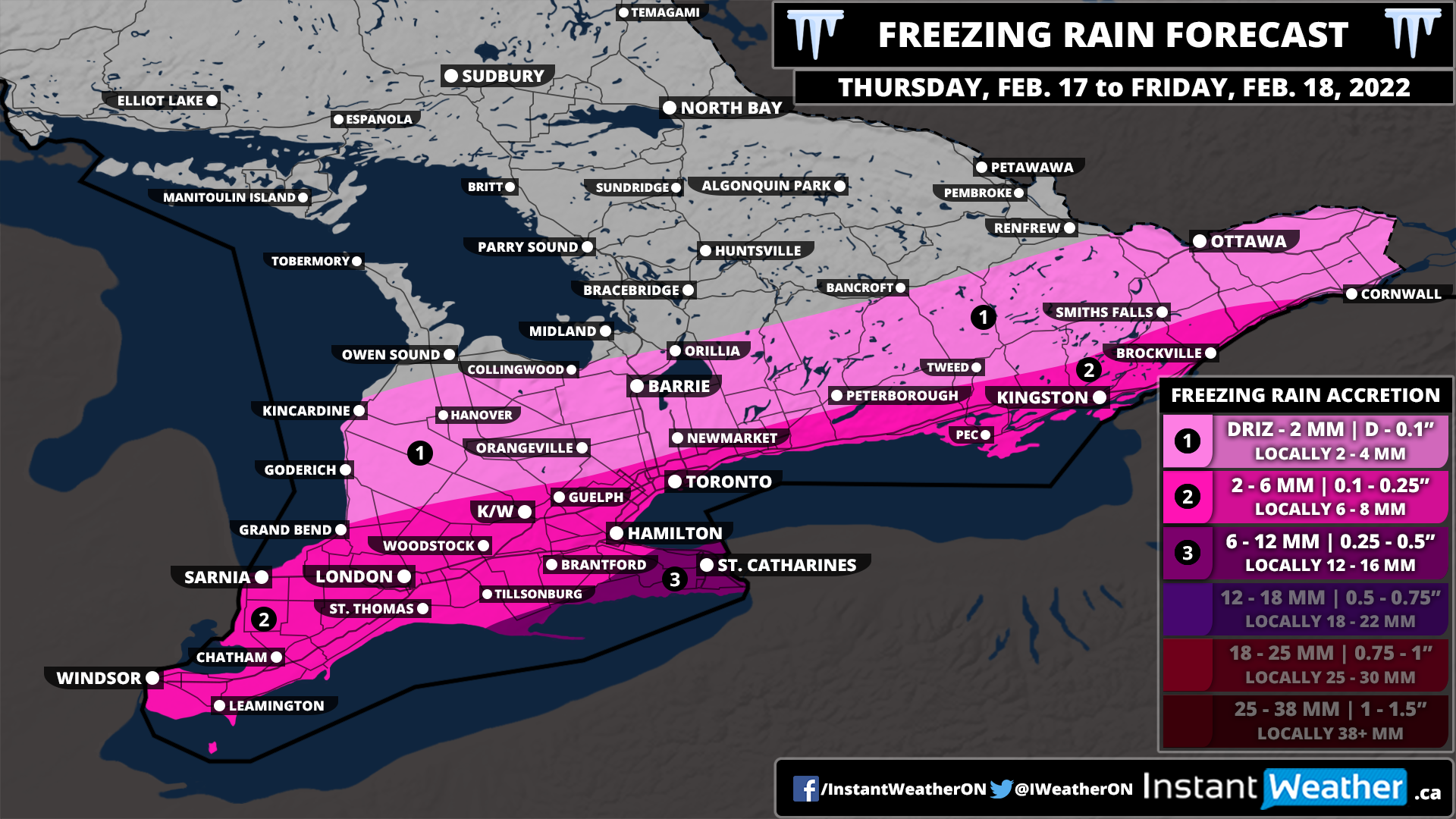
The focus of the freezing rain will be on the Niagara Region including St. Catharines and Niagara Falls late Thursday and Friday morning. Total accretion here could range from 6-12mm with locally as much as 15mm if it ends up lasting longer than expected. Kingston and Prince Edward County will likely end up somewhere around 4-8mm so we haven’t included them in the higher zone. The rest of the affected regions can expect a few millimetres of ice accretion during the switch over mid-day Thursday.
Keep in mind that this isn’t a typical freezing rain event which is usually followed by a warm-up and any ice to quickly melt. This event will be followed by another drop in temperature later on Friday and will stay below the freezing mark going into next week. Power outages are possible in the affected region and could even continue to linger into the weekend as the ice adds continued stress on power lines and trees. Be sure to charge up all your devices and be prepared for power outages.

We’re in for a wild rollercoaster ride over the next few days across Southern Ontario when it comes to the weather. This is thanks to a complex system that is expected to become even stronger as it pumps Gulf of Mexico moisture into our region between Wednesday and Friday.
It will all begin early Wednesday morning as we see a steady rise in the temperature bringing all of Southern Ontario well above the freezing mark throughout the day on Wednesday. We are talking about fairly unusual temperatures for this time of the year with daytime highs potentially approaching the upper single digits. It’s possible we may break some temperature records on Wednesday as the record high for most locations range from 3-9°C which is quite likely to be surpassed on Wednesday.
The rise in temperatures across the region will also be accompanied by some very strong wind gusts developing Wednesday morning and continuing into the afternoon. We expect the strongest gusts will be found along the Lake Huron shoreline and through the Niagara Escarpment stretching from Collingwood down into Hamilton. Damaging wind gusts ranging from 90-110km/h are possible in those regions which could result in power outages.
The rest of Southwestern Ontario, around the Golden Horseshoe and east of Georgian Bay can expect wind gusts to max out at around 85-95km/h with power outages also possible. Eastern Ontario and Central Ontario will see slightly lower wind gusts maxing out at somewhere between 80-90km/h, but that certainly isn’t weak so expect some minor wind damage even though they aren’t in the strongest zone.

The wind storm threat should die down as we head into the evening on Wednesday and the first wave of moisture from the system moves into Southern Ontario. This first round will predominately come down in the form of rain as temperatures will remain mild overnight. Those in Northeastern Ontario could see some snow instead of rain as the warmer air likely won’t reach that far north with 5-10cm of snow possible.
Overall we are looking at widespread rainfall accumulation by the Thursday morning/afternoon to range from 10-30mm across Southern Ontario. It appears that Southwestern Ontario and a pocket extending from Georgian Bay and southeastward into the Kingston area will see the highest totals between 15-25mm (locally up to 30mm).
There is some disagreement in the exact intensity and distribution of the moisture with this first round which would affect the overall rainfall totals. That’s why our map might look a little unusual with the random yellow zone including Barrie and Toronto in the middle of all the orange. Some models suggest that a ‘dry slot’ will develop over this region which would result in slightly lower rain totals.
We are looking at less rain through Northeastern Ontario along with Eastern Ontario along the Quebec border. Rainfall totals here will range from 5-15mm with less than 5mm further north where snow will be a bigger issue. This amount of rain combined with a melting snowpack could result in some localized flooding so be aware of that if you live in an area prone to flooding in the spring.
Heavy rain will continue into predawn Thursday, however, a sharp drop in temperature will occur during the morning hours on Thursday starting with Southwestern and Central Ontario. This will be the biggest concern associated with the rainfall as all the moisture on roads and other surfaces will begin to freeze and create icy driving conditions. Be very careful out on the roads during the morning and afternoon on Thursday as the temperature drops. The temperature drop appears to be more gradual so we likely won’t see an official ‘flash' freeze, but the previous rainfall will likely cause issues.

As the temperature drops, this will allow for a transition over to a messy mix of winter precipitation including freezing rain, ice pellets and heavy snow setting the stage for what could be a fairly impactful winter storm. A second push of moisture will move into Southern Ontario late Thursday and last into Friday. There is some uncertainty regarding the speed of the cooldown and track of the system. If the cooldown is faster and the system pushes further to the southeast as indicated by a few models this would make this a snowstorm for Southern Ontario with minimal freezing rain as it’ll stay south of the border.
At this moment, we are going with a more northern scenario with our preliminary forecast as there is more agreement and consistency between the models that show this outcome. Just keep in mind that this is subject to change and we may have to adjust our map southward if the southern trend wins over. To the north, we are looking at heavy snow ranging from 15-30cm which will include much of Southwestern and Central Ontario along with the Ottawa Valley. Again, we may have to reduce these totals on the northern edge of our map if the moisture tracks further south. This includes Muskoka, Simcoe County and Pembroke/Renfrew which may end up closer to 5-15cm if it tracks southward.
The biggest concern for this winter storm is the potential for prolonged freezing rain including Deep Southwestern Ontario, Niagara/Hamilton and Kingston region starting Thursday afternoon and continuing into Friday morning. This area may approach ice storm level with models indicating ice accretion up to 10-15mm and locally even higher. To make matters worse, temperatures will drop even further as we head into Friday so any ice accretion will stick around and continue to cause issues when it comes to travel and the power grid. Power outages are very likely in this zone so be prepared for outages that could linger into the weekend.
Remember that freezing rain is probably the most difficult precipitation type to forecast as it requires a very specific environment to occur. A slight change in the temperature either at the ground or further up in the air could result in the ice storm not happening as we see more ice pellet, snow or regular rain instead of the freezing rain. We want you to be aware of the risk, but hope that the dynamics just don’t align and we see less freezing rain than expected.
There is a tight zone that encompasses much of the Hwy 401 corridor including London, K/W and GTA that is right on the line of seeing freezing rain or snow. It could really go either way depending on the temperature, but we expect a few hours of freezing rain during the day on Thursday before ice pellets and snow mix in by the evening. Ice accretion may range from 2-5mm followed by up to 10-20cm of snow (ice pellets could reduce these totals depending on how fast the switch over occurs).
The precipitation will come to an end by Friday morning as the system moves out of Southern Ontario. It will be followed by another cooldown pushing temperatures well into the negative teens for Friday.
We can’t emphasize this enough: this forecast will likely change! We are providing this very preliminary forecast to help you prepare and have an idea of the potential impacts. However, there is still a lot to work out especially with rapidly changing temperatures that could affect what type of precipitation we see. A more detailed forecast including snowfall and freezing rain accumulation maps along with hour-by-hour timing will be published by Wednesday evening or Thursday morning (if there is still a lot of disagreement amongst the models).

Confidence is growing in a potentially major winter storm that could have an impact on much of Southern Ontario later this week. There is still a lot to be determined including the exact precipitation type and hardest-hit locations/regions which will come down to the track and mixing line.
What we do know is that this will be an expansive system affecting almost all of Southern Ontario with some form of wintery precipitation. We expect it will begin sometime late Wednesday starting with rain with mild temperatures well above the freezing mark throughout the overnight and into Thursday morning.
This won't last long as colder air will flood into the region by early Thursday allowing for the rain to transition over to freezing rain, ice pellets and heavy snow. How fast this cooldown occurs will be key in determining the exact impact on our region. There could also be the risk of a significant flash freeze with the earlier rainfall and a rapid drop in temperature.
A second push of moisture will make its way into Southern Ontario by late Thursday continuing into Friday. Again, the exact precipitation type is unclear as it will depend on those temperatures. The two main concerns we have with this setup are the heavy snow and prolonged freezing rain potential. Starting with the heavy snow, we are looking at a swath of 15-30cm snow possible which currently appears to extend from Lake Huron and to the northeast through Muskoka and into the Pembroke/Renfrew region. Some other models show this further south bringing it into Southwestern Ontario, GTA and Eastern Ontario.
Further south, we are seeing what could be a prime environment for many hours of freezing rain starting late Thursday and lasting into Friday morning. Exactly where this line of freezing rain sets up will likely shift around as we get closer to the event. Currently, it looks like Deep Southwestern Ontario, the GTA and Eastern Ontario are at the highest risk for freezing rain. But this certainly isn't set in stone - it's important to be aware of the risk.
The dynamics with the freezing rain risk are fairly unusual where we normally see freezing rain before a major warm-up which limits the ice accretion. This won't be the case as a sharp cooldown will follow the freezing rain with temperatures remaining below the freezing mark for days to come. Prolonged impacts including power outages may continue into the weekend if this materializes.
We may have to start talking about an 'ice storm' with this event if the current data is correct but too early to say for sure. Again, lots can change so let's hope this doesn't happen as it could be very damaging.
We will continue to closely follow this and post a more detailed preliminary forecast hopefully sometime Tuesday. Stay tuned!

IMPORTANT: This map is for ADDITIONAL snowfall from Thursday Afternoon to Friday Morning. Our forecast for the first wave HERE still applies until Thursday Morning.
Widespread snowfall continues across Southern Ontario as the first wave of the multi-day snowfall event brought rain to start and then transitioned over to snow later in the day. Most areas throughout Southwestern Ontario and into Central Ontario are still on track to see between 10-25cm of snow by Thursday morning as covered in our forecast from Tuesday. Now our focus turns towards the second wave which will begin to affect Southern Ontario after the first round tapers off late Thursday morning and continue into early Friday.
The latest data suggests that the second wave of precipitation will track further to the southeast making for less of an overall impact on Southern Ontario. Initially, we thought it could deliver another 10-25cm of snow on top of what we received from the first round. Those higher totals will now be reserved for the Niagra region and into Eastern Ontario along the American border. Regions roughly northwest of a line from Windsor through K/W and Ottawa will see very little accumulation from the second wave with a very sharp cutoff between heavy snow and no snow.
With this southeasterly change in the track, it appears that there won’t really be a break in the snow between the two waves. To avoid confusion, we’re still treating it as two different waves so heavy snow will be ongoing throughout the afternoon stretching along the Lake Erie shoreline and into the Niagara region. This will also move across Lake Ontario and into Eastern Ontario hugging the St. Lawrence River.
The more persistent snow will be found southeast of a line from Leamington through Hamilton and Smiths Falls with the worst conditions during the late afternoon and evening on Wednesday. The Niagara region and into Extreme Southeastern Ontario including Brockville and Cornwall can expect around 10-20cm of additional snow by the time the snow ends early Friday. Some localized totals could approach 25cm particularly over the higher elevations of the Niagara region but aren’t guaranteed.
Other surrounding regions including Norfolk County through eastern sections of Hamilton and into Kingston can expect around 6-12cm of snowfall accumulation from this system. Areas just to the northwest of this line including Windsor, London, K/W, the GTA, Peterborough and Ottawa will see at most a few centimetres of snow from this wave. However, the gradient is quite tight with this one and a slight shift could increase the totals in those areas closer to 4-6cm so pay attention to the local ranges.
Snow will continue overnight into early Friday morning. It should lighten fairly quickly after midnight and fully clear out of the province by sunrise on Friday. If possible, try to delay any travel until Friday if you are in the affected region. Heavy snow late Thursday combined with 30-50km/h wind gusts will make for poor driving conditions.

It’s increasingly likely that February will start off with not one but two heavy blasts of snow throughout Southern Ontario over the next 3 days. The first wave will begin early Wednesday morning and last into Thursday morning while the second wave will impact the region from Thursday afternoon to Friday morning. Between the two waves, we could be looking at widespread snowfall totals by Friday ranging from 20-40cm. Blowing snow will also be a concern throughout those timeframes so travel is strongly discouraged as road conditions will be quite poor.
As we mentioned in our preliminary forecast, there is more confidence in the snowfall totals associated with the first wave which will mainly target Southwestern and Central Ontario during the day on Wednesday. As we look towards the second wave, there is a lot of disagreement with the exact track making for highly variable snowfall totals across Southern Ontario.
The focus of this forecast will be on the first round where we have more confidence and we’ll make a separate forecast sometime on Wednesday for the second wave. We did include a very preliminary forecast for the second round HERE, but the latest data has trended further to the southeast so this will likely need to be significantly revised.


NOTE: For those that prefer daily snow totals, we’ve included what to expect by the end of Wednesday in the regional graphics above. Keep in mind that the timeframe for these graphics is different from the accumulation map for the first wave.
We will start to see the first bands of precipitation enter from the west sometime late Tuesday evening around midnight. For areas around Georgian Bay and the Bruce Peninsula, we may see a few hours of mixing with some freezing rain, but it will quickly switch over to snow by the early morning hours. For Southwestern Ontario, the rain and mixing will be more sustained as the warmer air holds on so the transition to snow won’t occur until later in the morning.
Moderate to heavy snowfall will be ongoing throughout Southwestern and Central Ontario during the afternoon and evening on Wednesday. The Golden Horseshoe and Eastern Ontario won’t start to feel the impacts of the first wave until later in the day towards the afternoon with a few hours of mixing also possible.
The snow associated with the first wave will continue overnight and into Thursday while slowly clearing from the northwest just after midnight. It should taper off for the most part by the late morning on Thursday giving us a break for a few hours before the second wave will move in during the afternoon.
This second wave is still unclear in the exact impact it will have on our region, but it’s a safe bet to say that the Niagara/Hamilton region and into Extreme Southeastern Ontario will see additional snow late Thursday into Friday. Accumulation will drop off quite fast to the northwest, but the track of the second wave will determine how far west the significant snowfall totals make it into the region. More details on Wednesday.

Based on the latest data, we’ve made some minor changes to our original forecast for the first wave. The main change is shrinking the 20-30cm zone which now only includes Southwestern Ontario (Windsor, Sarnia, London etc.). General snowfall totals here will likely end up somewhere around 25cm give or take a few centimetres with a few areas approaching 30cm. Now, it should be noted that rain and mixing here early Wednesday could inhibit accumulation on the ground for a few hours after the switch over which is hard to account for in the forecast.
Further east around the Golden Horseshoe, we’ve also reduced the snowfall totals here too as more mixing around the shoreline will likely reduce snowfall totals. The GTA can expect around 10-20cm with up to 25cm towards Hamilton and higher elevations of the Niagara Region by Thursday morning.
The forecast hasn’t changed much for Central Ontario where we are still expecting widespread accumulation between 15-25cm. Some of the data we’ve reviewed indicate that an area east of Georgian Bay including Muskoka into Bancroft could pick up closer to 25-30cm locally due to some lake enhancement.
Lower totals are expected for Eastern Ontario with around 5-15cm depending on your location. Although this is only for the first wave and Eastern Ontario will likely face the brunt of the second wave so they’ll catch up in snow totals late Thursday into Friday.
This will likely be our final forecast for the first wave unless there are any major changes in the model data this evening. We will pass along any last-minute updates if needed. Check back for a more detailed forecast on the second round sometime Wednesday once it becomes clearer on the impact it will have on Southern Ontario.


It certainly has been a snowy start to 2022 across Southern Ontario as we saw the most impactful snowstorm in years a few weeks ago. Well, it appears that February will be continuing the snowy trend as a multi-day snowstorm will set up what is best described as a snow ‘conveyor belt’ between Wednesday and Thursday. The snowfall will predominantly come in two separate waves within those 3 days with the first round starting Wednesday morning and lasting through to Thursday morning. Then we will get a few hours of reprieve from the snow before a second wave hits late Thursday and into Friday morning.
Based on the two different waves, we will be forecasting this storm with two separate snowfall forecast maps. At this point, there is more confidence in the first wave as we’re closer and there’s less uncertainty in the track. The second wave is still 2-3 days away and models have diverged in two different tracks which would have significant implications on the totals we see across Southern Ontario. Between the two waves, it’s not out of the question that we see widespread accumulation ranging from 20-40cm by Friday or even more.
In terms of raw accumulation over the three days, this event may overperform the last major storm that we saw that delivered widespread totals between 40-60cm. However, there is a big difference to see this accumulation spread over 48-72 hours compared to contained within a 12-hour timeframe. The impacts shouldn’t be as severe, but they will certainly be more prolonged so several days of travel delays and school bus cancellations are likely. This could also change if the second wave has less of an impact on our area.
This storm is expected to begin late Tuesday evening with the initial bands of precipitation moving into the Bruce Peninsula and areas around Georgian Bay. It appears that a few hours of rain is possible and maybe some freezing rain as temperatures hover near or slightly above the freezing mark. However, this will quickly change as we head into the overnight and Wednesday morning with temperatures set to drop below the freezing mark. Heavy snow will be ongoing throughout the morning on Wednesday and will begin to spread to the southeast later in the day as more sustained and intense bands of snow move in from the southwest.
It should also be noted that there is the risk of some freezing rain and mixing for a few hours during the day on Wednesday before switching over to heavy snow. This is particularly a concern for the Niagara Region and in Eastern Ontario which could see more prolonged freezing rain before the switch over. The worst conditions with the first wave will be felt throughout the evening and overnight hours on Wednesday. Heavy snow combined with 30-50km/h wind gusts will lead to blowing snow and very poor driving conditions. Travel should be avoided during this time and perhaps save any travel until Friday after the second wave.
The snow will begin to lighten from northwest to southeast overnight Wednesday and early Thursday morning. Most areas will likely see a short break from the snow late Thursday morning to the afternoon before the second wave moves in. The exception is for areas along the Lake Erie shoreline and Eastern Ontario which will see the moisture streams associated with both waves merge so there be not much of a break here.
As for the snowfall totals from the first wave, we are looking at the highest totals throughout Southwestern Ontario where general accumulation will range from 20 to 30cm including Windsor, Sarnia, London, K/W and into the Hamilton region. A few localized totals above 30cm by Thursday morning can’t be ruled out.
Further to the northeast, we have an expansive 15-25cm zone that includes much of the GTA and into Central Ontario. There is a particular area east of Georgian Bay including the Muskoka-Parry Sound region that could experience some lake enhancement Wednesday morning which could push totals slightly above 25cm.
Eastern Ontario will avoid most of the snow from the first round with totals ranging from 5-15cm depending on the location with higher amounts further west. This is mostly because the snow starts later and will merge with the second round so this will be covered in our second forecast.
Now, while there is fairly good confidence in the forecasted totals from the first wave, it’s not 100% so we still may need to make adjustments. We will re-evaluate the latest data on Tuesday afternoon and update the first wave forecast by early evening if needed. Any changes should be minor so don’t expect any major shifts or significant changes in the forecasted totals.
We will now lightly touch on the second wave which is still in flux when it comes to all the different models. This map might look quite familiar as the track of the second wave is similar to the major blizzard we saw a few weeks ago. As we saw with the last storm, it really comes down to the exact track in how much snow we received and last time it tracked further to the west which affected more of Southern Ontario. Some models suggest this more western track while others have pulled it further southeast. This southeastern track could be significant enough that it could miss Southern Ontario entirely so keep in mind our forecast right now is very preliminary. We’ve split the event into two waves so we could focus on the wave we have more confidence in.
We are going with the track that has the most model agreement with the second wave. This track would bring a fairly intense band of snow stretching from Windsor through the Golden Horseshoe and into Eastern Ontario. The heaviest snow is expected late Thursday continuing overnight and into Friday morning. Hourly snowfall rates during the evening and just after midnight could be quite intense ranging from 2-6cm which like the last storm, will pile up quite fast but not as intense as we saw with the 10+cm hourly rates. The snowfall will start to wind down late Friday morning as the system moves out of our region. It looks like Eastern Ontario will be the last to see the snow taper off and should be out of it by the noon hour on Friday.
The current track would result in an additional 20-30cm (locally 30+cm) of snow for the Niagara/Hamilton region and into Extreme Southeastern Ontario. Further west, we are looking at between 15-25cm for Windsor/London through the GTA and into the Ottawa Valley. With this track, the gradient will be quite tight like with the last storm so expect the totals to drop off quite fast as you head to the northwest. Totals here will range from 5-15cm including Sarnia, K/W, Barrie and Bancroft. If the storm starts trending more to the southeast then this area may end up with barely any snow so it’s not set in stone at this point.
A more detailed forecast for the second wave will be issued on Wednesday once we get a better idea of the track. This includes more specific timing and accumulation. Right now the focus is on the first wave and then we will turn our focus to the second wave. Stay tuned for further updates.

As we mentioned a few days ago, there is the potential for a high-impact winter storm throughout Southern Ontario between Wednesday and Friday. There is still plenty of time for changes to occur so we're careful on being too specific in terms of snowfall totals and precipitation types.
With these events, we thought it would be helpful to break down what stage we are in when it comes to forecasting this storm. We constantly get questions about the impacts on certain cities or towns and it's just way too early to talk about that. Hopefully this will help with easing any confusion on what we can say at this point.
At Instant Weather, we aim to forecast impactful storms in 4 different stages. This begins 5-7 days in advance of a storm where we identify the potential impact it could have on Southern Ontario. We then post a brief 'heads up' update as we did a few days ago. However, we can't say much other than that a storm is possible and how severe the impacts could be on our region.
The focus of this update will be on the second stage outlined in the graphic. We are now around 3 days away from the start of the storm and models are starting to align on what impact it will have on Southern Ontario.
Based on the latest data, it appears that most of Southern Ontario will be on the cold side of this storm with the current track making this mainly a snow event. We could see some mixing especially further to the southeast along the American border from Niagara and out into Eastern Ontario. We are concerned about a swath of prolonged freezing rain associated with this storm, but the latest mode guidances have kept this well south of the border. If the system tracks further to the northwest we may have to talk about a fairly significant icing event for some areas.
There are some similarities between this upcoming storm and the blizzard that affected our region a few weeks ago. We aren't suggesting this will be as significant as the blizzard. That can't be ruled out given the intense totals that models are currently showing, but too early to say for sure. Although the track of this system is quite similar along with the hardest-hit regions.
The current track would result in a swath of heavy snow stretching from Windsor through London, around the Golden Horseshoe and into Eastern Ontario. At this point, there is a fairly good chance for at least 20cm of snow in this region. It's important to note that this event differs in regards to the timeframe. We aren't expecting the bulk of the snow to fall within 6 hours as we saw a few weeks ago. It will come in multiple waves with steady snow over 2 to 3 days. This would give road crews more of a chance to clear the snow instead of getting it all at once. On the other hand, it would extend the impacts over several days with travel delays and school bus cancellations or closures.
There is still some disagreement between the models on the track of the system. Some point towards a more southeastern track with a focus on the GTA/Niagara region and Eastern Ontario. While others show a more northwestern track and a widespread snowstorm that affects almost all of Southern Ontario. This is why we aren't including a snowfall accumulation map because the track is still to be determined.
We are continuing to go over the latest data and hope to have our first preliminary forecast with accumulation maps on Monday.

It’s becoming increasingly likely that Southern Ontario will be hit with one of the strongest snowstorms that we’ve seen in quite a long time starting Sunday night and lasting into Monday. We’re starting to get a clearer picture on the exact track of this system and it’s probably the worst-case scenario in terms of impact on big population centres including the GTHA, Kingston and Ottawa.
Recently, the track of the system in model runs has consistently held further to the west even though these systems tend to track eastward at the last minute. To account for this possible eastern trend, we kept the higher snowfall totals further east in previous forecasts. However, it’s clear that is very unlikely to happen this close to the event and not much deviation in the current track is expected.
The biggest change we’ve made to our forecast is shifting the expected accumulation further to the west. This means that the Hamilton, Toronto and Durham area is now within our heaviest snowfall total zone with the expected accumulation ranging from 20-40cm.
You might notice that we’ve changed the top accumulation from 25-40cm to 20-40cm. This doesn’t mean that we’re expecting this storm to be any weaker and in fact, it could be stronger than expected and we might even see some thundersnow! The only reason we did this was so we can include the GTA into the higher totals which still accounts for the potential that the heaviest snow bands just remain to the east and they top out around 20-25cm. It’s still fairly unlikely as more models show totals over 30cm for the GTA than models that show less than 25cm.
In addition to this, there is growing confidence that parts of Eastern Ontario along with the Niagara region could approach 50cm of accumulation in localized areas. We have also expanded this zone further west to include Peterborough and eastern sections of Hamilton as models indicate this area could exceed 40cm as well. It still appears that Kingston and the Ottawa region will come out of this event with the most snowfall ranging from 40-50cm, but depending on the track it could shift slightly to the west.
The westward shift in our forecast will also affect the London, K/W, Barrie and Muskoka corridor where we’ve boosted their expected totals. It now looks like that accumulation ranging from 10-25cm is possible for those regions with lower totals the further west you go. Barrie/Orillia and Guelph will likely see close to 20cm with K/W and Muskoka picking up around 10-15cm. London will likely see around 6-12cm although the potential is there for up to 15cm if it tracks even further west.
As shown on our latest map, there is still some uncertainty in that area to the west of the GTA due to the extremely tight snowfall gradient. We’re starting to get more confident in the exact snowfall totals and as such has tightened the ‘uncertain’ zone and shifted it further west. However, a slight shift in the track could mean the difference between 5 and 15cm so don’t be surprised if this storm under or over performs the forecast in your area if you fall within this zone. The more confidence is in the GTA and Eastern Ontario where a minor shift in the track won’t make much of a difference.

TIP: You can click on either timeline graphic to open a zoomable version of the graphic.

The first bands of precipitation from this system will begin to affect areas around Lake Erie late Sunday evening close to the midnight hour including the Niagara Region and GTHA. The snow will be quite light for the first few hours, but don’t let that fool you! It will quickly pick up in intensity later in the overnight hour as the centre of the low tracks up the US East Coast. The heaviest snowfall will occur during the mid to late morning hours on Monday which is probably the worse timing for the morning commute. This is when there is the risk for blizzard-like conditions and blowing snow as the winds pick up around sunrise on Monday.
Eastern Ontario and parts of Central Ontario will see snow starting overnight with the worst conditions during the late morning and early afternoon on Monday. Refer to our timeline graphic above for more precise timing information for your region and on when to expect the heaviest accumulation.
We should begin to see the snow clear out starting with those further west by the late morning hours in Southwestern Ontario. The clearing will happen during the mid to late afternoon for much of the GTA and into Central Ontario. Eastern Ontario will continue to hold onto the heavy snow past the dinner hour before tapering off by midnight.
Stay safe! If you’re prepared for this storm, there’s nothing to worry about! Just be careful and try to avoid travel on Monday if you can. It will be over by the end of Monday except for the lake effect snow and the conditions will improve as we head into Tuesday. Continue to check back for any last-minute changes, but it’s unlikely the forecast will differ that much far from what we have currently. Consider this our final forecast for this event unless there’s a very unexpected change at the last minute.

For several days now we’ve been monitoring an impactful system that is expected to bring heavy snowfall to parts of Southern Ontario starting late Sunday. Although there has been a significant amount of disagreement with the exact track of this system amongst the different weather models which have made it hard to give a precise forecast until now.
It was possible that the system could track further east and miss much of our region, but we’re just over 24 hours from the beginning of the event and confidence is growing in the general track of the system. That track has shifted even somewhat further to the west compared to the data we were using in our preview forecast on Friday. As a result, we have now pushed the significant snowfall accumulation of 15+cm to include much of the Golden Horseshoe and into regions east of Lake Simcoe.
This storm is shaping up to be possibly the most impactful snowstorm for parts of Southern Ontario that we’ve seen in several years. Of course, there isn’t much competition as the last few winters have been fairly quiet when it comes to major storms. This storm is special in particular as it’s uncommon for locations outside of the traditional snowbelt in Southern Ontario to see up to 40cm in such a short timeframe.
The intensity of the snowfall (approaching 4-8cm/hour) at the height of this event early Monday morning will lead to rapid snowfall accumulation and a significant impact to travel. Strong wind gusts ranging from 40-60km/h combined with the heavy snow will likely result in blowing snow and localized blizzard conditions during the morning on Monday. It’s almost certain that we see widespread school bus cancellations and school closures just as students return to in-person learning on Monday.
It’s important to note that the track could still shift by a few kilometres even within 6-12 hours before the start of the snow so this will be the one event where what we call ‘nowcasting’ is very important. Adjustments to the expected accumulation may need to be made up to a few hours before the event starts.
That few kilometres might not seem like a big difference and with most systems, it generally doesn’t make a difference. However, this system has a very tight snowfall gradient where the difference between 5cm and 40+cm could be a matter of a few dozen kilometres. We have included the zone on our map (shown in the white hatched circle) where we are less confident in the exact accumulation due to the tight gradient and could go up to down a level on our legend in a future update.
The higher confidence for this system is in the far eastern and western edges of our forecast where the exact track won’t significantly change the forecast. Just keep in mind that this is far from set in stone and don’t be shocked to see some changes on Sunday based on the latest data. We should hopefully have a better idea by Sunday afternoon and even then some last-minute shifts in the track are possible.
TIP: You can click on either timeline graphic to open a zoomable version of the graphic.

The first bands of precipitation from this system will begin to affect areas around Lake Erie late Sunday evening close to the midnight hour including the Niagara Region and GTHA. The snow will be quite light for the first few hours, but don’t let that fool you! It will quickly pick up in intensity later in the overnight hour as the centre of the low tracks up the US East Coast. The heaviest snowfall will occur during the mid to late morning hours on Monday which is probably the worse timing for the morning commute. This is when there is the risk for blizzard-like conditions and blowing snow as the winds pick up around sunrise on Monday.
Eastern Ontario and parts of Central Ontario will see snow starting overnight with the worst conditions during the late morning and early afternoon on Monday. Refer to our timeline graphic above for more precise timing information for your region and on when to expect the heaviest accumulation.
We should begin to see the snow clear out starting with those further west by the late morning hours in Southwestern Ontario. The clearing will happen during the mid to late afternoon for much of the GTA and into Central Ontario. Eastern Ontario will continue to hold onto the heavy snow past the dinner hour before tapering off by midnight.
The most difficult aspect of this system to forecast will be the potential accumulation that each location receives by the end of the event. As we’ve mentioned above, this is due to the tight gradient that may even result in one side of a particular town or city picking up way more snow than the other side. What we can say with a high amount of confidence is that those in the Niagara Region and much of Eastern Ontario will see the most snow from this storm. Accumulation here will range from between 25-40cm with a zone including St Catharines, Kingston, Smiths Falls and Ottawa that could see locally as much as 50cm.
This will be different from the usual snowfall events that extend 24-36 hours which would lessen the impact. Instead, the bulk of the snowfall will come within a 6-12 hour timeframe and as a result, it’s unlikely that road crews will be able to keep up and travel should be avoided for much of Monday. Just plan to stay home in the hardest-hit regions if possible.
Once we go further west, the confidence in the exact snow totals decreases which includes Brantford, Hamilton, GTA, K/W, Barrie and up into Central Ontario. Right now we have accumulation here ranging from 10-30cm which may seem like a fairly large range, but it’s reflective of the tight gradient which could shift around. We feel it’s important to be transparent in this instead of forcing ourselves to narrow down the range even more which would lead to an inaccurate forecast. You can still look at the accumulation range for your location on that map, but it should be taken with a grain of salt if you are also in the ‘uncertain’ zone as it might go up or down a category on our legend.
And finally, we can say with a fair amount of confidence that areas roughly northwest of a line from London to North Bay shouldn’t see much snow from this event. This includes Extreme Southwestern Ontario (Windsor, Sarnia) and along the Lake Huron shoreline. London up through Barrie and into Muskoka will be right on the edge and can expect to see around 5-15cm with lower amounts further to the northwest. Later on Monday, we will have to watch for the potential for some lake effect snow developing off Lake Huron and Georgian Bay as the storm moves out. Right now, it’s not looking particularly significant, but that can change. More details as we get closer to Monday
Stay safe! If you’re prepared for this storm, there’s nothing to worry about! Just be careful and try to avoid travel on Monday if you can. It will be over by the end of Monday except for the lake effect snow and the conditions will improve as we head into Tuesday. Be sure to check back on Sunday if we need to make updates to this forecast based on the latest data.

A very complex system is expected to track up the East Coast this weekend and has the potential to bring significant snowfall accumulation to parts of Southern Ontario starting Sunday night and continuing through Monday. This type of system is particularly a nightmare to forecast for Southern Ontario since the heaviest precipitation will track right along the American border with a very tight gradient between heavy snowfall and very little accumulation.
A slight change in the track of the system will have big impacts in terms of exactly how much snow will fall on our side of the border and how far west it will encompass. Considering we’re still over 48 hours away from the start of the snow, there’s a lot of time for the track to change as we get closer. However, there is some confidence in some parts of Southern Ontario and how they will be affected by this storm. This includes the Niagara Region and Eastern Ontario (Ottawa, Kingston, Brockville, Cornwall) which is very unlikely to escape this snowstorm unless it tracks significantly further east than expected.
Snow will start to pick up around the Niagara and Hamilton region sometime late Sunday evening or close to the midnight hour. It will continue to spread to the northeast throughout the overnight and into Monday morning. The worst conditions are expected during the early morning hours around Lake Ontario and later in the morning for Eastern Ontario.
Persistent snowfall will continue throughout the afternoon especially for Eastern Ontario, but it will begin to taper off starting from the southwest in the late afternoon and clearing in Eastern Ontario by midnight. Keep in mind this timing may change as we get closer since the system can slow down or speed up - we should have a better idea late Saturday on the exact timing.
There will also be wind gusts ranging from 40-70km/h accompanied by the heavy snowfall so driving conditions will likely be very poor with blowing snow possible. This snowstorm may impact the current plan for schools to return to in-person learning with school bus cancellations highly likely. The best chance at bus cancellations would be through the Niagara Region and Eastern Ontario with the probability decreasing the further to the northwest you go.
It’s a little too early to talk about exact snowfall accumulation due to the significant amount of uncertainty regarding the track of this system. We know that a lot of people do focus on the numbers so we have provided a very rough idea of the potential accumulation from this system. We have higher confidence in the Niagara Region and Eastern Ontario (the closer to the US border, the higher the probability) which could see snowfall accumulation of over 25cm by the end of Monday.
Those in Hamilton, Toronto, Peterborough and Bancroft are right on the line of seeing significant snowfall which makes this forecast very difficult. We’ve outlined the zone on the map (in the white hatched circle) we think could be subjected to very significant changes in the forecast depending on the track. Right now, we can say that there is a fair amount of confidence in accumulation over 10cm for those regions. However, we are being quite cautious with these numbers and some models are showing much higher totals than we’ve shown here. If the system maintains the current track, it wouldn’t be out of the question to see widespread accumulation between 20-40cm.
We believe it’s important to post a forecast this early due to the potentially significant impacts it could have on our region. This is now your chance to plan for a snowstorm and make any alternative arrangements for Monday should it occur. We can’t emphasize enough that this forecast will likely change. The best that can be done is to prepare for the worst and hope for the best, we don’t want you to be unprepared! There’s no harm in being over-prepared.
Check back on Saturday and Sunday for a more detailed forecast once we get more confidence in the track of the storm.

The lake effect snow machine is expected to continue into Tuesday morning as the coldest air of the season so far brings extremely cold temperatures to Southern Ontario. It has been a fairly snowy start to the week for some areas through the traditional snowbelt in Southern Ontario as intense snow squalls brought near-zero visibility and rapid snowfall accumulation between Sunday afternoon and Monday.
It appears that the hardest-hit region so far with the snow squalls was the Midland area which got a significant dumping of snow. We’ve received many reports of snowfall accumulation ranging from 30-50cm with locally even higher amounts due to snow drifting. Those in Grey-Bruce counties and into Simcoe County, Kawartha Lakes and Peterborough also woke up on Monday to heavy accumulation ranging from 10-30cm depending on the location.
#ONStorm #ONwx It looks like Midland did indeed get dumped on from the squalls last night and this morning 😮
— Instant Weather Ontario (@IWeatherON) January 10, 2022
That’s a lot of snow!!
How much did you get so far?
From: https://t.co/EFBr6YXbDL pic.twitter.com/U0dRPYShkR
Those that felt the brunt of the squalls over the last 24-36 hours should be out of the woods for the most part as a more northwesterly wind direction will push the lake effect activity further south. Lake effect snow and localized squalls will reorganize this evening off Georgian Bay and Lake Huron with a focus on the southeastern shoreline of the lakes. The Georgian Bay squall will mainly affect the Collingwood and Blue Mountains area and stretch inland through Angus and into Northern York Region. The City of Barrie should yet again just end up on the edge of this squall, but they also could see occasional bursts of heavy snow overnight. General accumulation here will range from 10-20cm with locally up to 25cm particularly closer to the shoreline around Collingwood and Meaford. The snow squall activity will taper off just after sunrise on Tuesday.
For Lake Huron we expect a fairly intense squall to set up around midnight somewhere between Point Clark and Goderich, stretching inland to the southeast into Lucan and North London. There is still some uncertainty on the exact direction of the squall which will determine who sees the most snow accumulation. The worst conditions will be during the overnight and early Tuesday morning as the lake effect machine slowly shuts off later in the morning. We’re looking at the potential for 10-20cm (locally up to 25cm) of additional snowfall accumulation for the Huron and Perth counties along with just to the north of London. It’s quite possible the squall may reach quite far inland and affect the City of London for a few hours so it’s not out of the question London gets between 5-15cm (or even more if it’s stronger than expected).

While the lake effect activity will be quite localized, the extremely cold temperatures won’t be with those across Southern Ontario waking up to some of the coldest air we’ve seen in quite a long time on Tuesday. The coldest temperatures will be found through Central and Northeastern Ontario with the thermometer reaching near -30°C and the wind chill making it feel like between -35°C and -40°C. Around Lake Simcoe and into the Ottawa Valley, we’re looking at the air temperature reaching close to -25°C and the wind chill making it feel like -30°C and -35°C. It will be slightly ‘warmer’ around the Lake Ontario and Huron shoreline including the GTA with the temperature around -20°C and wind chill feeling like -25°C.
Those in Extreme Southwestern Ontario including Windsor and Sarnia will be the hotspot Tuesday morning with a balmy temperature around -15°C. Thankfully, this cold air won’t last long with temperatures quickly warming up to between -10°C and -20°C for a daytime high on Tuesday. Please be sure to dress accordingly if you’re planning on being outside for an extended period of time. Frostbite and other cold-related dangers can become life-threatening in a matter of minutes with temperatures this cold! And please don’t forget about your furry friends. If it’s too cold for you, it’s too cold for them! Bring them inside or find a way to keep them warm. Stay safe and warm!

We have seen a few snow squall events this season around Lake Huron and Georgian Bay with a few locations picking up 20-40cm this season. However, we haven’t seen a major snow squall event so far that spanned multiple days like in previous years. That is about to change with a push of cold Arctic air that will flow into Southern Ontario along with the Great Lakes that are still mostly free of ice. A brisk northwesterly wind off of Lake Huron and Georgian Bay will create the perfect environment for intense snow squalls to develop off the lakes starting Sunday afternoon.
Conditions will continue to be favourable for snow squalls through Monday and into early Tuesday which will allow for between 36-48 hours of lake effect activity. With the cold temperatures, the snow that comes down will be fluffier and drier so the moisture coming off of the lakes will go even further in creating more potential accumulation. In the strongest squalls, we could be looking at hourly snowfall accumulation ranging from 5-10cm and as a result, if a squall locks into a particular region for several hours it could add up quite fast.
We should see the lake effect snow begin to develop sometime just after the noon hours on Sunday and will likely be fairly disorganized at first as the winds will still be shifting around. Later in the day, the wind direction will become stable with a northwesterly to west-north-west flow off Lake Huron and Georgian Bay. This will allow for a fairly organized band to set up stretching over the northern tip of the Bruce Penisula, across Georgian Bay and inland somewhere between Barrie and Bracebridge. There is still some uncertainty regarding the exact wind direction and even a few degree difference can make a big difference in terms of who sees the worst conditions.
At this point, it appears the band will come inland somewhere around Midland, Washago and Orillia, but remember this may shift somewhat either to the north or south. The squall will stretch fairly far inland at times reaching as far east as Lindsay and Peterborough. The intense snow squall will continue through Sunday evening and into the early hours of Monday, but the main squall will drift slightly to the north for a few hours early Monday morning towards Southern Muskoka.
The reprieve from the snow squall for the Orillia and Midland area will be short-lived as the squall will slide back south around sunrise on Monday. It has the potential to relentlessly lock into Northern Simcoe county for much of the day on Monday and add even more accumulation on top of anything from Sunday night. Finally, we expect the wind direction to become more northwesterly which will push the squall southward towards the Collingwood and Barrie area by Monday evening.
Since it appears that the Orillia and Midland area will be the focus of this lake effect event over the next 48 hours, we’ve given them the potential for the highest accumulation. A localized pocket including Midland and areas just to the northwest of Orillia has the potential to pick up to 75cm of snow between Sunday and Monday. We have the City of Orillia along with the Northern tip of the Bruce Peninsula in the potential for up to 50cm. Southern Muskoka, the Kawartha Lakes and Barrie/Collingwood will see on and off snow squall activity over the next few days amounting to up to 25cm.
It’s important to note the ‘UP TO’ in our forecast because snow squalls are extremely hard to forecast with one location getting dumped on while down the road there is barely a snowflake on the ground. Just because you’re in the 50 or 75cm zone doesn’t mean you’re guaranteed to get anywhere close to that amount. It should be understood that somewhere within that zone will likely get that amount of snow, but that doesn’t mean it’ll be your location. Our goal is to keep you prepared for the worst as we believe it’s better to be prepared for 50cm and get 5cm instead of preparing for 5cm and getting 50cm.
For those around Lake Huron, the wind direction won’t be ideal for intense snow squalls with limited fetch off the lake except for the Bruce Penisula which will feel the brunt of the same squall affecting Simcoe County. Regardless, scattered lake effect snow over the next few days and occasional snow squalls may lead to localized totals up to 25cm by the end of Monday. This is especially true later on Monday when the squall over the Bruce Penisula drifts southward and is able to get better fetch off the lakes.
The snow squall activity will continue overnight Monday and into Tuesday, but with a more northwesterly flow. This means that a fairly intense snow squall could develop off Lake Huron and affect the Goderich, Grand Bend and London area into Tuesday morning. There could also be some lake effect snow off the southern shoreline of Georgian Bay around the Collingwood area. This isn’t included in the forecast as it’s still almost 2 days away so we will issue a forecast on Monday once we get through this round of snow squalls to ensure the best accuracy.

It has been a fairly slow start to 2022 across Southern Ontario when it comes to active weather aside from the snow some areas got over the weekend. However, that is about to change as a system will drop through Southern Ontario starting Wednesday and be accompanied by some lake enhancement around Lake Huron and Georgian Bay. The system will also bring some strong to damaging wind gusts during the day on Wednesday ranging from 60-80km/h inland and up to 90-95km/h for areas northeast of Lake Ontario and Erie. While this shouldn’t be overly significant compared to previous wind storms, it could still lead to some localized power outages especially for those in Prince Edward County and the Niagara region.
We expect the snow to start around Lake Huron and Georgian Bay starting Wednesday morning and occasionally bring light snow to areas outside of the snowbelt during the day on Wednesday. This system will be fairly lacking when it comes to moisture, but it will be helped by Lake Huron and Georgian Bay where lake enhancement will boost totals. By the end of Wednesday, the system will have moved out of our region although lake effect snow will continue with a southwesterly flow off Lake Huron and Georgian Bay. We may even see some brief heavy snowfall through the Niagara region and Prince Edward County from the lakes late Wednesday and into Thursday. Lake effect snow will linger into Thursday morning and afternoon mainly around Lake Huron.
The accumulation with this system will be highly variable due to the lake enhancement factor which tends to result in highly localized significant snowfall totals while others see barely anything. At this point, we believe locations east of Lake Huron and up along the northeastern shoreline of Georgian Bay could see up to 25cm of snow by Thursday. We want to make it clear that not everyone will see 25cm in that zone. This will be a combination of lake enhancement from the system on Wednesday and snow squalls overnight into Thursday. It’s quite possible that many areas miss out on the lake effect activity and only see around 5cm of accumulation since there’s a lot of factors at play with this event that needs to align.
Further inland to the east of Lake Huron and Georgian Bay, we’re looking at up to 15cm of snow by the end of Thursday. This also includes the Niagara and Prince Edward County regions that could see a quick 5-10cm from lake effect snow late Wednesday. The rest of Southern Ontario can expect up to 5cm with mainly just occasional light snow or flurries over the next 2 days, but nothing too persistent.

Strong wind gusts will develop during the day on Wednesday and continue into the evening. The strongest gusts will be found along the northeastern shoreline of Lake Ontario and Lake Erie. This includes Port Colborne, Fort Erie and Prince Edward County where gusts may approach or exceed the 90km/h mark. The rest of the shoreline can expect gusts ranging from 70-90km/h including the higher elevations of the Dundalk Highlands. Due to the wind coming out of the southwest, we don’t expect the Lake Huron shoreline to be significantly affected with gusts ranging from 70-85km/h. The gusts will be slightly weaker as we go further inland with most locations seeing 60-75km/h wind gusts. Those in Central Ontario away from Georgian Bay will experience gusts below 60km/h.

MAP UPDATED - SAT, JAN 1, 2022 @ 2:50 PM (CLICK HERE TO SEE OUR PREVIOUS MAP)
After reviewing the latest model data this morning, we've decided to make a few adjustments to our snowfall forecast for tonight into Sunday.
This system has been hard to nail down as models have handled it quite poorly. The expected track of this system has shifted around throughout the last few days, but it looks like we're finally getting some consensus on how this will affect Southern Ontario.
The main change we've made to our forecast is tightening the snowfall gradient along the northwestern edge because the latest high-resolution data suggest that the precipitation will track tightly along the Lake Erie/Ontario shoreline and into Eastern Ontario. This has affected the Ottawa Valley, around Lake Simcoe and northern Southwestern Ontario with lower expected snowfall totals compared to our previous forecast.
It also appears that the system will be slightly weaker so we adjusted our legend by reducing the expected snowfall totals by 2-4cm for most areas. We've kept the 12-20cm zone through higher elevations in the Hamilton/Niagara region and the international border in Eastern Ontario.
The snow will start late this evening and continue overnight. We expect the heaviest snow to occur during the morning hours on Sunday. It will begin to clear out by the afternoon (or evening for Eastern Ontario).
It appears that Mother Nature will deliver a wintery blast of snow to much of Southern Ontario to start the New Year. The system responsible for this snow will begin to enter Southern Ontario just during the late afternoon or early evening starting with the Windsor area. This persistent snowfall will spread to the northeast reaching the GTA just before midnight and Eastern Ontario during the overnight.
As we covered in our preliminary forecast, the exact impact of this system will depend on the track. The latest data has shifted the system further to our south which means there have been some changes to the expected snowfall totals. Due to the southern shift, we expect that we will stay on the cold side of the system and any mixed precipitation will likely remain south of the border. There could be a few hours of mixed precipitation along the Lake Erie shoreline and around the Niagara region, but they should quickly change over to snow.
It should be noted that there is some significant disagreement in the models in regards to exactly how far south this system will track. The American models appear to have more of a consensus between them which we’ve gone with them in creating our forecast. The show a slightly more northern track which would bring widespread accumulating snow to all areas to the south and east of Lake Simcoe. However, the Canadian model wants to take the snow even further south which would reduce snowfall totals even more to our north and perhaps even through the GTA and Southwestern Ontario.
With either scenario, we should still see the Niagara region and Eastern Ontario along the St. Lawrence River picking up at least 10cm of snow. There could be some underachievement in the snow totals on the northern edge of our 8-16cm zone should the more southern track be accurate. The ‘winners’ in terms of the highest snow totals from this event appear to be the higher elevations around Hamilton thanks to some lake enhancement off Lake Ontario. This area has the potential to exceed the 15cm mark. Another zone that includes Extreme Eastern Ontario along the International border including Kingston, Brockville and Cornwall may also see some totals near 20cm.
Otherwise, we’re looking at general totals ranging from 8-16cm from Southwestern Ontario through the GTA/Niagara region and into the Ottawa Valley. Again, keep in mind this is based on the more northern track and could be lower. The potential accumulation will drop off the further to the north you are in Southern Ontario. Those through Central Ontario and into Northeastern Ontario will be lucky to see even a few centimetres of snow from this storm.
Snowfall will continue overnight and into Sunday. There will also be some strong wind gusts ranging from 25-50km/h which may create blowing snow conditions out on the roads. Be sure to take your time and drive according to the conditions. We expect to see the snowfall tapering off late Sunday afternoon for those further west and early evening in Eastern Ontario.

This Christmas will be the story of two different seasons across Southern Ontario with a Green Christmas expected for much of Southwestern Ontario into the GTA, but further to the north, we will see the cold air hold on just long enough to maintain the existing snow on the ground and allow for a White Christmas. This won’t be a typical White Christmas as there will also be the threat of freezing rain during the morning hours on Christmas Day through Central and Eastern Ontario. Since temperatures will still be below the freezing mark, it shouldn’t melt any of the existing snowfall though it’ll be quite icy and slushy.
Temperatures rising above the freezing mark overnight into early Christmas morning combined with some rainfall are expected across the Windsor, Sarnia, London, Hamilton and Toronto corridor. This means that even if you have some snow on the ground tonight, it likely won’t be there when you wake up in the morning. Those over the higher elevations of the Dundalk Highlands and Grey-Bruce counties have a better chance as the temperatures will only get slightly above the freezing mark along with a more extensive snowpack from lake effect snow earlier in the week.

For more details on the freezing rain risk for Christmas Day, click on the image above to read our full forecast.
There is some uncertainty around the Simcoe County region and along the Georgian Bay shoreline which is dependent on how fast the temperature rises overnight. We believe the snowpack should be enough to hold on even with several hours above freezing. This is why we have a fairly expansive 75% zone as if we see a faster switch over to rain earlier in the overnight it could wash away most of the accumulation. However, this doesn’t seem likely at this point. To the northeast of Lake Simcoe, a White Christmas is practically guaranteed at this point, but again the freezing rain could make it quite sloppy and icy. As long as there is still 2cm of some type of snow on the ground in the morning then it’ll count as a White Christmas.

It could be quite the icy start to Christmas across much of Central and Eastern Ontario as a system is set to move through Southern Ontario starting late Christmas Eve. For those in Southwestern Ontario and around the GTA, the precipitation will come down as rain which will wash away any hope of a White Christmas.
The problematic area will be around the higher elevations of the Dundalk Highlands and into Central/Eastern Ontario where some slightly colder temperatures will lock in at the surface with warmer temperatures above the surface. An hour or two of freezing rain is possible through Orangeville and Simcoe County late on Christmas Eve before it transitions over to regular rain after midnight. However, the main event will be over Central and Eastern Ontario where we expect a fairly expansive band of freezing rain to develop roughly to the northeast of Lake Simcoe and into the Ottawa Valley during the late evening.
The freezing rain risk will continue overnight and into Christmas Morning as current data suggests that the cold air will be quite stubborn so the freezing rain won’t switch as quickly as we see with most events. Some areas particularly around the Bancroft, Kingston and Brockville area could experience 6-12 hours of periodic freezing rain from Friday evening to Saturday afternoon. We will finally see the freezing rain taper off as we head into the afternoon hours, but some drizzle may linger into the evening. Note that areas around the Quebec border including the Ottawa Valley could see some ice pellets mix in which would reduce the freezing rain threat.
There is some concern with this event in particular as it won’t be followed by a warm-up or rain afterwards which helps melt any ice accretion. The only area this will occur is along the Georgian Bay shoreline and around Lake Simcoe. Instead, the freezing rain risk will only come to an end for more areas once the precipitation moves out during the afternoon. Temperatures will remain around the freezing mark and we expect even colder temperatures to flow in behind the system late Saturday into Sunday. This will mean that any ice accretion will remain on tree branches and power lines for several days and could cause power outages throughout the weekend as the branches and power lines buckle under the weight of the ice.
If you are travelling on Christmas Day in the affected area, you should be prepared for some potential icy road conditions. And be aware of the risk for power outages that may affect dinner plans on Christmas Day. However, don’t panic as the expected ice accretion is far from significant so hopefully any outages should be quickly restored. This won’t be anywhere close to an ice storm, but the timing makes it potentially impactful.


