Impactful Christmas Winter Storm To Deliver Up to 10-20cm of Snow or Prolonged Freezing Rain to Northern Ontario Between Friday and Saturday

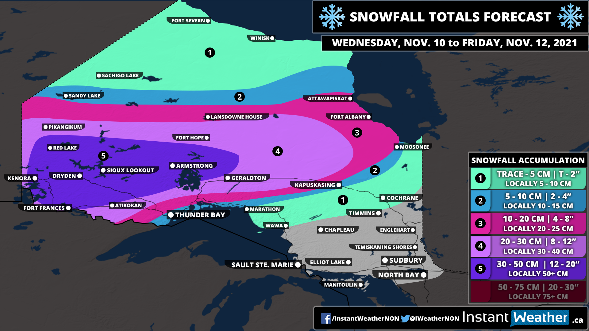
It won’t be quite the joyful Christmas across Northern Ontario when it comes to the weather as a messy winter storm is expected to move through the region beginning Christmas Eve and continuing into Christmas Day. The exact impacts will be very location-dependent as Far Northern Ontario including Sandy Lake through Lansdown House and into the Cochrane region will see heavy snowfall. For Northeastern Ontario, we’re looking at a mix of ice pellets/snow with the risk of prolonged freezing rain closer to Georgian Bay and Lake Superior around Sudbury and North Bay.

Precipitation will begin around the Manitoba border during the morning on Friday with persistent moderate to heavy snowfall expending eastward throughout the afternoon. By Friday evening, we expect the precipitation to start to move into areas east of Lake Superior where it will meet a layer of warmer air above the surface which will result in the development of a line of freezing rain and ice pellets. Current model guidance suggests that this line will stretch from Wawa through Chapleau and down into Sudbury. Keep in mind this is probably the most difficult part of the storm to forecast so it could be a little further north or south. Freezing rain will continue to linger around throughout the evening and even overnight into Christmas morning.

As we head into the later part of the morning on Saturday, we will see the bulk of the precipitation move out of the region. But light snow to the north and some freezing rain in the south will continue into the early afternoon. There is some concern regarding the potential ice accretion from the freezing rain because there won’t be a switch over to rain (except near the shorelines of Georgian Bay and Lake Superior). We also expect some colder air to flood in behind the system later in the day on Saturday which will help hold any of the ice in place on surfaces like trees and power lines. Don’t be surprised to see some power outages on Christmas Day that could continue for several days as the weight of the ice brings down more trees and power lines.

On the cold side of the storm, we’re looking at widespread accumulation ranging from 10-20cm for Far Northern Ontario. The bulk of the snowfall will come late Friday and into early Saturday morning. Lower amounts are expected further south where ice pellets will mix in and reduce the potential accumulation. Areas along the International border including Kenora and Thunder Bay will see mainly snow from this system, but accumulation is expected to be under 5cm due to lack of moisture so it’s not shown on the map.

White Christmas Almost Certain for Central and Eastern Ontario; Green Christmas Possible for GTA and Southwestern Ontario

There was hope that the snowfall over the weekend across much of Southern Ontario might mean that a White Christmas was in the cards this year. However, it appears that Mother Nature will dash any hope of a White Christmas with a push of milder temperatures on Christmas Eve for Southwestern Ontario and the GTA/Niagara Region. There is good news that the cold air should hold on across Central and Eastern Ontario making a White Christmas almost certain this year for those regions.

In the lead-up to Christmas, we’re looking at the chance of some snow both on Wednesday with some lake effect snow around Lake Huron and Georgian Bay and a quick system late Thursday. The system on Thursday will likely deliver around 5cm of snow to parts of Southwestern Ontario and into the Golden Horseshoe. It’s quite possible that many locations even with a very low chance of a White Christmas will wake up to snow on the ground on Christmas Eve.

Don’t let that trick you though! Warmer air will slowly work its way into the province later on Friday (Christmas Eve) pushing the temperature above the freezing mark for areas around Lake Ontario, Erie and Huron along with Deep Southwestern Ontario. Some locations like Windsor may flirt with double-digit highs on Christmas Day! As a result, any snow that was on the ground on Christmas Eve morning will likely be gone by the time you go to bed. There is a chance that some of the higher elevations northwest of the GTA including Orangeville could still hold onto the accumulation long enough to still allow for a White Christmas, but it’s questionable at best. As we mentioned, the cold air will put up a fight across Central and Eastern Ontario so any existing snow accumulation should be maintained going into Christmas morning.

It should be noted that there is some uncertainty in this forecast as a potential system might affect Southern Ontario late on Christmas Eve. At this point, it appears that it could bring a mixed bag of precipitation depending on the track. Rain is looking likely for Southwestern Ontario and along the shoreline of Lake Ontario/Erie. Further north, we may see a freezing rain threat around Lake Simcoe and some accumulating snow through Central and Eastern Ontario.

Again, any shift in the track of this storm either to the north or south may significantly change the White Christmas probability. We might even see a ‘true’ White Christmas through Central and Eastern Ontario with snow coming down as you wake up Christmas morning. This is why a zone around Georgian Bay and extending through Lake Simcoe has only a 75% chance of a White Christmas as they could see some mixing from this system.

More details on this system will follow in the coming days including our final White Christmas forecast to be posted on Christmas Eve (Friday). Check back soon!

Damaging Wind Storm Possible for Northern Ontario on Thursday With Gusts Up to 110 KM/H

We’re tracking the potential for a destructive wind storm throughout much of Northern Ontario. The impacts of this second wind storm will vary depending on location, but it appears the damaging wind gusts will be strongest along the Lake Superior shoreline and into Northeastern Ontario. We’re quite concerned about the wind damage and power outage potential based on the latest data which has further increased the strength of the expected wind gusts.

The latest data shows widespread wind gusts exceeding 90km/h throughout Northeastern Ontario. We could see guests exceed 100km/h in locations including Thunder Bay, Marathon, Wawa and Sault Ste. Marie during the morning hours. The southern portion of Northeastern Ontario will see gusts ranging from 90-105km/h with less of an impact the further northwest you go in the region. Northwestern Ontario isn’t expecting much in terms of wind gusts from this system. However, Northwestern Ontario will see some heavy rainfall with between 20-40mm possible by the end of Thursday in locations such as Atikokan, Sioux Lookout and Armstrong.

We will see the wind begin to pick up during the early morning hours of Thursday for Southwestern Ontario as the deepening low-pressure system that spawned a line of destructive storms across the US Midwest moves into Northern Ontario. The wind gusts will continue to get even stronger later in the morning with the worst conditions expected during the mid to late morning. We should see the wind gusts slowly die down by afternoon however they will remain quite strong through the afternoon ranging from 60-80km/h.

Second Wind Storm in a Week for Southern Ontario on Thursday and Could Be Stronger Than Saturday’s Wind Storm

This has certainly been a weird start to winter across Southern Ontario as instead of snow and wintery weather, we’re tracking the potential for the second destructive wind storm in a week throughout much of Southern Ontario. The impacts of this second wind storm will vary depending on location, but it appears the damaging wind gusts will be way more widespread than Saturday and also affect parts of Central, Eastern and Northern Ontario which didn’t see the full brunt of the wind on Saturday. We’re quite concerned about the wind damage and power outage potential based on the latest data which has further increased the strength of the expected wind gusts.

The latest data shows widespread wind gusts exceeding 90km/h even further inland away from the shorelines. We could see gusts exceed 100km/h through the higher elevations northwest of the GTA, along Lake Huron and into the Hamilton and Niagara region. The Blue Mountains, Collingwood and Orangeville are consistently being highlighted in the data as seeing gusts potential exceed 110km/h. Wind gusts will be weakest through portions of Central and Eastern Ontario, but they’ll still see quite strong wind gusts ranging from 80-95km/h.

We will see the wind begin to pick up during the early morning hours of Thursday for Southwestern Ontario as the deepening low-pressure system that spawned a line of destructive storms across the US Midwest moves into Northern Ontario. The wind gusts will continue to get even stronger later in the morning with the worst conditions expected after sunrise on Thursday. For Eastern Ontario, the stronger gusts will occur during the late morning and early afternoon. We should see the wind gusts slowly die down later in the day however they will remain quite strong going into the evening ranging from 60-80km/h

Aside from the wind, we are looking at another unseasonably warm day with temperatures reaching into the low double digits. It’s possible some areas may break their temperature record. There is also a slight risk of some non-severe thunderstorms later on Thursday as a cold front sweeps across Southern Ontario. This will usher in some colder air bringing temperatures back to near or below the freezing mark overnight Thursday.

In Northern Ontario, the impact of the wind storm will be mostly focused on the Lake Superior shoreline and into Northeastern Ontario. Locations including Thunder Bay, Marathon, Wawa and Sault Ste. Marie may see gusts approach 100km/h during the morning hours. The southern portion of Northeastern Ontario will see gusts ranging from 90-105km/h with less of an impact the further northwest you go in the region. Northwestern Ontario isn’t expecting much in terms of wind gusts from this system. However, Northwestern Ontario will see some heavy rainfall with between 20-40mm possible by the end of Thursday in locations such as Atikokan, Sioux Lookout and Armstrong.

Destructive Wind Storm Possible Across Southern Ontario on Saturday With Gusts Up to 90-120 km/h; Risk of Freezing Rain for Ottawa Valley

A deepening low-pressure system from Colorado will move across Ontario on Saturday bringing with it the threat of potentially damaging to destructive wind gusts to much of Southern Ontario. On the bright side, this system will usher in a brief shot of mild air with temperatures reaching into double digits before a cold front sweeps across the region later in the day putting an end to this. There will also be the threat of freezing rain primarily through the Ottawa Valley and into Northeastern Ontario during the morning hours on Saturday.

We’re expecting the strongest wind gusts to start to pick up around the noon hour with Southwestern Ontario and continue eastward through the afternoon. There is some disagreement amongst the models on the exact strength of these gusts with conservative estimates of around 80-90km/h inland and near 95-100km/h along the shorelines. While more aggressive models point towards what could be the strongest wind storm we’ve seen in years for this region with widespread gusts from 90-105km/h and up to 120km/h for the northeastern shorelines of Lake Ontario and Erie. Regardless of what happens, the winds will be still quite strong and may result in many power outages across Southern Ontario. Be prepared for some wind damage and bring in anything that could be blown away. Secure your holiday decorations!

We have a particular concern for those regions right along the northeastern shoreline on Lake Ontario and Erie due to the very strong southwesterly winds which could gust up to 120km/h. Aside from the potential wind damage, this will likely cause very high waves on the lakes and result in some shoreline flooding. Locations such as Port Dover, Port Colborne and Prince Edward County should be prepared for flooding in areas that have a history of wind-related flooding.

The strong wind gusts will continue into the evening especially for Eastern Ontario. However, we should start to see them die down somewhat later in the evening and as we head into the overnight hours. In addition to the strong wind, we’re also expecting some heavy rainfall with the latest model data pointing to widespread totals between 10-20mm. There is currently a rainfall warning in effect for a wide swath of Southern Ontario, but we’re just not seeing the widespread potential for more than 20mm at this time. In fact, a few models point towards this system underperforming in terms of rainfall with less than 10mm in some areas. Now, there is the risk for some non-severe thunderstorms through Southwestern Ontario and into the Golden Horseshoe which could lead to localized higher rainfall total.

While most of Southern Ontario will see a rapid rise in temperatures overnight and early Saturday morning as a result of some milder air, the same can’t be said for Northeastern Ontario and parts of the Ottawa Valley. It appears that the cold air will be a little more stubborn in this area during the morning which will allow for the risk of freezing rain. It could linger for several hours before the warmer air finally wins over and is able to cause the temperature to rise above the freezing mark.

Ice accretion ranging from 2-6mm can’t be ruled out for locations such as Ottawa, Renfrew, Petawawa, North Bay and Sudbury which could lead to icy road conditions and some power outages. Depending on how fast an existing ice accretion is able to melt, this may add an additional variable to the power outages risk later in the afternoon as the strong wind gusts move in Eastern Ontario. The freezing rain risk will come to an end by the early afternoon hours as it switches over to regular rain.

Snowstorm Takes Aim at Parts of Northern Ontario With Up to 15–25cm of Snow Between Sunday and Monday

A snowstorm is set to bring heavy snowfall to Northern Ontario starting Sunday morning and lasting into Monday. While Southern Ontario will be dealing with a messy mix of snow, freezing rain, sleet and regular rain, Northern Ontario will be on the colder side of this system and see all snow from this storm. Expect hazardous driving conditions throughout Sunday so if possible you should consider waiting until conditions improve on Monday until doing any driving. Blowing snow may also be an issue with wind gusts between 40-70km/h so reduced visibility is possible.

Snow will start late Sunday morning and pick up in intensity throughout the day and into early Monday. The heaviest accumulation will include all of Northeastern Ontario and into the Thunder Bay region where between 15-25cm is possible. Lower amounts are expected as you go further to the northwest where there will be less moisture. The snow will taper off by early Monday afternoon as the system moves out over Quebec.

Winter Storm Takes Aim at Parts of Southern & Northern Ontario With Up to 15–25cm of Snow & Freezing Rain Between Sunday and Monday

A tricky system is set to bring a wide range of wintery precipitation to Southern Ontario starting Sunday afternoon and lasting into Monday. The exact impacts from this winter storm will vary greatly depending on your location so while some will need their snow shovels, others will just need an umbrella. We’re looking at accumulating snowfall with as much as 15-25cm possible in parts of Central/Eastern Ontario and stretching up into much of Northern Ontario. Further south, the story will be a few hours of ice pellets and freezing rain during the late part of Sunday then switching over to regular rain by Monday morning. In some areas, this freezing rain could lead to a thin layer of ice accretion and lead to icy road conditions, but at this point, we don’t expect anything significantly impactful. Those in Southwestern Ontario and around the Golden Horseshoe will come out of the ‘storm’ with barely anything but some heavy rainfall.

TIMELINE FOR SOUTHWESTERN ONTARIO & GTHA

TIMELINE FOR EASTERN & CENTRAL ONTARIO

The storm will begin to affect our region sometime during the afternoon on Sunday as an initial band of precipitation slides across Southern Ontario. It looks like most areas will still be near the freezing mark at this time so it will likely come down in the form of light snow. This is only the start of the system as the main wave of precipitation enters the province from Michigan a few hours later. It will be mainly in the form of rain for the Windsor and Sarnia area, but the system will encounter some colder air further north through Grey-Bruce and east of Lake Huron so here we will see a messy mix of precipitation ranging from snow to freezing rain.

The heavier precipitation will continue to the northeast with heavy snow encompassing most areas around Georgian Bay during the dinner hour and into the evening. For areas to the south, we will begin to see a slow transition over to rain although this will take a few hours. And there might be some sleet and freezing rain that mixes in during this transition period late Sunday into early Monday morning. Higher elevations that include the Dundalk Highlands (Orangeville, Shelburne etc.) into the Kitchener-Waterloo area could see some more sustained freezing rain during the evening hours. Those south of Lake Simcoe should have switched over to rain around midnight while the mixing line will slowly continue northward.

For Eastern Ontario, the precipitation won’t reach that area until the evening with snow to start and the risk of a few hours of freezing rain during the overnight particularly through the Ottawa Valley and Bancroft area. The Kingston and Brockville region will escape the worse with a faster transition over to rain just after midnight which will limit any impact from snow or freezing rain. All areas through Eastern Ontario will have transitioned over to rain by mid-morning, but a slick morning commute is still expected due to the previous snow and freezing rain combined with more moisture.

Conditions for all areas of Southern Ontario will begin to improve later in the morning on Monday as warmer air causes a brief rise in temperature for at least the early part of Monday. The cold air will return later in the day which may pose a flash freeze risk depending on how fast the temperature drop occurs.

Refer to the timeline graphics above for more specific details on timing and impact for your region.

In terms of snowfall accumulation, the heaviest snowfall totals will be found in the more northern part of our region. This zone where there is the potential for 15-25cm of snowfall accumulation extends north of a line from Parry Sound through Huntsville and into the Renfrew area. Just to the south, there is some tremendous uncertainty regarding exactly how much snowfall accumulation be expected. This includes Southern Muskoka and into the Ottawa Valley where anywhere from 5-15cm of snowfall accumulation is possible. This uncertainty is due to some sleet and freezing rain mixing in which would reduce snowfall totals. However, it’s unclear how fast the transition to sleet or freezing rain will happen. Lower amounts are expected to further south you go with most of the accumulation being contained to regions north of Lake Simcoe.

As we’ve mentioned, the areas with the highest risk of freezing rain will include the Dundalk Highlands and parts of the Ottawa Valley and Algonquin Park. The freezing rain will be highly elevation-dependent so it should be mostly contained to these areas where it could be noticeable on untreated roads and may even accrete on surfaces to an extent. Outside of this, very limited accretion is expected as the transition will be quite quick, but could still lead to some isolated icy road conditions until the switch-over happens.

Those in Southwestern Ontario and around the Golden Horseshoe will see primarily rain with totals ranging from 10-25mm. A few localized areas may pick up over 25mm especially as it’s not out of the question that we see some non-severe thunderstorm activity in Deep Southwestern Ontario which would boost totals. Wind gusts appear less strong than earlier data indicated so we’re going with widespread gusts between 60-80km/h with the potential for gusts near 90-100km/h for those in the Niagara Region to the northeast of Lake Erie. Blowing snow may also be an issue with these strong wind gusts.

The effects of this system won’t be just felt in Southern Ontario, but Northern Ontario will be on the cold side of this storm so they’re looking at heavy snowfall. Snow will start late Sunday morning and continue throughout the day and into early Monday. Accumulation will range from 15-25cm including most of Northeastern Ontario and into the Thunder Bay region. Lower amounts are expected as you go further to the northwest where there will be less moisture. The snow will taper off by early Monday afternoon as the system moves out over Quebec.

First Messy Winter Storm of the Season Takes Aim at Southern Ontario Between Sunday & Monday; Damaging Wind Storm Overnight Sunday Possible

Forecast Discussion

We’re only a few days into December and already talking about the first winter storm of the season that could possibly affect Southern Ontario starting Sunday and lasting into Monday. Now, this system will be very location-dependent with some areas seeing mostly just rain, others seeing a mixed bag of wintery precipitation and heavy snow to the north. There will also be some quite strong winds associated with this system with gusts approaching 90-100km/h late Sunday evening and into Monday morning. The strongest wind gusts appear to be focused on Southwestern Ontario and through the GTA along with the shorelines of Lake Huron, Ontario and Erie. Wind damage along with power outages can’t be ruled out especially when combined with the freezing rain in some areas.

We will see the first bands of precipitation enter the region in the form of some wet snow during the afternoon on Sunday which will continue for areas north of Georgian Bay as more moisture is pumped into the region. Further south, another wave of precipitation will work its way across Southern Ontario from Michigan by the evening. At this point, temperatures through Southwestern Ontario and along the shoreline of Lake Huron, Erie and Ontario will be several degrees above the freezing mark so it should come down as rain with maybe some brief freezing rain in the higher elevations. This includes the GTA which should be mostly unaffected by this winter storm and will feel more like a damp and cold fall storm with rain and wind.

The concern with this system lies in the mixing zone further north from Central and Eastern Ontario with will be still a few degrees under the freezing mark going into the evening and overnight. There is some uncertainty around the extent of this cold air and how long it can hold up against the flow of warm air from the south. This will dictate the type of precipitation that comes down including freezing rain, ice pellets/sleet and snow. We are looking at a few hours of freezing rain extending from Owen Sound through the Dundalk Highlands and into the Ottawa Valley during the late evening and early overnight. This will transition over to regular rain overnight as temperatures rise above the freezing mark, but roads could still be quite icy.

Up into the southern part of the Bruce Penisula through Southern Muskoka and into Bancroft/Renfrew it will start as some ice pellets in the evening. Then a few hours of freezing rain overnight before transitioning over to regular rain by early morning. The more impactful wintery precipitation will be found north of a line stretching from Tobermory through Huntsville and into Pembroke where snowfall accumulation from 5-10cm during the evening and overnight is possible. This will switch over to ice pellets and maybe some brief freezing rain early Monday morning before some rain mixes in by sunrise. Northeastern Ontario including Sudbury and North Bay will come out on top when it comes to snowfall as they’re expected to remain on the cold side of this storm and pick up between 10-25cm by Monday morning.

All areas should rise above the freezing mark during the day on Monday which should help melt away any accumulation from the storm. However, the below-freezing temperatures return overnight into Tuesday so this may refreeze any precipitation still present on roads and make for icy conditions for Tuesday morning. And the lake effect snow machine may kick back into gear for Tuesday bringing the threat of more accumulating snow around Georgian Bay and Lake Huron.

More details on timing and accumulation will be released by Saturday evening in our full forecast. Keep in mind this forecast is preliminary and may be subjected to changes depending on the latest data. There is one model (the Canadian model) that shows a more southern scenario which would push the accumulating snow and freezing rain further south. However, we’re going with the consensus at the moment which is the more northern track.

Arctic Air To Kick Off an Impactful Snow Squalls Event Between Monday and Tuesday With 15–30cm of Snow Accumulation; Locally Up to 40cm for Grey, Bruce and Simcoe Counties

The first push of frigid Arctic air will bring temperatures well below the freezing mark through Southern Ontario to start off the week. This cold air will also turn the lake effect snow machine onto full blast through parts of the snowbelt starting Monday morning and lasting through to Tuesday. Intense snow squalls with the worst conditions found during the day on Monday and overnight into early Tuesday will set up off Georgian Bay and Lake Huron in a northwesterly flow and stretch quite far inland at times. There will also be some strong wind gusts between 40-60km/h resulting in localized blowing snow and near-zero visibility out on the roads which will make travel near impossible through the affected regions.

It’s still a little uncertain on the exact placement of the snow squalls which will determine who sees the most snowfall accumulation from this event. Model data earlier in the day showed one main band off Lake Huron somewhere near Saugeen Shores and stretching as far inland as the Hwy 400 corridor south of Barrie. However, the most latest data shows a clearly northern shift in the location of the bands which would allow for some further enhancement from Georgian Bay. This would put the squall from Lake Huron over Wiarton/Owen Sound and it’ll move across Georgian Bay picking up more moisture before pushing into Simcoe County and Northern Grey County. Some additional activity. For our forecast, we’re going with the latest data, but keep in mind that we may have to make adjustments to our map if it shifts back. We will update it by the end of Sunday evening at the latest based on the evening model data.

Snow squalls and lake effect snow will develop off Lake Huron and Georgian Bay early Monday morning with a primarily westerly flow which will affect the Bruce Peninsula and into the Muskoka/Parry Sound region. This activity will be fairly weak so significant accumulation isn’t expected with maybe 5-10cm max before it shifts southward later in the morning. The lake effect snow will further intensify into a strong squall towards the late morning hours as it reaches the Northern Simcoe County region.

Now, the key thing will be if it stabilizes and stops shifting to the south locking into somewhere through Southern Bruce Peninsula, Meaford, Owen Sound, Simcoe County and areas directly east of Lake Simcoe. If it does this then we could easily see snowfall totals ranging from 20-40cm by the evening in localized pockets with general totals between 10-25cm. Heavy snowfall could be found quite far to the east as the squall will have a lot of fetch and strong winds to push it far inland. Locations such as Lindsay, Kawartha Lakes and Peterborough who traditionally don’t see a lot of lake effect snow may get up to 10-20cm along with poor driving conditions.

After the dinner hour, we expect the squall to move southward again with the enhancement off Georgian Bay being shut off and it becoming mainly fueled by Lake Huron. The fetch won’t be as intense compared to earlier in the day so the lake effect activity will be more contained to the Lake Huron shoreline. The most significant impact from this squall late Monday and into the overnight hours will be felt through the Saugeen Shores, Kincardine, Hanover, Chatsworth and Minto region where locally up to 20-40cm is possible by Tuesday morning. Some less organized lake effect snow is also possible off the southeastern shoreline of Georgian Bay early Tuesday morning with a focus on the Collingwood/Angus area potentially stretching across Hwy 400, but the Lake Huron squall will be the main event. All lake effect snow and squalls should taper off by the afternoon on Tuesday.

Please note that the accumulation map that we provided in this forecast is meant to show the maximum accumulation possible from the snow squalls. Due to the localized nature of lake effect snow, one location can get 50cm while just down the road could see less than 5cm so it’s quite hard to factor these hyper-local dynamics into the forecast. Lake effect snow is probably one of the most difficult things to forecast as just a slight change in the wind direction can shift the heaviest snow in a different direction. Even if we’re forecasting up to 40cm doesn’t mean you’re guaranteed to see it and you may see nothing at all. Just the potential is there should the environment line up. Similar to tornadoes, they don’t affect everyone within the risk zone. Sometimes the lake effect snow just doesn’t materialize to the extent that we’re expecting and sometimes they’re much stronger resulting in overachieving snowfall totals. We are continuously going over the latest update and will revise our map later Sunday evening if needed.

Snow Squalls To Bring Up to 20cm of Snow to Areas East of Lake Huron and Georgian Bay Between Thursday Evening and Friday Morning

Colder air returns to Southern Ontario after a brief shot of mild weather which has resulted in the development of lake effect snow late Thursday and is expected to further intensify into squalls by the evening.

The focus of these squalls will be on a zone east of Georgian Bay with the heaviest accumulation in locations such as Parry Sound, Port Carling, Bracebridge, Gravenhurst and Miden. There will also be some less organized squalls off Lake Huron with higher amounts further inland over the Hanover, Minto, Wingham and Listowel area. Total accumulation could approach the 20cm mark locally with general amounts around 10-15cm.

Those closer to the shoreline will see lower amounts due to temperatures staying above the freezing mark which will mean the snow will struggle to accumulate. The lake effect activity will drift southward during the morning on Friday bringing the heavy snow to locations such as Collingwood, Wasaga, Angus, Goderich and Stratford. However, the squalls won’t last long until fizzling out by the afternoon hours so accumulation should be limited to around 5cm with maybe some localized pockets picking up to 10cm.

Snow squalls can cause quite dangerous driving conditions through the affected regions with near-zero visibility and rapid snowfall accumulation. It is highly recommended that you avoid travel during the evening and overnight hours if you can. Otherwise please leave lots of time to get to your destination safely! The morning commute will likely be impacted, but conditions should be a little better than compared to the overnight hours. School bus cancellations are possible Friday morning which we will cover in our snow day forecast to be issued Thursday evening.

Midweek Snowstorm To Bring Up to 30cm of Snow to Parts of Northwestern Ontario Between Tuesday and Wednesday

The low-pressure system currently bringing record-breaking flooding to parts of British Columbia will race across the Prairies and start to affect Northwestern Ontario starting Tuesday morning with the initial bands of precipitation. Instead of rain, we are mainly looking at snowfall which could come down quite heavy at times. The system will be a lot weaker than when it made landfall in BC so this won’t be any more than a fairly typical snowstorm for the region.

We will see the worst conditions from this storm through Sandy Lake and Sachigo Lake during the later part of Tuesday and into Wednesday morning. Heavy snow combined with strong wind gusts up to 50-70km/h could create very poor travel conditions. Snow will continue during the day on Wednesday, but it won’t be as intense with the heavier precipitation being found along the Quebec border. There could be the risk of some freezing rain just north of Sudbury during the morning on Wednesday although confidence in that is low. The system will finally exist in the region by the end of Wednesday, but a few flurries may linger into Thursday.

We’re looking at around 20-30cm of snowfall accumulation through the hardest hit zone including Sandy Lake, Sachigo Lake, Fort Hope and Lansdowne House. A few localized areas could pick up more than 30cm. Other parts of Northwestern Ontario can expect around 12-20cm with between 6-12cm for the rest of Northern Ontario away from the shoreline of Lake Superior and Georgian Bay. We will likely see some rain along the shorelines which will reduce potential accumulation.

Snow Squalls Brings Snowy Blast to Parts of the Snowbelt Around Lake Huron and Georgian Bay on Monday With Locally Up to 15–25cm Possible

The start of the week through parts of the traditional snowbelt southeast of Lake Huron and Georgian Bay will get off on a snowy note as some organized lake effect snow and localized squalls are expected to develop early Monday. Current indications suggest that a fairly strong squall could develop off Lake Huron during the mid to late morning hours on Monday stretching from Goderich and further inland towards Stratford.

In addition to this, we will see some lake effect activity off Georgian Bay during the late morning affecting the Collingwood and Wasaga area along with the Hwy 400 corridor between Barrie and Bradford. This will continue throughout the day and may even linger into the overnight hours into predawn Tuesday. However, it should dissipate by mid-Tuesday morning so it shouldn’t have a significant impact on the morning commute.

As is typical with lake effect snow events, predicting the exact accumulation is very tricky as it depends on how strong the bands are and where exactly they lock-in. We do believe there is the potential that someone just to the southeast of Goderich including Clinton, Wingham, Listowel and Stratford could pick locally up to 20-25cm, but general snowfall amounts around 10-20cm are more likely. Surrounding regions including the Lake Huron shoreline where temperatures will be slightly warmer can expect between 5-10cm with locally up to 15cm. The Collingwood and Angus corridor could see around 10-15cm in the hardest-hit locations. The City of Barrie should escape the worst although the south end of the city could pick up near 10cm with around 5cm in the north end.

Travel conditions throughout the day on Monday will likely be very poor within the affected regions so be sure to take your time and maybe avoid travelling until conditions improve. Snow squalls can cause rapid reductions in visibility and make it hard to adjust to conditions.

Fast-Moving System To Bring Southern Ontario’s First Widespread Snowfall of the Season Between Sunday and Monday

We’re now getting deep into November and it was only a matter of time before Mother Nature started to throw some wintery weather at Southern Ontario. And just that is in store for our region starting Sunday morning as an approaching weak system brings a mix of winter weather including rain and wet snow. For areas away from the lakeshore, we could be looking at several slushy centimetres of snow over the next 36 hours.

Now, this generally wouldn’t be considered a significant snowfall, but it will be quite wet and may make for some slippery driving conditions so you should drive according to the conditions. Less snow is expected through Extreme Southwestern Ontario, Niagara, GTA and in Eastern Ontario northeast of Lake Ontario. This is due to slightly warmer temperatures which will allow for more melting and some rain to mix in which would reduce overall accumulation.

This system is lacking in moisture which explains the lower snow totals across the region, however, a few pockets including to the northeast of Lake Erie east of London and through Central Ontario from Parry Sound into Algonquin Park may experience some lake enhancement. This could boost up the expected snow totals to near 10cm, but it’s not guaranteed especially in that Lake Erie zone which could be reduced by some rain mixing in.

The system will move out of the province by the mid-morning hours on Monday. We may see some lake effect snow develop off Georgian Bay and Lake Huron in the wake of the system later Monday although the exact intensity of this is unclear so it’s not included in the forecast.

Wintery Blast To Bring Northern Ontario’s First Significant Snowfall Between Wednesday and Friday With Up to 50cm of Accumulation Possible

A potential major snowstorm is on the horizon for parts of Northwestern Ontario over the next day as a strengthening low-pressure system stalls out and pumps moisture from the Gulf of Mexico into the region. This combined with a push of cold Arctic air will allow from rapidly accumulating snowfall starting late Wednesday, continuing through Thursday and lingering into Friday. The heavy snow will also be accompanied by some very strong wind gusts which will result in blowing snow and near whiteout conditions out on the roads.

Conditions will begin to deteriorate starting Wednesday evening as the first bands of snowfall enter the region from Manitoba and Minnesota and slowly spread to the north and east throughout the overnight hours. The worst conditions will be found during the day on Thursday when the snow will be at its heaviest in addition to the wind starting to pick up. Travel will likely be near impossible on Thursday through the Kenora, Dryden, Sioux Lookout and Armstrong area and we may even see some highways closures. This will continue overnight and into Friday will very rapid snowfall accumulation still occurring for much of the day on Friday too. We will finally see the system move out of the region by late Friday, but some snow may still continue especially near the Quebec border and around James Bay.

For accumulation, we’re looking at a maximum of around 30-50cm with locally in excess of 50cm. This zone includes the Kenora, Dryden, Sioux Lookout, Fort Frances and Armstrong areas. Other locations such as Atikokan, Geraldton and Fort Hope will see slightly lower amounts topping out at between 20-30cm. As for Thunder Bay, they’re right on the mixing line and may see some rain mix into the wet flurries which will help stop much accumulation from occurring. Right now we’re saying 5-10cm although this may change depending on the track of the system.

An Eerily Mild Halloween Across Southern Ontario With Wicked Lake Effect Showers Around Lake Huron and Georgian Bay

Will it be trick or treat across Southern Ontario for Halloween? Well it appears that Mother Nature has been brewing a mixed bag in our cauldron of weather. While we aren’t expecting any spine-chilling temperatures like in previous years or spooky snow, we could be looking at some gruesome lake effect showers around Lake Huron and Georgian Bay during the evening hours. This could be quite the nightmare as it puts a damper on the little witches and warlocks going door to door looking for treats (or tricks). You may want to grab a ghoulish umbrella before heading out so everyone can remain bone dry. We aren’t expecting much in terms of rainfall totals from the lake effect showers, but it will be sure to make for a damp night in some areas. The rest of Southern Ontario is looking at quite the treat of a night with temperatures in the upper single digits to low double digits throughout Southwestern and Eastern Ontario along with the GTA and Niagara region. We hope you have a very frightening and safe night!

Colorado Low Set To Bring Up to 40-75mm of Rainfall and Strong Wind Gusts to Southern Ontario Early This Week (Sunday - Tuesday)

UPDATED MAP - Oct. 25 (12:30 AM)

UPDATE (Mon - Oct. 25): We have made a few adjustments to our map, but it mainly stays the same overall. The main changes are to reduce the rainfall totals for Eastern Ontario while increasing them for areas further to the north and west. This is due to a change in the track of the system which appears to put the bulk of the precipitation further west rather than locking in on Eastern Ontario.

We are still expecting total rainfall accumulation between 40-75mm for the Windsor, Sarnia, London and Hamilton/Niagara regions by the end of Tuesday. The rest of the GTA and Southwestern Ontario can expect between 25-50mm. Eastern and Central Ontario will range from between 15-30mm with higher amounts closer to Lake Ontario.

In addition to the rainfall, there will also be some strong wind gusts that are expected to develop early in the afternoon around Lake Huron and spread eastward throughout the rest of the day. At this point, they should remain below severe levels although it’s right on the line. We may see a few localized gusts come close to 90km/h particularly along the shorelines. Waiting for the data in the morning and if it appears we could see severe gusts we will issue a forecast map at that time.

OLD FORECAST

It has been a fairly quiet fall across Southern Ontario with a few heavy rainfall events and of course the unseasonably warm weather. But we’re slowly seeing the weather that we would normally see for this time of year after parts of Southern Ontario saw the first flurries of the season this weekend. Now we’re watching a strong Colorado low that’s expected to affect Southern Ontario starting late Sunday and continuing for much of the early part of the week. This low-pressure system will bring the threat of heavy rainfall along with some strong wind gusts. Some areas along the Lake Erie shoreline and into parts of Eastern Ontario could see rainfall totals between 40-75mm by the end of Tuesday.

We’ll begin to see the initial bands of precipitation reach Extreme Southwestern Ontario by the dinner hour on Sunday and it will slowly expand to the north and east throughout the overnight hours and into Monday. This will make for a wet Monday during the morning and afternoon as heavy rain encompasses most of the region from Windsor through to Ottawa. In addition to the rain, we will also see some strong wind gusts between 60-80km/h and maybe even near severe levels at 90km/h during the afternoon and evening on Monday.

As we head into the overnight hours and into Tuesday we should see the rain become less widespread except for Eastern Ontario which will continue to see heavy rainfall lasting through the early part of Tuesday. Some colder air will also flow into Central Ontario early Tuesday morning with near-freezing temperatures which may set the stage for the existing rain showers to transition over to some wet flurries particularly east of Georgian Bay. No accumulation is expected. Although confidence is low at this point so that’s not guaranteed. All of the precipitation should come to an end by late Tuesday as the system finally exits the province.

Total rainfall accumulation will be the highest through the Windsor, Hamilton and Kingston corridor where between 40-75mm of rainfall is possible. The rest of the GTA, Extreme Southwestern Ontario and into Eastern Ontario can expect around 25-50mm of rainfall. Those further north and west will see lower rainfall amounts with totals ranging from 15-30mm for the rest of Southwestern and Central Ontario. Less than 20mm is on tap for regions east of Georgian Bay and into Northeastern Ontario. Note that this is only a preliminary look at the expected rainfall totals and it may change as we get closer to the event - a final rainfall map will be issued by Sunday evening including a wind gust forecast if needed.

Southern Ontario: Heavy Rainfall To Start Off the Weekend With Up to 20-40mm of Rain Possible by Saturday

Forecast Discussion

A low-pressure system is expected to move into Southern Ontario bringing with it some scattered non-severe thunderstorms and heavy rainfall to Southern Ontario late Friday. This will continue into the overnight hours before another round with more organized bands of rainfall moves across the more eastern section of the region during the day on Saturday. We expect the highest rainfall totals along the Lake Erie shoreline and into Eastern Ontario where between 20-40mm (locally up to 50mm) is possible. Further west, we will see lower totals through Southwestern and Central Ontario with rainfall totals ranging from 10-20mm (locally up to 25mm). The rainfall will come to an end late Saturday although we may see some more rain on Sunday.

Keep in mind that this forecast is just a rough idea of the expected rainfall totals. Due to the rainfall being connected to thunderstorm activity, some areas may overperform this forecast should the thunderstorm activity shift around. There may also be some underperformance with the forecast due to the localized nature of the storms.