Early Taste of Spring Across Southern Ontario on Sunday With Double-Digit Temperatures, Damaging Wind Storm and Thunderstorm Risk
/We are in for quite the wild ride when it comes to the weather across Southern Ontario over the next few days. The active weather will begin on Sunday as a system ushers unseasonably warm air into the region which will result in many areas seeing temperatures reach into the double digits for early Sunday. However, this blast of warm air will be accompanied by rain and even non-severe thunderstorms mainly during the morning on Sunday. We aren’t expecting a significant amount of rain so flooding shouldn’t be a major concern, but areas that experience thunderstorm activity could see locally higher rainfall totals. Looking at general rainfall totals ranging from 5-10mm with locally 10-20mm in those locations that see the thunderstorms.
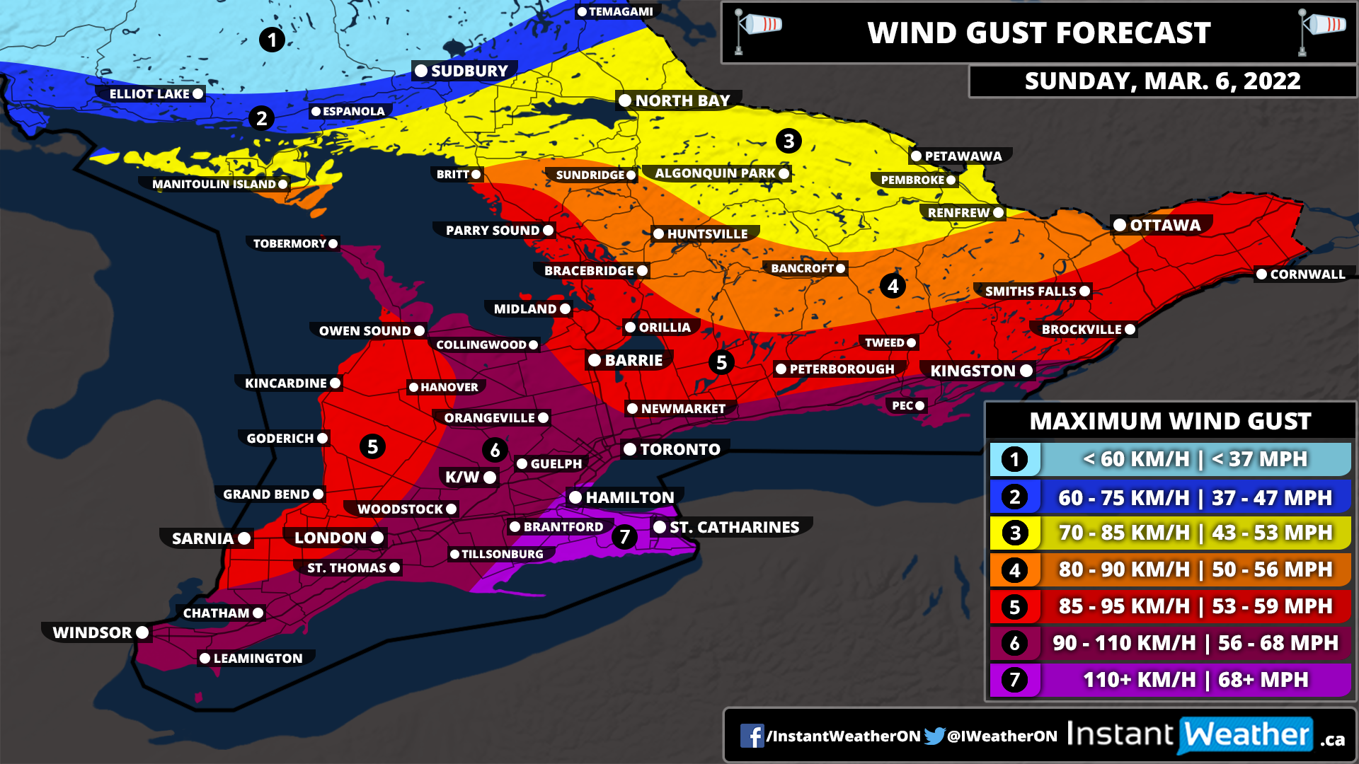
The biggest story from this system will certainly be what is shaping up to be a potentially significant wind storm across Southern Ontario. These strong wind gusts will start to pick up in Southwestern Ontario just after midnight and continue to persist throughout the morning on Sunday. Later in the morning, we will see the damaging wind gusts expand further to the east including the Golden Horseshoe and into Eastern Ontario. We expect the worst of this wind storm will be felt during the late morning and early afternoon with the winds weakening later in the day as we head into the evening hours.
Current indications suggest that the strongest wind gusts will be found through the Niagara and Hamilton region. Especially around the Grimsby and Niagara-on-the-Lake area that borders the Lake Ontario shoreline. We believe that wind gusts here could exceed 110km/h at the height of the event and potentially even approach the 115-125km/h range. This could result in very severe wind damage throughout the region including the possibility of power outages. Be sure to secure anything on your property that could be blown away!
Those around the Lake Ontario and Erie shoreline along with through the higher elevations of the Dundalk Highlands can expect wind gusts of between 90-110km/h. This includes Deep Southwestern Ontario (Windsor, Chatham and London) along with the K/W, GTA and Kingston regions. The rest of Southwestern Ontario into parts of Central/Eastern Ontario are looking at wind gusts ranging from 85-95km/h. Less of an impact when it comes to the strong wind gusts are expected further to the north and west including Algonquin Park, North Bay and Sudbury which will still see strong wind gusts but shouldn’t reach severe levels.
As mentioned, this system will temporarily boost the temperatures across Southern Ontario with the warmest air from Windsor through London and around the GTA. The daytime temperature here will range from 14 to 18°C and we can’t even rule out one or two locations even flirting with the 20s, but it’s questionable.
Don’t expect these warm temperatures to last all day as the daytime high will likely be hit sometime during the late morning or early afternoon and quickly drop back into the single digits later in the day. The rest of Southern Ontario except for northern parts of Central Ontario and Northeastern Ontario will see a daytime high in the low to mid-teens.
This will be short-lived as below-freezing temperatures will return to much of Southern Ontario by Sunday night! The drop in temperature to below freezing appears to be fairly gradual so a flash freeze shouldn’t be a threat, but that could change. However, we are watching what could be an impactful winter storm across Southern Ontario on Monday and Tuesday. This also includes the risk of prolonged freezing rain for a large portion of the region. More details on that are to come on Sunday once the exact impact is more certain.
There will also be a cold side to this system, but for the most part, the wintery precipitation will stay to the north of Southern Ontario. Although there is a brief risk of freezing rain during the very early morning hours on Sunday for Northern Central Ontario and into the Ottawa region. This will quickly come to an end as temperatures rise well above the freezing mark later in the morning. More prolonged freezing rain is expected through Northeastern Ontario including Elliot Lake, Sudbury and North Bay. See our Northern Ontario forecast for more details on the impacts this system will have there.


