
UPDATED: Significant Blizzard to Hit Southern Ontario on Friday and Saturday; Up to 25-40cm of Snow Possible
/UPDATED fORECAST

NOTE: You can click on the map to open a zoomable image which will be easier to read.
Forecaster: Brennen Perry
Published: Friday, March 3, 2023
Based on the latest data, we have made some slight adjustments to our snowfall forecast for Friday into Saturday. For most regions, this means that the expected snowfall totals have increased compared to our previous forecast. With intense snowfall rates approaching 5-10cm/hour at the height of this storm by Friday night, it’s almost guaranteed to have a crippling impact on travel across much of Southern Ontario. Strong wind gusts developing tonight and lasting into Saturday morning could reach up to 60-90km/h leading to blizzard conditions and near-zero visibility.
It can’t be repeated enough: DO NOT TRAVEL TONIGHT OTHER THAN FOR ESSENTIAL PURPOSES!! Please let road crews and emergency officials do their job tonight and stay off the roads. Highway closures even in urban areas including the GTA can’t be ruled out similar to what we saw during the blizzard in January 2022.
From Environment Canada’s latest updated Winter Storm Warning for the GTA;
“Significant winter storm with dangerous travel conditions expected tonight. Non-essential travel strongly discouraged.”

NOTE: You can click on the map to open a zoomable image which will be easier to read.
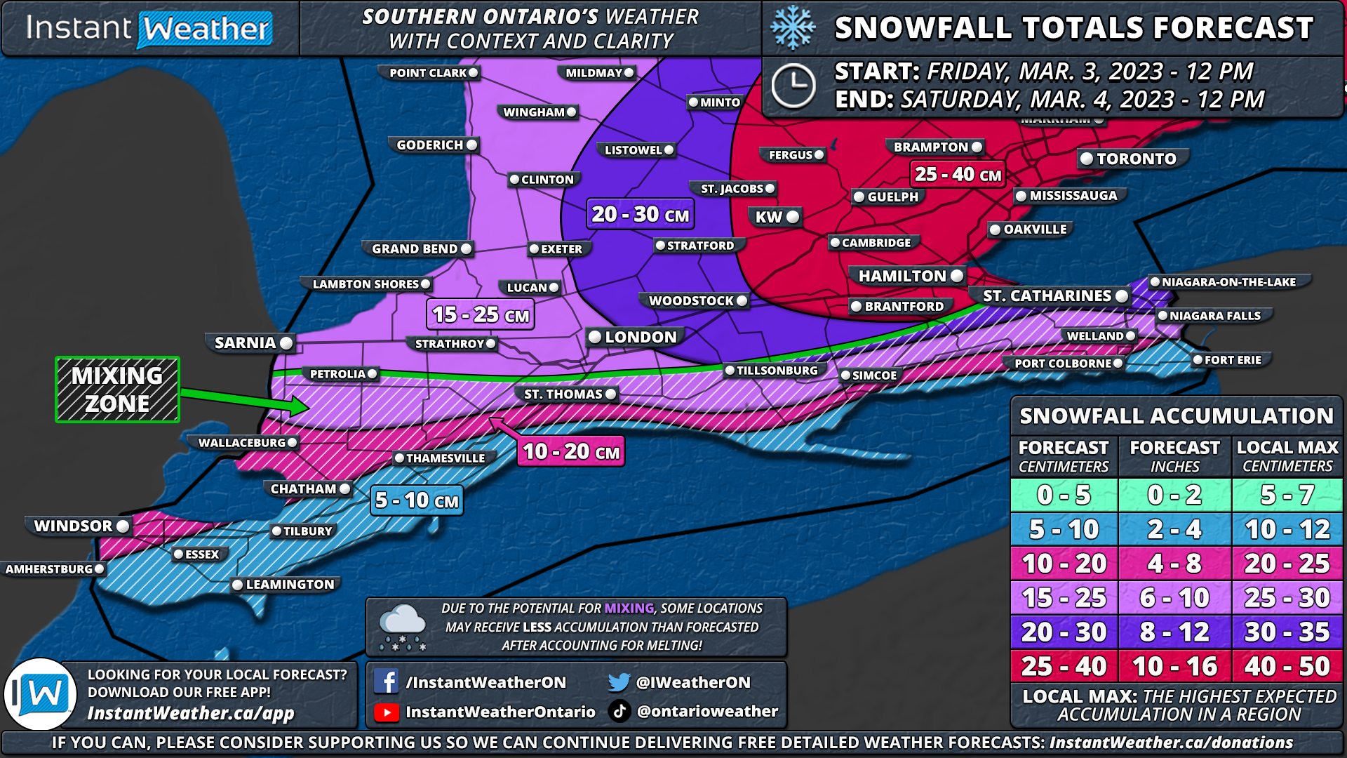
High-resolution models consistently show a fairly expansive zone encompassing much of the Golden Horseshoe from Hamilton through the GTA and into Kingston getting the worst of this storm. Snow will quickly pile up starting in the early evening with heavier bands of snow affecting the region by midnight. While 25-40cm may seem like an average to slightly above average snowstorm for most, the important aspect of this event is that it will come within such a short timeframe. If we get the 5-10cm hourly snowfall rates some models are suggesting, it would only take a few hours to get the forecasted amount. This isn’t a multi-day or even 24-hour snowfall event which would give road crews time to keep the main roads cleared. This will be impossible to keep up with the rapid snowfall accumulation.
There are strong indications of this storm ‘overachieving’ based on the latest data hence why we’ve increased the maximum expected snowfall accumulation from 20-35cm to 25-40cm. This may even still be too low so some areas could approach our ‘local max’ as indicated on the legend. Especially considering that this system will be further enhanced by Lake Ontario which can be hard to nail down in advance. Thundersnow is also quite possible so don’t be surprised to see some lightning with the snow tonight!
NOTE: You can click on the map to open a zoomable image which will be easier to read.
The forecast gets tricky further south along the Lake Erie shoreline. Models are having a hard time handling the potential for mixed precipitation in Deep Southwestern Ontario. Depending on how much mixing with ice pellets and rain occurs, it could lead to substantially less snowfall accumulation. But on the other hand, if it stays all snow then we could be looking at 20+cm for locations such as Windsor, Chatham and Port Colborne. We’ve lowered the expected accumulation to 5-10cm directly along the Lake Erie shoreline with closer to 10-15cm further north in Windsor and Chatham.
In Eastern and Central Ontario, we’ve increased the snowfall totals there as well because the system is expected to have more moisture to work with on its northern flank. This will allow for widespread snowfall accumulation of 10-25cm across Muskoka, Bancroft and into the Ottawa Valley. Less snow is still expected the further north you go, with less than 5cm of snow in Northeastern Ontario.
PREVIOUS fORECAST

NOTE: You can click on the map to open a zoomable image which will be easier to read.
Forecaster: Brennen Perry
Published: Thursday, March 2, 2023
The concern is growing for what could be the most impactful system we’ve seen in Southern Ontario since last January when a potent blizzard left many stuck in widespread snowfall totals of 30-50cm. This upcoming storm has some similarities in terms of intensity and impacted areas compared to the January 2022 storm, but will likely fail to reach the 50+cm snowfall totals we saw last year. As we end off the first (partial) week of ‘meteorological spring’, it certainly won’t feel like that across Southern Ontario with an approaching system from the southwest expected to move into our region starting Friday afternoon.
Current indications suggest that this system will deliver a significant dumping of snow across a wide swath of Southern Ontario including Southwestern Ontario, the Golden Horseshoe and into Eastern Ontario. Combined with strong wind gusts near 60-80km/h and intense snowfall rates, conditions will quickly deteriorate during the evening on Friday and continue overnight, into Saturday morning.
Travel will be near impossible in the affected region from 6 PM on Friday and into pre-dawn on Saturday due to near-zero visibility and rapid snow accumulation. This may even lead to several highway and road closures around the Golden Horseshoe and into Southwestern Ontario where the worst conditions are expected. If you can, please stay off the roads starting Friday evening!
There is some disagreement amongst the models on the exact snowfall totals with some differing on the track which could lead to more ice pellets mixing in along the Lake Erie and Lake Ontario shorelines. As a result, we may need to make some adjustments to the forecast by Friday afternoon based on the latest data. Either way, we are looking at a very impactful storm across Southern Ontario.
NOTE: You can click on the map to open a zoomable image which will be easier to read.
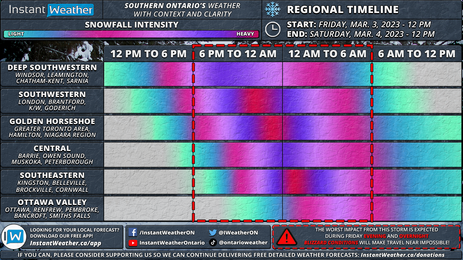
The first effects of this storm will be felt in Deep Southwestern Ontario with bands of light to moderate snowfall moving into the region just after the noon hour. Heavier snow will begin to build into Southwestern Ontario by the mid to late afternoon which is when we also expect to see the wind start to pick up.
Blowing snow and localized blizzard conditions are expected by the late afternoon in Southwestern Ontario. The temperature gradient will be extremely tight meaning some areas near the Lake Erie shoreline could mix in some ice pellets and rain later on Friday which would reduce the overall snowfall totals in the Windsor, Leamington and Chatham regions.
As we head into the dinner hour on Friday, this storm will encompass much of Southwestern Ontario as it approaches the Golden Horseshoe. Conditions are expected to quickly deteriorate just after 6 PM across the Golden Horseshoe as the snowfall rate rapidly increases from a few centimetres per hour in the late afternoon to 3-6cm/hour by the early evening.
Treacherous conditions will continue throughout the evening and into the early overnight hours with the most intense snowfall rates just before midnight. Most of the snow from this storm will come during a 6-12 hour timeframe which is expected to further enhance the impact due to blowing snow as road crews are unable to keep up with the intense snowfall rates.
For Central and Eastern Ontario, there is some disagreement on exactly how far north the bands of snow will make it into our region. Some models show a tighter gradient with the heavy snow which would lead to lighter snow for the more northern parts of Southern Ontario. The snow is expected to start by the early evening (late evening in the Ottawa Valley) and continue steadily overnight into Saturday morning.
Conditions should begin to improve by the mid to late morning on Saturday as the system exits our region. Although keep in mind that many roads will likely still be snow-covered and it could take a good portion of the weekend before everything is fully cleaned up so expect some lingering impacts throughout Saturday.

NOTE: You can click on the map to open a zoomable image which will be easier to read.
In terms of the worst impact, we expect blizzard conditions to be quite widespread affecting Sarnia, London, Hamilton, K/W, GTA, Barrie, Peterborough and Kingston. Wind gusts ranging from 50-80km/h combined with the heavy snow will lead to whiteout conditions mainly between 5 PM and 2 AM on Friday. Those near the Lake Erie shoreline and into the Niagara region could mix in some ice pellets leading to lower snowfall accumulation although a moderate impact is still expected.
While the focus of this event won’t necessarily be on the total accumulation, it will certainly be an important component. Current data suggests the highest totals will be found right around the Golden Horseshoe thanks to potential lake enhancement off the western shoreline. As such, much of the GTA and into Southeastern Ontario is on track to see between 20-30cm with maybe as much as 35-40cm in some pockets.
The more extreme totals will likely be found in the higher elevations away from the shoreline including the Dundalk Highlands (Orangeville, Guelph etc.) and just north of the GTA around Vaughan and Richmond Hill. Those near the shorelines including Toronto, Hamilton, Burlington and Oshawa will pick up closer to 20cm (or even less if we see some mixing occur).
General snowfall totals in Southwestern Ontario will range from 15 to 25cm including Sarnia, London and Goderich. The slightly lower totals are due to the potential for ice pellets along with the snow expected to be denser as temperatures will be close to the freezing mark leading to lower liquid-to-snow ratios. Between 10 to 20cm is expected along the Lake Erie shoreline in Deep Southwestern Ontario and could even end up lower than 10cm should temperatures end up warmer than expected and result in a switchover to rain.
As we have mentioned, there is a significant disagreement on the totals through Central and Eastern Ontario. Some models suggest that the Ottawa region could pick up close to 20-25cm while others show less than 10cm so there is a lot of variance in the numbers. At this point, we’re going with a widespread 10-20cm although the potential is there for up to locally 25cm. Once you get into the more northern sections of Southern Ontario including Muskoka, Bancroft and Pembroke, we are looking at around 6-12cm of snow possible although this area may fail to see much snow should the precipitation stay further south.
Here is an advertisement so we can pay the bills:
