Yet Another End of the Week Snowstorm Could Bring Up to 10-20cm of Snow to Parts of Southern Ontario
/Forecaster: Brennen Perry
Published: Wednesday, March 8, 2023
Last week at this time we were monitoring what would be an impactful snowstorm that brought blizzard conditions and up to 20-30cm of snow between Friday and Saturday. Fast forward to this week, there’s a strong feeling of déjà vu in the air as yet another snowstorm is on the horizon for Friday. Fortunately, this system isn’t expected to be anywhere near as impactful as last week’s storm and won’t be as widespread.
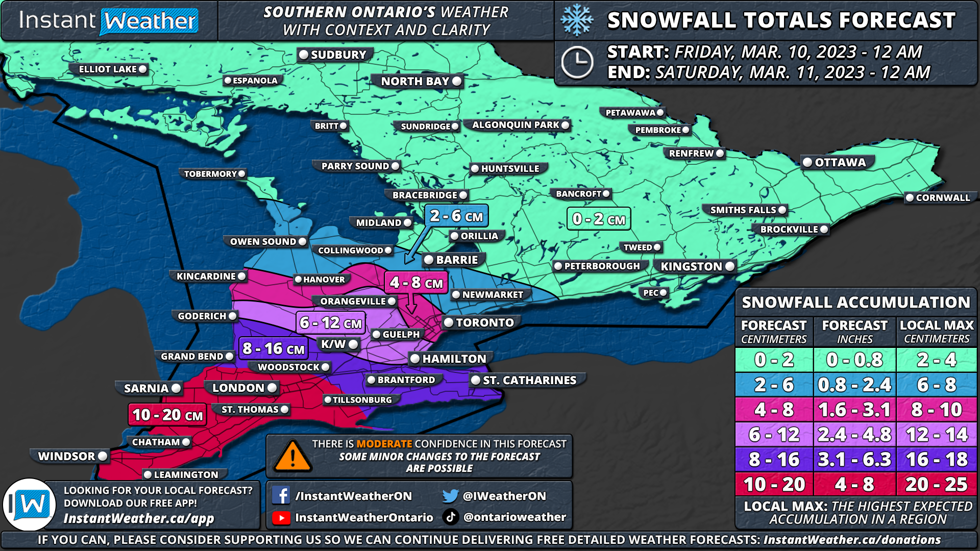
Current indications suggest that the heaviest snow will be found in Deep Southwestern Ontario including Windsor, Chatham, Sarnia and London. These areas could see between 10 and 20cm starting early Friday morning and lasting through the afternoon. Lake enhancement off Lake Ontario may lead to higher snowfall totals around Hamilton and Grimsby.
SNOWFALL TIMING
We expect that the snow will begin starting in the far southwestern portion of our region just after midnight. This means locations including Windsor and Sarnia will be the first to feel the impact of this system as it moves in from Michigan. There is some disagreement on the exact timing with some models suggesting a slightly later morning start although most models agree on it beginning sometime in the pre-dawn hours on Friday.
The heaviest snow will arrive just in time for the morning rush-hour throughout Southwestern Ontario with poor travel conditions from Windsor, Chatham, Sarnia and into London. Expect some delays and even some school bus cancellations can’t be ruled out so some children could get an early start to the March Break!
By the late morning, we will start to see the initial bands of snow moving into the Golden Horseshoe bringing steady snowfall with a focus on the more western part of the region. This will continue throughout the morning and into the afternoon. As mentioned, some locally heavier pockets of snow could develop over the higher elevations of the Niagara and Hamilton region southwest of Lake Ontario. This includes the Hamilton Mountain and Grimsby area with lake enhancement off Lake Ontario developing during the afternoon on Friday.
The snow is expected to taper off from west to east by the late afternoon and fully clear out of Southern Ontario just before the end of Friday.
SNOWFALL totals
Total snowfall accumulation will be the highest in Southwestern Ontario with a general 10 to 15cm in locations including Windsor, Leamington, Chatham, Sarnia, London and St. Thomas. Some models suggest even higher totals exceeding 15cm, so we’ve used a more comprehensive range of 10-20cm for our forecast map in this area.
The rest of Southwestern Ontario from Goderich, K/W, Hamilton and Niagara region can expect around 8-16cm of snow. Although the higher numbers (12-16cm) will be mostly found southwest of Lake Ontario where lake enhancement will boost totals.
Less snow is expected to the north with between 2-6cm across much of the GTA and northern parts of Southwestern Ontario. Little to no accumulation will be found in Central and Eastern Ontario.
Keep in mind that this forecast has a moderate level of confidence as there is some disagreement on the models on how far north the heavier snow will extend into our region. We may need to shift the totals up in the more northern part of our forecast zones on Thursday if models start to show a more northern track.
Here is an advertisement so we can pay the bills:


