Southern Ontario: Thunderstorm Outlook for Thursday, July 15, 2021

Forecast Discussion

Forecast Update: Good afternoon! We’ve reviewed the latest data this morning and we believe our map from last night still accurately depicts the risk for this afternoon and evening. Already have some non-severe thunderstorms development through Central Ontario ahead of the main event that’s expected to get going in a few hours. Concerned about the potential for one or two tornadoes through the Simcoe County, Kawartha Lakes, Muskoka, Haliburton region and up into Algonquin Park/Pembroke. Models consistently have a bullseye around this region and at the very least we can expect damaging wind gusts and large hail. The rest of the region is at risk for some widespread wind damage from a squall line that could develop late this afternoon. It will continue eastward into the early evening. We’ll keep you covered all day today with storm updates and our live stream which should be starting soon.

Original Forecast:

After many locations are just beginning to clean up from Tuesday’s storms the sweep across parts of Southern Ontario, there’s the potential for more strong severe storms during the afternoon and evening on Thursday. The areas at the highest risk of these storms include much of the same areas hit hard on Tuesday stretching from Lake Huron to the northeast through Lake Simcoe and into Central Ontario. Storms are expected to develop during the early afternoon and could pose a strong wind gust, large hail and tornado risk early in their lifespan. Current data indicates the strongest tornado threat exists through the Orangeville-Barrie-Muskoka corridor during the afternoon.

Later in the day, it appears that the isolated storms will slowly merge into one main squall line with the main risk turning towards widespread 90-100km/h damaging wind gusts. This line will track to the east and southeast reaching the GTA by the dinner hour or early evening. It will slowly weaken through the evening and should no longer pose a severe threat by the time it reaches Extreme Eastern Ontario. There is also some potential for a few isolated severe storms that may track into Deep Southwestern Ontario (Windsor, Chatham-Kent etc.) during the evening. The main risk with these storms will be strong wind gusts.

The severe risk will come to an end by the late evening although a few non-severe storms may linger past the midnight hour.

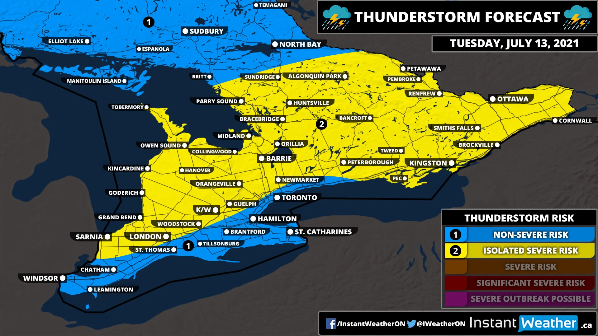
Southern Ontario: Thunderstorm Outlook for Tuesday, July 13, 2021

MAP UPDATED - July 13 @ 1 PM

MAP UPDATED - July 13 @ 1 PM

Forecast Discussion

Widespread thunderstorms are expected to affect Southern Ontario starting late Tuesday morning and continuing through the day right into the late evening hours. The environment is favourable for some of these storms to become severe throughout parts of Southwestern, Central and Eastern Ontario. Main risks with these storms include wind gusts over 90km/h and large hail perhaps as large as toonie size (~3cm).

Current data shows several discrete strong cells developing somewhere through the Owen Sound-Meaford-Midland corridor during the early afternoon and tracking to the northeast through Northern Simcoe County and Southern Muskoka. They will further strengthen as they track into the Haliburton, Bancroft and Renfrew areas where there is even the potential for one or two tornadoes.

Flooding will also be a huge issue with these storms especially with some locations seeing multiple rounds of storms over the next 12-24 hours. The highest rainfall totals are expected to the east of Georgian Bay where some localized pockets of 50-100mm are quite possible.

More storms could develop over Michigan and Lake Huron tracking into Southwestern Ontario towards the dinner hour and early evening. The exact severity of these storms is unclear due to the timing and storm mode, but some strong wind gusts and isolated severe gusts are a fair bet.

Another area of concern is over Lake Erie and the Niagara region which could also see some storm development late in the afternoon before they track across Lake Ontario and into upstate New York. They could also clip the Kingston and Prince Edward County area depending on how far north they make it.

The risk of severe storms should come to an end by midnight, but non-severe thunderstorms from the decaying storms could continue overnight and into Wednesday morning.


We'd like to thank our sponsor for this forecast; Naughty Spots PhoDography!

"If you seek heart-squeezing moments frozen in time of your furry companions you’ve come to the right place! Naughty Spots PhoDography lovingly captures the personality of furry companions all over Central Ontario. Mention seeing this ad on Instant Weather Ontario/Ontario Storm Watch for 10% off your first shoot!"

Visit www.naughtyspotsphodography.com for details!

Southern Ontario: Thunderstorm Outlook for Tuesday, July 13, 2021

SON-TStorm-Day1.jpg

Forecast Discussion

Widespread thunderstorm activity is expected across Southern Ontario during the day on Tuesday. There is the potential a few of these storms could reach severe levels extending from the Lake Huron shoreline through Central Ontario and including all of Eastern Ontario. The strongest risk will be during the afternoon and evening with the main threats being strong wind gusts and large hail. A tornado can’t be ruled out especially in parts of Eastern Ontario where the environment is favourable for isolated tornadoes, but it’s not extremely strong at this point. We’ll pinpoint the tornado risk (if it still exists) in our final map issued Monday evening.