Snow Squalls Could Bring ‘Blizzard-like’ Conditions and Bury Parts of Ontario in Up to 50cm of Snow Between Sunday and Tuesday
/
NOTE: YOU CAN CLICK ON THE MAP TO OPEN A ZOOMABLE IMAGE
Confidence is growing in a significant snow squall threat to kick off the week in the regions around Lake Huron, Georgian Bay, and Lake Superior. Snow squall activity is anticipated to start as early as Sunday evening and persist through Monday into Tuesday.
These squalls will bring the potential for rapid snowfall accumulation, with hourly rates reaching 5-10cm. Combined with strong wind gusts, it is likely to result in blowing snow, possibly even leading to localized blizzard-like conditions.
Road closures are likely, especially late Monday into Tuesday morning when the most severe conditions are expected. The highest impact from this snow squall event will extend through the corridors from Owen Sound to Goderich and Orillia to Huntsville. For Northern Ontario, the Sault Ste. Marie and Wawa area will bear the brunt of the snow squalls off Lake Superior.
Total snowfall accumulation over the next few days will be highly variable, depending on the precise location of narrow yet intense bands of lake-effect snow. These bands are expected to shift around, limiting extreme totals but affecting a wider area at some point over the next 3 days.
Combined snowfall accumulation by Tuesday evening could approach 40-50cm in localized areas. General totals throughout the typical snowbelt region will range from 15 to 30cm.
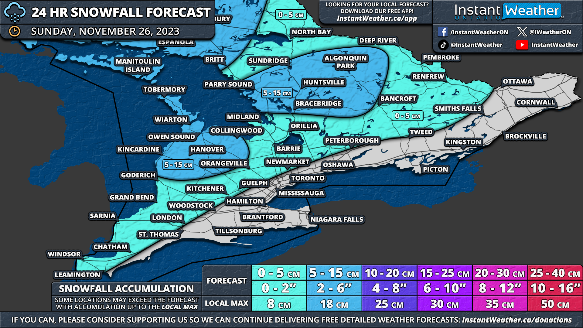
SUNDAY
NOTE: YOU CAN CLICK ON THE MAP TO OPEN A ZOOMABLE IMAGE
This multi-day snow event begins Sunday evening as a messy system is currently tracking across the province. For most of Southern Ontario, precipitation has been a mixed bag, including rain, freezing rain, ice pellets, and wet snow throughout the afternoon and evening.
Limited snowfall accumulation is expected on Sunday, except for areas east of Lake Huron and Georgian Bay. Lake enhancement could boost snowfall totals to 5-10cm (locally 15cm) by nightfall for the Grey-Bruce, Parry Sound, and Muskoka regions.

NOTE: YOU CAN CLICK ON THE MAP TO OPEN A ZOOMABLE IMAGE
Northeastern Ontario will also see some notable snowfall accumulation, with widespread accumulation of 10-15cm by Sunday's end. A small zone east of Lake Superior between Wawa and Sault Ste. Marie could experience higher totals of up to 20-25cm due to evening snow squalls.
MONDAY

NOTE: YOU CAN CLICK ON THE MAP TO OPEN A ZOOMABLE IMAGE
The lake effect snow machine ramps up early Monday with squalls developing off Lake Huron and Georgian Bay. There's model disagreement on the exact squall direction, but a westerly flow is expected initially.
The lake-effect snow will likely be disorganized and spread out initially, with bands developing across Lake Huron, crossing the Bruce Peninsula and Georgian Bay before coming onshore between Parry Sound and Port Severn.
This continues into the afternoon, with activity becoming more focused, affecting parts of Muskoka and Parry Sound. The location of the strongest squall is unclear, with one model suggesting Parry Sound to Huntsville, while another places it further south, focusing on the Port Carling and Bracebridge region.
Local snowfall amounts by Monday's end could range from 15 to 25cm, although the localized nature of these squalls means not everyone will see that much snow. Bracebridge, Port Carling, Port Sydney, Rosseau, Huntsville, and Parry Sound are included.
Additional lake effect activity is expected east of Lake Huron, with heavier snow away from the shoreline. Locally, 10-15cm, possibly even 20cm, is possible in Listowel, Hanover, and Chatsworth.

NOTE: YOU CAN CLICK ON THE MAP TO OPEN A ZOOMABLE IMAGE
Sault Ste. Marie will likely face snow squalls starting early Monday and lasting throughout the day. Local amounts could approach 20cm in the hardest-hit regions by Monday's end.
TUESDAY

NOTE: YOU CAN CLICK ON THE MAP TO OPEN A ZOOMABLE IMAGE
A shift in wind direction late Monday will cause the snow squalls to sink southward overnight into early Tuesday, intensifying further. The worst conditions are expected during the pre-dawn hours on Tuesday, with blizzard-like conditions making travel near impossible throughout a big chunk of the snowbelt east of Lake Huron and southeast of Georgian Bay.
The squalls become stationary again by late Tuesday morning, with one main squall off Georgian Bay and coming onshore somewhere between Orillia and Barrie. This squall may stretch far inland, bringing heavy snow to parts of the Kawartha Lakes and the northern Durham region.
Two main squalls off Lake Huron will be present, with the more northern band stretching from Port Elgin inland towards Hanover and Shelburne. Further south, a secondary squall will come onshore between Point Clarke and Goderich, stretching into the Listowel and Mitchell area.
Again, the overall accumulation will depend on exactly where these bands lock-in, but the heaviest snowfall will likely be found in locations including Point Clark, Wingham, Listowel, Port Elgin, Hanover, Wasaga Beach, Midland, and Port Severn by Tuesday's end. These areas have the potential for snowfall totals ranging from 20 to 30cm, with locally higher amounts not out of the question.
Surrounding regions east of Lake Huron and around Lake Simcoe can expect 10 to 25cm, depending on the squalls' location and how far they stretch inland. Even parts of the Greater Toronto Area (GTA), particularly in the west end, could see a quick 5-10cm with the snow squalls off Lake Huron.
The Tuesday forecast should be considered preliminary as we await developments on Monday. Adjustments might be necessary as more higher-resolution model data become available.
Snow squalls may persist into Wednesday, although it's unclear which regions could be affected; this will be covered in a separate forecast.
OVERALL IMPACT

NOTE: YOU CAN CLICK ON THE MAP TO OPEN A ZOOMABLE IMAGE
With the snow squalls expected to shift over the next few days, extreme accumulation usually associated with stationary squalls is less likely. However, this will allow for a more widespread impact as the snow is more spread out.
An expansive zone east of Lake Huron from Owen Sound to Listowel could see 3-day snowfall totals between 25-40cm, locally up to 50cm. The story is similar to the eastern shoreline of Georgian Bay, with Parry Sound, Muskoka, and Northern Simcoe County in the bullseye.
Away from these areas, expected accumulation drops off rapidly, subject to more uncertainty depending on how far inland the squalls extend.
Around 15 to 30cm is possible for locations including Goderich, Stratford, Wiarton, Meaford, Barrie, Orillia, Lindsay, and Haliburton. Regions just west of the Golden Horseshoe, including Kitchener, Guelph, and Brantford, could see locally up to 10-20cm if the snow squall activity reaches them.
Again, not everyone will see significant totals, and some may not see any snow, given the extremely localized nature of these bands. It's challenging to pinpoint exactly where the squalls will end up.
Less than 5cm of snow is expected for most of the Golden Horseshoe, Eastern Ontario, and Deep Southwestern Ontario throughout the next 3 days.

NOTE: YOU CAN CLICK ON THE MAP TO OPEN A ZOOMABLE IMAGE
In Northern Ontario, widespread snowfall totals between 10-20cm are expected on Sunday night and Monday.
More intense snowfall is expected along the eastern shoreline of Lake Superior, with 25-40cm possible between Wawa and Sault Ste. Marie due to expected snow squall activity on Monday.
