Winter Storm Threat Looms for Ontario With Up to 30cm of Snow and 60mm of Rain by Thursday

NOTE: YOU CAN CLICK ON THE MAP TO OPEN A ZOOMABLE IMAGE

The beginning of April in Ontario is setting the stage for a dramatic shift in weather, as a moisture-laden system promises a variety of conditions across the region. This shift includes the potential for flooding rains, with predictions of 40 to 60mm of rain in parts of the Golden Horseshoe.

In addition, areas of Central, Eastern, and Northern Ontario are on track for significant snowfall, with totals ranging from 20 to 35cm in the most affected areas!

As outlined in our previous forecasts, this bout of active weather kicked off with strong wind gusts on Tuesday afternoon, expected to persist into the night.


GOOGLE AD (NOT ENDORSED BY INSTANT WEATHER)

With the wind gradually subsiding, our attention now shifts to the substantial moisture being pumped into our region from the Gulf of Mexico. Initially, this precipitation will begin as heavy rain, with intense downpours expected overnight and into Wednesday morning across the Greater Toronto Area, extending into Central and Eastern Ontario.

However, by late Wednesday, colder air from the northwest will sweep in, prompting a gradual transition from rain to wet snow by the late afternoon in parts of Central and Eastern Ontario. Northeastern Ontario, already under colder air by the morning, may experience snow for the duration of this event.

The challenge in forecasting this system lies in the temperatures hovering near the freezing point, significantly impacting snow accumulation. Additionally, model predictions vary on the timing of the transition from rain to snow, some suggesting it won't occur until late Wednesday evening, while others indicate it will occur around 2 to 5 PM.

By Wednesday night, most regions, including the Golden Horseshoe, are expected to have transitioned to wet snow, with light to moderate snowfall persisting into Thursday morning and afternoon, concluding by Thursday evening.


GOOGLE AD (NOT ENDORSED BY INSTANT WEATHER)

NOTE: YOU CAN CLICK ON THE MAP TO OPEN A ZOOMABLE IMAGE

Elevation will be a crucial determinant of snowfall totals, with the highest accumulations forecasted southwest of Ottawa in Eastern Ontario's elevated areas. This includes Bancroft, Barry’s Bay, Algonquin Park, and Renfrew, with expected snowfall totals ranging from 20 to 35cm by Thursday's end.

For the Ottawa Valley, including Ottawa, Cornwall, Brockville, and Pembroke, snowfall totals are more uncertain, ranging from 10 to 25cm. This variability will depend on local dynamics and the ability of snow to stick to the ground. There is the potential that some areas will exceed our forecast if the snow can stick more efficiently to the ground.

Further south and westward, snowfall totals are expected to range from 5 to 15cm, including Kingston, Peterborough, Huntsville, and Sundridge. Local areas north of the Greater Toronto Area, particularly along the higher elevations of the Oak Ridges Moraine and Dundalk Highlands, may also see up to 10 to 15cm. This forecast is heavily dependent on temperatures, which may not drop below freezing until Thursday morning, affecting accumulation.

Areas east of Georgian Bay and away from Lake Ontario's shoreline are likely to exceed 5cm but should remain under 10cm. Regions directly along the Lake Ontario shoreline and parts of Southwestern Ontario will experience less than 5cm of snow, as rain will dominate these areas.


GOOGLE AD (NOT ENDORSED BY INSTANT WEATHER)

In addition to significant snowfall in Central and Eastern Ontario, significant rainfall is anticipated along Lake Ontario's shoreline, including Prince Edward County, Oshawa, Toronto, Mississauga, Burlington, Hamilton, and Grimsby, with potential totals ranging from 40 to 60mm. This rapid accumulation, especially in urban areas prone to flash flooding, poses a substantial flooding risk.

Rainfall totals for the rest of the Golden Horseshoe, extending to the Dundalk Highlands and the Bruce Peninsula, are projected to range from between 30 to 50mm. Further north and east, where more snow is expected to mix in, rainfall totals of 20 to 40mm are likely.

Southwestern Ontario is expected to see lower rainfall totals of 10 to 30mm, with Deep Southwestern Ontario receiving less than 15mm.


GOOGLE AD (NOT ENDORSED BY INSTANT WEATHER)

NOTE: YOU CAN CLICK ON THE MAP TO OPEN A ZOOMABLE IMAGE

In Northern Ontario, heavy snow is the main concern, with the highest totals just north of Sudbury, anticipating 20 to 35cm of snow from Wednesday morning through Thursday afternoon.

For Sudbury and North Bay, snowfall predictions range from 10 to 25cm. Lower amounts are expected towards Georgian Bay due to rain mixing in, while totals will decrease sharply further north and west due to limited moisture.

Messy Week Ahead as Multiple Rounds of Heavy Snow and Freezing Rain Target Southern Ontario Starting Tuesday

NOTE: YOU CAN CLICK ON THE MAP TO OPEN A ZOOMABLE IMAGE

After a mild start in December, the new year has brought a shift in the weather pattern across Southern Ontario. January has definitely felt more like winter, with our first prolonged deep freeze leading to several instances of snow squalls in the past few weeks.

However, it seems the winter spell is about to break as we welcome milder air for the final days of January. The warm-up won't be uniform across the region, though. For instance, the Ottawa Valley and northern parts of Central Ontario will continue to experience colder temperatures, with overnight lows below -10°C and wind chills near -20°C for much of the week.

In contrast, areas in Southwestern Ontario and around the Golden Horseshoe are expected to see temperatures closer to, or even slightly above, the freezing mark later this week.

Several systems are forecast to move across Southern Ontario in the coming days. With temperatures hovering around freezing, these systems are likely to bring a mix of winter weather, including heavy snow, ice pellets, freezing rain, and even some regular rain.


GOOGLE AD (NOT ENDORSED BY INSTANT WEATHER)

The first system is set to impact Southern Ontario late Monday, continuing through Tuesday. This could affect the Tuesday morning commute, particularly in Southwestern Ontario and the Greater Toronto Area.

Current predictions indicate that precipitation will primarily be heavy snow, stretching from Lake Huron across the Golden Horseshoe and into southern parts of Central and Eastern Ontario. By Tuesday's end, total snowfall could reach up to 10cm in some areas.

A more complex situation is expected further south in Deep Southwestern Ontario and along the Lake Erie shoreline. A mix of snow, ice pellets, and prolonged freezing rain could lead to icy road conditions in this region.


GOOGLE AD (NOT ENDORSED BY INSTANT WEATHER)

Light snow and ice pellets have already started in Southern Ontario as of Monday afternoon, ahead of the main system. This is expected to taper off through the evening, though some patchy freezing drizzle could persist around the Lake Erie shoreline.

The initial bands of precipitation associated with the system will reach the Windsor area around midnight, with freezing rain being the primary concern. This risk will continue overnight and spread to Chatham and Sarnia by mid-morning Tuesday, making for potentially icy roads and delays. School bus cancellations are also a possibility due to the freezing rain threat.

By lunchtime Tuesday, the slow-moving system should reach London, Kitchener, Hamilton, and Toronto. It will likely start as light to moderate snowfall, continuing into the evening. Although the snowfall rates may not be intense, the prolonged nature of the event means that even a centimetre or two per hour will accumulate significantly over 6-12 hours.

Later in the afternoon, areas in Deep Southwestern Ontario and along the Lake Erie shoreline should warm up enough to transition from freezing rain to regular rain. A similar changeover to ice pellets and freezing rain is anticipated in the London to Hamilton corridor by evening, possibly resulting in slightly lower snowfall totals compared to areas further north.


GOOGLE AD (NOT ENDORSED BY INSTANT WEATHER)

Snow is expected to begin in the southern part of Central and Eastern Ontario, from Barrie to Kingston, in the late afternoon or early evening, continuing overnight into Wednesday morning. Further north, areas like Huntsville, Algonquin Park, and Ottawa can expect less snow, as the heaviest precipitation is forecast to remain south.

The system should start clearing from west to east just after midnight and exit the province by late Wednesday morning. However, a brief respite in precipitation will be followed by another wave of moisture from the southwest late Wednesday.

This next system looks to bring more rain for Southwestern Ontario and the Golden Horseshoe, while Central and Eastern Ontario could face a prolonged risk of freezing rain lasting into Thursday. Further details on this will be provided in a separate forecast.

The impact of the first system will vary significantly. Regions east of Lake Huron through the Kitchener area and around the Greater Toronto Area are likely to see mostly snow, with additional accumulations of 6 to 12cm by the end of Tuesday. Lower snowfall amounts of 2 to 6cm are expected further north in parts of Central and Eastern Ontario.


GOOGLE AD (NOT ENDORSED BY INSTANT WEATHER)

NOTE: YOU CAN CLICK ON THE MAP TO OPEN A ZOOMABLE IMAGE

The situation becomes more complex southwestward, with a zone stretching from Sarnia through London to the Hamilton/Niagara region likely to experience a mix of ice pellets and snow. A few centimetres of ice pellets, along with up to 4-8cm of snow, is possible here. Brief freezing rain later on Tuesday shouldn't be ruled out as the mixing line moves northward.

In Deep Southwestern Ontario and along the Lake Erie shoreline, the primary risk is ice pellets and freezing rain. The precipitation will likely start as ice pellets early Tuesday, transitioning to freezing rain by late morning or early afternoon. Some rain may also occur in the evening as temperatures rise above freezing. Total accumulations are hard to gauge, but expect around 2-6cm of snow, followed by up to 2cm of ice pellets, and then several hours of freezing rain.

The Windsor and Chatham areas are forecast to see mostly freezing rain from this system, with ice accumulation up to 2-4mm before transitioning to regular rain. There could also be 10-15mm of rain from the system after the switchover occurs.

Blizzard Risk for Southern Ontario on Friday; When Will It Arrive?

Southern Ontario is currently on track to see a high-impact snowstorm starting Friday evening. This storm will bring a brief, but intense burst of snow leading to blizzard conditions in many areas.

Here's a region-based breakdown of the estimated timing. Please note that these are estimates, and actual start times may vary by a few hours. However, this should give you a general idea of when to expect the worst conditions.


FULL FORECAST


The blizzard is expected to begin in Deep Southwestern Ontario in the late afternoon or early evening. Areas like Windsor, Chatham, and Sarnia will likely see conditions worsen between 5-7 PM.

Once the blizzard conditions arrive, they will last for one or two hours before gradually reducing in intensity with moderate snow continuing into Saturday. Although the wind will remain a concern throughout the night so expect some blowing snow.


GOOGLE AD (NOT ENDORSED BY INSTANT WEATHER)

As the heavy snow band moves northeast, it will reach the London, Kitchener, and Goderich area shortly after dinner. The GTA, Hamilton, and Niagara regions should brace for the blizzard around 8-9 PM. Note that some of these areas might have mixed precipitation, which could reduce the severity of the blizzard.

Later in the evening, Central Ontario, including Simcoe County, Kawartha, Peterborough, and Muskoka, will experience heavy snow and strong winds. This is expected to start between 9-10 PM in the south and around 11 PM in the northern areas.


GOOGLE AD (NOT ENDORSED BY INSTANT WEATHER)

Eastern Ontario, including Kingston and the Ottawa Valley, will likely see the blizzard start around 10 PM and around midnight, respectively.

Since it's not feasible to include every location in our graphic, we recommend using the closest listed location for guidance.

Intense Blast of Snow on Friday Evening Could Bring Blizzard Conditions & Up to 20-30cm of Snow to Parts of Ontario

NOTE: YOU CAN CLICK ON THE MAP TO OPEN A ZOOMABLE IMAGE

Confidence remains high regarding a snowstorm set to impact Southern and Northeastern Ontario from late Friday into Saturday. Despite a slight reduction in the predicted snowfall totals, we're still on track for a high-impact event. This event will feature several hours of intense snowfall and strong wind gusts, which are likely to result in blizzard conditions and blowing snow.

Currently, we're anticipating a widespread snow accumulation of 15-30cm across Southern Ontario. However, areas closer to the Lake Ontario and Erie shorelines may see lower amounts, as a switch to rain is expected to limit the overall accumulation.


GOOGLE AD (NOT ENDORSED BY INSTANT WEATHER)

There's a degree of uncertainty regarding the extent of warm air intrusion, leading to discrepancies in the snowfall totals projected by different models. To account for this variance, we've opted for broader snowfall ranges instead of predicting a definitive outcome of either warm or cold air dominance.

The likelihood of warmer air influencing the weather, followed by a rapid cooldown early Saturday, introduces the risk of a flash freeze. Areas along the Lake Erie and Ontario shorelines might experience slushy conditions late Friday night due to temperatures rising to the mid-single digits and mixing with rain. This slush is expected to freeze quickly as colder air moves in behind the system, potentially leading to icy road conditions on Saturday morning.

We expect the storm's initial band of snow to hit between 4-6 PM on Friday, starting in Extreme Southwestern Ontario. This band is poised to deliver a short, intense burst of heavy snowfall, with rates of 4-8cm per hour, possibly accompanied by thundersnow.

Accompanying strong wind gusts, which could reach up to 90km/h in some localities, are expected to create hazardous driving conditions, particularly in Southwestern Ontario, the Golden Horseshoe, and parts of Central Ontario, where localized blizzard conditions may occur.

This heavy snow will progress through Southwestern Ontario, impacting London, Kitchener, and Hamilton by early evening. It will reach the Greater Toronto Area later in the evening, and eventually spread northeast to Central and Eastern Ontario, continuing overnight into early Saturday.

While the most intense snowfall will be brief, moderate snow is expected to persist behind the initial band throughout the night into Saturday. Around the Lake Ontario and Erie shorelines, a surge of warmer air Friday night into Saturday morning could result in a temporary changeover to rain, especially affecting snowfall totals in the Niagara region and parts of the Greater Toronto Area near the lakeshore.


GOOGLE AD (NOT ENDORSED BY INSTANT WEATHER)

There's increased confidence that warmer air will move in along the Lake Erie and Ontario shorelines after the intense snow band passes in the evening. This could lead to reduced snowfall totals in the Niagara region and parts of the Greater Toronto Area (GTA) near the lakeshore.

Higher-resolution models suggest that snowfall accumulation may vary significantly based on elevation. Therefore, areas like the Dundalk Highlands and along the Oak Ridges Moraine north of the GTA are likely to receive higher snowfall totals.

Steady snowfall is expected to persist throughout Southern Ontario on Saturday, with the most intense snow occurring in Eastern Ontario. The arrival of much colder air in the wake of the system will also trigger lake-effect snow squalls off Georgian Bay and Lake Huron.

These snow squall conditions are expected to continue into the next week, with the cold Arctic air remaining over our region. This could result in significant snowfall accumulations throughout the week in areas including Goderich, Kincardine, Hanover, Owen Sound, Wiarton, Barrie, Orillia, Midland, Bracebridge, Huntsville, Parry Sound, Britt, and Sundridge.

It's important to note that snowfall totals from this event will be highly variable, influenced by local factors that are difficult to precisely predict. Therefore, app-based forecasts, including ours, may vary from the forecast presented here. Our approach involves providing a broader range to account for various potential scenarios.


GOOGLE AD (NOT ENDORSED BY INSTANT WEATHER)

NOTE: YOU CAN CLICK ON THE MAP TO OPEN A ZOOMABLE IMAGE

We believe the hardest-hit regions will be parts of Eastern Ontario, specifically between Peterborough and Ottawa. The entrenched colder air in this area is expected to prevent any mixing, leading to significant snowfall.

The intense snow band on Friday could stall over Eastern Ontario for several hours, weakening gradually. Snowfall totals in this region are anticipated to range from 20 to 35cm, though localized areas could receive up to 40cm by the end of Saturday.

Central and Eastern Ontario, away from the Lake Ontario shoreline, are projected to receive about 15 to 25cm of snow. However, local accumulations could exceed 30cm, particularly in elevated regions through Orangeville, Shelburne, and York Region.

Areas around Georgian Bay, including Barrie, Orillia, and Muskoka, are expected to underperform in terms of snow accumulation. We're forecasting 10 to 20cm to account for this potential dry slot.

NOTE: YOU CAN CLICK ON THE MAP TO OPEN A ZOOMABLE IMAGE

The forecast becomes more complex further southeast into the Golden Horseshoe. Away from the shorelines of Lake Erie and Ontario, snowfall totals are likely to exceed 10cm and could approach 20cm in some areas.

Closer to the shorelines, we anticipate accumulation ranging from 5 to 15cm. This broad range accounts for the uncertainty, with areas right along the shoreline likely seeing closer to 5cm, while a few kilometres inland could receive up to 15cm.


GOOGLE AD (NOT ENDORSED BY INSTANT WEATHER)

NOTE: YOU CAN CLICK ON THE MAP TO OPEN A ZOOMABLE IMAGE

The tight gradient makes it challenging to represent on a map, hence the larger range. This 5 to 15cm range also applies to much of Deep Southwestern Ontario, including Windsor and Sarnia, with most of the snowfall occurring within a few hours late Friday afternoon.

The Lake Erie shoreline into the Hamilton region is expected to receive less than 10cm of snow. Meanwhile, the Niagara region might see the least amount, with less than 5cm possible.

NOTE: YOU CAN CLICK ON THE MAP TO OPEN A ZOOMABLE IMAGE

In Eastern Ontario, significant snowfall totals are expected to be widespread, with the 20-35cm zone southwest of Ottawa. The City of Ottawa itself is likely to see around 15 - 25cm, though totals approaching 30cm cannot be discounted.

Further southeast, the warm air will influence snowfall in the Kingston, Brockville, and Cornwall areas early Saturday morning, likely limiting totals to a general 10-20cm. However, areas right along the international border, including Cornwall and Brockville, might not even reach the 10cm mark.


GOOGLE AD (NOT ENDORSED BY INSTANT WEATHER)

NOTE: YOU CAN CLICK ON THE MAP TO OPEN A ZOOMABLE IMAGE

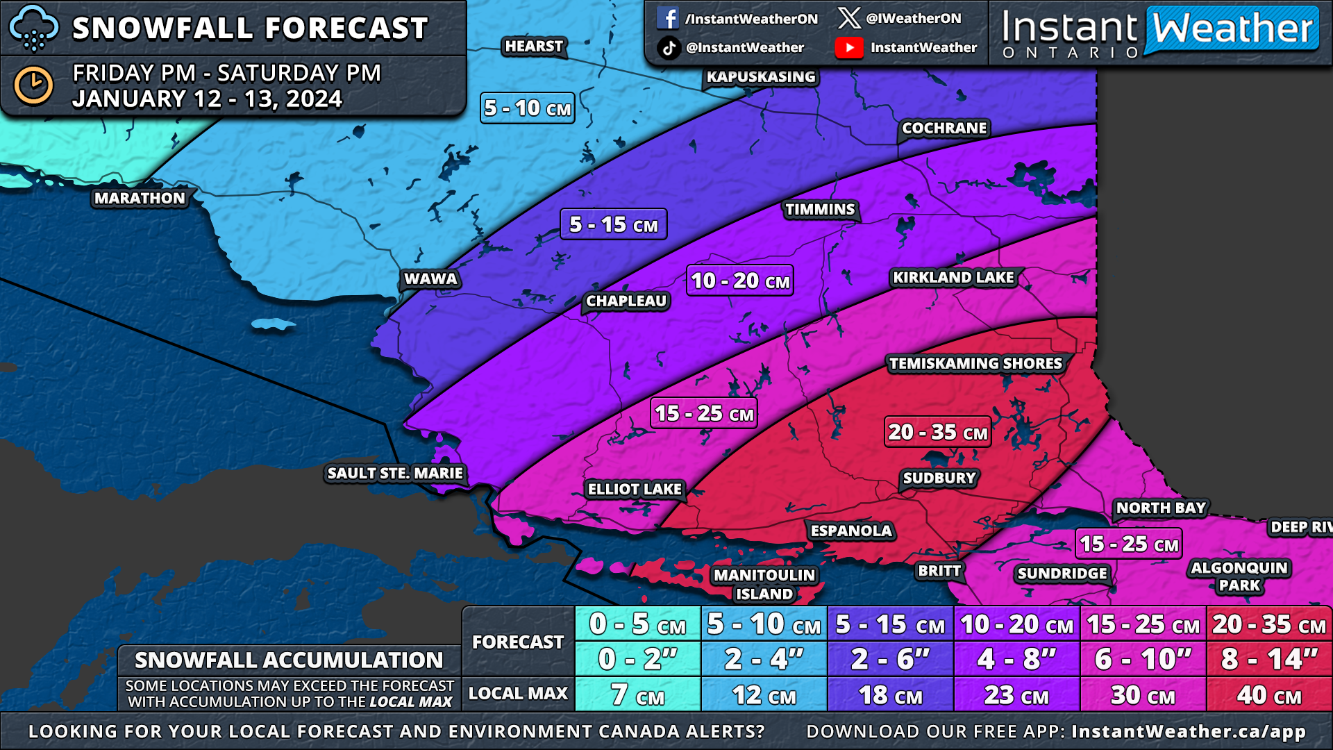
Northeastern Ontario is also set to be affected by this event, with over 20cm of snow forecasted starting late Friday evening. The heaviest band of snow is expected to move across Manitoulin Island and into the Sudbury region early Saturday morning, with snowfall rates of 3-6cm per hour.

Blowing snow and localized blizzard conditions are a concern during the morning hours across the southern portion of Northeastern Ontario, including Sudbury and North Bay. Moderate snowfall is expected to continue across Northeastern Ontario throughout Saturday, tapering off later in the evening.

The highest totals are forecasted from Manitoulin Island through Elliot Lake, Sudbury, and North Bay, with 20 to 35cm of snow possible. Locally, up to 40cm can't be ruled out, especially given the intensity of the morning snowfall.

Less snow is expected further northeast, with around 10-20cm for Sault Ste. Marie, Chapleau, and Timmins. Even lower amounts, ranging from 5 to 15cm, are possible from Wawa to Kapuskasing.


GOOGLE AD (NOT ENDORSED BY INSTANT WEATHER)

Winter Storm Threatens Tuesday Evening Commute Across Ontario Including the GTA; Significant Snowfall to the North With Up to 35cm Possible

NOTE: YOU CAN CLICK ON THE MAP TO OPEN A ZOOMABLE IMAGE

The New Year in Ontario has been notably active, marked by several snowy systems over the past week. This trend is expected to continue with a significant winter storm approaching, bringing heavy snow, ice pellets, and some freezing rain beginning Tuesday morning.

We are also closely monitoring a potential high-impact storm this weekend, which may deliver a more substantial impact, focusing on heavy snow rather than mixed precipitation.

More details about the looming snowstorm threat will be provided in the coming days. For now, our attention is on the imminent winter storm, which presents a complex forecast involving various winter weather threats. Weather models have struggled to determine the exact path of this system, but there is broad agreement as we approach 24 hours before the system's arrival.


GOOGLE AD (NOT ENDORSED BY INSTANT WEATHER)

The heaviest snowfall is expected to occur primarily in Northeastern Ontario, extending southward into Central and Eastern Ontario. In these areas, precipitation is likely to remain frozen for most of the event, resulting in higher snowfall totals. By early Wednesday, the hardest-hit areas could see over 20cm of snow, with some locales receiving more than 30cm.

In the rest of Southern Ontario, the scenario is more complex. We anticipate wet snow in most regions on Tuesday morning, transitioning to rain as temperatures rise, beginning in Deep Southwestern Ontario and around the Lake Huron shoreline.

The speed of the warmer air's advance northward creates uncertainty regarding overall snowfall accumulation. Strong wind gusts accompanying the icy mix may reduce visibility and cause blowing snow.

By Tuesday afternoon and evening, a large portion of Southwestern Ontario and the Golden Horseshoe is expected to shift to ice pellets and then rain. This transition may coincide with peak evening rush hour, potentially leading to hazardous travel conditions. We advise preparing for extended travel times or considering staying off the roads until conditions improve.


GOOGLE AD (NOT ENDORSED BY INSTANT WEATHER)

NOTE: YOU CAN CLICK ON THE MAP TO OPEN A ZOOMABLE IMAGE

To clarify the timeline of the various precipitation shifts, we will detail the expected impact of this winter storm for each part of Tuesday and Wednesday.

Focusing on the timeline rather than the amounts is crucial, as accumulating snow at the storm's onset will likely be washed away by rain, making accurate measurement challenging. The rapid shifts in precipitation types, leading to icy and slushy road conditions, are the main threat of this winter storm.

The storm will begin early Tuesday morning as initial bands of precipitation cross into Deep Southwestern Ontario. Heavy wet snow is expected in Windsor, Chatham, Sarnia, London, and the Niagara region, transitioning to rain by late morning.

Further north, colder air will result in more prolonged snow across the Golden Horseshoe and westward through the Kitchener region. Ice pellets may mix in, especially along the Lake Ontario shoreline and south of the Hwy 401 corridor.


GOOGLE AD (NOT ENDORSED BY INSTANT WEATHER)

NOTE: YOU CAN CLICK ON THE MAP TO OPEN A ZOOMABLE IMAGE

As the afternoon progresses, the storm will intensify across Southern Ontario. Areas in Deep Southwestern Ontario and along the Lake Erie shoreline into the Niagara region will have switched to rain, minimizing the impact.

There is uncertainty in the Lake Huron shoreline and the Greater Toronto Area, where precipitation types will vary due to slight temperature differences.

Areas closest to the shoreline, including Hamilton, Burlington, Mississauga, and Toronto, will see a mix of ice pellets and snow during the early afternoon. However, by late afternoon, some rain is expected to mix in.

Regions north of the Hwy 401 corridor are likely to experience continued heavy snow mixed with ice pellets at times. Combined with strong wind gusts of 60-80km/h, travel could be difficult due to blowing snow and ice pellets.

A slight risk of brief freezing rain exists in this area, although sustained freezing rain is unlikely. The more likely progression will be from snow to ice pellets to rain.

Heavy snow will also affect Central Ontario around Lake Simcoe and eastward along the Lake Ontario shoreline into Eastern Ontario. Expect several hours of heavy snow throughout the afternoon.

Those in the Quebec border area and the Ottawa Valley will see the first snow bands by late afternoon, starting with lighter snow and intensifying later.


GOOGLE AD (NOT ENDORSED BY INSTANT WEATHER)

NOTE: YOU CAN CLICK ON THE MAP TO OPEN A ZOOMABLE IMAGE

By evening, warmer air will begin to replace the cold air, leading to a wider transition from frozen precipitation to rain. Southwestern Ontario and the Golden Horseshoe will have mostly switched to rain.

In southern parts of Central and Eastern Ontario, snow will persist into the early evening, potentially mixing with rain near midnight.

Heavy snow will continue for the Quebec border and Ottawa Valley regions throughout the evening. Ice pellets may mix in, extending from north of Parry Sound through Huntsville to the Smiths Falls and Cornwall areas.

Northeastern Ontario is expected to see persistent heavy snow from late Tuesday afternoon through the night. Little mixing is anticipated in this area.


GOOGLE AD (NOT ENDORSED BY INSTANT WEATHER)

NOTE: YOU CAN CLICK ON THE MAP TO OPEN A ZOOMABLE IMAGE

The storm will persist into early Wednesday, primarily affecting northern parts of Central and Eastern Ontario. South of a line from Bracebridge to Smiths Falls is expected to switch to rain by midnight.

Heavy snow will continue in the Ottawa Valley and Northeastern Ontario. By mid-morning, some mixing, including ice pellets and potentially freezing rain, is expected.

By sunrise, most of Southern Ontario will have switched to rain, while snow continues in Northeastern Ontario. The Ottawa region may not experience this transition if warmer temperatures fail to displace the cold air. Wednesday morning's commute in Eastern Ontario, especially the Ottawa Valley, is likely to be challenging.

As the system leaves the region, temperatures are expected to drop below freezing by early Wednesday morning in Southwestern Ontario and late morning or early afternoon in the rest of Southern Ontario. This will result in a transition back to wet flurries later on Wednesday, although significant accumulation is unlikely.


GOOGLE AD (NOT ENDORSED BY INSTANT WEATHER)

NOTE: YOU CAN CLICK ON THE MAP TO OPEN A ZOOMABLE IMAGE

While the variety of precipitation types is a key story of this storm, overall snowfall accumulation in some areas will resemble a classic snowstorm rather than a messy winter storm.

Starting with the least affected region, Deep Southwestern Ontario and the Niagara region are expected to see less than 5cm of snowfall, primarily on Tuesday morning before being washed away by rain.

Snowfall totals along the Hwy 401 corridor from London through Hamilton to the GTA are expected to be around 5 to 10cm early on Tuesday before switching to rain. This forecast is tricky, as slight temperature variations can significantly affect snowfall amounts. Thus, focus less on specific amounts in this region.

Areas north of the Hwy 401 corridor and away from the Lake Ontario shoreline are likely to see prolonged heavy snow throughout Tuesday morning and afternoon. Snowfall totals could reach 10-15cm in some areas, especially in higher elevations around the Dundalk Highlands, Kitchener, and Guelph regions, where some models suggest localized totals may exceed 15cm.


GOOGLE AD (NOT ENDORSED BY INSTANT WEATHER)

This zone, encompassing much of southern Central and Eastern Ontario, has more variance, leading to a wider range of 5cm to 15cm in snowfall totals. This forecast acknowledges the uncertainty in this area, providing a complete picture rather than a definitive prediction.

Further north, snowfall totals of 10 to 20cm are expected from Parry Sound through Muskoka to the Tweed and Cornwall areas.

Even higher totals are anticipated in northern Central Ontario, including Sundridge, Bancroft, and the Ottawa Valley, with a general range of 15-25cm possible. Localized pockets may even see up to 30cm.

The Algonquin Park, Renfrew, and Pembroke areas are forecasted to be the worst hit in Southern Ontario, with expected snowfall between 20 to 35cm.


GOOGLE AD (NOT ENDORSED BY INSTANT WEATHER)

In addition to snowfall, significant rain and wind are associated with this system, particularly in the south. Rainfall totals will range from 30 to 50mm across Deep Southwestern Ontario, along the Lake Erie shoreline, and into parts of Eastern Ontario north of Lake Ontario.

Rainfall totals will decrease further north, with around 20 to 30mm expected along the Lake Huron shoreline and into the GTA near Lake Ontario. For southern parts of Central and Eastern Ontario, rainfall totals between 10 to 20mm are expected, but actual precipitation will be higher when melted snow is considered, raising flooding concerns.

Less than 10mm of rain is anticipated for more northern parts of Central and Eastern Ontario, as they are likely to remain predominantly on the cold side of the storm.

Strong to damaging wind gusts are also a risk during Tuesday afternoon and evening. While there is some disagreement on the intensity, some models suggest gusts could approach 90-100km/h around the Lake Erie shoreline, Niagara region, and Prince Edward County.

For the rest of Southwestern Ontario into the Golden Horseshoe, wind gusts will range from 50 to 70 km/h, with a slight chance of 70-85 km/h gusts if the more intense model proves accurate.


NOTE: YOU CAN CLICK ON THE MAP TO OPEN A ZOOMABLE IMAGE

For Northeastern Ontario, the event will primarily be a snowstorm, starting Tuesday afternoon and continuing into Wednesday afternoon.

Snowfall totals are expected to be significant, with the hardest-hit regions from Manitoulin Island through Sudbury, North Bay, and into the Kirkland Lake region anticipating 20 to 35cm, with some areas possibly reaching 40cm.

Lower amounts are forecasted further west, with 15 to 25cm expected in areas including Elliot Lake, Timmins, and Cochrane.

Closer to Lake Superior, including Sault Ste. Marie, Wawa, and Kapuskasing, around 10 to 15cm of snow is expected, although this may vary by location. For a more detailed forecast, refer to the accompanying map.

In summary, this winter storm brings a mix of precipitation types across Ontario, with varying impacts depending on the region. The forecast includes heavy snow, rain, and strong winds, with significant snowfall in certain areas. Residents should stay informed and prepare for potentially hazardous travel conditions.

Parade of Snowstorms Take Aim at Ontario Over the Next Week Beginning With Up to 15-20cm of Snow This Weekend

NOTE: YOU CAN CLICK ON THE MAP TO OPEN A ZOOMABLE IMAGE

Winter in 2023 started sluggishly, but as the New Year unfolds, Ontario is witnessing a dramatic shift in weather patterns. The mild conditions that prevailed in late December have been replaced by colder air.

This transition is not just a mere drop in temperatures; it's also bringing a series of snowy systems. Over the coming week, these systems are poised to bring considerable snowfall to various regions across the province.


GOOGLE AD (NOT ENDORSED BY INSTANT WEATHER)

The first significant snowfall is expected over the weekend, thanks to two distinct weather systems. In the north, a system originating from the US Midwest will traverse Northern Ontario starting Saturday morning.

This will result in continuous snowfall across both Northwestern and Northeastern Ontario throughout the day. By Sunday morning, snow accumulations could reach 15-20cm in some areas.

Simultaneously, a robust system from the US East Coast is anticipated to make its way northward. The northwestern fringes of this system are expected to cross into Canada by late Saturday afternoon. However, there remains some uncertainty regarding its exact path, particularly as it interacts with the northern precipitation.

This uncertainty may affect the total snowfall, but the highest accumulations are likely in Extreme Eastern Ontario, along the St. Lawrence River. Some regions here might witness up to 15cm or more of fresh snow by the weekend's end. Additionally, lake enhancement along the western shores of Lake Ontario could result in up to 10cm of snowfall in parts of the Golden Horseshoe area.

Yet, this is merely the beginning. Another potential snowstorm, tracking through our region from late Tuesday into Wednesday, is under close observation. While there's significant uncertainty about this system's development, it's highly probable that some areas in Ontario will receive over 30cm of snow.


GOOGLE AD (NOT ENDORSED BY INSTANT WEATHER)

NOTE: YOU CAN CLICK ON THE MAP TO OPEN A ZOOMABLE IMAGE

Snow has already started in Northwestern Ontario, near the international border, as of Friday evening. This snowfall is expected to intensify overnight and continue into Saturday morning. During these hours, the steady snow will gradually spread eastward, reaching Northeastern Ontario by the afternoon. Minor lake enhancement near Lake Superior might result in slightly heavier snowfall rates.

As we progress into Saturday night and early Sunday, the snowfall will start to diminish, beginning near the Manitoba border and extending to the rest of Northwestern Ontario by sunrise. In the east, snow is expected to persist through early Sunday but will gradually weaken by the afternoon.

The heaviest snowfall totals across Northern Ontario will be quite extensive. In Northwestern Ontario, the greatest accumulations are expected along the international border, extending east to Thunder Bay and along the Lake Superior shoreline. Here, snowfall is generally forecasted to range from 15 to 20cm, with potential local higher amounts, especially near Lake Superior, where the lake effect might cause uneven snow distribution.

Toward the Manitoba border, lesser snow is anticipated, with totals between 10 to 20cm expected for areas like Kenora, Dryden, and Red Lake.


GOOGLE AD (NOT ENDORSED BY INSTANT WEATHER)

NOTE: YOU CAN CLICK ON THE MAP TO OPEN A ZOOMABLE IMAGE

In contrast, Northeastern Ontario will see a more confined area with 15-20cm of snow, primarily east of Lake Superior due to lake enhancement effects. Broader regions, including Timmins, Kapuskasing, Kirkland Lake, and Sudbury, are likely to receive 10 to 15cm.

The southern areas along the Georgian Bay shoreline, such as North Bay and Manitoulin Island, will experience lower accumulations, ranging from 5 to 10cm.


GOOGLE AD (NOT ENDORSED BY INSTANT WEATHER)

As the snow exits in the north, attention shifts to a secondary system poised to brush Southern Ontario's eastern edges. This snowfall is expected to start late Saturday afternoon, beginning in the Niagara region and gradually encompassing Eastern Ontario by night.

The interaction of this storm with the northern system adds an element of unpredictability to its trajectory. A westward shift in its path could mean more widespread snowfall, potentially affecting the Golden Horseshoe and Central Ontario.

However, current projections suggest a more eastern trajectory, which would result in higher snowfall rates in the eastern part of the province, especially close to the center of the low-pressure system. Lake Ontario may also contribute to locally enhanced snowfall rates, particularly in the Western Greater Toronto Area (GTA), between Hamilton and Toronto.

This snow is expected to continue through the night and into Sunday morning, with the heaviest snow likely occurring Saturday evening and early Sunday. By noon, snowfall should start tapering off in the southwestern regions, while light snow may persist over Eastern Ontario for much of the afternoon.


GOOGLE AD (NOT ENDORSED BY INSTANT WEATHER)

NOTE: YOU CAN CLICK ON THE MAP TO OPEN A ZOOMABLE IMAGE

Forecasting the accumulation from this storm is challenging due to the low confidence in its exact path. A shift to the east could reduce snow totals, while a westward shift might bring more snow into the GTA.

Currently, it's anticipated that Extreme Eastern Ontario, stretching from Kingston through Brockville to Cornwall, could experience snowfall exceeding 15cm, possibly reaching up to 20cm. However, some models indicate a possible underperformance, with totals closer to 10 to 15cm.


GOOGLE AD (NOT ENDORSED BY INSTANT WEATHER)

The snowfall predictions decrease further west, with Ottawa and the Northern Lake Ontario shoreline expecting 10 to 15cm. A broad zone encompassing the rest of Eastern Ontario and parts of Central Ontario is forecasted to receive around 5cm, with slightly higher amounts of up to 10cm possible.

This includes the Golden Horseshoe around Lake Ontario and extends up along the Dundalk Highlands, where local areas might also see 5-10cm, depending largely on lake enhancement effects.

Less than 5cm is expected along the Georgian Bay shoreline and into Southwestern Ontario. The least snow, under 2cm, is forecasted for Deep Southwestern Ontario.

A separate update on the potential snowstorm for Tuesday will be released over the weekend. Currently, there's too much disagreement among models to confidently predict this forecast.

Pre-Holiday Freezing Rain Risk Could Impact Travel in Ontario on Saturday

NOTE: YOU CAN CLICK ON THE MAP TO OPEN A ZOOMABLE IMAGE

As the countdown to Christmas Day continues, many are preparing to hit the roads this weekend for holiday celebrations. Despite expecting a warm Christmas on Monday, the lead-up promises some challenging weather.

Early Saturday morning, parts of Southern and Northern Ontario will encounter a mix of frozen precipitation, including wet snow and freezing rain.


GOOGLE AD (NOT ENDORSED BY INSTANT WEATHER)

Southwestern Ontario, following midnight, will experience patchy drizzle originating from Michigan. In some regions, temperatures will hover just below freezing, particularly around the Greater Toronto Area and its north, west, and east.

This will allow for some of that drizzle to freeze on contact with the ground. Areas along the lakeshore of Lake Ontario may see less freezing rain, thanks to marginally warmer lake-adjacent temperatures.

The freezing rain will persist intermittently throughout Saturday morning. However, temperatures are expected to rise later in the morning south and west of Lake Simcoe. The icy conditions will extend northeast, bringing wet flurries and freezing rain to Central and Eastern Ontario late in the morning.

The most ice accumulation is anticipated from Lake Simcoe across the Kawartha Lakes to Peterborough, extending north of Kingston. This is due to an expected 6-12 hours of continuous freezing rain from Saturday morning to late afternoon.


GOOGLE AD (NOT ENDORSED BY INSTANT WEATHER)

By Saturday evening, most areas should transition to regular rain, but northern parts of Central and Eastern Ontario might still experience freezing drizzle. The freezing rain threat could even extend overnight into early Sunday morning in the Ottawa Valley.

In Northeastern Ontario, freezing drizzle is expected throughout Saturday, subsiding by evening as temperatures rise above freezing.


GOOGLE AD (NOT ENDORSED BY INSTANT WEATHER)

NOTE: YOU CAN CLICK ON THE MAP TO OPEN A ZOOMABLE IMAGE

Although the overall impact of ice accretion from this event is predicted to be minimal, untreated surfaces might still develop a thin layer of ice.

The latest models concur that the most affected area will be north of Lake Ontario. This includes Orangeville, Newmarket, Lindsay, Peterborough, Tweed, and Smith’s Falls, with potential local ice accumulation up to a few millimetres—possibly 3-4mm in higher elevations.


GOOGLE AD (NOT ENDORSED BY INSTANT WEATHER)

An expansive area encompassing the GTA, Central, and Eastern Ontario may experience minor freezing drizzle, but significant ice accumulation is not expected. Any ice formed is likely to melt quickly once temperatures rise above freezing later on Saturday.

Snowfall from this system will be minimal, with only a few wet flurries. The greatest likelihood for any snow accumulation is in Central Ontario east of Georgian Bay, but even there, it’s anticipated to be just a few centimetres.


NOTE: YOU CAN CLICK ON THE MAP TO OPEN A ZOOMABLE IMAGE

Lastly, minor freezing drizzle is also forecasted for Northeastern Ontario, primarily east of Lake Superior. However, significant ice accumulation is not expected in this region.


GOOGLE AD (NOT ENDORSED BY INSTANT WEATHER)

Potential Winter Storm for Central and Eastern Ontario Including Ottawa; 15-25cm of Snow & Freezing Rain Starting Sunday

NOTE: YOU CAN CLICK ON THE MAP TO OPEN A ZOOMABLE IMAGE

While the winter weather season has been quite active in most of Southern Ontario over the past few weeks, Eastern Ontario has largely been spared from the worst of it. However, that streak of luck is about to change as the first significant winter storm is on the horizon, set to begin on Sunday.

Current data indicate that the Ottawa Valley may experience widespread snowfall totals ranging from 15 to 25cm between Sunday afternoon and Monday morning. There is even a possibility of some localized totals exceeding 25cm, though this is expected to be fairly isolated.

Central and Eastern Ontario are also facing the concern of freezing rain, with locally up to 5-10mm of ice accretion possible, while more widespread amounts will be closer to a few millimetres of ice.


GOOGLE AD (NOT ENDORSED BY INSTANT WEATHER)

The system responsible for this wintry mix is poised to move into our region early on Sunday, initially bringing a combination of freezing rain and snow to Central and Eastern Ontario. As the day progresses, it will transition into more sustained heavy snow, with the most challenging conditions anticipated late Sunday into early Monday morning.

There is also a possibility of freezing rain to the northwest of the Greater Toronto Area, particularly over the higher elevations of the Dundalk Highlands during Sunday morning and afternoon.

For Southwestern Ontario and the Lake Ontario shoreline, precipitation is expected to remain mostly rain throughout the event, with limited impact. However, there could be a transition to wet flurries overnight into Monday morning as the system moves out and colder air follows.

By the evening, freezing rain is likely to transition to heavy snow as colder air settles across the region. This brings the potential for rapid snowfall accumulation in the Ottawa Valley and northern parts of Central Ontario during the evening and early overnight hours.

Hourly snowfall rates might briefly approach 4-8cm at the peak of this event, coupled with 50-70km/h wind gusts, leading to blowing snow and near-zero visibility on roads. Travel is strongly discouraged starting late Sunday into early Monday. We will likely see some school bus cancellations on Monday morning.

Snowfall will persist into early Monday morning, gradually coming to an end by sunrise. Flurries are expected to linger throughout the morning, but significant accumulation is not anticipated.


GOOGLE AD (NOT ENDORSED BY INSTANT WEATHER)

NOTE: YOU CAN CLICK ON THE MAP TO OPEN A ZOOMABLE IMAGE

Regarding the freezing rain threat, there are two areas of concern with the heaviest freezing rain potential. The first is confined to the higher elevations around the Dundalk Highlands, including Orangeville and Shelburne.

Moving eastward, the freezing rain threat becomes more widespread, covering most of Eastern Ontario and Central Ontario. However, a quicker switch to snow may result in less actual ice accretion than initially forecast.


GOOGLE AD (NOT ENDORSED BY INSTANT WEATHER)

The highest ice accretion is expected southwest of Ottawa, including Smiths Falls, Bancroft, Kaladar, Arnprior, Orangeville, and Shelburne. This region could see up to 5-10mm of ice by the end of Sunday.

Those in Cornwall, Ottawa, and areas westward into Muskoka may experience a few millimetres of freezing rain primarily during the early part of Sunday before transitioning to heavy snow by Sunday evening.

A critical aspect of this event is its potential impact due to the absence of a substantial warm-up after the freezing rain, which could impede the melting of any ice that forms. Above-freezing temperatures may not return to the region until next weekend at the earliest, ensuring that the ice and snow will linger.

Compounding the situation, heavy snowfall is expected, raising the risk of power outages as accumulated ice and snow will weigh down power lines and tree branches.


GOOGLE AD (NOT ENDORSED BY INSTANT WEATHER)


The highest snowfall totals are expected along the Quebec border, including Hawkesbury, Ottawa, Arnprior, Renfrew, and Pembroke. Accumulation in this area is projected to range from 15 to 25cm, with the potential for a few locations to exceed 25cm, particularly over the higher elevations west of Ottawa.

A zone extending from Cornwall through Smiths Falls and into Bancroft can expect around 10-20cm of snow from this storm. This region, experiencing the worst freezing rain impact, may be one of the hardest-hit areas from the combined effects of ice and snow.


GOOGLE AD (NOT ENDORSED BY INSTANT WEATHER)

To the west, widespread totals ranging from 5 to 10cm are expected, extending from Eastern Ontario westward to areas around Lake Simcoe and Georgian Bay. Some models suggest possible lake enhancement off Georgian Bay, leading to locally higher totals of up to 15cm in parts of Simcoe County and Muskoka.

Less than 5cm of snow is anticipated around the Lake Ontario shoreline and in Southwestern Ontario, where precipitation will primarily be in the form of rain. Rain accumulation is expected to range from 5-15mm, with some areas around Lake Ontario, including Toronto eastward into Kingston, possibly seeing up to 15-25mm.

Icy Winter Mix to Impact Parts of Southern Ontario on Tuesday With Risk of Freezing Rain, Ice Pellets and Snow

NOTE: YOU CAN CLICK ON THE MAP TO OPEN A ZOOMABLE IMAGE

Yet another messy system is poised to impact the evening commute in parts of Southern Ontario for the second time this month. This time, the focus will be on Tuesday as a mix of freezing rain, ice pellets, and wet snow could create hazardous road conditions just in time for the evening commute.

The most significant impact is expected across Central and Eastern Ontario, along with the higher elevations northwest of the Greater Toronto Area. Those along the shoreline of Lake Erie, Ontario, and Huron, in addition to Deep Southwestern Ontario, will escape the worst and primarily experience heavy rainfall from this event.


GOOGLE AD (NOT ENDORSED BY INSTANT WEATHER)

The action begins on Tuesday morning as initial bands of precipitation move into our region from the southwest. Heavy rainfall is anticipated to spread across Windsor, Sarnia, Chatham, and London throughout the morning hours. No wintry weather is expected in this area as temperatures will be well above the freezing mark.

As the system progresses northeastward, the development of freezing rain is expected across the higher elevations northwest of the GTA, including Orangeville, Guelph, Kitchener, and Shelburne.

The risk of freezing rain will start as early as the noon hour, likely beginning as light freezing drizzle and gradually intensifying during the afternoon. Wet flurries or ice pellets may also mix in with the freezing rain at times.

There is uncertainty about how long temperatures at the surface will remain below the freezing mark, which will impact the overall severity of the freezing rain.

However, it will likely continue until at least the early afternoon and perhaps even until the late afternoon or early evening for the more elevated areas of the Dundalk Highlands, including Orangeville and Shelburne.

For regions around the Golden Horseshoe, including the GTA, mostly rainfall is expected from this system. Away from the shoreline, there is the potential for some mixed precipitation with wet snow and ice pellets during the early afternoon before fully switching over to rain.


GOOGLE AD (NOT ENDORSED BY INSTANT WEATHER)

By the late afternoon, those across Central and Eastern Ontario will start to feel the impact of this system as heavy wet snow and ice pellets spread throughout the region. Precipitation at this time will likely take the form of wet snow for at least the initial few hours.

The risk of ice pellets and freezing rain will start to enter the picture as we head into the early evening. Regions to the south around Lake Simcoe and eastward through Peterborough will be the first to see this messy mix of winter precipitation.

Precipitation is expected to slowly come to an end by the midnight hour, starting with Southwestern Ontario. Eastern and Central Ontario could see the wintry mix linger into the early hours of Wednesday, potentially impacting the Wednesday morning commute.

This means there is a chance of school bus cancellations, which we will be covering in our 'ice day' forecast to be released Tuesday evening.


GOOGLE AD (NOT ENDORSED BY INSTANT WEATHER)

NOTE: YOU CAN CLICK ON THE MAP TO OPEN A ZOOMABLE IMAGE

When examining the expected accumulation from events like this, it's important to note that it can be tricky to narrow down exact amounts due to the nature of mixed precipitation. However, we can say that those expected to receive mostly rain from this system, including Deep Southwestern Ontario and around the Lake Ontario shoreline, should see rainfall totals between 15 and 25mm.

The most significant freezing rain accretion will be found across the Dundalk Highlands, with a few millimetres of ice accretion possible in locations including Fergus, Guelph, Orangeville, Shelburne, and Flesherton. Any accretion will likely be short-lived as temperatures climb above the freezing mark.

Surrounding communities, including the northern GTA, Kitchener, and east of Lake Huron (away from the lake), could experience brief freezing drizzle for one to two hours in the early afternoon before switching over to rain. Limited impact is expected here but could still make for some dicey road conditions, so be sure to drive according to the conditions.


GOOGLE AD (NOT ENDORSED BY INSTANT WEATHER)


For Central and Eastern Ontario, you should take the exact numbers with a grain of salt - which you may also need to deal with the ice! This is because the exact mixing dynamic will influence the overall totals. If we get more ice pellets (sleet), then that will reduce the snowfall totals while fewer ice pellets could mean more snow.

With that being said, the most snow will be found across the more northern section of Southern Ontario, including Algonquin Park, Huntsville, Barry’s Bay, Pembroke, Bancroft, and Renfrew. Snowfall totals should generally range from 5 to 10cm with some ice pellets mixed in.

Ice pellets will be a main story extending from Bracebridge through the Northern Kawartha Lakes and into Ottawa. A few centimetres of both snow and ice pellets are possible here. There could also be the risk of freezing rain mixed in, especially towards the end during the pre-dawn hours of Wednesday.

A mix of freezing rain, ice pellets, and wet snow is expected for Simcoe County, Peterborough, and into Deep Eastern Ontario along the St. Lawrence River. We are looking at less than 2mm of ice accretion with a centimetre or two of ice pellets on top of that.

Central and Eastern Ontario could also see between 5-10mm of rain once the switchover from the mixed precipitation occurs overnight, with higher amounts further south.


GOOGLE AD (NOT ENDORSED BY INSTANT WEATHER)

Messy Winter Weather Ahead This Week for Southern Ontario; Snow & Freezing Rain Risk Starting Late Tuesday


GOOGLE AD (NOT ENDORSED BY INSTANT WEATHER)

Parts of Southern Ontario are on the brink of experiencing some wintry weather this week as a system is set to sweep into the region on Tuesday. In line with this time of the year, the system will usher in a mix of wintry precipitation, including freezing rain, ice pellets, and wet snow, starting Tuesday afternoon and lingering into Wednesday morning.

As the system approaches, rain is anticipated for Southwestern Ontario and along the Lake Erie shoreline early Tuesday. However, colder temperatures northeastward, across the Dundalk Highlands and around Lake Simcoe, may lead to the development of mixed precipitation starting Tuesday afternoon.

Current indications point to a potential mix of wet snow, ice pellets, and freezing rain to the northwest of the GTA (Kitchener, Guelph, Orangeville, York Region, Barrie, etc.) during Tuesday's evening commute. Be prepared for potential travel delays due to the inclement weather.

For most regions, the impact is expected to be limited thanks to a swift transition to rain that is anticipated by Tuesday evening. However, higher elevations in the Dundalk Highlands, including Orangeville, Fergus, and Shelburne, could experience more prolonged freezing rain as temperatures struggle to rise above freezing. Regions south of Lake Simcoe are expected to switch over to rain by midnight.


GOOGLE AD (NOT ENDORSED BY INSTANT WEATHER)

Central and Eastern Ontario are likely to experience higher impacts, with the wintry mix beginning in the evening and lingering overnight into Wednesday morning. While some uncertainty exists regarding the extent of the mixed precipitation, some regions, especially in the Ottawa Valley and along the Quebec border, could see minor snowfall accumulation of up to 5-10cm.

The snow is anticipated to transition into a mix of ice pellets and freezing rain by pre-dawn on Wednesday, possibly prompting school bus cancellations in parts of Central and Eastern Ontario depending on the timing and amount of freezing rain.

All precipitation is expected to subside by Wednesday afternoon as the system exits the region. We are closely reviewing the latest data and will provide a more detailed forecast for this potentially messy weather soon. Stay tuned for updates!


GOOGLE AD (NOT ENDORSED BY INSTANT WEATHER)

Could Ontario’s First Winter Storm of the Season Be on the Horizon Late Wednesday?


Heads up! We’re tracking the potential for messy winter weather from late Wednesday into Thursday. A low-pressure system is expected to traverse the Great Lakes mid-next week, bringing a blend of snow, freezing rain, and ice pellets to the north, with heavy rain expected in the south.

The exact position of the mix line hinges on the system's path, which remains slightly uncertain. Current models suggest it will pass over Lake Huron and Georgian Bay, likely bringing heavy snow to Northeastern Ontario and a freezing rain threat to Central and Eastern regions.


GOOGLE AD (NOT ENDORSED BY INSTANT WEATHER)

In Northeastern Ontario, accumulations could reach 20-30 cm in areas like Timmins and Kapuskasing. To the south, several hours of freezing rain may affect North Bay, Muskoka, Algonquin Park, Bancroft, and the Ottawa Valley.

The most severe conditions are anticipated overnight Wednesday, potentially disrupting Thursday morning's commute, including possible school bus cancellations.

While those in Southwestern Ontario and the Golden Horseshoe are currently expecting mostly rain from this system, it could change as we get closer to Wednesday.

Check back for a more detailed forecast in the coming days.


GOOGLE AD (NOT ENDORSED BY INSTANT WEATHER)