Will There Be a "Christmas Star" in 2020?

Credits: NASA/JPL-Caltech

Credits: NASA/JPL-Caltech

Jupiter and Saturn will be in great conjunction on the Winter Solstice this year but will they actually be close enough to appear to be one star?

If you have been watching Jupiter and Saturn these past weeks you will notice that they are getting closer to each other in the sky. When they reach their closest approach on December 21 they will be 6 minutes of arc apart or one fifth the diameter of the Moon. The Moon has an angular diameter of about 30 minutes of arc.

What will you see? Will it be two objects very close to each other or one “Christmas star”? It will depend in part on your eyesight and how clear it is on that night.

Some people with good eyesight can see Venus as a crescent when it is in that phase and Venus is smaller (about 1 minute of arc) than the distance that will be separating Jupiter and Saturn. You may also notice that on nights when it isn’t perfectly clear the “seeing” can make objects appear larger than they really are due to a blurring effect.

Jupiter and Saturn have not been observed to be this close to one another in the night sky since 1226. They were very close in 1623 but this conjunction was likely not visible to the naked eye.

Regardless of whether or not people see one star-like object on December 21 it is a very special event and we hope that everyone has clear skies so that they can witness it. Even if it isn’t going to be clear that night, be sure to look for them in the days before and leading up to December 21.

On December 21 about 1 hour after sunset find a place such as a park or field if you are in the city that has an unobstructed view of the southwest sky. If you have a pair of binoculars bring them with you as Jupiter’s 4 largest moons will also be visible.

Here’s hoping you’re able to see it! Let us know!

References and further reading:

https://www.nasa.gov/feature/the-great-conjunction-of-jupiter-and-saturn

https://earthsky.org/human-world/was-the-christmas-star-real

https://www.skyatnightmagazine.com/advice/skills/great-conjunction-jupiter-saturn/

https://blogs.nasa.gov/Watch_the_Skies/2020/12/17/jupiter-saturn-great-conjunction-watch-best-view-since-middle-ages/

Watch it live:

https://www.space.com/17933-nasa-television-webcasts-live-space-tv.html

Geminid Meteor Shower Peaks December 13/14 and We Could See More Fireballs

Update: If it is cloudy you can watch the shower on Facebook as Nasa Meteor Watch will be going live on Monday December 14 at 9:00pm EST.

The Geminid meteor shower (Dec 4 to Dec 17) is considered to be one the best annual showers. This shower is the result of debris from an asteroid or extinct comet (3200 Phaethon) entering the atmosphere.

The best night to observe this shower is on the night of Dec 13/14 when it peaks (01:00 UT) . You can start watching for meteors in the early evening of Dec 13 and continue watching for several hours. If you are in a dark location you could see on average one meteor per minute. This year the light of the moon will not outshine some of the fainter meteors as moon will be in its new phase.

One good way to view meteors is to just look up and watch the sky in a dark open place unobstructed by trees or buildings. You may catch some meteors out of the corner of your eye as it is impossible to be looking everywhere at once. As well as meteors from a specific shower (that will appear to radiate from the same place called a radiant) there are also sporadic meteors at the rate of a few per hour. Meteor showers are typically named for the constellation where this radiant is located. You can use sky charts that are available online or one of the many apps available to help you find the meteor shower’s radiant. Look for the constellation Gemini for this shower.

NASA's All-sky Fireball Network camera’s have already picked up 18 fireballs as of December 10 (update: 89 as of December 13) over the US from this shower. Earlier this month some people were lucky enough to spot one or more of the spectacular fireballs in Ontario. It was just coincidental timing for at least two (update: three) of those fireballs as analysis of the orbits of two (update: three) of those bright fireballs indicate that they were not Geminid meteors.

Update: A fourth bright fireball was seen in Southern Ontario this month on Thursday Dec 10 at 7:26 EST. Using observations from the University of Western Ontario's Southern Ontario Meteor Network in conjuction with NASA’s All-sky Fireball observations they estimate that the object weighed about 1 kg and had a diameter of 10 cm. This asteroid fragment was travelling at a speed of 116,000 kilometers per hour. See this NASA Meteor Watch post for pictures and more details including a map of the trajectory. The trajectory starts just west of London and ends near Port Lambton just on the other side of the border.

Credit: NASA All-sky Fireball Network

Credit: NASA All-sky Fireball Network

If you happen to get lucky and catch a fireball it won’t matter how dark the sky is as they light up the entire sky for a few seconds as they streak across it. A fireball is defined as a bright meteor that has survived its entry through the earth’s atmosphere and scientists are very interested in locating meteorites from it. As well as human observations many fireballs have been caught on dash cams and security cameras. Some fireballs also produce a sonic boom a second or two after they pass overhead. The colour of a fireball is an important observation as it is dependent on the chemical composition of the meteor. You could even see an especially bright one during the day like the one on Dec 2, 2020.

If you spot a fireball you can report it to the American Meteor Society or the International Meteor Organization. NASA has a database of fireballs if you are curious about a previous fireball.

References and further reading:

American Meteor Society
AMS Meteor Shower Calendar
International Meteor Organization
NASA’s All Sky Fireball Network
NASA’s Space Place is a great place to explore science with your kids

Be on the Alert for Aurora Wednesday and Thursday

Credit: Tom Kroeker

Credit: Tom Kroeker

UPDATE: The CME reached the earth at 01:30 UT on Dec 10 but it unfortunately did not result in the predicted geomagnetic storm. A new solar cycle has just begun which means that there will likely be many CMEs in future months and more chances to see auroras.

The current UTC time:

The NOAA Space Weather Prediction Center has issued a watch for a Geomagnetic Storm Category G3. This means that places as far south as Oregon could see aurora tonight and tomorrow night. Excerpt from the alert issued on 2020 Dec 08 1506 UTC

Highest Storm Level Predicted by Day:
Dec 09:  G1 (Minor)   Dec 10:  G3 (Strong)   Dec 11:  G2 (Moderate)
THIS SUPERSEDES ANY/ALL PRIOR WATCHES IN EFFECT
NOAA Space Weather Scale descriptions can be found at
www.swpc.noaa.gov/noaa-scales-explanation
Potential Impacts: Area of impact primarily poleward of 50 degrees Geomagnetic Latitude.
Induced Currents - Power system voltage irregularities possible, false alarms may be triggered on some protection devices.
Spacecraft - Systems may experience surface charging; increased drag on low Earth-orbit satellites and orientation problems may occur.
Navigation - Intermittent satellite navigation (GPS) problems, including loss-of-lock and increased range error may occur.
Radio - HF (high frequency) radio may be intermittent.
Aurora - Aurora may be seen as low as Pennsylvania to Iowa to Oregon.

UPDATE: The Coronal Mass Ejection (CME) from the sun arrived at approximately 1:30UT. Sometimes first contact with the CME doesn’t trigger a geomagnetic storm but a strong one develops hours later.

Here is the updated forecast from NOAA. UT is Universal Time in the forecast below.

:Product: 3-Day Forecast
:Issued: 2020 Dec 10 1230 UTC
# Prepared by the U.S. Dept. of Commerce, NOAA, Space Weather Prediction Center
#
A. NOAA Geomagnetic Activity Observation and Forecast

The greatest observed 3 hr Kp over the past 24 hours was 4 (below NOAA
Scale levels).
The greatest expected 3 hr Kp for Dec 10-Dec 12 2020 is 7 (NOAA Scale
G3).

NOAA Kp index breakdown Dec 10-Dec 12 2020

            Dec 10     Dec 11     Dec 12
00-03UT        4          5 (G1)     2     
03-06UT        3          6 (G2)     2     
06-09UT        1          4          2     
09-12UT        1          4          2     
12-15UT        3          3          2     
15-18UT        4          3          2     
18-21UT        5 (G1)     3          2     
21-00UT        7 (G3)     3          2     

Rationale: G3 (Strong) and G2 (Moderate) geomagnetic storming is
possible 10 and 11 Dec respectively due to the possible still inbound
magnetic cloud from the 07 Dec CME.

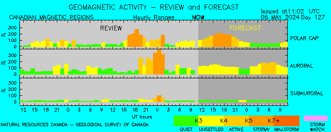
The two main factors on whether or not you can see aurora on any given night are the level of geomagnetic activity and where you are located. Of course weather and light pollution will also affect your ability to see aurora. More tips for viewing aurora can be found at the NOAA site.

Here are some forecasts that will help:

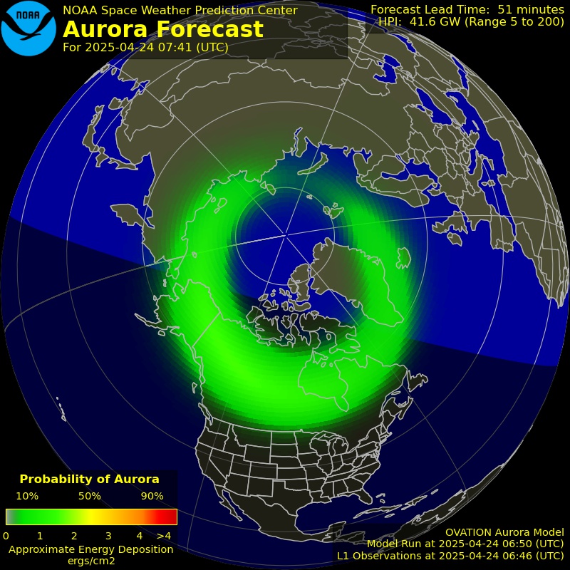
  • The OVATION Auroral Forecast from NOAA below shows probability of visible aurora at the current time. Be sure to reload if the image is not current. Day and night (dark) are indicated as well on the map to help you determine if the time is current.

Aurora Oval
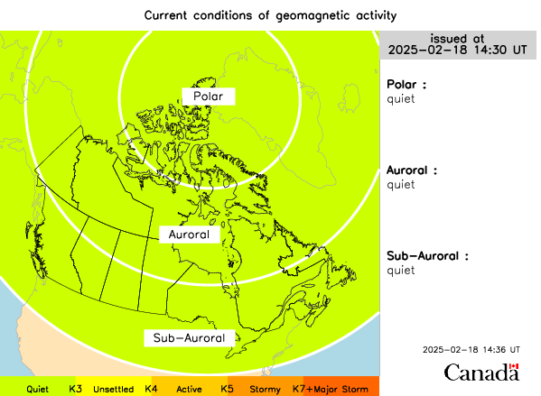
Current Conditions from Space Weather Canada

The Space Weather Gallery has some stunning photos and particularly these “Pinkest of all pinks (Aurora)” photos from Markus Varik in Norway. Pink auroras are rare and occur when particles reach lower levels of the Earth’s atmosphere. See spaceweather.com for further information.

We will update this page as new information becomes available.

Fireballs light up Ontario Skies in early December 2020

Three fireballs have been reported by Ontario residents during the past week including two last evening (Monday, December 7) and one during the day on Wednesday, December 2.

Conor M. shared this spectacular dash cam video of the 7:30pm fireball from last night.

The NASA Meteor Watch update of this fireball states that it occurred at 7:31 PM Eastern Standard Time. Over 150 reports were submitted from Ontario, Quebec and 12 states. Analysis of the video data from Western’s Southern Ontario Meteor Network showed the meteor was first visible above the town of Rossie, New York and disintegrated above Lyn, Ontario near Brockville. The estimated mass of the meteor was 3 kg and it had a diameter of 13 cm. The orbit that they calculated for this object suggests that it is from the Asteroid Belt between Mars and Jupiter and is not from the currently active Geminid meteor shower. The Geminid meteor shower, which peaks on December 13, is known to produce fireballs.

The “heat map” below is from the American Meteor Society event page and shows where people were located when they saw the meteor and its path (blue arrow) based on the observations.

Credit: American Meteor Society

Credit: American Meteor Society

For more information and videos of this fireball check out NASA’s fireball event page.

The second fireball occurred an hour later at about 8:30pm. This was not as widely reported and we do not have as much information about it. There are currently 28 reports from CT, DE, MD, NJ, NY, Ontario and PA. Here is the heat map from this event.

Credit: American Meteor Society

Credit: American Meteor Society

The fireball last week (December 2, 2020) was a rare daylight fireball that was not only spotted in Ontario and New York but also in 5 other states. The object was much larger than the ones from last night and is estimated to have had a mass of approximately 850-900 kg and had a diameter of 80-90 cm. This makes it close to being classified as an asteroid versus a meteoroid. When it broke apart the energy released was the equivalent of 66 tons of TNT.

Credit: American Meteor Society

Credit: American Meteor Society

A loud boom was reported as well around the time of this meteor. Sonic booms are associated with very bright meteors when they explode. The explosion that was produced by this bolide was also measured by seismic instruments in the area including one in Oshawa.

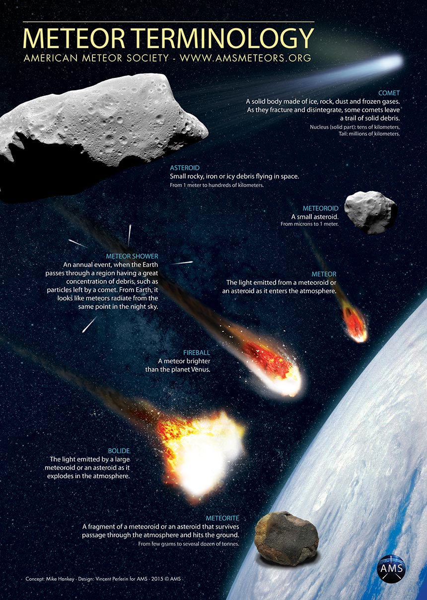
This poster from AMS explains the terminology of meteors.

If you see a fireball we encourage to you to report it to the either the American Meteor Society or the International Meteor Organization as your observations can help researchers.

Bus Cancellations & School Closures for Tuesday, December 1, 2020

Last Updated: 6:30am

**Please refresh your page every few minutes to receive the latest update**


Cancellation & Closure Map (English Public and Catholic Schools)

Please note: School board boundaries are a rough estimate. Don’t use this map to determine what school board or weather zone you live in as accuracy isn’t guaranteed.

Green = No Cancellations

Red = Cancellations (Click for More Details)

Purple = School Closures (Click for More Details)

Instant Weather Bus Cancellations and School Closures for December 2, 2020

List of Cancellations & Closures

English Public and Catholic Schools

  • Avon MaitIand Public & Huron-Perth CathoIic - There are many cancellations and school closures, please visit this link for more details:: https://geoquery.hpsts.ca/Alerts

  • BIuewater Public & Bruce-Grey Catholic - There are several cancellations, please visit this link for more details: https://www.mybrucegreyschoolbus.ca/Cancellations.aspx

  • Greater Essex Public & Windsor Essex CathoIic - Area A - City of Windsor - All Board Provided Transportation is Cancelled for the day. Area B - County of Essex - All Board Provided Transportation is Cancelled for the day.

  • Lambton Kent Public & St. CIair Catholic - Buses in Zones 1,2,3,4,5,6 & 7 cancelled today. Buses in Zone 8 running as normal and all schools open.

  • Near North Public & Nipissing-Parry Sound CathoIic - Bussing is cancelled in the following weather corridors:

    • Britt / Nobel, McDougall/Whitestone/Ahmic Harbour

    • Town of Parry Sound

    • Mactier, Humphrey, Rosseau

    • West Nipissing - including - River Valley/Field - Verner/Lavigne - Sturgeon Falls/Jocko Point

    • HWY 11 North- North of North Bay, Mattawa, North Bay, Callander, Bonfield, and East Ferris, Trout Lake/Four Mile Lake Rd, Redbridge /Thorne

    • East Parry Sound North - North of and including Hwy 522 - Port Loring/Restoule - Nipissing/Commanda - Powassan/Trout Creek

    • East Parry Sound South - South of Hwy 522 - South River/Sundridge - Burk’s Falls/Magnetawan - Katrine/Emsdale/Kearney/Sprucedale/Novar - Affects bussing for all Almaguin Highlands Secondary School

  • PeeI Public & Dufferin-PeeI Catholic - DPCDSB transportation in Dufferin County is cancelled today. Including RF Hall SS.

  • Renfrew County Public & Renfrew County Catholic - Transportation services in ZONE 4 ONLY (Madawaska) are CANCELLED for due to weather and road conditions. Transportation in all other weather zones is running and ALL SCHOOLS ARE OPEN.

  • Simcoe County Public & Simcoe Catholic - All school buses and vans in Simcoe County are cancelled today.

  • Thames Valley Public & London CathoIic - All school vehicles are CANCELLED for the day in Elgin, Oxford, Middlesex counties and Red Zone. City of London school vehicles will operate.

  • Tri-Board - Buses cancelled in North Hastings due to freezing rain.

  • Trillium LakeIands - All school vehicles to schools in Muskoka & Haliburton for Trillium Lakelands District School Board have been cancelled for  Tuesday December 1, 2020 due to current  road conditions and the forecast for continued snow throughout the day.

    All school vehicles to St. Dominic Catholic Secondary School, Monsignor Michael O’Leary and Saint Mary Catholic Elementary Schools have been cancelled.

    TLDSB schools are closed and remote learning will be offered to students within the two regions.

  • Upper Grand Public, Dufferin-PeeI Catholic & Wellington CathoIic - All School taxis and buses cancelled in Zones 2, 3, and 4 today. Zone 1 (Guelph) school vehicles are still running.

  • WaterIoo Public & WaterIoo Catholic - Due to the current weather conditions ALL SCHOOL BUSES, TAXIS AND SPECIAL EDUCATION ROUTES operated by the WCDSB and WRDSB are cancelled. All WCDSB and WRDSB schools and sites are CLOSED and it will be a Remote Learning Day.

French Schools

  • Conseil scolaire de district catholique Centre-Sud - There are cancellations and/or school closures. Visit this link for a complete list: https://www.cscmonavenir.ca/ecole/

  • Conseil scolaire Viamonde -

    • Region of Lambton: Transportation is cancelled today.

    • Region of Oxford: Transportation is cancelled today.

    • Region of Middlesex (rural routes): Transportation is cancelled today. Routes in the city of London are running.

    • Dufferin County : Transportation is cancelled today.

    • Region of Kitchener-Waterloo: Transportation is cancelled today.

    • Region of Simcoe: Transportation is cancelled today.

Bus Cancellations & School Closures for Monday, November 23, 2020

Last Updated: 6:45am

**Please refresh your page every few minutes to receive the latest update**


Cancellation & Closure Map (English Public and Catholic Schools)

Please note: School board boundaries are a rough estimate. Don’t use this map to determine what school board or weather zone you live in as accuracy isn’t guaranteed.

Green = No Cancellations

Red = Cancellations (Click for More Details)

Purple = School Closures (Click for More Details)

Instant Weather Bus Cancellations and School Closures for November 23, 2020

List of Cancellations & Closures

English Public and Catholic Schools

  • Renfrew County Public & Renfrew County Catholic - All transportation services are CANCELLED, for Monday November 23, 2020 due to Snowfall Warning. All schools are OPEN.

  • Tri-Board - Buses cancelled across Highway 7 and north this morning. Some buses in Stirling area as well. South is generally running this morning.

French Schools

  • Conseil des écoles publiques de l’Est de l’Ontario (CEPEO) - School transportation is canceled in Pembroke and Arnprior due to poor road conditions in these areas. Schools remain open. | Le transport scolaire est annulé à Pembroke et Arnprior en raison des mauvaises conditions routières dans ces secteurs. Les écoles demeurent ouvertes.

  • Conseil des écoles catholiques de langue française du Centre-Est - School transportation is canceled today for schools in Pembroke and Arnprior due to poor road conditions in these areas. | Le transport scolaire est annulé aujourd’hui pour les écoles à Pembroke ainsi que pour les élèves qui demeurent à Arnprior dû aux mauvaises conditions routières dans ces secteurs.

42ND TORNADO OF THE YEAR CONFIRMED From Nov 15 Windstorm Adds to the Already Record Breaking Tornado Season!

NTP event map (blue EF0, green EF1)

NTP event map (blue EF0, green EF1)

The Northern Tornadoes Project (NTP) has confirmed an EF1 Tornado from the wind storm on November 15, 2020 in Georgetown, Ontario. In an already record breaking year, this is also one of the latest tornadoes that Ontario has experienced. The previous record for the most confirmed tornadoes in a year was set in 2009 with 37 tornadoes.

The Investigation map, drone and ground photos from NTP can be found here.

NTP also investigated and confirmed 4 downbursts at New Dundee (EF0), Port Burwell (EF0), Dunnville (EF0) and Ingersoll (EF1).

See the table below for details on the tornado and downbursts (from the NTP dashboard). Note how large the track lengths and path widths are for the downbursts. Tip: view the table in landscape mode on phones.

<

At 2:24pm, 21 minutes before the tornado touched down in Georgetown, we posted "Embedded, brief tornadoes are not entirely out of the question today with the strongest storms." This was included in a post about a potential tornado report in Port Burwell, which was later confirmed to be an EF0 downburst:

We also issued forecasts for this significant wind storm and here was the final forecast:

During the wind storm we also provided many updates to keep everyone informed:

Many people experienced power outages from the storm and Hydro One crews had to restore power to 370,000 customers in the most significant storm for Hydro One since May 2018.

Environment Canada issued a weather summary below for the event. They measured both thunderstorm wind gusts and non-thunderstorm wind gusts.

Weather summary
for Ontario and the National Capital Region
issued by Environment Canada
at 6:33 a.m. EST Monday 16 November 2020.

Discussion.

A powerful Fall Storm tracked through Ontario Sunday and Sunday 
night, bringing widespread destructive winds and severe 
thunderstorms to southern Ontario and strong winds and wintry 
weather to northern Ontario. 

The following is a summary of weather event information received by 
the Ontario Storm Prediction Centre. 

1. Summary of official thunderstorm wind gusts in kilometres per 
hour: 

Niagara District Airport: 141 
Port Colborne: 131 
Brampton-Caledon Airport: 120 
Windsor Airport: 111 
Baden Hill: 105 
Region of Waterloo Airport: 104 
Erieau: 102 
Hamilton Munro Airport: 102 
Point Petre: 102 
Toronto Pearson Airport: 100 
Chatham-Kent Airport: 100 
Toronto Billy Bishop Airport: 98 
Elora: 98 
Vineland: 98 
Muskoka Airport: 96 
Mono Centre: 94 
Western Islands: 91 
Ridgetown: 91 
Sarnia Chris Hadfield Airport: 89 
Egbert: 89 
London Airport: 85 
Harrow: 83 
Mount Forest: 81 
Peterborough Trent U: 81 
Cobourg: 81 
King City: 80 

Widespread damage from these thunderstorms has been reported across 
southwestern and south-central Ontario, including snapped utility 
poles, downed trees, and roof damage. 

2. Summary of official non-thunderstorm wind gusts in kilometres per 
hour: 

Port Colborne: 131 
Baden Hill: 122 
Toronto Billy Bishop Airport: 119 
Region of Waterloo Airport: 117 
Western Islands: 115 
Point Petre: 107 
Chatham-Kent Airport: 98 
Cobourg: 96 
Wiarton Airport: 93 
Windsor Airport: 91 
Erieau: 91 
Lagoon City: 91 
Toronto Pearson Airport: 91 
Mono Centre: 91 
CFB Trenton: 89 
Kingston: 89 
Goderich: 87 
London Airport: 87 
Killarney: 87 
Brantford Airport: 85 
Gore Bay-Manitoulin Airport: 85 
Oshawa AIrport: 85 
Welland: 83 
Vineland: 83 
Tobermory: 83 
CFB Borden: 83 
Harrow: 83 
Ridgetown: 83 
Muskoka Airport: 81 
Great Duck Island: 81 
Elora: 80 
Niagara District Airport: 80 
Sault Ste. Marie Airport: 80 

Widespread damage from this synoptic wind has been reported across 
southwestern and south-central Ontario, including snapped utility 
poles and downed trees. Between the thunderstorms and synoptic 
winds, well over 200 000 customers lost power on Sunday across the 
province. 

3. Summary of rainfall in millimetres: 

Shaw Dam Lake*: 57.7 
Massey*: 40.4 
Quirke Lake*: 40.3 

*denotes data from Ontario Ministry of Natural Resources and 
Forestry

Please note that this summary may contain preliminary or unofficial 
information and does not constitute a complete or final report.

End/OSPC

The high wind gusts in Port Colborne are likely responsible for this wayward shed.

Thank you to all those who have reported what they experienced during storms as your reports make all the difference when it comes to confirming tornadoes, downbursts, and any severe weather in our region.

Alberta: 2020 Summary of Tornadoes and Other Investigated Events

NTP summary of events

NTP summary of events

Below is a summary of the events in Alberta that were investigated by the Northern Tornadoes Project as of December 16, 2020. There are 11 confirmed tornadoes, 6 downbursts, and 1 unclassified wind damage event. There were also 27 non-tornadic events that were investigated. Links to the summaries for the other provinces can be found here.

Below is a map from the NTP Dashboard showing the location of the tornadoes.

Tornadoes

Tornadoes

Below is a map from the NTP Dashboard showing the location of the downbursts and unclassified wind event.

Downbursts

Downbursts

The details of the events are listed below and the comments are taken directly from the NTP Interactive Dashboard. Tip for viewing the table on a phone - try turning your phone so that you are in landscape mode.

Our thoughts are with all those affected by severe storms this year.

2020 Provincial Summaries

More provinces will be added once their summaries are completed.

British Columbia: 2020 Summary of Tornadoes and Other Investigated Events

NTP summary

NTP summary

Below is a summary of the events in British Columbia that were investigated by the Northern Tornadoes Project as of November 2 2020. There are 2 confirmed tornadoes and 1 downburst. They also investigated 5 other events that they classified as non-tornadic vortices. Links to the summaries for the other provinces can be found here.

The details of the events are listed below and the comments are taken directly from the NTP Interactive Dashboard. Tip for viewing the table on a phone - try turning your phone so that you are in landscape mode.

Tornadoes are rare in British Columbia. There were no confirmed tornadoes in 2019. One EF0 tornado occurred on September 16 2018 in Mission.

Our thoughts are with all those affected by severe storms this year.

2020 Provincial Summaries

More provinces will be added once their summaries are completed.

The Full Moon on Halloween is a Special One

Credit: NASA/JPL-Caltech

Credit: NASA/JPL-Caltech

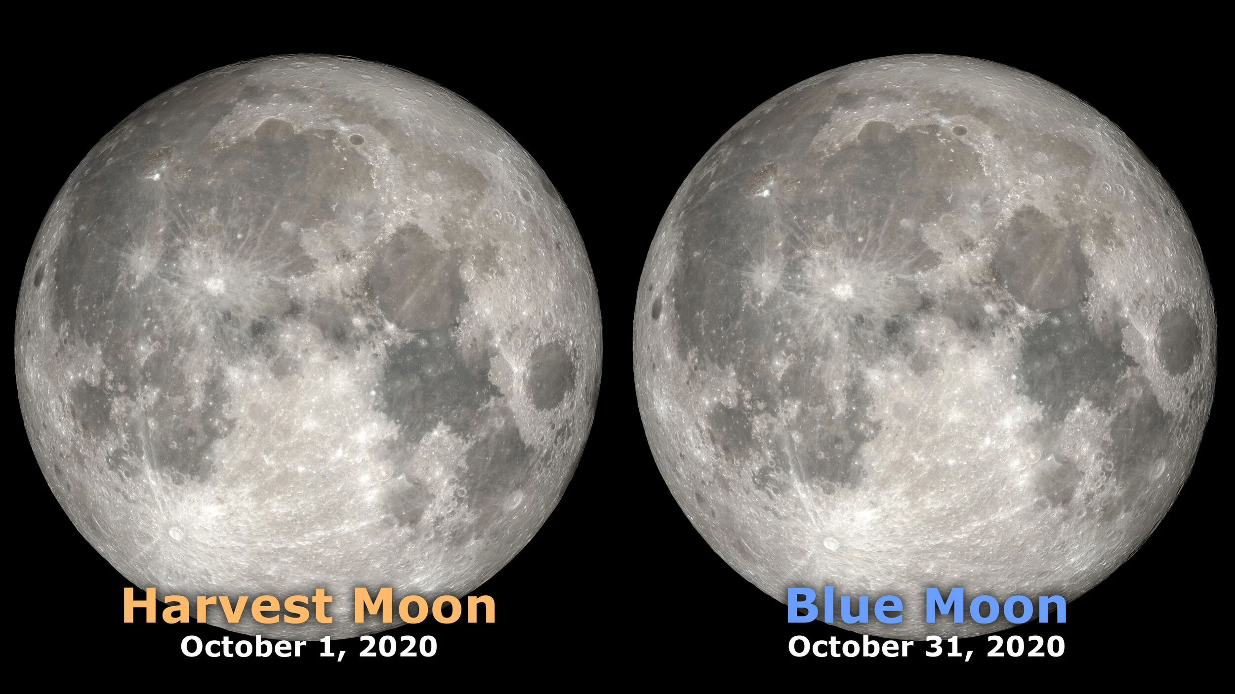
This year's full moon on Halloween has many names - blue moon, micromoon, Hunter's Moon, and the Beaver Moon are just a few. See this article from NASA for a discussion of the many names of Saturday's full moon.

Is this Halloween’s full moon a blue moon?

A common definition of a blue moon is the second full moon during the same calendar month. This means that all full moons on Halloween will also be a blue moon. Full moons occur every 29.5 days which is less than the number of day in October. So the answer is yes by this definition. NASA’s Scientific Visualization Studio created the image below.

CREDIT NASA's Scientific Visualization Studio

CREDIT NASA's Scientific Visualization Studio

Another traditional definition of a blue moon is that it is the third full moon in a season where there are 4 full moons. Normally a season has 3 full moons since it is 3 months long. The seasonal or traditional definition of a blue moon is independent of where you live and what time zone you are unlike the calendar definition. See https://en.wikipedia.org/wiki/Blue_moon#Blue_moons_between_2009_and_2037 for a list of seasonal and calendar blue moons between 2009 and 2037. The full moon on Saturday is not a seasonal blue moon.

What is a micromoon?

Saturday's full moon is also a micromoon. A micromoon is when the moon is at its furthest point in its orbit from the earth during its full or new phase. The orbit of the moon is elliptical and the distance from the earth to the moon varies quite a bit. It can be as close as 356,500 km at perigee (average is 363,300 km) or as far as 406,700 km at apogee (average is 405,500 km). On Oct 30 the moon is 406,394 km away. There is a significant difference in the size and brightness of a supermoon and micromoon. A supermoon is 14% bigger and 30% brighter than a micromoon.

Ever wondered why the Moon looks bigger and brighter during a supermoon? Watch this short animation to find out. Learn more about supermoons, here: www.jpl.n...

CREDIT: NASAJPL Edu

Educators and astronomy enthusiasts: JPL has an activity on how you could measure this difference over many months.


On average we will see a full moon on Halloween every 19 years. The next one will occur in 2039. If the sky is clear be sure to check out the full moon on Halloween as it is a special event that won’t happen again for quite a while.

BREAKING: Friday’s Storm Produced at Least One Confirmed EF0 Tornado With 130km/h Estimated Wind Gusts

Map20201023-Confirmed.jpg

The Northern Tornadoes Project (NTP) and Environment & Climate Change Canada (ECCC) have confirmed an EF0 Tornado from Friday's storm in Thornbury, Ontario with estimated wind speeds of 130km/h.

INCREDIBLE Video of What Appears to Be a Tornado From Thornbury, Ontario During Friday's Storm: Video of what appears to be a tornado, filmed by Kim H.G. fro...

Our thoughts remain with those affected by Friday's storms and thankfully we haven't heard of any injuries, especially considering this incredible story from Mike Holder on Facebook (click the link to learn more):

Significant damage and incredible story from the Thornbury Harbour during Friday’s likely tornado (still under investigation). So glad you stayed safe, Mike! 😬 - Adam

Posted by Instant Weather Ontario on Sunday, October 25, 2020

Here's what Environment Canada wrote:

"Weather summary for Ontario and the National Capital Region issued by Environment Canada at 10:10 a.m. EDT Monday 26 October 2020.

Discussion.

A tornado has been confirmed by the Northern Tornadoes Project in Thornbury on October 23rd. The following is a summary of weather event information received by Environment Canada as of 9:00 A.M. EDT on Monday, October 26th, 2020.

Event Location:

Thornbury.

Event Description:

A tornado struck the area on the afternoon of Friday, October 23rd, 2020. The tornado followed a path through the town before entering Georgian Bay. The tornado has been given a preliminary rating of EF0 on the Enhanced Fujita scale with estimated maximum wind speeds up to 130 km/h and a path length of 3 kilometers. The tornado produced tree damage and damage to a power pole and street lamp.

This tornado accompanied several severe thunderstorms which affected areas near and east Georgian Bay on Friday afternoon with numerous reports of large hail up to the size of golf balls and strong winds. Meteorologists at the Ontario Storm Prediction Centre would like to thank the Northern Tornadoes Project for their continued work on analyzing and documenting tornadoes.

Please note that this summary may contain preliminary or unofficial
information and does not constitute a complete or final report.

End/OSPC"

We certainly agree with ECCC regarding the great work the NTP is doing and a huge shoutout to Dr. Sills, Dr. Kopp, and all those involved with the project!

Also, a huge thank you to Kim H.G. for the incredible video that clearly demonstrates the rotating wall cloud above the spray ring and the trailing rear-inflow jet or “ghost train”. Not to mention the howl in the video is very creepy and that classic "train in the distance" tornado sound that so many report.

Here's what the NTP tweeted:

And last but not least, here is the forecast map and forecast for Friday that was issued roughly twenty-four hours before the tornado touched down.

Thunderstorm_SON_Friday.jpg

Thank you to all those who have reported what they experienced during these storms as your reports make all the difference when it comes to confirming tornadoes, downbursts, and any severe weather in our region.

BREAKING: 39 Confirmed Tornadoes Breaks the All Time Ontario Record of 37 in One Season

Using hi-resolution satellite images, the Northern Tornadoes Project (NTP) has confirmed 5 more tornadoes in Ontario. This brings the total for 2020 up to 39 as of October 19th and breaks the record of 37 set in 2009.

As well, there are now 10 tornadoes that have been confirmed to have occurred during the tornado outbreak on June 10th.

NTP map of the June 10 Tornado Outbreak

NTP map of the June 10 Tornado Outbreak

The path of the EF2 tornado on July 13 at Stout Lake is clearly visible in the tweet by NTP below. This illustrates how satellite images can be used to investigate tornadoes.

NTP has completed their investigations of 101 events in Ontario with an additional 7 events currently under investigation. NTP determined that 39 of these events were tornadoes, 39 were classified as downbursts, 12 were non-tornadic vortices, 5 were waterspouts, and 6 were unclassified wind damage events (i.e. there was not enough evidence to determine the cause of the damage). We will share more details about these events as they become available.

A huge thank you those who have reported tornadoes and wind damage over the years as your reports significantly contribute to the NTP’s ability to confirm a large portion of the tornadoes in Ontario this season.

In the video below, Dr. David Sills, Executive Director of the NTP discusses Instant Weather and the benefit our communities provide to the NTP with their investigation of tornadoes across Canada:

We are truly humbled by the flattering comments of Dr. Sills and our thoughts are with those affected by these dangerous storms.

Saskatchewan: 2020 Summary of Tornadoes and Other Investigated Events

NTP summary of events

NTP summary of events

Below is a summary of the events in Saskatchewan that were investigated by the Northern Tornadoes Project as of December 16, 2020. There are 7 confirmed tornadoes, 10 downbursts, and 1 unclassified wind damage event. Links to the summaries for the other provinces can be found here.

Below is a map from the NTP Dashboard showing the location of the tornadoes.

Tornadoes

Tornadoes

Below is a map from the NTP Dashboard showing the location of the downbursts.

Downbursts

Downbursts

The details of the events are listed below and the comments are taken directly from the NTP Interactive Dashboard. Tip for viewing the table on a phone - try turning your phone so that you are in landscape mode.

Our thoughts are with all those affected by severe storms this year.

2020 Provincial Summaries

More provinces will be added once their summaries are completed.

Manitoba: 2020 Summary of Tornadoes and Other Investigated Events

NTP map of events

NTP map of events

Below is a summary of the events in Manitoba that were investigated by the Northern Tornadoes Project as of December 16, 2020. There are 7 confirmed tornadoes, 5 downbursts, and 4 unclassified wind damage events. Links to the summaries for the other provinces can be found here.

The details of the events are listed below and the comments are taken directly from the NTP Interactive Dashboard. Ground and drone survey photos of the Scarth EF3 tornado can be found here. Tip for viewing the table on a phone - try turning your phone so that you are in landscape mode.

Our thoughts are with all those affected by severe storms this year and our condolences remain with the families and friends of the two 18-year-olds who were tragically killed during the Scarth EF3 tornado.

2020 Provincial Summaries

More provinces will be added once their summaries are completed.

Be on the Alert for Aurora Sunday and Monday Nights

aurora_borealis_northern_lights_sky_night_landscape_nature_dark_colorful-1058133.jpg

The NOAA Space Weather Prediction Center has issued a watch for a Geomagnetic Storm Category G2. This means that places as far south as New York could see aurora on Sunday and Monday nights. Excerpt from the alert issued on 2020 Sep 27 2045 UTC:

Highest Storm Level Predicted by Day:
Sep 28:  G2 (Moderate)   Sep 29:  G2 (Moderate)   Sep 30:  G1 (Minor)

THIS SUPERSEDES ANY/ALL PRIOR WATCHES IN EFFECT

NOAA Space Weather Scale descriptions can be found at
www.swpc.noaa.gov/noaa-scales-explanation

Potential Impacts: Area of impact primarily poleward of 55 degrees Geomagnetic Latitude.
Induced Currents - Power grid fluctuations can occur. High-latitude power systems may experience voltage alarms.
Spacecraft - Satellite orientation irregularities may occur; increased drag on low Earth-orbit satellites is possible.
Radio - HF (high frequency) radio propagation can fade at higher latitudes.
Aurora - Aurora may be seen as low as New York to Wisconsin to Washington state.

UPDATE: The latest watch as of

Issue Time: 2020 Sep 29 1556 UTC

WATCH: Geomagnetic Storm Category G1 Predicted

Highest Storm Level Predicted by Day:
Sep 29:  G1 (Minor)   Sep 30:  G1 (Minor)   Oct 01:  None (Below G1)

THIS SUPERSEDES ANY/ALL PRIOR WATCHES IN EFFECT

Comment: Decreasing max threshold potential from G2 to G1 to be consistent with activity as the storm progresses and wanes

NOAA Space Weather Scale descriptions can be found at
www.swpc.noaa.gov/noaa-scales-explanation

Potential Impacts: Area of impact primarily poleward of 60 degrees Geomagnetic Latitude.
Induced Currents - Weak power grid fluctuations can occur.
Spacecraft - Minor impact on satellite operations possible.
Aurora - Aurora may be visible at high latitudes, i.e., northern tier of the U.S. such as northern Michigan and Maine.

The two main factors on whether or not you can see aurora on any given night are the level of geomagnetic activity and where you are located. Of course weather and light pollution will also affect your ability to see aurora. More tips for viewing aurora can be found at the NOAA site.

Here are some forecasts that will help:

  • The OVATION Auroral Forecast from NOAA below shows probability of visible aurora at the current time. Be sure to reload if the image is not current. Day and night (dark) are indicated as well on the map to help you determine if the time is current.

Aurora Oval
Current Conditions from Space Weather Canada

The Space Weather Gallery has some stunning photos and particularly these “Pinkest of all pinks (Aurora)” photos from Markus Varik in Norway. Pink auroras are rare and occur when particles reach lower levels of the Earth’s atmosphere. See spaceweather.com for further information.

We will update this page as new information becomes available.

Ontario's 33rd Tornado Confirmed in Pembroke on Sunday, Sept. 13th

The Northern Tornadoes Project Team has assessed the storm damage from last Sunday afternoon in Pembroke and has determined it was caused by a tornado. This tornado has been preliminarily rated as an EF0 tornado with a maximum wind speed of 125km/h.

With this latest confirmation, it brings the tornado count for Ontario up to 33 in what has been a very active tornado season. For comparison, Ontario normally sees 13 tornadoes in an average year so we are well above average this year.

There was substantial wind damage around the Drive In Road area reported after the storm:

Hearing of substantial wind damage in Pembroke. Please let us know if have any further reports and we hope everyone...

Posted by Ontario Tornado Watch / Ontario Blizzard Watch on Sunday, September 13, 2020

The investigation continues and further information could be released which may change the rating or max wind speed. We will have a more in-depth analysis once we get more details. Stay tuned!

Is This a True Fire Tornado?

This video was posted recently to TikTok and is from one of the areas that is being devastated by wildfires on the west coast of the United States. (When we have more information we will update this article.)

Chad (@flamecatcher2) has created a short video on TikTok with music Tornado Siren Sound Effect. | #wildfire #wildlandfirefighter #2020

Is this a true fire tornado?

In order to answer this question we first must understand what a true fire tornado is. Often people call a fire whirl a fire tornado or firenado but just as a dust devil is not a tornado, similarly, fire whirls are not true tornadoes.

Fire whirls are whirlwinds caused by a fire and are usually small in size. Though some can be similar to a landspout tornado, a rope like funnel that forms from a thunderstorm that has no rotating updraft. Landspout tornadoes can be dangerous and the damage caused tends to be EF2 or lower on the Enhanced Fujita scale.

A prerequisite to a true fire tornado is a pyrocumulonimbus cloud which is a Cumulonimbus (Cb) cloud that forms above a heat source like a wildfire but could also form above a volcanic eruption. Supercell thunderstorms which sometimes produce tornadoes also have cumulonimbus clouds. A supercell has a mesocyclone, a deep persistent rotating updraft. This rotation is what can sometimes result in a tornado.

This excellent video explains the proof that the Australian researchers had that a true fire tornado was responsible for the catastrophic destruction during the Canberran bushfires in 2003.

Australian researchers now have proof that a devastating fire tornado carved a path of destruction during the Canberran bushfires in 2003. Subscribe to ABC S...

This is the first documented true fire tornado.

The Fire tornado video taken by Tom Bates has a time stamped description of the features of the tornado. The estimated wind speeds in excess of 250km/hr resulted in it being classified as an EF3 tornado.

On July 18 2018, a second true fire tornado was documented in Redding, California. The Carr Fire spawned an EF3 fire tornado. This is also the strongest tornado recorded to date in California.

Another possible fire tornado occurred recently (December 30 2019) in Australia and sadly resulted in the death of a volunteer firefighter when his truck was flipped over.

For the first time the National Weather Service issued a tornado warning due to a fire on August 15 2020. The NWS saw rotation on radar associated with the pyrocumulonimbus cloud from the Loyalton Wildfire in Southeastern Lassen County in northern California and they issued this tornado warning:

Fire Tornado Warning from NWS

Fire Tornado Warning from NWS

They also issued the following related tweets:

Tweets from NWS Reno

Tweets from NWS Reno

Any tornado is dangerous just as any wildfire is dangerous but a fire tornado is even more dangerous especially to firefighters battling the fire.

To our knowledge (at the time of publishing this article) there was no similar tornado warning issued recently. Even if there wasn’t a tornado warning or a tornadic pyrocumulonimbus cloud associated with this fire vortex, this is more significant event than a small fire whirl. There is not enough information at this time to answer the question of whether or not the TikTok video is showing a true fire tornado.

The wildfires that are occurring in the United States are devastating. Our thoughts are with all those that are affected.

References and further reading:

https://en.wikipedia.org/wiki/Enhanced_Fujita_scale

https://www.nssl.noaa.gov/education/svrwx101/tornadoes/types/

https://esa.act.gov.au/cbr-be-emergency-ready/bushfires/fire-tornado-video

https://www.sciencenewsforstudents.org/article/californias-carr-fire-spawned-true-fire-tornado

https://www.youtube.com/watch?v=rqYEeivt8Eg

https://www.abc.net.au/news/2019-12-31/rfs-volunteer-firefighter-dies-in-truck-rollover/11833634

Ontario’s Tornado Count Is Now Up to 32 for the Year; 2 Tornadoes on September 3 2020 Confirmed

Confirmed-tornadoes.jpg

The Northern Tornado Project (NTP) team investigated storm damage that occurred on the evening of September 3, 2020 at both Port Colborne and Washago. The preliminary results of their investigation is that there was a high end EF0 tornado in Port Colborne and a EF1 tornado in Washago. There have been five tornadoes that have been recenlty confirmed.

This brings the total number to 32 and we could potentially see more tornadoes in Ontario this year. NTP has only recently started investigating and confirming tornadoes in Ontario (see here for more information about the project, which was founded in 2017). NTP confirmed 23 tornadoes in 2018 and 13 tornadoes in 2019 in Ontario. Compare these numbers with the Ontario government’s average of 12. The average is expected to increase as tornado detection improves and we get a more complete picture of how often tornadoes occur.

This article focuses on the two tornadoes that occured on September 3. For information about the other recently confirmed tornadoes please see:

August 27, 2020 - EF1 at Mount Carmel and EF1 at Union

August 28, 2020 - EF0 at Point Clark

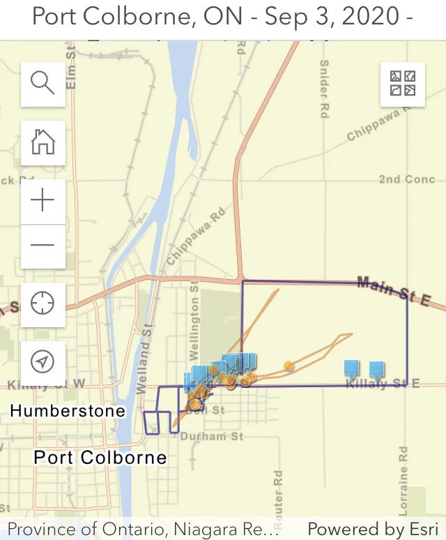
Port Colborne’s EF0 tornado (late evening) had a maximum wind speed 125 km/h, a path length of 1.1 km, and a maximum width of only 50 m. The tornado produced damage to some trees and houses.

The investigation map from NTP below shows the drone (orange) and the land (blue) survey paths. Click on the map to go to their site and view the photos.

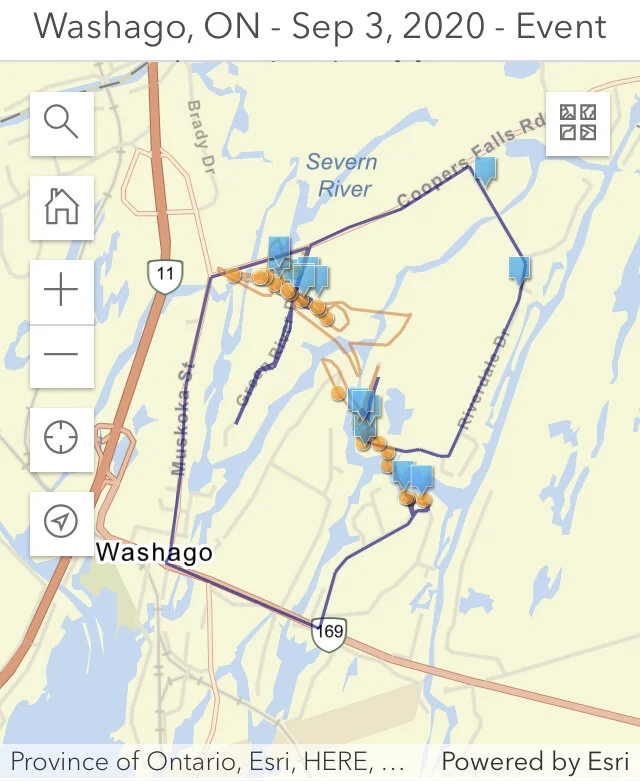
Washago’s EF1 tornado (evening) had maximum wind speed of 145 km/h, a path length of 1.85 km and a maximum width of 90 m. The tornado produced damage mainly to mature trees along a narrow path.

You can see the narrow path of the tornado in this video:

The investigation map from NTP below shows the drone (orange) and the land (blue) survey paths. Click on the map to go to their site and view the photos.


We sincerely hope everyone stayed safe in the path of these tornadoes and thank you so much to all of those who sent in reports! Your reports are critical in confirming tornadoes and continuing our goal to raise awareness about them and severe weather. Thank you!

Two More Tornadoes in Ontario; 2 EF1 Tornadoes on August 27 2020 Confirmed

The Northern Tornado Project team confirmed that two EF1 tornadoes occurred during the afternoon of August 27, 2020 in Southern Ontario.

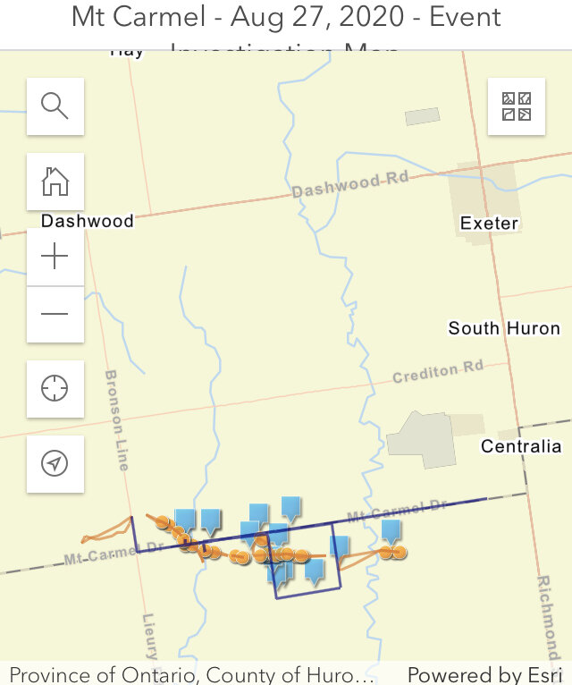
Their investigation of the tornado at Mount Carmel (2:30 PM) found that this tornado had a maximum wind speed of 155 km/h, 7.1 km long path with a width of 100m. The damage to the century barn can be seen in this tweet by Connell Miller from NTP:

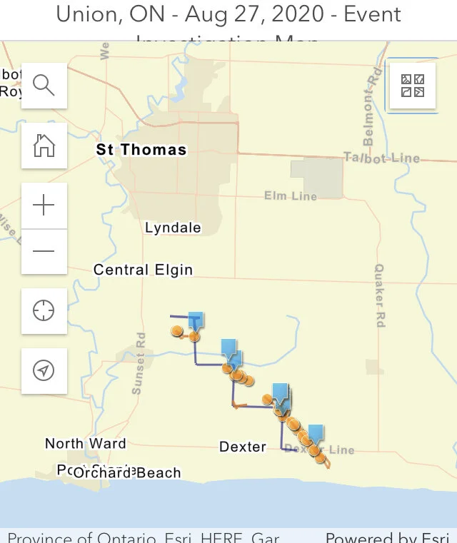
A second tornado at Union (St. Thomas area) which occurred at 3:15 PM had a maximum wind speed of 150 km/h, 5.2 km long path with a width of 150m. They found that a small century barn was shifted on its foundation as well as damage to trees and crops. If you look closely you can also see crop damage in second photo in the tweet below:

NTP has information about their investigations including photos and maps showing the land (blue) and drone (orange) survey paths and where the photos were taken. Click on the maps below to go to their site and view the details.


Timeline

11:30 AM: Environment Canada issued a Severe Thunderstorm Watch that included both areas affected by the tornadoes:


1:29 PM: Environment Canada issued a Severe Thunderstorm Warning that includes Southern Huron County (Mount Carmel):


2:06 PM: Environment Canada issued a Severe Thunderstorm Warning for an area that included Eastern Lambton County (just south of Mount Carmel)


2:39 PM: Environment Canada issued a Severe Thunderstorm warning for the area that included St. Thomas (Union):


2:45 PM: Adam went live.


3:12 PM: We notified all those in the path who use our app, text service, and social media pages “Tornado Reported” for the area near St. Thomas (Union).


3:12 PM: At the same time Environment Canada also issued a Tornado Warning for the St Thomas (Union) area:


Keep alert and trust your intuition if you think that the weather may be severe. The Mount Carmel tornado did not have a tornado warning. There can be many reasons why some tornadoes are not warned. Different areas have different radar coverage and some tornadoes do not have a strong radar signature. Some tornadoes may also form quickly and the associated radar signature is brief. Observations by reliable spotters play a role in tornado warnings as well.

We sincerely hope everyone stayed safe in the path of these tornadoes and thank you so much to all of those who sent in reports! Your reports are critical in confirming tornadoes and continuing our goal to raise awareness about them and severe weather. Thank you!

Embed Block
Add an embed URL or code. Learn more

Ontario's 29th Tornado Of The Year; EF0 Tornado Confirmed From Friday At Point Clark, ON With 130km/h Maximum Estimated Winds

(Radar Image courtesy of enVironment canada)

(Radar Image courtesy of enVironment canada)

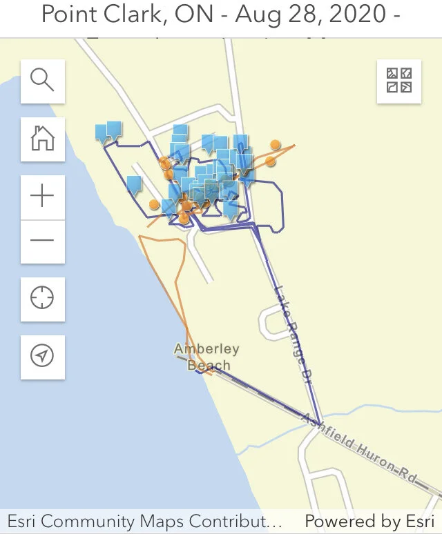
The Northern Tornado Project team has found damage consistent with a high-end EF0 tornado in Point Clark, Ontario. This tornado occurred at approximately 10:15 PM on Friday, August 28, 2020.  It adds to Ontario’s already very active tornado season being the 28th tornado in 2020 - more than double the average of 13! The estimated maximum wind speed was 130 km/h. They also found the path of the tornado to be 300 metres long with a maximum width of 80 metres. Note, the multiple directions that the trees fell which is a good indicator of a tornado:

You can also see the tree damage with the drone footage by Connell Miller:

Environment Canada also tweeted out this image showing radar images of the storm:

Mike Nailor shared some close up photos of the tree damage in the area:

The township sent out this news release the next day stating that significant damage had occurred:

The investigation map from NTP below shows the drone (orange) and the land (blue) survey paths. Click on the map to go to their site and view the photos.


Timeline

3:30 PM: We posted a heads up forecast that an isolated tornado was possible in the evening:

3:30 PM - Fri, Aug 28, 2020: Good afternoon! Keeping an eye on the potential for more strong thunderstorms later this...

Posted by Ontario Tornado Watch / Ontario Blizzard Watch on Friday, August 28, 2020

9:28 PM: Environment Canada issued a Severe Thunderstorm Watch:


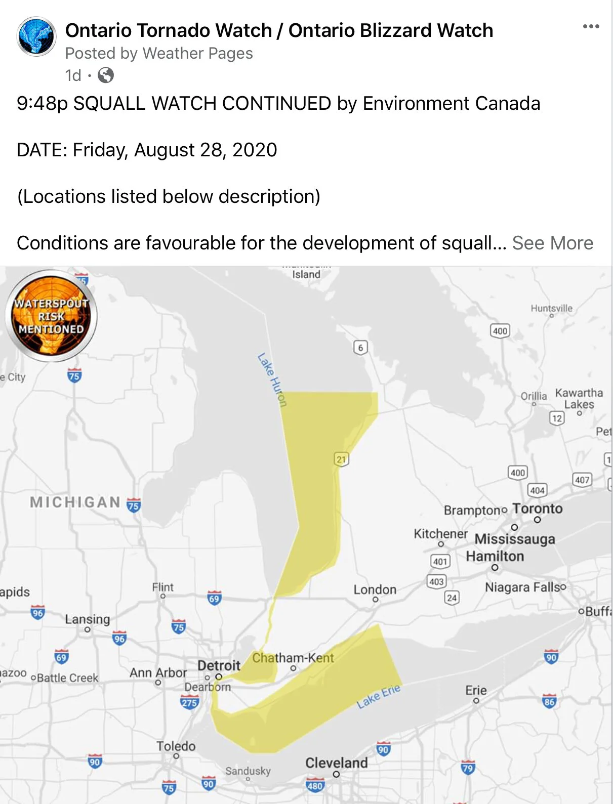
9:48 PM: Environment Canada issued a Squall Watch for Lake Huron mentioning waterspout potential.


9:51 PM: Environment Canada issued a Severe Thunderstorm Warning:


9:58 PM: With the help of Kevin Ramage, we notified all those in the path who use our app, text service, and social media pages “Minor Rotation Detected” and the potential of an isolated tornado:


10:05 PM: Environment Canada issued a Squall Warning for Lake Huron mentioning waterspout potential:


10:12 PM: Environment Canada upgraded the Severe Thunderstorm Warning to mention the potential of a tornado.


We sincerely hope everyone stayed safe in the path of this tornado and thank you so much to all of those who sent in reports! Your reports are critical in confirming tornadoes and continuing our goal to raise awareness about them and severe weather. Thank you!