Strong Severe Thunderstorm Risk for Parts of Saskatchewan & Manitoba on Friday

NOTE: YOU CAN CLICK ON THE MAP TO OPEN A ZOOMABLE IMAGE


The Victoria Day long weekend is poised to start on a stormy note in parts of Saskatchewan and Manitoba due to a potential severe thunderstorm risk on Friday.

Warm air is expected to surge into Southeastern Saskatchewan and Southwestern Manitoba during the day on Friday, with temperatures soaring into the mid to upper 20s. This heat will act as the perfect catalyst for thunderstorm activity, which is likely to begin as early as Friday afternoon.


live storm coverage

We will be going live to provide in-depth severe weather coverage later this afternoon. Please download our app to be notified when we go live or click the button below to view our YouTube live stream later today.


GOOGLE AD (NOT ENDORSED BY INSTANT WEATHER)

The initial storm activity is expected to start in Southeastern Saskatchewan along the border with Manitoba around 1 to 3 PM. Additional storm development may occur south of the border over North Dakota before tracking into Saskatchewan and Southwestern Manitoba by late afternoon.

Further north, some isolated storms may also develop around Melville and Kamsack before moving into the Roblin and Dauphin areas in Manitoba by late afternoon or early evening.

There are indications that the environment in this area will be quite favourable for the development of supercells that could produce extremely large hail, up to the size of golf balls or larger.

Damaging wind gusts are also a possibility, although the wind threat seems to be less of a concern compared to the hail risk. One or two tornadoes are also possible as these storms track towards the Interlake region.


GOOGLE AD (NOT ENDORSED BY INSTANT WEATHER)

The storms to the southwest are expected to merge with those isolated storms around the Dauphin region and form one main line stretching from Ashern to Winkler by early evening. By this point, the complex of storms will mostly pose a marginal to slight severe wind and hail risk. The tornado threat will be lower compared to earlier in the day, but a brief spin-up cannot be completely ruled out.

The storm system will continue to move east towards the Ontario border, reaching Winnipeg between 9 and 11 PM and crossing over into Ontario just after midnight.

For Winnipeg, it's uncertain how strong the storm will be by the time it reaches the city since it will occur well after sunset and the line of storms will be gradually weakening. The most probable storm threats include hail up to the size of quarters, wind gusts up to 90 km/h, and heavy rain along with lots of lightning.

Another Wet Start to the Week As a Storm Brings Up to 75mm of Rain to Southern Alberta

NOTE: YOU CAN CLICK ON THE MAP TO OPEN A ZOOMABLE IMAGE


Great news! More moisture is on the way for Southern and Central Alberta and this time it will impact the southeast the most. After last week’s snow failed to spread too far east of Calgary, those that missed out on the precipitation will have their turn with heavy rain expected to begin in the late afternoon Monday and continue into Wednesday.


GOOGLE AD (NOT ENDORSED BY INSTANT WEATHER)

A strong low pressure system is making its way into the province from the south and we will start to see some light rain pushing northward late Monday afternoon, reaching the Edmonton area by the mid-evening hours. The rain is then expected to intensify overnight and moderate rain will continue throughout the day Tuesday. Rainfall rates exceeding 2mm/hr will last for several hours, which will drive up totals in the hardest hit areas, particularly around Brooks, Taber, and Medicine Hat where up to 75mm is expected to fall from this system. The rain will then start to taper off Wednesday morning, but light rain is expected to continue until the evening. This amount of rain in a short period of time will likely lead to localized flooding so be prepared, especially when travelling in this region.

 Meanwhile, Calgary and southward along the Highway 2 corridor, along with to the northwest, including Rocky Mountain House and Drayton Valley, can expect to see rainfall amounts of 10-20mm and even less than that moving westward. Those in the Rockies may see a bit of drizzle, but precipitation from this system will fall mostly as snow, with 10-20cm expected through the region.


GOOGLE AD (NOT ENDORSED BY INSTANT WEATHER)

Conditions will also be a bit windy across Southern and Central Alberta throughout the duration of this event. Widespread gusts of 50-70km/h with pockets up to 90km/h are expected to peak late Tuesday morning and into the evening and the winds completely die off by late Wednesday with the end of the storm.

 Thankfully the heaviest rain is coming to the driest part of Southern Alberta, and it should really help decrease the wildfire risk in the area.

A Late April Storm Will Bring Much Needed Moisture to Parts of Southern Alberta in the Form of Heavy Wet Snow

NOTE: YOU CAN CLICK ON THE MAP TO OPEN A ZOOMABLE IMAGE


As the month of April comes to an end along with the start of the wildfire season, we’re happy to share that there is some moisture on the way for parts of Southern Alberta to start this week. Unfortunately for those who are looking forward to the summer months, this moisture is predominately coming in the form of wet snow.


GOOGLE AD (NOT ENDORSED BY INSTANT WEATHER)

The first round of snow moves into the province Monday evening and continues into Tuesday morning. The Southern Rockies will see the bulk of this snowfall and can expect 10-20cm by mid-day Tuesday. To the east, including Red Deer and Calgary, a rain and snow mix will limit accumulation to less than 5cm in this first round of precipitation.

At the same time, communities to the northeast, from Edmonton and through Fort Mac, can expect to see some light to moderate rain. By mid-morning Tuesday, colder air moves in from the north which results in a transition from rain to snow in this area and resulting in a dusting of snow.

This northern band of precipitation will push its way southward into the foothills and Rockies Tuesday afternoon, marking the second round of snow for the region. This additional heavy, wet snow is expected to continue through to the end of the day Wednesday, bringing snowfall totals up to 40cm in some locations. Once again, accumulations are expected to be lower to the east, but areas including Calgary could still see brief periods of this heavy snow.

Mid April Snowfall Will Bring 10+cm of Accumulation for Parts of Southern Alberta

NOTE: YOU CAN CLICK ON THE MAP TO OPEN A ZOOMABLE IMAGE


In typical Alberta fashion for spring, the mild weather that we’ve had lately is going to be replaced with cooler temperatures, strong winds, and snow that could be heavy at times, with over 10cm of snow expected for some by mid-week.

Late Monday, precipitation will start as rain across parts of Southern Alberta. The rain will transition over to wet snow as cooler air moves in Tuesday morning and temperatures fall to a few degrees below zero. The snow will persist into early morning Wednesday at which point the system will have moved on to impact Saskatchewan and Manitoba.


GOOGLE AD (NOT ENDORSED BY INSTANT WEATHER)

The greatest snowfall totals are anticipated through the Rockies from Jasper to the American border and extending eastward to also include Olds, Strathmore, but not quite into Brooks. This large area can expect 5-10cm, but a smaller region that includes High River and along the Trans Canada west of Calgary into Canmore will see up to 15cm, with the possibility of higher amounts locally. Travel may be difficult throughout the day on Tuesday with the snow being accompanied by wind gusts up to 60km/h.

Snowfall totals are dependent on the arrival of cooler air that will result in a transition from rain to snow. If this cooler air arrives later, snowfall totals will be less.

Clear Skies in the Forecast for Monday for Most Eclipse Viewers in Alberta

NOTE: YOU CAN CLICK ON THE MAP TO OPEN A ZOOMABLE IMAGE


We’re now in the last few days before the partial solar eclipse that will cross the skies above Alberta on Monday and we’re now getting a clearer idea of the weather conditions that we can expect for that time period.


GOOGLE AD (NOT ENDORSED BY INSTANT WEATHER)

Safety Measures

In order to safely enjoy the eclipse, it's crucial to use ISO 12312-2 certified solar glasses. Directly looking the sun, even during an eclipse, can cause serious, and possibly permanent, damage to your eyes. You can only view the eclipse without the glasses during the few minutes of totality. Solar glasses are designed to block harmful solar radiation and protect your eyes while allowing you to safely witness the event.

Never use makeshift viewing solutions like sunglasses or homemade filters, as they do not offer adequate protection against the sun's rays. Also, remember that the same rules apply to taking pictures with your phone. The sun can damage your camera’s sensors if you don’t have the proper solar filter (such as the same solar glasses for your eyes).


Your Guide to the Eclipse:


The forecast for Monday looks ideal for those in Alberta who might want to view the partial solar eclipse, with clear or mostly clear skies expected for most of Southern Alberta for the afternoon. There will be some scattered clouds throughout the morning, but they will clear just in time for the beginning of the event. The only concern for partly cloudy or overcast skies exists in the Rockies so the eclipse will likely not be visible in this region.

Mixture of Clear and Overcast Skies Expected for Monday's Eclipse in Saskatchewan

NOTE: YOU CAN CLICK ON THE MAP TO OPEN A ZOOMABLE IMAGE


We’re now in the last few days before the partial solar eclipse that will cross the skies above Saskatchewan on Monday and we’re now getting a clearer idea of the weather conditions that we can expect for that time period.


GOOGLE AD (NOT ENDORSED BY INSTANT WEATHER)

Safety Measures

In order to safely enjoy the eclipse, it's crucial to use ISO 12312-2 certified solar glasses. Directly looking the sun, even during an eclipse, can cause serious, and possibly permanent, damage to your eyes. You can only view the eclipse without the glasses during the few minutes of totality. Solar glasses are designed to block harmful solar radiation and protect your eyes while allowing you to safely witness the event.

Never use makeshift viewing solutions like sunglasses or homemade filters, as they do not offer adequate protection against the sun's rays. Also, remember that the same rules apply to taking pictures with your phone. The sun can damage your camera’s sensors if you don’t have the proper solar filter (such as the same solar glasses for your eyes).


Your Guide to the Eclipse:


The forecast for Monday looks optimistic for some and less than ideal for others across Saskatchewan. There will be a significant area of overcast skies that cuts through Southern Saskatchewan and an additional area in Southeast Saskatchewan that will make it difficult for those that wish to catch a glimpse of the eclipse in the afternoon. Luckily for those to the west, early morning cloud cover will be replaced by clear or mostly clear skies just in time for the start of the event.

Clouds Could Spoil the Eclipse on Monday for Many in Southern Manitoba, but Clearer to the North

NOTE: YOU CAN CLICK ON THE MAP TO OPEN A ZOOMABLE IMAGE


We’re now in the last few days before the partial solar eclipse that will cross the skies above Manitoba on Monday and we’re now getting a clearer idea of the weather conditions that we can expect for that time period.


GOOGLE AD (NOT ENDORSED BY INSTANT WEATHER)

Safety Measures

In order to safely enjoy the eclipse, it's crucial to use ISO 12312-2 certified solar glasses. Directly looking the sun, even during an eclipse, can cause serious, and possibly permanent, damage to your eyes. You can only view the eclipse without the glasses during the few minutes of totality. Solar glasses are designed to block harmful solar radiation and protect your eyes while allowing you to safely witness the event.

Never use makeshift viewing solutions like sunglasses or homemade filters, as they do not offer adequate protection against the sun's rays. Also, remember that the same rules apply to taking pictures with your phone. The sun can damage your camera’s sensors if you don’t have the proper solar filter (such as the same solar glasses for your eyes).


Your Guide to the Eclipse:


The forecast for Monday looks less than ideal for those who might want to catch a glimpse of the eclipse, with cloud cover expected across a large area of Southern Manitoba in the afternoon. Following a clear, sunny day on Saturday, clouds start to build in from the south early Sunday afternoon. These clouds will spread northward overnight and through Monday morning, leading to a significant area under overcast or partly overcast skies by the time the eclipse begins.

Conditions in Central and Northern Manitoba are looking much more promising at this point, with clear or mostly clear skies expected to persist through Monday afternoon and the duration of the eclipse.

Southern Alberta Welcomes Spring With a Snowstorm Bringing Over 20cm of Snow

NOTE: YOU CAN CLICK ON THE MAP TO OPEN A ZOOMABLE IMAGE


As we bid farewell to a weekend and Monday bathed in sunshine and mild temperatures across Southern Alberta, a dramatic shift awaits us. This change will manifest as a sharp plunge in temperatures—well into the double digits—and a blanket of much-needed snow, marking a return to winter-like conditions right as we step into spring on Tuesday.

The transition begins Tuesday evening as snow starts to develop along the Rockies with the arrival of colder air from the north. This snowfall is expected to spread southeastward through the evening and overnight, enveloping most of Southern Alberta in a wintry embrace. From Calgary, sweeping southeast through Brooks and Medicine Hat, right up to the Saskatchewan border, periods of heavier snow throughout Wednesday and into the overnight hours will make for a midweek dominated by what could be winter's last hurrah. Accompanying this snowfall, wind gusts nearing 50km/h could significantly reduce visibility, complicating travel with blowing snow.


GOOGLE AD (NOT ENDORSED BY INSTANT WEATHER)

The snowfall is set to persist into Thursday, by which time regions extending from Grande Cache to the outskirts of Edmonton will begin to see some accumulation. The western areas are poised to receive a notable 10-15cm of snow. As we move into Thursday evening, the snow will start to dissipate, though scattered light flurries could linger overnight and into the early hours of Friday, adding a final touch to the snowy landscape.

A widespread snowfall exceeding 15cm is anticipated to stretch from Jasper to Medicine Hat, encapsulating a vast swath of the province in a snowy blanket. A significant area, including Calgary, Strathmore, Brooks, Taber, and Medicine Hat, is bracing for an even more snowfall, with accumulations surpassing 20cm.

This impending winter revival serves as a stark reminder of the season's unpredictability, especially as we transition into spring. Residents across Southern Alberta should prepare for a sudden return to wintry conditions, with significant snowfall on the horizon, marking a sharp contrast to the mild weather enjoyed over the recent weekend and Monday.

Significant Winter Storm Takes Aim at Alberta Starting Saturday With Up 30cm of Snow Possible

NOTE: YOU CAN CLICK ON THE MAP TO OPEN A ZOOMABLE IMAGE


As Meteorological Spring begins, Alberta is on the brink of experiencing a substantial winter storm that promises to bring a heavy blast of snow. Starting Saturday morning, light snowfall has started to sweep through Southern Alberta, making its way to the Edmonton area by early afternoon.

As the day progresses, the intensity of the snow is expected to intensify, particularly east of a line stretching from Camrose through Drumheller to Medicine Hat, extending all the way to the Saskatchewan border. This segment of Alberta is braced to receive between 15-25cm of snow, predominantly throughout Saturday afternoon and into the evening.


GOOGLE AD (NOT ENDORSED BY INSTANT WEATHER)

The end of this snowfall is expected by Sunday afternoon, although some areas might still witness light flurries lingering for the subsequent 24 hours. Accompanying this snowfall, wind gusts could reach speeds of up to 50km/h on Saturday, potentially leading to reduced visibility and blowing snow.

As the system extends its influence to the west, reaching into Saskatchewan and Manitoba, its impact will only broaden, bringing widespread snowfall and potentially blizzard conditions to various regions. Alberta's brush with this storm marks the beginning of what promises to be an eventful weekend across the Prairies.

Significant Blizzard Takes Aim at Saskatchewan Starting Saturday With Up 40cm of Snow Possible

NOTE: YOU CAN CLICK ON THE MAP TO OPEN A ZOOMABLE IMAGE


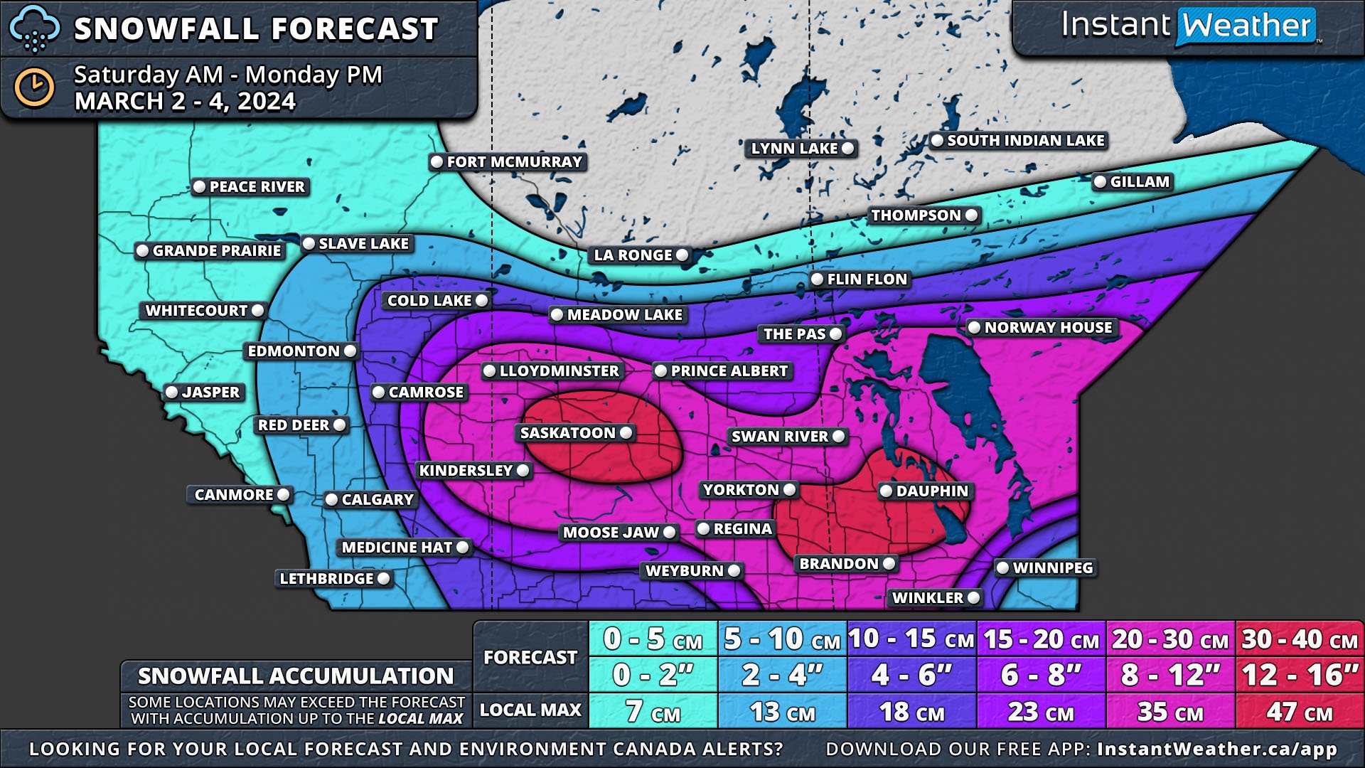
As Saskatchewan welcomes the start of Meteorological Spring, it braces for a significant winter storm, promising a dramatic shift in weather conditions this weekend. Starting Saturday morning, the system will sweep across Southern Alberta and into Saskatchewan, intensifying as it spreads to Southern Manitoba by the afternoon.

This significant storm is forecasted to blanket Southern Saskatchewan with 20-30cm of snow by Monday night, with isolated areas potentially approaching 30-40cm.


GOOGLE AD (NOT ENDORSED BY INSTANT WEATHER)

The storm's journey through Saskatchewan will begin on Saturday afternoon as snow advances from the south. Unlike in Alberta, where moderate to heavy snow is expected to fall primarily on Saturday afternoon and evening, Saskatchewan will face a broader and more intense snowfall.

Much of the central portion of the province is predicted to receive 20-30cm of snow, but two key areas could see accumulations exceeding 30cm. One such area surrounds Saskatoon, extending to North Battleford and Watrous, while another lies along the Manitoba border in the southwest, including Yorkton and Moosomin.

Lasting 6-12 hours and coupled with wind gusts reaching up to 80 km/h, this heavy snowfall may lead to blizzard conditions across vast swaths of the province from Saturday afternoon until late Sunday.


GOOGLE AD (NOT ENDORSED BY INSTANT WEATHER)

As the storm intensifies overnight and continues its eastward trajectory, the threat of severe weather conditions heightens. Saskatchewan residents should prepare for significant snowfall and potential blizzard conditions, which could disrupt travel and outdoor activities.

The combination of heavy snow and strong winds will likely result in reduced visibility and challenging driving conditions across the affected regions.

Significant Blizzard Takes Aim at Manitoba Starting Saturday Night With Up 40cm of Snow Possible

NOTE: YOU CAN CLICK ON THE MAP TO OPEN A ZOOMABLE IMAGE


As we step into March, Manitoba prepares for a significant winter storm, marking a dramatic start to Meteorological Spring. This weekend, a powerful system will sweep across the Prairies, reaching Southern Manitoba by Saturday afternoon and intensifying through the night into Sunday.

This storm is set to blanket Southern Manitoba with 20-30cm of snow, with some regions bracing for as much as 30-40cm by Monday evening. However, Southeast Manitoba will face a unique challenge as mixed precipitation and rain, driven by a warm front, are anticipated to reduce overall snowfall totals in this area.


GOOGLE AD (NOT ENDORSED BY INSTANT WEATHER)

The storm's onset in Manitoba will be characterized by light snow beginning Saturday afternoon, and intensifying into early Sunday morning. As the storm's core advances across the Saskatchewan border, Southern Manitoba will be enveloped by heavy, wet snow. This will result in widespread snowfall accumulations of 20-30cm across a broad expanse of the province. Locations such as Russell, Dauphin, Neepawa, and Virden, extending across Lake Manitoba into the West Interlake Region could see up to 40cm of snow.

With wind gusts nearing 80 km/h, blizzard conditions are a significant concern throughout Sunday, making travel perilous and visibility severely reduced. Environment Canada has issued a blizzard warning for much of Western Manitoba. The relentless snowfall is expected to persist into Monday morning before gradually tapering off by the evening.


GOOGLE AD (NOT ENDORSED BY INSTANT WEATHER)

In contrast, Southeast Manitoba, including the Eastman Region, the Red River Valley, and Winnipeg, will experience a mix of precipitation types due to the storm's warm front. This warmer air from the south will initially bring light snow, followed by a combination of ice pellets, freezing rain, and rain by Sunday afternoon, complicating conditions further.

Although snowfall accumulations will be modest here, the mix of precipitation types will nonetheless create challenging and messy conditions. As the storm progresses northeastward, a brief return to snow is forecasted for late Sunday into the overnight hours.

Major Winter Storm to Dump Up to 40cm of Snow on the Prairies for the First Weekend of March

NOTE: YOU CAN CLICK ON THE MAP TO OPEN A ZOOMABLE IMAGE


Just as we welcome the start of Meteorological Spring, the Prairies are bracing for a significant winter storm. The storm is set to begin on Saturday morning in Southern Alberta and Saskatchewan, spreading to Southern Manitoba by the afternoon. It will intensify overnight, extending northward and eastward.

By Monday night, Southern Saskatchewan and Manitoba will have received a widespread 20-30cm of snow, with isolated areas seeing 30-40cm. Southeast Manitoba will experience mixed precipitation and rain due to a warm front associated with the storm, which will limit snowfall totals there.


GOOGLE AD (NOT ENDORSED BY INSTANT WEATHER)

Alberta

In Alberta, light snow will start moving through Southern Alberta on Saturday morning, reaching the Edmonton area by early afternoon. The afternoon will bring moderate to heavy snow east of a line from Camrose through Drumheller to Medicine Hat, extending to the Saskatchewan border. This area is expected to receive 15-25cm of snow, primarily on Saturday afternoon and evening.

The snow will taper off from west to east by Sunday afternoon, though light flurries could persist for the next 24 hours. Wind gusts up to 50km/h on Saturday may cause blowing snow and reduced visibility.

Saskatchewan

Saskatchewan will experience a similar situation, with snow arriving from the south in the afternoon. However, the intensification and heavier snowfall will affect a larger portion of the province, resulting in 20-30cm of snow across its entire width. Two significant areas are expected to receive over 30cm of snow: one centred around Saskatoon, extending to North Battleford and Watrous, and another along the Manitoba border in the southwest, including Yorkton and Moosomin. Heavy snowfall, lasting 6-12 hours and accompanied by wind gusts up to 60km/h, could lead to blizzard conditions from Saturday afternoon until late Sunday.


GOOGLE AD (NOT ENDORSED BY INSTANT WEATHER)

manitoba

In Manitoba, the forecast is more complex. Light snow will start from the south on Saturday afternoon, continuing until early Sunday morning. Then, heavier, wet snow from the storm's center will cross the Saskatchewan border. Like in Saskatchewan, extensive areas of Manitoba will see 20-30cm of snow.

The secondary pocket of over 30cm of snow from Saskatchewan will extend into Manitoba, affecting places like Russel, Dauphin, Neepawa, Virden, and the West Interlake Region. Blizzard conditions, with wind gusts up to 70km/h, are a concern across Manitoba on Sunday. Heavy snow will persist until Monday morning and dissipate by Monday evening.

Southeast Manitoba, particularly the Eastman Region, the Red River Valley, and Winnipeg will face different conditions due to the storm's warm front, bringing in warmer air and a mix of ice pellets, freezing rain, and rain on Sunday afternoon. While overall snow accumulations will be lower here, conditions will remain messy. As the storm moves northeastward, snow will briefly return late Sunday into overnight.

The storm's track as it approaches Manitoba could still shift, potentially altering the forecast, especially for Southeastern Manitoba. An updated map may be issued to reflect any changes. A major shift in the storm's path could affect where the warm air intrusion occurs, significantly impacting the type of precipitation experienced in Southeastern Manitoba.

Fast-Moving Alberta Clipper Bringing a Widespread 10-20cm of Snow Across the Prairies Sunday and Monday

NOTE: YOU CAN CLICK ON THE MAP TO OPEN A ZOOMABLE IMAGE


FORECAST UPDATE - FEB. 25 @ 9:30 AM

The Prairies will finish the weekend with some fresh snow, courtesy of a fast-moving Clipper that will begin to move into Alberta overnight tonight. The snow will spread eastward throughout Sunday and most of Monday before making its way into Northern Ontario.

A large swath of Alberta can expect 10-20cm of snow by Monday afternoon with Edmonton and areas to the west being hit the hardest. This region will see snowfall totals approaching 20cm and possibly exceeding that amount locally. Most of this accumulation will occur in the late evening and overnight Sunday before starting to taper off Monday morning. Around Edmonton, the snow is expected to begin in the mid-afternoon and continue until mid- to late-morning on Monday.


GOOGLE AD (NOT ENDORSED BY INSTANT WEATHER)

The snow will cross into Saskatchewan Sunday evening and will spread across Central and Southern portions of the province through the overnight and early morning hours Monday. The heaviest snow will be concentrated to a line across Central Saskatchewan with a drop in snowfall accumulations moving northward and southward. Locations from Lloydminster, though Saskatoon to the Manitoba border can expect 10-15cm of snow throughout the day on Monday.

Things don’t start in Manitoba until early Monday and with the heaviest snow expected for Southern Manitoba as the Clipper continues its east-southeastward trajectory. The swath of 10-15cm will continue into the province from Saskatchewan but will only reach as far as across the Interlake Region because the back half of the storm starts to fall apart, and the snow begins to dissipate through Monday afternoon. Winnipeg, in particular, can expect the snow to be fairly short-lived and last less than 12 hours beginning after midnight Monday and continuing until mid-morning, resulting in less than 10cm of snow.


GOOGLE AD (NOT ENDORSED BY INSTANT WEATHER)

Temperatures ahead of the snowfall will be quite mild, with most of the Prairies reaching highs approaching or surpassing 0°, but they will rapidly plummet down to the negative double digits with the passage of the Clipper. Some areas could even see temperatures as low as -30° Tuesday night. This short blast of cold is expected to last for a couple of days before we return to more seasonal temperatures mid-week.

Parts of Saskatchewan and Manitoba to Receive 10–20cm of Snow as Colorado Low Moves In on Wednesday

NOTE: YOU CAN CLICK ON THE MAP TO OPEN A ZOOMABLE IMAGE


A Colorado Low is on course to impact Southern Saskatchewan and Manitoba as the week draws to a close, promising significant snowfall and challenging weather conditions across the regions.

The journey of the Colorado Low northwards brings the first round of snow to Saskatchewan from the south, beginning overnight Tuesday and carrying on into Wednesday morning. The main band of snow is expected to catch up by late Wednesday morning. Along the American border in the southeast of the province, there may be a bit of mixing due to slightly warmer temperatures. 


GOOGLE AD (NOT ENDORSED BY INSTANT WEATHER)

The snow is set to continue unabated through Thursday, beginning to dissipate from west to east Thursday afternoon and concluding entirely by the end of the day. The heaviest snowfall is anticipated in the Southwest and West Central regions, where a broad swath could see accumulations of 10-20cm. This 10-20cm zone also extends into Southeast Saskatchewan, covering a significant portion of the province with a hefty blanket of snow.

The influence of the Colorado Low extends into Manitoba by Wednesday evening, with snow initiating in the southwest and gradually expanding northward throughout the night. By Thursday morning, the snow could intensify, particularly in the Parkland and Westman Regions, where it may fall heavily at times. The storm is expected to exit the region late Friday evening. 


GOOGLE AD (NOT ENDORSED BY INSTANT WEATHER)

A widespread accumulation of 10-20cm is forecasted across Southern Manitoba. However, in the Red River Valley and the Eastman Region, snowfall totals are predicted to be less than 10cm. This is due to mixing with rain as temperatures hover just above the freezing mark, limiting the accumulation of snow in these areas.

Break in Extreme Cold for Alberta; Calgary & Lethbridge Area Could See Up to 30cm of Snow This Week

NOTE: YOU CAN CLICK ON THE MAP TO OPEN A ZOOMABLE IMAGE


After enduring several days of extreme cold, Alberta is set to receive some respite starting Tuesday. This change will introduce milder air, which is expected to bring significant snow to parts of southern Alberta from Tuesday morning through Wednesday night and into Thursday morning.

Light snow is forecast to begin moving across the Rockies early Tuesday morning in the Foothills, gradually shifting southeastward throughout the day. Due to this track, Edmonton is likely to see little to no snowfall. However, the Calgary area will be affected as the snow advances into the region by Tuesday evening. The snowfall is expected to persist over Calgary for a full 24 hours, potentially accumulating up to 20cm by the end of the event.


GOOGLE AD (NOT ENDORSED BY INSTANT WEATHER)

Further south of Calgary, encompassing areas like High River, Lethbridge, and Taber, the snow is anticipated to continue for an additional 6-12 hours. This extended period of snowfall could lead to higher total accumulations, potentially reaching up to 30cm. There's also a chance that localized areas in this region could experience up to 35cm of snow by Thursday morning when the snow is expected to finally taper off.


GOOGLE AD (NOT ENDORSED BY INSTANT WEATHER)

Alberta Clipper Could Dump Up to 20cm of Snow on Parts of Southern Manitoba Over Next Few Days

NOTE: YOU CAN CLICK ON THE MAP TO OPEN A ZOOMABLE IMAGE


The Alberta Clipper that has taken a single day to make its way across Alberta and Saskatchewan Tuesday will cross into Manitoba overnight. It’s expected to slowly pass through Southern Manitoba, and it will bring snow to the region until Thursday morning.  


GOOGLE AD (NOT ENDORSED BY INSTANT WEATHER)

The snow will be heavy at times and a large swath of Southern Manitoba, stretching from the Saskatchewan border and southeast into Winnipeg can expect 10-15cm of snow.

The City of Winnipeg and surrounding area will be on the lower end of that range and residents here can expect closer to 10cm of snow. Meanwhile, to the west and northwest, especially in the higher elevations of the Escarpment, snowfall totals will approach 15cm.

An area that includes Swan River and Dauphin can anticipate even more snow as the Clipper will stall over this region for several hours and eventually leading to upwards of 20cm of accumulation.

Most of the rest of Southern Manitoba can expect 5-10cm before the snow dissipates early Thursday.


GOOGLE AD (NOT ENDORSED BY INSTANT WEATHER)

Alberta Clipper to Bring Widespread 10-15cm to Alberta and Saskatchewan Beginning Tuesday

NOTE: YOU CAN CLICK ON THE MAP TO OPEN A ZOOMABLE IMAGE


Nothing says January in the Prairies quite like negative double-digit temperatures and an Alberta Clipper bringing a healthy dumping of snow which is exactly what many can expect to see over the next couple of days.

The snow will start to make its way into Alberta from the Rockies shortly after midnight Tuesday and spread across Central and Southern Alberta through the morning hours.


GOOGLE AD (NOT ENDORSED BY INSTANT WEATHER)

The heaviest snowfall is expected to fall in Central Alberta, covering a swath from Grande Prairie and Grande Cache and through Edmonton to Wainright and Lloydminster.

This region, along with the Rockies, falls under the 10-15cm range for snowfall. Areas closer to the Rockies and in the Foothills can be expected to be closer to 15cm and potentially up to 20cm locally while Edmonton and eastward will be closer to 10cm. 

This will be a fairly short-lived event for Alberta with the hardest hit areas only receiving snow for a maximum of 12 hours and snowfall rates aren’t expected to be particularly high so overall accumulations will be limited. By early Wednesday morning, the snow will end for the province.


GOOGLE AD (NOT ENDORSED BY INSTANT WEATHER)

NOTE: YOU CAN CLICK ON THE MAP TO OPEN A ZOOMABLE IMAGE

In Saskatchewan, the snowfall will begin to cross the border in the late morning and once again, the Central region of the province will be the hardest hit area with 10-15cm expected to fall.

This encompasses an area from Lloydminster and Kindersley, across Saskatoon and eastward to Hudson Bay and Yorkton. Wednesday morning will see the system stall after it crosses the border with Manitoba and East Central Saskatchewan will likely be on the higher end of the 10-15cm range along with the possibility of higher snowfall totals locally by the time the snow ends overnight Wednesday into early Thursday.

After finally crossing the border into Manitoba, the system will once again stall over Southwestern Manitoba. At this point, there is some disagreement between weather models regarding exactly how much snow this region can expect and a slight change in speed or trajectory could make a big difference in accumulation totals. As a result, we will be holding off on publishing a forecast until Tuesday evening.

Return to Reality for Alberta With Quick Blast of Winter Weather Bringing Up to 5-10cm of Snow

NOTE: YOU CAN CLICK ON THE MAP TO OPEN A ZOOMABLE IMAGE


After some very unseasonable warmth recently, the reality of winter returns with a quick blast of snow across parts of Southern Alberta along with temperatures closer to what we expect for this time of year.

Beginning Thursday morning, a clipper will start to push its way eastward from the Rockies and into Southern Alberta by the afternoon. An area from Jasper and Banff, east to Edmonton and Red Deer can expect the greatest accumulation, with upwards of 10cm by the time the snow dissipates mid-morning Friday.


GOOGLE AD (NOT ENDORSED BY INSTANT WEATHER)

There is still some disagreement between weather models, with some suggesting a more northern track that would bring some heavier snow to Edmonton, resulting in a messy evening commute for the city.

Outside of Edmonton, travel along the Yellowhead and QE2 between Red Deer and Edmonton will also be messy during the afternoon and evening.

With this quick blast of snow comes one of the final chances for a White Christmas with very little additional snow expected between now and the 25th.

Temperatures are not expected to rise far above freezing over the next week and a half so locations that receive accumulation from this clipper should expect the snow to stick around until Christmas Day.


GOOGLE AD (NOT ENDORSED BY INSTANT WEATHER)

Alberta Clipper Bringing Up to 20cm of Snow to Southern Manitoba Starting Late Thursday

NOTE: YOU CAN CLICK ON THE MAP TO OPEN A ZOOMABLE IMAGE


An Alberta Clipper has already begun to move into the region, bringing rain and some mixed precipitation along the leading edge. The rain will transition over the snow this evening and overnight as it moves southeastward.

The snow will continue to be steady throughout the day Friday, with the heaviest snow falling over a swath from Virden, through Dauphin and Beren’s River, to the Ontario border during the morning.


GOOGLE AD (NOT ENDORSED BY INSTANT WEATHER)

The area can expect snowfall totals exceeding 15cm and approaching 20cm with the possibility of locally higher amounts.

By the late afternoon and into the evening, the heaviest band of snow will move into the Winnipeg area and Southeast Manitoba where closer to 10cm of snow is expected.

The snow will continue to move southeast overnight and into Saturday and will completely leave the region by early to mid-morning Saturday. Strong wind gusts of up to 70km/h are also expected which will greatly reduce visibility with blowing snow.


GOOGLE AD (NOT ENDORSED BY INSTANT WEATHER)

Alberta Clipper to Bring Heavy Snow and Freezing Rain Risk Across Saskatchewan and Manitoba on Sunday

NOTE: YOU CAN CLICK ON THE MAP TO OPEN A ZOOMABLE IMAGE


A low-pressure system from Alberta has already begun making its way into Saskatchewan and towards Manitoba. Overnight tonight, snow and freezing rain will develop in Eastern Saskatchewan, and it will continue until late Sunday morning as the system continues to push eastwards.

In Manitoba, the precipitation will begin later, starting in the morning on Sunday and it is expected to continue throughout most of the day. Less than 5mm of ice accretion is expected, but a large part of Western Manitoba will be affected.


NOTE: YOU CAN CLICK ON THE MAP TO OPEN A ZOOMABLE IMAGE

Snowfall amounts will be more widespread in Manitoba than in Saskatchewan with considerably higher totals. In particular, the Interlake Region and east of Lake Winnipeg could see over 10cm of snow by the end of the day Sunday.


GOOGLE AD (NOT ENDORSED BY INSTANT WEATHER)

NOTE: YOU CAN CLICK ON THE MAP TO OPEN A ZOOMABLE IMAGE


Similar to Manitoba, total ice accretion in Saskatchewan will be less than 5mm, however, this will be enough to make surfaces slippery if left untreated and there is the potential for broken tree branches.


NOTE: YOU CAN CLICK ON THE MAP TO OPEN A ZOOMABLE IMAGE

Snowfall amounts in Saskatchewan will mostly remain less than 5cm except for an area around Hudson Bay, where up to 10cm could fall. The freezing rain will fall further south of the snow and some areas may see a mix of both snow and freezing rain.


GOOGLE AD (NOT ENDORSED BY INSTANT WEATHER)