‘Snow Day’ Forecast: Heavy Snow May Delay Return From Holiday Break for Some Students in Southern Ontario on Monday
/For an updated list of school bus cancellations & school closures, please visit our live article: https://instantweatherinc.com/article/2026/1/5/bus-cancellations
After a two-week break from school across Southern Ontario, it’s understandable that many students and parents are ready for a return to normal with the first official school day of 2026. Unfortunately, the timing is far from ideal. An approaching Alberta Clipper is expected to sweep across the region overnight Sunday into Monday, delivering a burst of heavy snow right during the height of the morning commute.
Environment Canada has already begun issuing widespread snowfall warnings ahead of this system, highlighting the potential for 10 to 15 cm of snow by Monday, along with periods of reduced visibility. With snow falling at a steady rate through the early morning hours, it’s quite possible that winter break may be extended by at least one more day in some parts of Southern Ontario.
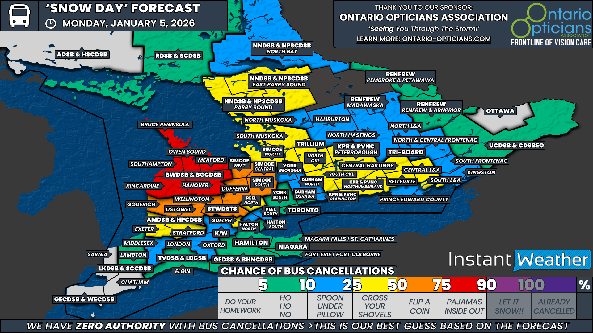
The highest confidence for a snow day sits squarely within the Bluewater District School Board. This entire region is expected to see the most snowfall from the Alberta Clipper, on top of already significant snowpack left behind by persistent lake effect snow over the past week. Wind gusts approaching 40 to 50 km/h may also lead to areas of blowing snow, especially in open and rural locations.
With heavy snow beginning overnight and continuing into Monday morning, conditions are likely to deteriorate quickly. Because of this, we are leaning strongly toward school bus cancellations across the entire Bluewater region.
Surrounding school boards fall into a more uncertain category. Northern portions of Huron and Perth counties under the Avon Maitland District School Board, Wellington and Dufferin counties within the Upper Grand District School Board, and the Simcoe West, Central and South weather zones under the Simcoe County District School Board have all been assigned a 50 percent chance of a snow day.
These boards tend to operate with a higher threshold for cancellations, and while 10 to 15 cm of snow is impactful, it sits close to that decision line. Confidence here will depend heavily on snowfall rates during the morning commute and how quickly conditions deteriorate.
Farther south and east, the heavy snow threat will extend into portions of the Greater Toronto Area, including Peel Region, York Region, the City of Toronto and Durham Region. While these areas are expected to see accumulating snow, the more urban nature of these boards typically results in fewer cancellations unless snowfall becomes extreme. As a result, these regions carry a very low to low chance of school bus cancellations on Monday.
To the north and east of the core snow zone, we have assigned a 25 percent chance for several school boards that cover large rural areas and are more sensitive to winter travel conditions.
This includes Parry Sound and East Parry Sound within the Near North District School Board, Simcoe North under the Simcoe County District School Board, South Muskoka along with North and South Kawartha Lakes under the Trillium Lakelands District School Board, Peterborough and Northumberland counties within the Kawartha Pine Ridge District School Board, and Central Hastings, Belleville and Central and South Lennox and Addington under Tri-Board Student Transportation Services.
While we are leaning toward a normal school day for most of these regions, uncertainty remains given the potential impact on untreated rural roads during the morning commute.
Elsewhere across Southern Ontario, including the Ottawa Valley, Deep Southwestern Ontario and areas along the Lake Erie shoreline, the chance of a snow day appears fairly unlikely. In the Ottawa Valley, snow is expected to arrive later in the day, after the morning bus run. For regions closer to Lake Erie, snowfall amounts should remain minimal as the system tracks farther north, limiting impacts.
As always with Alberta Clippers, small shifts in timing or intensity could make a noticeable difference Monday morning. We’ll continue to monitor conditions closely and provide updates as needed, but for now, the return to school may be delayed for some, while others should prepare for a snowy start to the week.
Disclaimer: Instant Weather has zero authority when it comes to bus and school closures.
It is completely up to the school boards, bus companies, local authorities, and parents to decide what is best for their children. This is our best guess based on our forecast.


