
Winter Storm! Snow for Vancouver, As Much as 2 Feet! Over Higher Terrains and Mountains
/Issued: November.11,2020 @ 5 PM
Updated: November.11, 2020 @ 5 PM
Forecaster: James Follette

Good Afternoon! We have a lot to talk about in today’s forecast! Although for many areas around the province it’s a nice sunny but cold day! We also have some showers that came through Victoria and Vancouver over the last few hours, The RGEM FutureCAST model has done a really good job in forecasting that.
Last night, I was leaning more on the NAM and ECMWF model, but now that I see the showers came about as the RGEM and GEM model forecast.
This doesn’t really change much in the forecast for the lashing winter weather we are about to get!!
A very strong and moisten storm will begin to arrive very late tonight into the day Thursday and then another storm comes in on Friday through Saturday morning.
So there are 2 separate storms and both of them will deliver something different to some parts along with Vancouver.
Storm 1: Late tonight into Thursday, Heavy snow at times for Inland Vancouver and Metro, Downtown Vancouver could even see a few slushy inches! But head far inland towards the North district of Vancouver and Port Moody to Coquitlam that is where you could see several inches of snow!
Along with the snow, is the heavy rain that would lash the coastal areas with as much as 50 to 75 mm of rain by the time that Saturday morning rolls around.
Winds will not be too strong as they will mainly stay south, but Gusts to 40-60 km/h is very likely.
Storm 2: Late Thursday night into Saturday morning, Heavy snow will continue to fall in the very high elevations and far inland. But snow will become rain over much of the entire Vancouver area, Snow in the mountains will continue to pile up, seeing as much as 2-3 feet! in lower elevations inland, up to 15-30cm is expected! The Interior could see another 5-15cm.
Rainfall will continue to fall on the coast, and become a bit heavier.
Winds will be stronger in this storm, gusting up to 80 km/h in Vancouver and Victoria and along the coast. Inland can see gusts up to 70 km/h.
So with all this rain, snow & wind, it is very likely we can see power outages.

Looking at the FutureCAST timing this out over the next 3-4 days. This is the RGEM model and it’s doing a pretty good job so far in today’s forecast!
So Nice today, other than some flurries far inland and a few showers in Victoria and Vancouver. The heavy rain and snow arrive in the early hours of the morning so expect snow for inland Vancouver, a mix to mostly rain in the Metro of Vancouver and along the coast, Victoria will stay all rain for both systems.
The next system is a bit stronger and will sink south of Victoria, this will bring wind-driven rain for much of Vancouver and along the coasts & islands. But snow at times heavy will continue to fall for far inland areas and mountainous terrain.
By Saturday morning we finally begin to clear up a little.

Here is the models’ projection on snowfall over the next 3 days into Saturday, notice the bright pink-purple like colors? that is amounts of over 2-3 feet! This will fall over the higher terrains and mountainous areas. But Vancouver Inland… 5 to 15 cm over the North District of Vancouver, a few inches for the Metro and as head far north of Vancouver District, up to 30cm can fall! Vancouver Island Inland areas could see as much as 25 to 30cm of snow, coastal areas near the water will see much less with amounts of up to 5cm.
for the rest of the province, here is what you can expect in possible snowfall.

Interior can see as much as 15cm, possibly more can not be ruled out! Further north more to the east, you will see far less snow, as the system will ne further away from you, Amounts of a few cm’s.
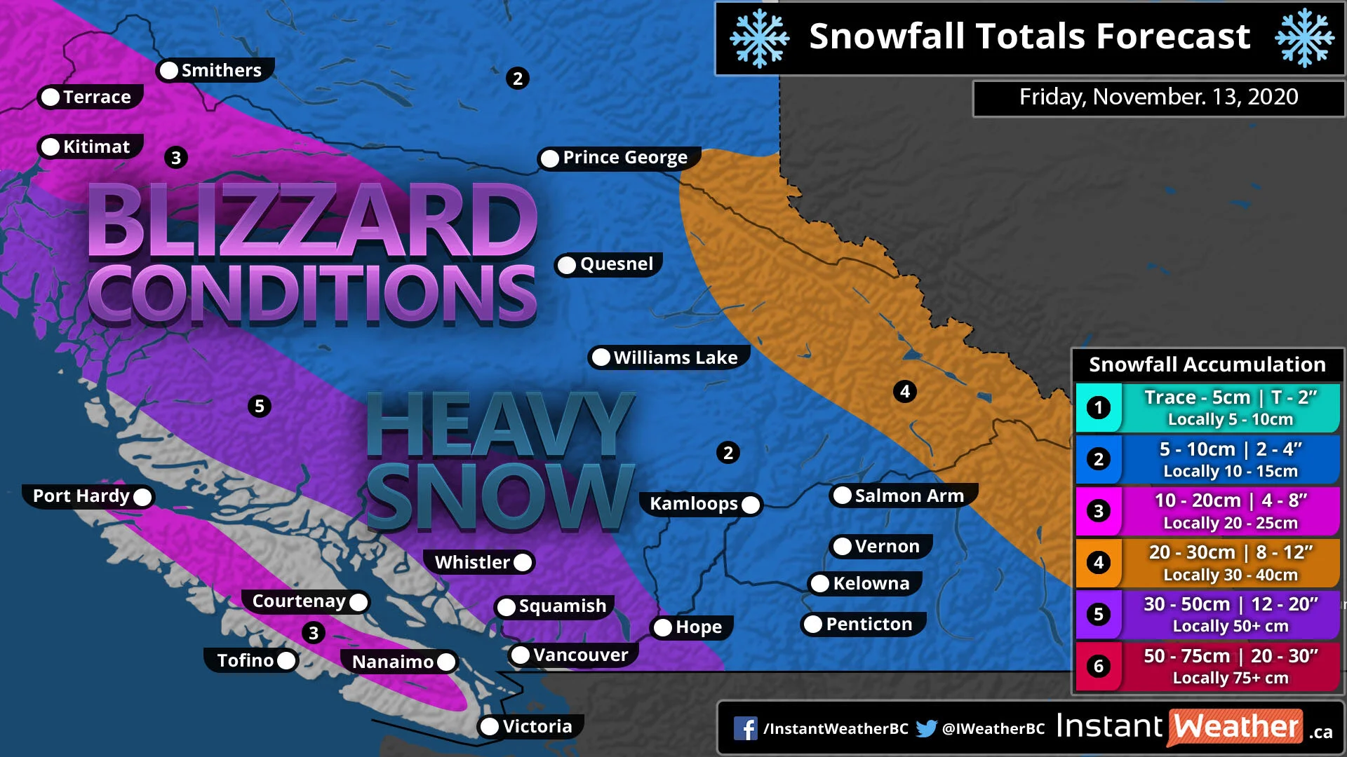
Here is what you can expect in my snowfall forecast!
Vancouver Island: 10-20cm with locally up to 25cm in the inland areas.
Inland Vancouver, Whistler, and Squamish to Hope you will see the highest amounts! depending on where you are, the higher up you are in the elevations the more snow you will get and those areas will see up to 50cm and lower elevations could see just 25cm.
For the Interior and much of mainland BC, look for about 5 to 10cm, however, could be some local amounts of up to 15cm.
Then we get to the Rockies into AB border, expect upwards of 30cm with local amounts near 40cm.

With the 2 combined storms, there is going to be a lot of precipitation water! now this includes all types of precipitation including snow! The areas that will see rain, such as along the coasts and in Vancouver, Vancouver Island Coastal areas. a good 50 to 75 mm of rain will likely fall by Saturday morning.

For rest of BC, look at a good 10-30 mm of water in snow form! and with super cold temperatures far north and over mountains and high elevations that will produce a very high snow ratio and that is why the amounts are higher in those areas. The colder it is, the more snow will fall!

Here is my thoughts on the rainfall amounts through Saturday, A wide swath of a good 30-50mm with locally up to 70mm! And honestly, with the models being in a good agreement on showing 50 or more, I may tick that up in tonight’s forecast from 30-50 to 50-75mm. Either way, expect a flooding rain! You are wanting to make sure to unclog your storm drains so that the water call flow down into the sewer and not get clogged and create street flooding.

So for today, expect a chance of flurries or rain showers as that has been the case this afternoon from Squamish to Vancouver and for the South-East parts of the province.

Then we get into Thursday!, There is that Low pressure just near Vancouver Island. A good soaking rain much of the coast, Very heavy snow inland and it will also be breezy at times with gusts up to 40 or 50 km/h. and from Prince George to the Okanagan looking at some Flurries.

Then we have storm #2 for Friday! Low pressure over Vancouver island will sink south and curve up the coast. A nasty snow storm for Vancouver Island, and many parts of the coast, with exception of near Vancouver will you will be all rain!
Parts of the Interior from Kamloops to Hope, can look at a steady snowfall with blowing snow and potential blizzard conditions at times.
Strong winds on the coasts will gusts upwards of 60-80 km/h and that will create some blizzard conditions.

For the rest of today, expect sun and clouds for much of everyone, except some flurries in Kelowna and even some showers in Vancouver and Victoria late this afternoon and evening. Storm arrives in Vancouver to Victoria later overnight with a mix bag in Vancouver and rain in Victoria. Highs of 4-7 degrees, and lows tonight dipping down to -5 in Kamloops to as warm as +3 in Victoria.

Here in the city, expect gorgeous sunshine today, however again there is that shower chance in the afternoon hours. highs on the chilly side! only 3-6 degrees. South-West winds on the light side at only 5-10 km/h.

Today, Sunny & cold with a chance of showers late in the day, high of 6. a slight chance of rain-snow mix overnight tonight with lows dipping down near the freezing mark at 1 degrees.

Here is your 7-day forecast, We are nice today, slightly breezy and cool with possible showers on the coast. high of 7. Colder tomorrow with a winter storm on our steps, snow inland, rain/mix on the coast. cold! highs only around 5 degrees!
Storm# 2 arrives on Friday, this time it is all rain and gusty winds to 80 km/h. That rain byway will be very heavy at times and some flooding is likely. milder at 7! lows of 4.
We continue to warm up on Saturday with lots of clouds but the precipitation stays far to the North sand South of us to not give us a bother. Sunday is also dry and slightly cool at 7. So your weekend is dry and cool but not a stormy one like Thursday & Friday so the weekend will be a great time to get out.
And getting out on the weekend will be a great idea because look what is coming for the start of the new week! YUP! another storm, this one though is all rain, lot’s of it! more flooding problems, strong winds. But the best part is that it is not a very cold rain, in fact, the temperatures will rise into the low 10’s!
I’ll have a better update on the 2 storms, and your latest updated forecast! coming up later tonight!
Have a safe Remembrance day, Remember to wash your hands, keep 6ft apart, and wear a mask! The more people that do this, the more quickly we can go back to normal!
Be safe, Be well, Buh-Bye!


