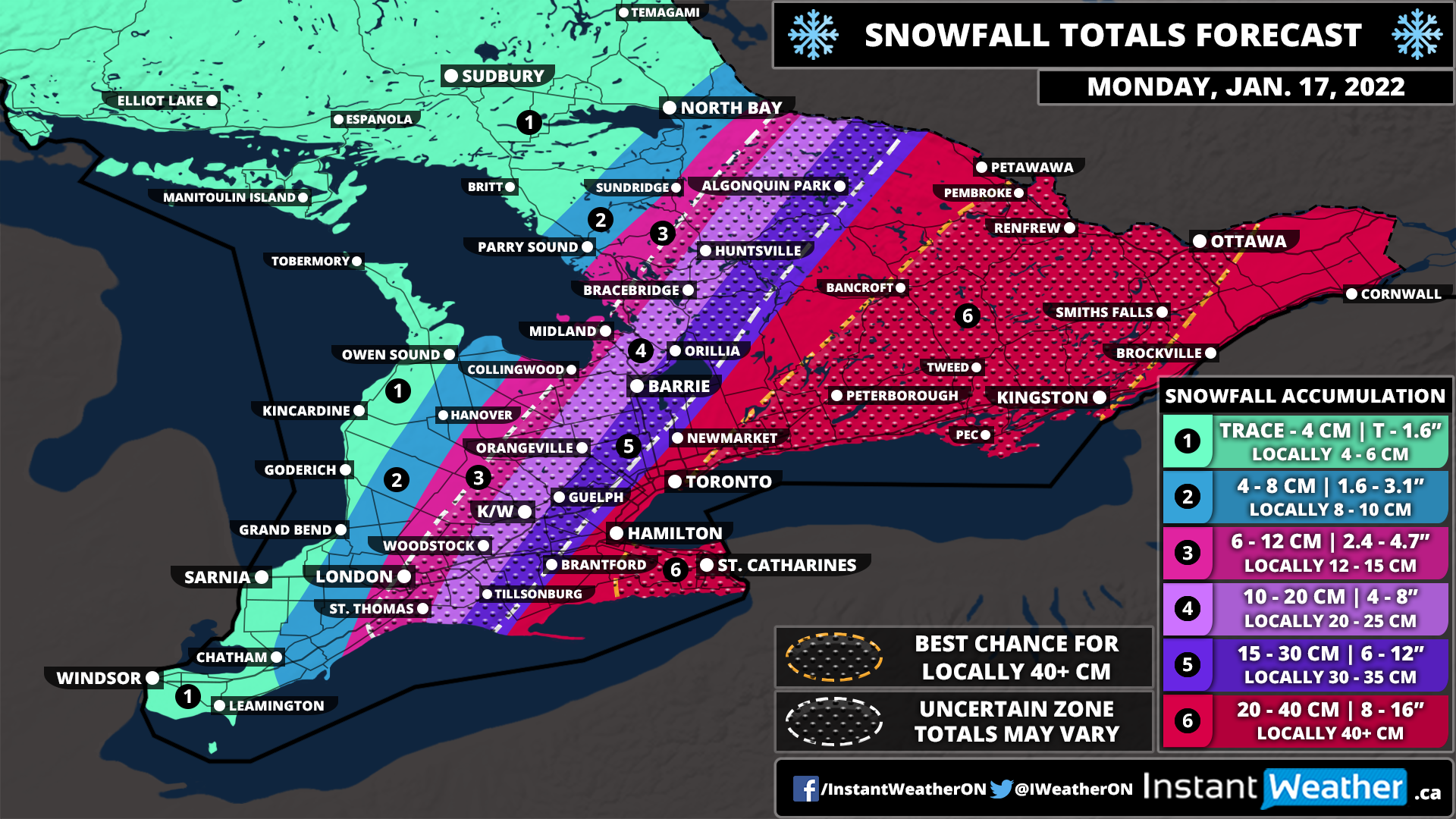
UPDATE: Monday’s Snowstorm Shifts Further West Bringing the Threat of 20+cm of Snow Into the GTA and Central Ontario; Up to 50cm of Snow Possible for Niagara and Eastern Ontario

It’s becoming increasingly likely that Southern Ontario will be hit with one of the strongest snowstorms that we’ve seen in quite a long time starting Sunday night and lasting into Monday. We’re starting to get a clearer picture on the exact track of this system and it’s probably the worst-case scenario in terms of impact on big population centres including the GTHA, Kingston and Ottawa.

Recently, the track of the system in model runs has consistently held further to the west even though these systems tend to track eastward at the last minute. To account for this possible eastern trend, we kept the higher snowfall totals further east in previous forecasts. However, it’s clear that is very unlikely to happen this close to the event and not much deviation in the current track is expected.

The biggest change we’ve made to our forecast is shifting the expected accumulation further to the west. This means that the Hamilton, Toronto and Durham area is now within our heaviest snowfall total zone with the expected accumulation ranging from 20-40cm.

You might notice that we’ve changed the top accumulation from 25-40cm to 20-40cm. This doesn’t mean that we’re expecting this storm to be any weaker and in fact, it could be stronger than expected and we might even see some thundersnow! The only reason we did this was so we can include the GTA into the higher totals which still accounts for the potential that the heaviest snow bands just remain to the east and they top out around 20-25cm. It’s still fairly unlikely as more models show totals over 30cm for the GTA than models that show less than 25cm.

In addition to this, there is growing confidence that parts of Eastern Ontario along with the Niagara region could approach 50cm of accumulation in localized areas. We have also expanded this zone further west to include Peterborough and eastern sections of Hamilton as models indicate this area could exceed 40cm as well. It still appears that Kingston and the Ottawa region will come out of this event with the most snowfall ranging from 40-50cm, but depending on the track it could shift slightly to the west.

The westward shift in our forecast will also affect the London, K/W, Barrie and Muskoka corridor where we’ve boosted their expected totals. It now looks like that accumulation ranging from 10-25cm is possible for those regions with lower totals the further west you go. Barrie/Orillia and Guelph will likely see close to 20cm with K/W and Muskoka picking up around 10-15cm. London will likely see around 6-12cm although the potential is there for up to 15cm if it tracks even further west.

As shown on our latest map, there is still some uncertainty in that area to the west of the GTA due to the extremely tight snowfall gradient. We’re starting to get more confident in the exact snowfall totals and as such has tightened the ‘uncertain’ zone and shifted it further west. However, a slight shift in the track could mean the difference between 5 and 15cm so don’t be surprised if this storm under or over performs the forecast in your area if you fall within this zone. The more confidence is in the GTA and Eastern Ontario where a minor shift in the track won’t make much of a difference.


Suggested Article


Regional Timing

TIP: You can click on either timeline graphic to open a zoomable version of the graphic.

The first bands of precipitation from this system will begin to affect areas around Lake Erie late Sunday evening close to the midnight hour including the Niagara Region and GTHA. The snow will be quite light for the first few hours, but don’t let that fool you! It will quickly pick up in intensity later in the overnight hour as the centre of the low tracks up the US East Coast. The heaviest snowfall will occur during the mid to late morning hours on Monday which is probably the worse timing for the morning commute. This is when there is the risk for blizzard-like conditions and blowing snow as the winds pick up around sunrise on Monday.

Eastern Ontario and parts of Central Ontario will see snow starting overnight with the worst conditions during the late morning and early afternoon on Monday. Refer to our timeline graphic above for more precise timing information for your region and on when to expect the heaviest accumulation.

We should begin to see the snow clear out starting with those further west by the late morning hours in Southwestern Ontario. The clearing will happen during the mid to late afternoon for much of the GTA and into Central Ontario. Eastern Ontario will continue to hold onto the heavy snow past the dinner hour before tapering off by midnight.

Stay safe! If you’re prepared for this storm, there’s nothing to worry about! Just be careful and try to avoid travel on Monday if you can. It will be over by the end of Monday except for the lake effect snow and the conditions will improve as we head into Tuesday. Continue to check back for any last-minute changes, but it’s unlikely the forecast will differ that much far from what we have currently. Consider this our final forecast for this event unless there’s a very unexpected change at the last minute.

Potentially Strongest Snowstorm in Years To Bring Up to 20-40cm of Snow to Parts of Southern Ontario Starting Sunday Night; Localized Blizzard Conditions Possible Monday Morning

For several days now we’ve been monitoring an impactful system that is expected to bring heavy snowfall to parts of Southern Ontario starting late Sunday. Although there has been a significant amount of disagreement with the exact track of this system amongst the different weather models which have made it hard to give a precise forecast until now.

It was possible that the system could track further east and miss much of our region, but we’re just over 24 hours from the beginning of the event and confidence is growing in the general track of the system. That track has shifted even somewhat further to the west compared to the data we were using in our preview forecast on Friday. As a result, we have now pushed the significant snowfall accumulation of 15+cm to include much of the Golden Horseshoe and into regions east of Lake Simcoe.

This storm is shaping up to be possibly the most impactful snowstorm for parts of Southern Ontario that we’ve seen in several years. Of course, there isn’t much competition as the last few winters have been fairly quiet when it comes to major storms. This storm is special in particular as it’s uncommon for locations outside of the traditional snowbelt in Southern Ontario to see up to 40cm in such a short timeframe.

The intensity of the snowfall (approaching 4-8cm/hour) at the height of this event early Monday morning will lead to rapid snowfall accumulation and a significant impact to travel. Strong wind gusts ranging from 40-60km/h combined with the heavy snow will likely result in blowing snow and localized blizzard conditions during the morning on Monday. It’s almost certain that we see widespread school bus cancellations and school closures just as students return to in-person learning on Monday.

It’s important to note that the track could still shift by a few kilometres even within 6-12 hours before the start of the snow so this will be the one event where what we call ‘nowcasting’ is very important. Adjustments to the expected accumulation may need to be made up to a few hours before the event starts.

That few kilometres might not seem like a big difference and with most systems, it generally doesn’t make a difference. However, this system has a very tight snowfall gradient where the difference between 5cm and 40+cm could be a matter of a few dozen kilometres. We have included the zone on our map (shown in the white hatched circle) where we are less confident in the exact accumulation due to the tight gradient and could go up to down a level on our legend in a future update.

The higher confidence for this system is in the far eastern and western edges of our forecast where the exact track won’t significantly change the forecast. Just keep in mind that this is far from set in stone and don’t be shocked to see some changes on Sunday based on the latest data. We should hopefully have a better idea by Sunday afternoon and even then some last-minute shifts in the track are possible.

Regional Timing

TIP: You can click on either timeline graphic to open a zoomable version of the graphic.

The first bands of precipitation from this system will begin to affect areas around Lake Erie late Sunday evening close to the midnight hour including the Niagara Region and GTHA. The snow will be quite light for the first few hours, but don’t let that fool you! It will quickly pick up in intensity later in the overnight hour as the centre of the low tracks up the US East Coast. The heaviest snowfall will occur during the mid to late morning hours on Monday which is probably the worse timing for the morning commute. This is when there is the risk for blizzard-like conditions and blowing snow as the winds pick up around sunrise on Monday.

Eastern Ontario and parts of Central Ontario will see snow starting overnight with the worst conditions during the late morning and early afternoon on Monday. Refer to our timeline graphic above for more precise timing information for your region and on when to expect the heaviest accumulation.

We should begin to see the snow clear out starting with those further west by the late morning hours in Southwestern Ontario. The clearing will happen during the mid to late afternoon for much of the GTA and into Central Ontario. Eastern Ontario will continue to hold onto the heavy snow past the dinner hour before tapering off by midnight.

Potential Snowfall Totals

The most difficult aspect of this system to forecast will be the potential accumulation that each location receives by the end of the event. As we’ve mentioned above, this is due to the tight gradient that may even result in one side of a particular town or city picking up way more snow than the other side. What we can say with a high amount of confidence is that those in the Niagara Region and much of Eastern Ontario will see the most snow from this storm. Accumulation here will range from between 25-40cm with a zone including St Catharines, Kingston, Smiths Falls and Ottawa that could see locally as much as 50cm.

This will be different from the usual snowfall events that extend 24-36 hours which would lessen the impact. Instead, the bulk of the snowfall will come within a 6-12 hour timeframe and as a result, it’s unlikely that road crews will be able to keep up and travel should be avoided for much of Monday. Just plan to stay home in the hardest-hit regions if possible.

Once we go further west, the confidence in the exact snow totals decreases which includes Brantford, Hamilton, GTA, K/W, Barrie and up into Central Ontario. Right now we have accumulation here ranging from 10-30cm which may seem like a fairly large range, but it’s reflective of the tight gradient which could shift around. We feel it’s important to be transparent in this instead of forcing ourselves to narrow down the range even more which would lead to an inaccurate forecast. You can still look at the accumulation range for your location on that map, but it should be taken with a grain of salt if you are also in the ‘uncertain’ zone as it might go up or down a category on our legend.

And finally, we can say with a fair amount of confidence that areas roughly northwest of a line from London to North Bay shouldn’t see much snow from this event. This includes Extreme Southwestern Ontario (Windsor, Sarnia) and along the Lake Huron shoreline. London up through Barrie and into Muskoka will be right on the edge and can expect to see around 5-15cm with lower amounts further to the northwest. Later on Monday, we will have to watch for the potential for some lake effect snow developing off Lake Huron and Georgian Bay as the storm moves out. Right now, it’s not looking particularly significant, but that can change. More details as we get closer to Monday

Stay safe! If you’re prepared for this storm, there’s nothing to worry about! Just be careful and try to avoid travel on Monday if you can. It will be over by the end of Monday except for the lake effect snow and the conditions will improve as we head into Tuesday. Be sure to check back on Sunday if we need to make updates to this forecast based on the latest data.

Southern Ontario: Winter Weather Hazards Outlook for Sunday, January 16, 2022

Forecast Discussion

Very cold temperatures are possible through Central and Eastern Ontario during the morning on Sunday. Some areas could see temperatures near or below -35°C. A special outlook will be issued on Saturday once we have more data on exactly how cold it will get.

Northern Ontario: Winter Weather Hazards Outlook for Saturday, January 15, 2022

Forecast Discussion

One more night of extremely cold temperatures is ahead for parts of Northern Ontario continuing into Saturday morning. The coldest temperatures will be found throughout Northeastern Ontario including Kapuskasing, Chapleau and Timmins. We expect temperatures as you wake up early Saturday morning to range from -35°C to -40°C in this area with the wind chill making it feel close to or below -40°C. Those closer to Lake Superior and Georgian Bay will be slightly warmer with the minimum temperature between -30°C and -35°C. The rest of Northern Ontario should see temperatures in the -20s but won’t be cold enough to warrant us including it on the map. Temperatures will quickly warm up tomorrow during the day as the cold Arctic air pushes out to the east.

Please be sure to dress accordingly if you’re planning on being outside for an extended period of time. Frostbite and other cold-related dangers can become life-threatening in a matter of minutes with temperatures this cold! And please don’t forget about your furry friends. If it’s too cold for you, it’s too cold for them! Bring them inside or find a way to keep them warm. Stay safe and warm!

EARLY PREVIEW: Snowstorm Could Bring 15-25+cm of Snow to Eastern Parts of Southern Ontario on Monday

A very complex system is expected to track up the East Coast this weekend and has the potential to bring significant snowfall accumulation to parts of Southern Ontario starting Sunday night and continuing through Monday. This type of system is particularly a nightmare to forecast for Southern Ontario since the heaviest precipitation will track right along the American border with a very tight gradient between heavy snowfall and very little accumulation.

A slight change in the track of the system will have big impacts in terms of exactly how much snow will fall on our side of the border and how far west it will encompass. Considering we’re still over 48 hours away from the start of the snow, there’s a lot of time for the track to change as we get closer. However, there is some confidence in some parts of Southern Ontario and how they will be affected by this storm. This includes the Niagara Region and Eastern Ontario (Ottawa, Kingston, Brockville, Cornwall) which is very unlikely to escape this snowstorm unless it tracks significantly further east than expected.

Snow will start to pick up around the Niagara and Hamilton region sometime late Sunday evening or close to the midnight hour. It will continue to spread to the northeast throughout the overnight and into Monday morning. The worst conditions are expected during the early morning hours around Lake Ontario and later in the morning for Eastern Ontario.

Persistent snowfall will continue throughout the afternoon especially for Eastern Ontario, but it will begin to taper off starting from the southwest in the late afternoon and clearing in Eastern Ontario by midnight. Keep in mind this timing may change as we get closer since the system can slow down or speed up - we should have a better idea late Saturday on the exact timing.

There will also be wind gusts ranging from 40-70km/h accompanied by the heavy snowfall so driving conditions will likely be very poor with blowing snow possible. This snowstorm may impact the current plan for schools to return to in-person learning with school bus cancellations highly likely. The best chance at bus cancellations would be through the Niagara Region and Eastern Ontario with the probability decreasing the further to the northwest you go.

It’s a little too early to talk about exact snowfall accumulation due to the significant amount of uncertainty regarding the track of this system. We know that a lot of people do focus on the numbers so we have provided a very rough idea of the potential accumulation from this system. We have higher confidence in the Niagara Region and Eastern Ontario (the closer to the US border, the higher the probability) which could see snowfall accumulation of over 25cm by the end of Monday.

Those in Hamilton, Toronto, Peterborough and Bancroft are right on the line of seeing significant snowfall which makes this forecast very difficult. We’ve outlined the zone on the map (in the white hatched circle) we think could be subjected to very significant changes in the forecast depending on the track. Right now, we can say that there is a fair amount of confidence in accumulation over 10cm for those regions. However, we are being quite cautious with these numbers and some models are showing much higher totals than we’ve shown here. If the system maintains the current track, it wouldn’t be out of the question to see widespread accumulation between 20-40cm.

We believe it’s important to post a forecast this early due to the potentially significant impacts it could have on our region. This is now your chance to plan for a snowstorm and make any alternative arrangements for Monday should it occur. We can’t emphasize enough that this forecast will likely change. The best that can be done is to prepare for the worst and hope for the best, we don’t want you to be unprepared! There’s no harm in being over-prepared.

Check back on Saturday and Sunday for a more detailed forecast once we get more confidence in the track of the storm.

Extremely Cold Temperatures Return to Southern Ontario Tonight Into Saturday With a Wind Chill Between -30°C and -40°C

It should be no surprise to see colder temperatures across the region this time of year considering that we're in the middle of January. However, we’re expecting some of the coldest air of the season so far to make its way into Southern Ontario just in time for the weekend. Now the actual air temperature likely won’t be as cold as we saw earlier in the week, but the difference will be the slightly stronger winds which will make it feel significantly colder than what the thermometer shows.

In some cases, the wind chill will be 5-10°C colder than the air temperature meaning even areas as far south as the GTA could experience wind chills near -30°C on Saturday morning. Further north, it will feel close to -40°C especially over Northeastern Ontario and through the northern parts of Central Ontario.

For the actual temperature, we expect it to range from -30°C to -35°C for those in Northern Muskoka, Algonquin Park, Bancroft and up into Northeastern Ontario. The rest of Central Ontario, around Lake Simcoe and into Eastern Ontario will be slightly warmer with a low temperature of -25°C to -30°C. For the K/W area into Northern GTA away from the lakeshore, the temperature will end up around -20°C to -25°C and closer to -15°C and -20°C for the Lake Ontario and Huron shoreline. The warmest temperatures will be found in Deep Southwestern Ontario and the Niagara region ending up close to -15°C.

These temperatures are the minimum temperatures that will be felt mainly early in the morning and will warm up later in the day. But there won’t be that much of a warmup with most areas seeing a daytime high between -10°C and -20°C. Those in Central Ontario may even struggle to warm up above -20°C. Remember these are the raw air temperature - you have to add 5 to 10°C to the temperature to get the wind chill. We’ve provided a rough estimation of the wind chill on our forecast map above. Another very chilly night is expected on Saturday and continuing into Sunday although the wind chill doesn’t appear to be as big of a factor compared to tonight. More details on that to come on Saturday.

Please be sure to dress accordingly if you’re planning on being outside for an extended period of time. Frostbite and other cold-related dangers can become life-threatening in a matter of minutes with temperatures this cold! And please don’t forget about your furry friends. If it’s too cold for you, it’s too cold for them! Bring them inside or find a way to keep them warm. Stay safe and warm!

Southern Ontario: Winter Weather Hazards Outlook for Saturday, January 15, 2022

Forecast Discussion

Very cold temperatures are possible through Central and Eastern Ontario during the morning on Saturday. Some areas could see temperatures near or below -30°C. A special outlook will be issued on Friday once we have more data on exactly how cold it will get.

Northern Ontario: Winter Weather Hazards Outlook for Friday, January 14, 2022

Forecast Discussion

The extreme cold makes a return to Northern Ontario overnight and Friday morning with temperatures well below -30°C throughout the region. This will likely be the coldest air of the season so far with the extreme cold encompassing all of Northern Ontario instead of just the far northern part of the province. The wind chill could reach into the mid -40s especially around Hudson Bay and between -35°C and -40°C for areas in the south around Lake Superior and Georgian Bay. The actual air temperature won’t be that much different ranging from -30°C to -35°C in the south and near -40°C for those further north.

Of course, the coldest temperatures will be found early Friday morning and warming up later in the day, but not by much with most areas not even reaching a daytime high above -20°C. Another cold night is expected Friday lasting into Saturday morning. This will be covered in a separate outlook for Saturday.

Please be sure to dress accordingly if you’re planning on being outside for an extended period of time. Frostbite and other cold-related dangers can become life-threatening in a matter of minutes with temperatures this cold! And please don’t forget about your furry friends. If it’s too cold for you, it’s too cold for them! Bring them inside or find a way to keep them warm. Stay safe and warm!

Another Winter Storm Heading for PEI

Valid 14 Jan, 2022

…and just like that, our second winter storm of 2022 is heading our way. This one has a number of the same characteristics of last week's storm - significant snow and high winds.

TIMING:

Prince County should see this as a snow event only with the snow starting late afternoon on Friday. Kings County, and possibly most of Queens County will see this system start as rain around lunch time on Friday. By early evening that rain will have a change over to snow in Queens County. We may see some ice pellets in Queens County during that changeover. In Kings County, the changeover will see ice pellets and possibly see some freezing rain. By 10pm, it should be an all snow event. Snow will continue through the overnight into Saturday and will diminish to flurries some time Saturday afternoon.

TOTAL AMOUNTS ACROSS THE PROVINCE:

The below snowfall accumulations are what we can expect to see from Friday evening to Saturday afternoon:
SNOWFALL

Prince County – 30-40 cm
Queens County – 30-40 cm
Kings County – 20-30 cm

WIND: Again, winds will be a factor with this system. Winds will be from the North / Northwest and will gradually increase through the evening hours of Friday and should start diminishing Saturday around noon. The stronger winds will occur between 2am and 10am Saturday. Overall, wind should be 50-70 km/h with gusts of 80-100 km/h n

TEMPERATURE: Friday will start with temperatures hovering around the freezing mark and by supper time Friday, temperatures will begin to go down and will reach lows near -10 by Saturday evening.

Any shift in the front could vary the precipitation types and quantities. We will continue to monitor this system and keep you updated with any significant changes.

Winds and snow will cause white out and hazardous driving conditions. Be prepared for power outages. Please exercise caution if you are on the roads. Saturday will be a day that travel is not recommended. If you do not need to drive, stay home and eat chips. Always adhere to the recommendations of the RCMP and PEI Public Safety.

As always, be safe and let us know what you are experiencing in your areas.

Storm chip Probability: 100%

IWPE Team (Mike S, Harry S)