Snow Day (Bus Cancellation) Outlook for Friday, December 16, 2022

NOTE: You can click on the map to open a zoomable image which might be easier to read due to the small labels. If you prefer our old city label format, we have included that further down this article.

A winter storm continues to affect Southern Ontario this evening and is expected to linger overnight and into Friday morning. The worst conditions will be found in Eastern Ontario where heavy snow will likely result in school bus cancellations on Friday. We’ve already seen the Catholic District School Board of Eastern Ontario (CDSBEO) and Upper Canada District School Board (UCDSB) announce tonight that they’re proactively cancelling school buses for Friday. Based on the expected conditions, it’s almost certain that other surrounding school boards including Ottawa, Renfrew and Kingston will follow suit in cancelling school buses or even closing schools on Friday.

Further west, the probability of school bus cancellations will diminish as the snow will end overnight for those regions. We have the Peterborough and Lindsay area at a 75-90% chance of a snow day while northern Durham and Haliburton have a 50/50 chance. The rest of Central Ontario into parts of Southwestern Ontario and the GTA is unlikely to see school bus cancellations on Friday, however, there is a slight chance based on the potential for slushy and icy roads overnight with temperatures hovering near the freezing mark.


FORECAST MAP WITH CITY LABELS


Disclaimer: Instant Weather has zero authority when it comes to bus and school closures. It is completely up to the school boards, bus companies, and local authorities as well as the parents to decide what is best for their children. This is simply our best guess based on our forecast.

Snow/Ice Day (Bus Cancellation) Outlook for Thursday, December 15, 2022

NOTE: You can click on the map to open a zoomable image which might be easier to read due to the small labels. If you prefer our old city label format, we have included that further down this article.

The first significant snowstorm of the season is expected to affect Southern Ontario beginning Thursday morning with heavy snowfall and prolonged freezing rain. A storm of this magnitude would typically result in widespread school bus cancellations in many regions, however, the worst of the conditions won’t start until later in the morning or early afternoon when the decision to cancel buses has been made hours before.

This will mean that the chance for a ‘snow/ice day’ rests on each school board proactively taking the afternoon’s forecast and alerts from Environment Canada into consideration when deciding in the morning. This tends to be hit or miss with some school boards having a better track record when it comes to proactive cancellation so we’ve factored this into the forecast.

The highest chance of school bus cancellations exists in Southwestern Ontario where a freezing rain warning is in effect and will be ongoing during the early morning hours. We have given this area a 75% chance of a snow day with the more urban areas (London, K/W, Guelph and Hamilton) having a slightly lower chance at 50%.

For Central and Eastern Ontario, there is less certainty as the snow will start later in the day and will again be dependent on boards being proactive. We believe the Kingston and Belleville region is quite likely to see a snow day because that school board has shown a history of considering the forecast when deciding along with Environment Canada issuing a strongly worded snowfall warning. Other school boards are a toss-up at this point and could go either way.

It’s unlikely we will see school bus cancellations in the Niagara, Toronto, Barrie or Ottawa regions as they tend to be more strict with bus cancellations and a weather advisory usually isn’t enough.


FORECAST MAP WITH CITY LABELS


Disclaimer: Instant Weather has zero authority when it comes to bus and school closures. It is completely up to the school boards, bus companies, and local authorities as well as the parents to decide what is best for their children. This is simply our best guess based on our forecast.

Disruptive Winter Storm Targets Southern Ontario Starting Thursday With Heavy Snow and Significant Freezing Rain Risk

NOTE: You can click on the map to open a zoomable image which will be easier to read.

The next few days are going to be quite messy across Southern Ontario as our first winter storm of the season takes aim at the region. The exact impacts of this storm will be very location dependant ranging from up to 15-30cm of snowfall accumulation to a prolonged freezing rain risk. In addition to the wintery weather, strong to damaging wind gusts are expected to accompany the system on Thursday which could pose additional risks when combined with the heavy snow and freezing rain.

Precipitation in advance of the approaching low-pressure system will reach Deep Southwestern Ontario by the early hours of Thursday. This system will tap into some warm air from the Gulf of Mexico which is expected to clash with the colder air currently over the province. The warm air will win out for regions further south including Windsor, Leamington, Chatham and along the Lake Erie shoreline. As a result, precipitation here will predominantly fall as regular rain with minimal impact.

With the precipitation spreading further to the northeast throughout the pre-dawn hours on Thursday, the cold air will become trapped at the surface as the warmer air overtakes it at higher levels of the atmosphere. This will allow for the development of a band of freezing rain stretching from Sarnia through London and into the Hamilton/Niagara regions by the mid-morning hours. Several hours of freezing rain is possible especially for higher elevations away from the shoreline of Lake Huron and Erie which could experience heavy prolonged freezing rain throughout the morning.

The battle between the cold and warm air will continue as the precipitation approaches the GTA and Central Ontario by the late morning and early afternoon. This time, it appears the cold air will retain control at all levels of the atmosphere resulting in the predominant precipitation type coming in the form of heavy snow or ice pellets. Meanwhile to the southwest, the freezing rain risk will come to an end as it switches over to a rain/snow mix by the afternoon.

Persistent heavy snow will continue through the afternoon and evening around the Golden Horseshoe and into parts of Central and Eastern Ontario. Expect a very slow and messy evening commute on Thursday with road conditions likely to be very poor when combined with the wet snow and strong wind gusts.

We should see the precipitation slowly taper off overnight and into Friday morning from west to east. However, Eastern Ontario will continue to experience light to moderate snowfall throughout the day on Friday as the system stalls out over New England with precipitation wrapping back around into Eastern Ontario.

NOTE: You can click on the map to open a zoomable image which will be easier to read.

The first effects of this storm will begin to be felt just after midnight as the wind starts to pick up in the southwest, especially around the Lake Huron shoreline. Strong to damaging wind gusts are expected to dominate the story throughout the early morning hours on Thursday with the strongest gusts being found around Lake Huron ranging from 90-100km/h.

Further inland, gusts will range from 70-90km/h for much of Southwestern and Central Ontario along with the Golden Horseshoe. Less of an impact when it comes to the wind is expected for Eastern Ontario with gusts maxing out at around 50-70km/h. We expect that the damaging wind gusts will diminish by the late morning or early afternoon on Thursday, but they could remain quite strong throughout the day.


Here is an advertisement so we can pay the bills:


NOTE: You can click on the map to open a zoomable image which will be easier to read.

As mentioned earlier in the forecast, the impacts of this winter storm will vary across Southern Ontario with freezing rain in the southwest, a messy mix in between and heavy snow throughout Central and Eastern Ontario. The easiest part of this forecast will be the Windsor and Chatham region which is expected to remain on the warm side of this storm with rainfall totals ranging from 10-25mm over the next 48 hours.

As we move further to the northeast, a few hours of freezing rain is possible during the mid-morning hours for the Lake Huron shoreline, Sarnia, St. Thomas and the Niagara region before transitioning over to rain. Expect around 2-6mm of ice accretion along with 5-10mm of rain after the switchover occurs later in the morning.

The threat of more prolonged freezing rain will exist for areas inland east of Lake Huron (such as Listowel and Stratford), through London and into Brantford. Freezing rain here could linger throughout the morning and into the early afternoon with total accretion ranging from 6-12mm. This amount of ice accumulation combined with the strong wind gusts could result in localized power outages along with very icy conditions on untreated surfaces.

Closer to the GTA, the exact precipitation type becomes less clear with a mix of freezing rain, ice pellets and snow possible for locations including Owen Sound, Fergus, Guelph, Hamilton and Oakville. This area we’re less confident about this as a slight shift in the temperature gradient could result in more snow if it’s colder than expected or more freezing rain/ice pellets if it’s warmer than expected. So don’t focus too much on the exact accumulation because it will likely get tricky to quantify with the multiple precipitation types. Either way, this wintery mix will make for quite the mess out on the roads.

NOTE: You can click on the map to open a zoomable image which will be easier to read.

The focus for those on the colder side of this storm which includes all of Central and Eastern Ontario along with parts of the GTA will be on heavy snowfall and ice pellets. Locations along the Lake Ontario shoreline through the City of Toronto and into the Dundalk Highlands (Orangeville, Shelburne, Collingwood etc.) will mainly see snowfall with totals ranging from 10-20cm by the end of Friday. Ice pellets may also mix in at times, but limited accumulation from ice pellets is expected.

For snow lovers, you’ll want to be north of the GTA in a zone encompassing Newmarket and east throughout Eastern Ontario including Peterborough, Bancroft and Ottawa. This area is on track to see the highest snowfall totals from this event with between 15-30cm of snow expected by Saturday. Regions east of Georgian Bay will mainly see snow as well, but the snow is expected to be less intense so total accumulation here will top out at around 10-20cm.


Here is another advertisement so we can pay other bills:

Multi-Day Snowfall Event Across Southeastern Saskatchewan Late Tuesday Could Dump 25cm+ of Snow by the End of the Week

NOTE: You can click on the map to open a zoomable image which will be easier to read.

While the winter has started off on a slow note across Saskatchewan, that is about to change this week with a Colorado Low tracking through the province starting Tuesday evening. This will set the stage for a multi-day snowfall event as multiple rounds of precipitation affect mainly southeastern Saskatchewan between Wednesday and Friday. By the time the system moves out on Friday, we expect that total snowfall accumulation could range from 5 to 25cm+ in the hardest-hit locations.

The first effects of the Colorado Low are being felt Tuesday evening as the initial band of precipitation crosses across the North Dakota border and into Southwestern Manitoba. As a result, the worst conditions will be found in locations such as Oxbow, Estevan, Carlyle and Moosomin with the heaviest snowfall rates. By midnight, the moderate to heavy snowfall will have spread to much of southeastern Saskatchewan with the heaviest snow along the international border. Snow will continue overnight and into Wednesday morning although it will become more scattered later in the morning. Flurries and light snow will linger throughout the day on Wednesday and pick up in intensity towards the late afternoon and evening.


Here is an advertisement so we can pay the bills:


Overnight Wednesday, steady snow is expected to affect regions along the Manitoba border into early Thursday morning before tapering off by sunrise. Another round of snow will move in during the afternoon on Thursday, slowly tracking to the west. The overnight hours on Thursday will be dominated by steady light snowfall continuing into the early part of Friday before the system responsible for this snowy weather finally moves out by the end of Friday.

Moving to the western part of the province, it’s possible that snowfall could be quite isolated so not everyone highlight will see snowfall and areas in the 5-10cm may end up being missed, depending on where exactly the snowfall falls. For more detailed timing on when the snowfall will start and stop through these next few days, download our free app Instant Weather and tap the “Hours” button to see the estimated timing for your exact location. More details ASAP and please take care if you have to travel during these conditions.


Here is another advertisement so we can pay other bills:

Multi-Day Snowfall Event Across Manitoba Starting Late Tuesday Could Dump Up to 30cm of Snow by the End of the Week

NOTE: You can click on the map to open a zoomable image which will be easier to read.

While the winter has started off on a slow note across Manitoba, that is about to change this week with a Colorado Low tracking through the province starting Tuesday evening. This will set the stage for a multi-day snowfall event as multiple rounds of precipitation affect southern parts of Manitoba between Wednesday and Friday. By the time the system moves out on Friday, we expect that total snowfall accumulation could range from 20 to 30cm in the hardest-hit locations.

The first effects of the Colorado Low will begin being felt early Tuesday evening as the initial band of precipitation crosses across the North Dakota border and into Southwestern Manitoba. As a result, the worst conditions will be found in locations such as Killarney, Boissevain, Brandon and Virden with the heaviest snowfall rates. By midnight, the moderate to heavy snowfall will have spread all across Southern Manitoba with the heaviest snow along the international border. Snow will continue overnight and into Wednesday morning although it will become more scattered later in the morning. Flurries and light snow will linger throughout the day on Wednesday and pick up in intensity towards the late afternoon and evening.

Overnight Wednesday, the focus will turn to Southwestern Manitoba with those further east getting a break from the snow. Steady snow is expected to affect regions along the Saskatchewan border into early Thursday morning before tapering off by sunrise. Another round of snow will move in during the afternoon on Thursday starting with the eastern sections of the province and slowly tracking to the west. The overnight hours on Thursday will be dominated by steady light snowfall continuing into the early part of Friday before the system responsible for this snowy weather finally moves out by the end of Friday.


Here is an advertisement so we can pay the bills:


NOTE: You can click on the map to open a zoomable image which will be easier to read.

As we will be dealing with multiple rounds of snow over the next few days, forecasting the exact accumulation is a little tricky. This isn’t a short event that lasts for 6-12 hours which is generally easier to forecast compared to a multi-day event. This also means that the impacts will be substantially less significant as the snow will fall over a long period and allow road crews to keep up with the accumulation on roads

With that being said, it appears the highest snowfall totals will be found in the southwestern corner of Manitoba with up to 20-30cm of snow expected over the next 48 hours. This includes Virden, Brandon, Milita and Killarney. 10-20cm of this snow will be on the ground by the end of Wednesday with an additional 5-10cm expected throughout the day on Thursday. The rest of Western Manitoba can expect total snowfall accumulation ranging from 10-25cm by the end of Thursday.

Moving to the eastern part of the province, the heavier snowfall totals will be contained to regions along the international border including Morden, Winkler, Emerson and Piney which could pick up around 15-25cm of snow over the next few days. South-central Manitoba including the Interlakes region along with Winnipeg and Portage La Prarie is forecasted to see 10-15cm of accumulation with the bulk of that snow coming on Wednesday.

However, there is some uncertainty on exactly how far north this system will track which would affect where the precipitation cutoff occurs. If the bands of snow make it further north than expected, these locations could certainly overachieve the forecast and approach the 15-20cm mark. Especially when it comes to elevated areas around Morden and Miami.

Current indications suggest that we could see another 5-15cm of snow on Friday in addition to what we’ve forecasted over the next two days. We have decided to leave Friday out of this forecast as it is still a few days away and it’s important to see how these first two days play out before we talk about Friday. Be sure to check for an updated forecast late Wednesday or early Thursday.


Here is another advertisement so we can pay other bills:

Winter Sets In Across Southern Ontario With Up to 6-12cm of Snow on the Way for Sunday

NOTE: You can click on the map to open a zoomable image which will be easier to read.

It’s hard to believe that we’re already well into December considering we have yet to experience the traditional winter weather for this time of the year. The temperature has been relatively mild with the heavy snowfall accumulation being contained to the snowbelt region that has seen a few rounds of lake effect snow over the past few weeks. That will change to an extent over the next 24 hours as a fast-moving system is set to bring snow on Sunday. We could see appreciable accumulation of up to 6-12cm in the hardest hit region by the end of the day.

The snow will start late Saturday starting with Southwestern Ontario, and spreading to the northeast throughout the predawn hours on Sunday. We expect to see the worst condition during the mid to late morning hours across Central Ontario and around the Golden Horseshoe. Those in Eastern Ontario around the Kingston region will see the snow starting later in the morning and lingering into the afternoon. Precipitation will clear from west to east and should fully move out of the province by the late afternoon.

By the time the precipitation tapers off, we expected the heaviest accumulation to encompass higher elevations north of the GTA, much of Central Ontario around Lake Simcoe, and eastward through Peterborough and Kingston. These areas are forecasted to receive between 6-12cm of accumulation although it should be noted that some localized areas could overachieve the forecast and may approach the 15cm mark. The precipitation associated with this system will be quite focused so as a result, accumulation will drop off quite fast outside of the main zone.

We expect between 4-8cm of snow is possible for northern parts of the GTA and just north of the Lake Ontario shoreline. Those near the shoreline including the City of Toronto, Hamilton and Southwestern Ontario will be hovering right near the freezing mark so some of the snow will likely melt on contact or come down in the form of rain. So we are forecasting total accumulation for them ranging from 2 to 6cm. Less than 2cm of snow is expected for the rest of Southern Ontario.


Significant Snow Squalls Continue Into Sunday Around Lake Huron and Georgian Bay With Up to 25-50cm of Additional Accumulation

NOTE: You can click on the map to open a zoomable image which will be easier to read.

It has been quite the eventful past 48 hours across parts of Southern Ontario as we have experienced the first major lake effect snow event of the season. Strong southwesterly winds have resulted in the formation of persistent and intense squalls off Lake Huron, Georgian Bay, Lake Ontario and Lake Erie over the last few days. This has meant that some locations not traditionally used to facing the brunt of these squalls including the Niagara region and the Kingston/Brockville area have seen the worst impacts. Although we certainly have gotten off easy compared to our neighbours south of the border with some locations in upstate New York including Buffalo and Watertown being buried in up to 100-200cm since Thursday!

Snow squalls continue to affect those regions this afternoon with rapid snowfall accumulation and near-zero visibility out on the roads. The lake effect activity is expected to continue into Sunday, but the focus will turn towards the southeastern shoreline around Georgian Bay and the Grey-Bruce region. These squalls will become more disorganized throughout the evening as we see a change in the wind direction from southwesterly to more of a northwesterly flow. This will allow for the squalls to reorganize overnight and early Sunday morning with the main squalls stretching across Grey-Bruce and over Georgian Bay before coming inland again throughout the Simcoe County region. Strong wind gusts ranging from 40-70km/h on Sunday will likely cause blowing snow and reduced visibility.

The localized intense band of snow could stretch inland quite far and affect areas as east as Kawartha Lakes and Peterborough. There is even a chance that it could stretch from Georgian Bay to the Lake Ontario shoreline around the Cobourg region. We expect the worst conditions will be primarily during the morning and early afternoon on Sunday. A secondary band might develop off Lake Huron from Goderich and into the K/W region, but it won’t be as intense as the squall further to the north. Regardless, both squalls could bring very poor driving conditions throughout the affected regions so consider avoiding any non-essential travel on Sunday. Organized lake effect snow will come to an end around the dinner hour, but scattered flurries may linger throughout the evening and into the overnight.


Here is an advertisement so we can pay the bills:


NOTE: You can click on the map to open a zoomable image which will be easier to read.

Those in the Owen Sound region won’t be catching a break as they’re yet again expecting to see some of the highest snowfall totals on Sunday along with Chatsworth, Wiarton and Meaford. They can expect an additional 25-50cm on top of what they’ve already seen over the past few days. The rest of the southern shoreline of Georgian Bay including Collingwood, Midland and Wasaga Beach is looking at an additional 15-30cm of snow.

Those further inland including Barrie, Orillia, Northern York Region and the Kawartha Lakes will see around 10-20cm although that depends on the exact placement of the squalls and some may see barely anything. To the south, the secondary band affecting the Wingham, Listowel and K/W area will put down around 10-20cm of snow. Less than 10cm is expected outside of the traditional snowbelts as shown on the map.

Here is another advertisement so we can pay other bills:

Snow Squall Outbreak to Dump Up to 75cm of Snow on Parts of Southern Ontario This Weekend

NOTE: You can click on the map to open a zoomable image which will be easier to read.

A multi-day snow squall outbreak is currently underway and is expected to linger into the weekend bringing with it very dangerous conditions through parts of the snowbelts. The focus will be on areas to the northeastern shorelines of Georgian Bay, Lake Ontario and Lake Erie where a persistent southwesterly will allow for intense snow squalls to set up over the next 48 hours. Some of the hardest hit regions including Wiarton, Owen Sound, Muskoka, Parry Sound, Fort Erie and Prince Edward County could be looking at locally up to 40-75cm between Friday and Saturday. Combined with strong wind gusts, this will present a dangerous situation out on the roads making travel nearly impossible in the affected regions. Consider postponing any non-essential travel between Friday and Saturday within the hardest-hit area. Blizzard-like conditions can’t be ruled out along with thundersnow as we saw in some areas throughout the overnight hours.

Lake effect snow will continue to linger throughout the morning and into this afternoon, however, it will be fairly disorganized and shouldn’t lead to significant accumulation. The main activity is south of the border through the Buffalo and Watertown regions which are expecting a heavy dumping of snow with up to 100-150cm by the end of the weekend! More organized snow squalls will develop off Georgian Bay late Friday as the wind direction shifts to a predominantly southwesterly flow. These squalls will stretch across the Bruce Peninsula and over Georgian Bay before coming inland somewhere around Parry Sound and Port Carling. Expect very hazardous conditions along Hwy 400 and 11 east of Georgian Bay starting early Saturday morning and continuing throughout the day.

The intense squalls affecting regions northeast of Lake Erie and Lake Ontario will slowly shift to the north overnight and into Saturday morning. As a result, we expect to see rapid snowfall accumulation through parts of the Niagara and Kingston/Prince Edward County regions along with reduced visibility making for poor driving conditions. Current indications suggest that the bands will break apart by the late afternoon or early evening hours, but this will only be temporary as the wind direction shifts around. A few more hours of heavy snow is possible overnight as a system moves through the region and is enhanced by the lakes.

Snow squalls could redevelop on Sunday, but it looks like a more southwesterly flow which would affect areas east of Lake Huron and southeast of Georgian Bay. More details on the potential Sunday squalls will be included in a separate forecast to be posted on Saturday.


Here is an advertisement so we can pay the bills:


NOTE: You can click on the map to open a zoomable image which will be easier to read.

The hardest hit regions in terms of accumulation will encompass the Bruce Peninsula including Wiarton and Owen Sound along with Parry Sound, Port Carling and Rosseau. Accumulation here is expected to top at around 40-75cm over the next two days, however, it’s important to note that the totals will be highly variant and not everyone will see extreme totals up to 75cm. It all depends on where the band sets up and if it locks into any particular region which if it does, could result in even locally more than 75cm of accumulation.

The rest of the northeasterly shoreline of Georgian Bay in addition to regions further inland including Midland, Bracebridge, Huntsville and North Bay will see around 25-50cm which again will be extremely dependent on your location. Accumulation will drop off quite fast further south and east you go with Simcoe County picking up between 10-25cm depending on the location.

NOTE: You can click on the map to open a zoomable image which will be easier to read.

For the snow squalls of Lake Erie and Lake Ontario, the biggest impact will be felt south of the border as mentioned above, but that doesn’t mean we are entirely off the hook. A very localized pocket that includes the southeastern tip of the Niagara region such as Port Colborne and Fort Erie will face the brunt of the Lake Erie snow squall on our side of the border. They could see as much as 40-75cm of snow by the end of the weekend. This is also the case for Prince Edward County which will see lake effect snow off Lake Huron.

The accumulation gradient with these bands will be quite tight so totals will quickly diminish to the northwest. We are looking at around 25-50cm for locations such as Welland, Brighton, Napanee and Kingston. Slightly lower totals are expected for St. Catharines, Niagara Falls and Belleville with accumulation ranging from 15-30cm. For the GTA, impacts will be fairly minimal, but the Hamilton region could see up to 5-10cm thanks to that Lake Erie band briefly pushing through during the afternoon on Saturday.

Here is another advertisement so we can pay other bills:

Snow Day (Bus Cancellation) Outlook for Friday, November 18, 2022

NOTE: You can click on the map to open a zoomable image which might be easier to read due to the small labels. If you prefer our old city label format, we have included that further down this article.

Dangerous winter weather conditions are expected east of Georgian Bay and parts of the Niagara and Kingston regions with intense snow squalls overnight into Friday. This will almost certainly lead to school bus cancellations for the Parry Sound and Muskoka regions on Friday. In addition to this, there is a fairly good chance of a snow day in the Niagara and Kingston regions along with Grey-Bruce counties which could also see lake-effect snow overnight with particularly heavy accumulation. With a strongly worded snow squall warning from Environment Canada combined with the forecast calling for up to 15-30cm of snow by Friday afternoon, it’s guaranteed to cause bus cancellations with school closures not completely off the tables either.

The potential for a snow day will be fairly isolated with the probability quickly decreasing away from the traditional snowbelts. There is uncertainty for the Lake Huron shoreline and into Simcoe County where strongly worded alerts are in effect, but might not be hardest hit. As such, it is questionable if the conditions will warrant cancellations.


FORECAST MAP WITH CITY LABELS


Disclaimer: Instant Weather has zero authority when it comes to bus and school closures. It is completely up to the school boards, bus companies, and local authorities as well as the parents to decide what is best for their children. This is simply our best guess based on our forecast.

Snow Day (Bus Cancellation) Outlook for Thursday, November 17, 2022

NOTE: You can click on the map to open a zoomable image which might be easier to read due to the small labels. If you prefer our old city label format, we have included that further down this article.

Snow squalls have developed off Lake Huron and Georgian Bay this evening and are expected to continue overnight and into Thursday morning. This has prompted Environment Canada to issue snow squall warnings for some regions with up to 15-20cm of snow possible by Thursday morning.

As a result, the conditions will likely merit the cancellation of school buses in the affected areas. The highest probability of bus cancellations is in the Goderich and Kincardine regions along with Simcoe County's west and north weather zones. Cancellations are quite likely here based on the expected snowfall accumulation and reduced visibility in the morning. Still, it's not fully guaranteed as snow squalls tend to have a very localized impact. The potential for a snow day will quickly diminish further inland away from the snowbelts.

It should be mentioned that there are also snow squall watches in effect for the Muskoka, Niagara and Kingston regions. These watches are for squalls developing late Thursday so they won't have an impact on tomorrow's school day. However, it will likely result in bus cancellations on Friday so check back tomorrow evening for that forecast.


FORECAST MAP WITH CITY LABELS


Disclaimer: Instant Weather has zero authority when it comes to bus and school closures. It is completely up to the school boards, bus companies, and local authorities as well as the parents to decide what is best for their children. This is simply our best guess based on our forecast.

First Widespread System Snowfall of the Season for Southern Ontario With Up to 5-15cm Possible Between Tuesday & Wednesday

NOTE: You can click on the map to open a zoomable image which will be easier to read.

It sure feels like someone just flipped the switch between fall and winter! We have gone from near-record-breaking temperatures at the start of November to now looking at a very snowy forecast for the next week. We got a taste of this over the weekend with snow squalls dumping locally significant snowfall accumulation to parts of the snowbelts around Lake Huron and Georgian Bay.

Now it’s the rest of Southern Ontario’s turn to face the wintery wrath of Mother Nature as we are tracking a potential system to bring accumulating snow starting late Tuesday. When the precipitation finally tapers off throughout the day on Wednesday, we will be looking at widespread accumulation ranging from 6-12cm with locally higher amounts up to 16cm through parts of the GTA and into the Dundalk Highlands. In the wake of this system, our focus will turn back to the lakes as we watch the risk of more snow squalls east of Georgian Bay and even northeast of Lake Erie for the end of the week.

The complexity of the next 48 hours when it comes to the weather will begin Tuesday late morning or early afternoon. There is a brief window of opportunity where we may see a localized band of lake effect snow develop off the western shoreline of Lake Ontario. The target of this band would be the Burlington, Oakville and Mississauga region with a quick few centimetres of snow along with reduced visibility possible. Normally, this wouldn’t be even noteworthy, however, it’s early in the season and even weak events tend to have implications on traffic throughout the GTA. So be aware of some possible travel delays in the western GTA during the afternoon on Tuesday.

Fast forward to later in the day, we expect to see the first effects of the system starting with Extreme Southwestern Ontario along with those along the Lake Erie shoreline by Tuesday evening. As is typical with the first ‘major’ system-related snowfall event in Southern Ontario, there will be a divide between the cold and warm air. This will make determining the exact precipitation type difficult, but at this point, it appears that the Windsor and Chatham region will remain warm enough to see just rain and those directly along the shorelines where temperatures are kept a few degrees warmer thanks to the warm waters of Lake Erie. Further north, it will be primarily snow extending from Sarnia, through London and into the GTA. Again, those along the shoreline in the GTA will see less snow and more rain due to Lake Ontario keeping the temperature slightly above the freezing mark.

Moderate to heavy snowfall will continue overnight with the worst conditions found during the predawn hours of Wednesday. There is also some indication that we may see lake enhancement off the western shoreline of Lake Ontario and into the Dundalk Highlands which will lead to boosted snowfall rates in this area. For Eastern Ontario, the snow won’t start until early Wednesday morning with the heaviest accumulation occurring later in the morning and early afternoon. We will begin to see the snow clearing from west to east late on Wednesday morning in Southwestern Ontario and by the mid-afternoon in Eastern Ontario. It should be fully moved out of Southern Ontario by the late afternoon.


Here is an advertisement so we can pay the bills:


NOTE: You can click on the map to open a zoomable image which will be easier to read.

When it comes to the expected snowfall totals from this system, it will be quite uneven due to the presence of lake enhancement from Lake Ontario. Based on the latest data, we believe a small pocket to the northwest of Lake Ontario (excluding those directly along the shoreline) that includes Halton Hills, Brampton, Orangeville and Shelburne will see the most snow from this event ranging from 8-16cm. Otherwise, totals will generally range from 6-12cm for a big chunk of Southern Ontario that extends from K/W, through the GTA, into Peterborough and Eastern Ontario.

We are expecting slightly less with 4-8cm being forecasted for Southwestern Ontario including Sarnia, and London due to the lower snowfall ratio and potential for rain mixing in and reducing the total accumulation. This is also the case through Central Ontario further to the northwest as the bulk of the moisture will be focused on regions south and east of Lake Simcoe. Limited accumulation is expected in Deep Southwestern Ontario and the Niagara region as they will be staying on the warm side of this system and see mostly rain.

As mentioned at the start of the forecast, we are watching what could be our first multi-day snow squall event of the season for regions east of Georgian Bay starting Friday and lingering into the weekend. By the end of the weekend, some localized regions around Parry Sound and Muskoka could be measuring snow in feet (1ft = 30cm) instead of centimetres! Although, there is still some uncertainty in the exact strength of the lake-effect snow and the wind direction. We may also see some fairly prolific squall activity off the northeastern shoreline of Lake Ontario and Erie which would bring significant accumulation and major travel issues to the Niagara and Kingston regions on Friday into Saturday. More details on that in the coming days.

Here is another advertisement so we can pay other bills:

Weekend Snow Squalls Could Bring Up to 15-30cm of Snow to Parts of Southern Ontario by Monday Morning

NOTE: You can click on the map to open a zoomable image which will be easier to read.

While we have been treated to a rather mild start to November, it was only inevitable that the word many in the traditional snowbelts of Southern Ontario dread will make its way into the weather conversation. The arrival of cold temperatures this weekend combined with the relatively warm waters of Lake Huron and Georgian Bay is expected to kick off the lake effect snow season.

Scattered precipitation is currently ongoing across parts of Southern Ontario coming down in the form of light rain along the shorelines and even wet flurries in areas that have already approached the freezing mark. As this disturbance exits the region in the coming hours, we expect to see the development of localized, but intense snow squalls off Lake Huron and Georgian Bay as early as the midnight hour.

Based on the northwesterly flow expected to dominate overnight and into Sunday, it appears the focus of the lake effect bands will be on the southeasterly shorelines of Lake Huron and Georgian Bay. The worst conditions will be found during the early morning hours of Sunday when the temperature will be the coldest resulting in optimized accumulation. Our focus will be on two main squalls with the Lake Huron one stretching from between Goderich to Grand Bend and inland to just north of London. The Georgian Bay squall is expected to stay closer to the shoreline affecting the Meaford, Collingwood, Wasaga Beach and perhaps the City of Barrie at times. Strong wind gusts ranging from 30-60km/h combined with the heavy snow will result in very poor road conditions and maybe even some road/highway closures in the hardest-hit regions. Consider postponing any non-essential travel on Sunday.

As we head into the late afternoon and early evening on Sunday, we expect to see a temporary shift in the wind direction to a more WNW flow which would push the squalls to the north. Regions like Kincardine, Listowel, Midland and Orillia will see some brief bursts of heavy snow as the squalls stall over the area for a few hours late Sunday. The squalls will retreat south overnight as they slowly weaken by Monday morning with flurries lingering throughout the early part of Monday, but should be mostly finished by the afternoon.


Here is an advertisement so we can pay the bills:


NOTE: You can click on the map to open a zoomable image which will be easier to read.

By Monday morning, we could be talking about some localized significant snowfall totals in parts of the snowbelts. It looks like the ‘winner’ (or loser, depending on your perspective) of this snow squall event will be a small zone to the northwest of London off the Lake Huron shoreline. Locations including Goderich, Clinton, Grand Bend, Exeter and Lucan could pick up between 15-30cm of snowfall accumulation over the next 36 hours. Keep in mind that lake effect snow is traditionally very localized and while one location can get dumped on, a location down the road may see just a dusting of snow so this isn’t guaranteed. Furthermore, temperatures are very close to the freezing mark and could even rise briefly above freezing during the day which could compress some of the accumulation and make it look like less has fallen.

Surrounding the hardest-hit region, we are looking at snowfall accumulation generally ranging from 10-20cm for locations east of Lake Huron and southeast of Georgian Bay including London, Wingham, Kincardine, Collingwood, Wasaga Beach, Angus and Barrie. A few locations, particularly around Georgian Bay could overachieve these amounts and pick up closer to 25-30cm, however, the confidence isn’t high enough to merit the addition of a 15-30cm zone on the forecast map. Even further away, we are expecting around 5-10cm of snow for regions including the rest of Simcoe County, into Northern York Region and much of Southwestern Ontario. Everyone else in Southern Ontario could see a few rounds of scattered flurries throughout the day on Sunday, but we aren’t expecting any accumulation, especially with temperatures right near the freezing mark

Here is another advertisement so we can pay other bills:

Remnants of Hurricane Nicole to Bring Heavy Rainfall to Southern Ontario Starting Friday

NOTE: You can click on the map to open a zoomable image which will be easier to read.

The weather across Southern Ontario has been fairly inconsequential so far in November when we normally get the first taste of winter. While the month has been dominated by unseasonably warm temperatures with multiple days of temperatures into the 20s, that is about to change as we go into the upcoming weekend. The remnants of what was Hurricane Nicole which made landfall in Florida is currently tracking up the east coast of America and is expected to spread heavy rain across Southern Ontario starting Friday afternoon.

In the wake of this system, we will see a sharp cooldown plunging temperatures to near or below the freezing mark by Sunday morning. This will serve as a kickstart to the lake effect snow machine off Lake Huron and Georgian Bay with the potential for accumulating snow in parts of the traditional snowbelts late Saturday into Sunday. Even parts of Southern Ontario including the GTA that have yet to see the first flakes of the season thus far could see that change this weekend with lake effect flurries quite widespread.

Before we get to the winter wonderland in store for us over the weekend, we must get through the rain on Friday. The first bands of precipitation are expected to reach the Lake Erie shoreline sometime during the early afternoon on Friday. As such, the Niagara and Hamilton regions will be the first to see the rain as it spreads further to the north and west later in the afternoon. By the dinner hour, most of Southern Ontario will be in the middle of the moderate to heavy rainfall so expect poor driving conditions for the evening commute and plan some extra time to get to your destination. Rain will continue throughout the evening as it slowly clears from the southwest late in the evening. Most of Southern Ontario will be finished with the rain by midnight although it will linger around overnight for Eastern Ontario.

There has been a slight eastern shift in the track of this system over the past 24 hours and as a result, we are now looking at lower overall rainfall totals for Southern Ontario. The heaviest totals appear to be contained to the Niagara region and into Eastern Ontario from Kingston through Brockville and Cornwall which will see around 30-50mm of rain. There will be a sharp gradient between the heaviest and lower totals with locations like Hamilton and Ottawa being right on the bubble between moderate and heavier rainfall picking up between 20-30mm of rain. It’s important to note that any shift in the track of this system could push totals into the ‘locally’ range if it tracks further to the west.

The vast majority of Southern Ontario including London, K/W, GTA and Barrie are on track to see between 10-20mm of rain. The lowest impact will be found further to the northwest where we’re expecting less than 10mm of rain for Southwestern Ontario, into the Muskoka region and Northeastern Ontario. Earlier it looks like Nicole could’ve brought some stronger wind gusts to our region, but currently, the more eastern track has greatly diminished the wind threat to Southern Ontario. Wind gusts across the region will generally range from 40-60km/h throughout the day on Friday with localized gusts up to 70km/h.

As mentioned, the departure of this system on Saturday will be marked with a very substantial cooldown during the day and continuing overnight. By Sunday morning, much of Southern Ontario will wake up to temperatures in the low negative single digits. The only exception will be those closest to the shorelines of Lake Ontario and Erie which will hold at just above the freezing mark.

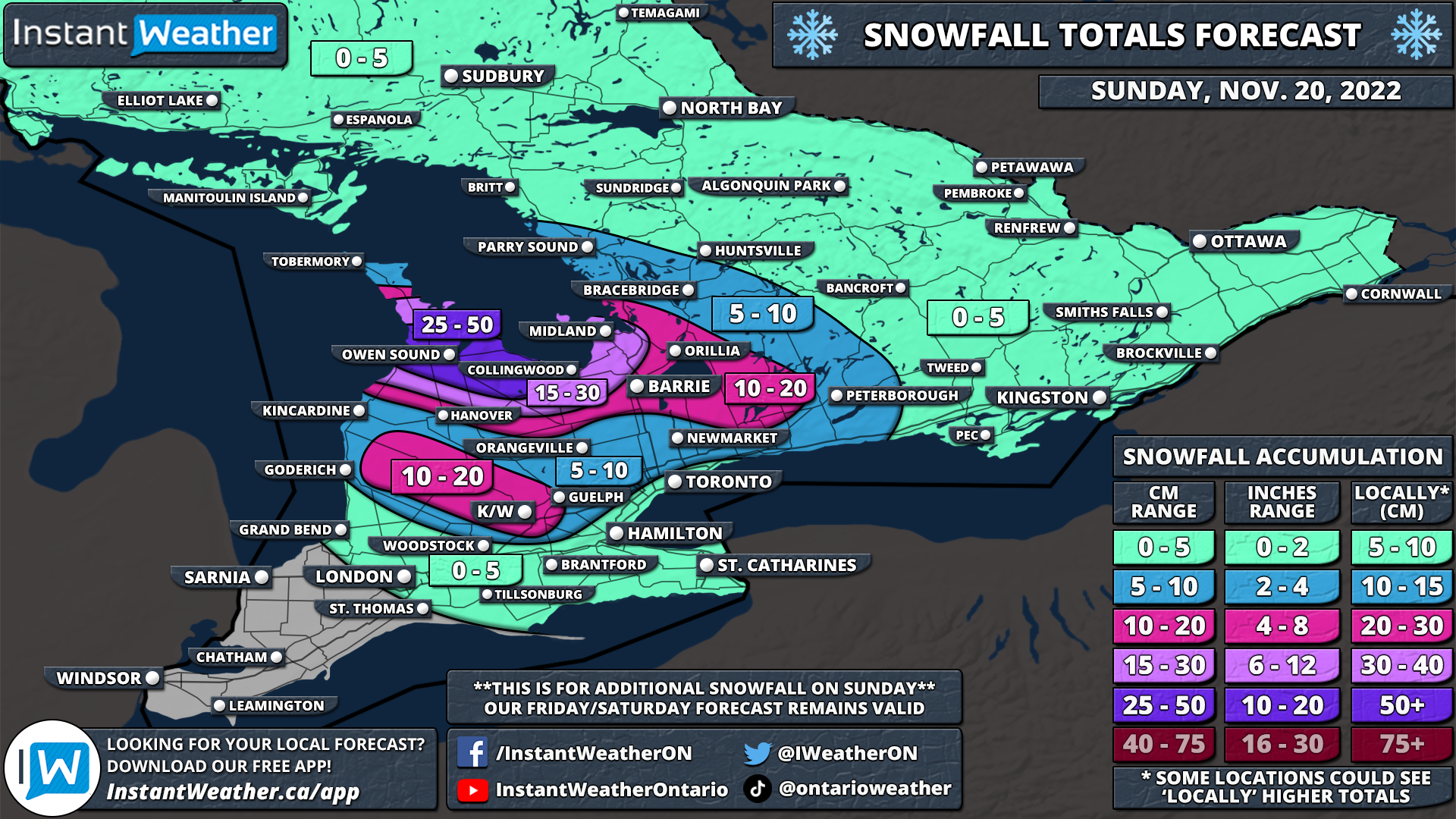
This arrival of cold air combined with the still relatively warm waters of the Great Lakes will allow for the development of lake effect snow off Lake Huron and Georgian Bay. Current indications suggest that we should see a band develop off Lake Huron and Georgian Bay with a primarily northwesterly flow starting Saturday evening. This would put the target zone around the Goderich and Stratford regions off Lake Huron along with the Barrie and Wasaga Beach regions off Georgian Bay. These areas could see locally significant snowfall totals ranging from up to 10-20cm by the end of the weekend.

There is still some uncertainty and the exact locations affected could change so we don’t have a forecast map for this event yet. We will provide a more detailed forecast by Saturday afternoon which will include expected accumulation. Lake effect snow is expected to linger throughout the day on Sunday before finally tapering off by late evening. While the accumulation will be contained to the aforementioned regions, the potential for scattered lake effect flurries will be quite expansive including the Golden Horseshoe and parts of Southwestern Ontario.

Here is another advertisement so we can pay other bills:


Weekend Winter Storm To Bring Heavy Snow, Prolonged Freezing Rain or Significant Rainfall to Northern Ontario

NOTE: You can click on the map to open a zoomable image which will be easier to read.

We are monitoring a system set to affect Northern Ontario this weekend which will bring a mixed bag of precipitation to the region depending on your location. Impacts will vary from heavy snow to the northwest of Thunder Bay, prolonged freezing rain through the Geraldton area and heavy rainfall for Northeastern Ontario. This will all begin tonight as an approaching system starts to spread rain across southern parts of Northeastern Ontario along the Lake Superior shoreline

Moisture will continue to be pumped into Northern Ontario throughout the overnight hours as precipitation slowly spreads to the northwest. By Saturday afternoon, the outer bands of the precipitation will encounter colder air resulting in an area of mixed precipitation developing somewhere from Marathon through Moosonee. It will start out as some ice pellets or light snow before a more potent band of freezing rain will set up around the Geraldton area by late Saturday. Further west, the predominant precipitation type will be sleet and heavy snow affecting locations such as Thunder Bay and Armstrong. Precipitation will linger overnight although it will slowly taper off by Sunday morning as the system moves out of the region.

In terms of impact, those in Northeastern Ontario including Sault Ste. Marie, Elliot Lake, Sudbury and Timmins will stay on the warm side of this winter storm and see all rain with total accumulation ranging from 30-60mm by Sunday morning. For the Marathon and Moosonee areas, you will start off with some mixed precipitation for a few hours during the late afternoon and early evening on Saturday before switching over to regular rain. The biggest impact will be around Geraldton with the potential for up to 4-8mm of ice accretion from freezing rain along with some mixed precipitation. Icy road conditions and power outages are possible in this region.

Accumulating snow is possible for parts of Northwestern Ontario with Thunder Bay picking up between a trace to 5cm of snow plus ice pellets. The heaviest snow will be found to the north for the Armstrong and Fort Hope region which could see up to 10-20cm of snow from this storm by Sunday. In addition to this, there will be strong wind gusts late Saturday with gusts approaching 70-90km/h mainly for regions to the north of Georgian Bay.

Here is another advertisement so we can pay other bills:


Possible Fall Wind Storm on Saturday Across Southern Ontario With Gusts Up to 95km/h and the Risk of Thunderstorms

NOTE: You can click on the map to open a zoomable image which will be easier to read.

It has been a strange start to November across Southern Ontario which is about to continue into the first weekend of this month. The weather story of the month so far has been the spooky fog that has set in since Halloween night. Most areas have seen the fog burn off throughout the day on Friday and current data indicates that it should stay that way. It’s possible we see some isolated fog patches overnight into Saturday morning especially near the shorelines as the fog blows in off the lakes, but it won’t be as thick or widespread as we have seen the last few nights.

The retreat of the fog will allow many areas to finally take full advantage of daylight heating from the sun bringing temperatures well into the double digits and potentially even low 20s for some locations. As we are already into November, these temperatures could come close to breaking records this weekend. These unseasonably warm temperatures are expected to continue on Sunday and Monday with daytime highs hitting double digits, but won’t be as warm as Saturday.

However, there is a catch with this warm weather as we are expecting some rain to slide into Southern Ontario by late Saturday and continue into early Sunday. It won’t be particularly heavy with total accumulation ranging from 5-10mm for Southern Ontario. Heavier rain will be found throughout Northeastern Ontario where totals could range from 30-60mm and as a result, Environment Canada has issued a rainfall warning for the affected regions.

The bigger threat this weekend will be the potential wind storm across Southern Ontario bringing gusts of up to 80-95km/h starting Saturday afternoon and lasting into early Sunday. Current data suggest that the strongest wind gusts will be found along the Lake Huron and Georgian Bay shoreline with maximum gusts of 85-95km/h. This could lead to some minor wind damage and even some sporadic power outages. The rest of Southern Ontario will see wind gusts ranging from 70-90km/h.

Something also quite rare for November may occur this weekend which is the risk of an isolated thunderstorm as a line of heavy rain sweeps across the region late Saturday and into the overnight hours. As a result, some locations may experience slightly higher wind gusts within the thunderstorms compared to what we’re forecasting. We can’t rule out an isolated 100+km/h wind gust somewhere in Southwestern Ontario.

The good news is that the active weather is expected to clear out quite fast. We should see the rain and wind come to an end early Sunday morning with another nice day ahead. Looking towards the next week, we expect to see a cool down by the middle of the week with overnight lows dipping to near the freezing mark, but there isn’t much precipitation in the near future.

Here is another advertisement so we can pay other bills:


The Battle of the Seasons With Accumulating Snow and Temperatures Near 20°C in the Coming Days for Southern Ontario

NOTE: You can click on the map to open a zoomable image which will be easier to read.

After we had a relatively mild start to fall, the past week or so has been dominated by a taste of wintery weather. Over the last few days, we’ve seen near-freezing temperatures and the first snowfall of the season in some parts of Southern Ontario. If you weren’t quite ready for this blast of wintery weather, you won’t like what is ahead for the next 24 hours with more snow and chilly temperatures. The good news is that there is light at the end of the tunnel as we see the return of milder air in time for the weekend.

Precipitation aided by lake enhancement off Lake Huron and Georgian Bay continues to linger across Southern Ontario on Wednesday. With temperatures expected to slide close to the freezing mark overnight, the precipitation will transition over to some light to moderate snow. This will be especially the case in the higher elevations of the Dundalk Highlands and into northern parts of Muskoka where even some accumulation is possible. Wet snow will continue into Thursday morning with the heaviest snow located east of Georgian Bay as a somewhat intense band of lake effect snow sets up over the Huntsville area. Reduced visibility and slushy roads will result in poor driving conditions throughout the affected region so be sure to take your time if you have to travel in the morning.

In terms of accumulation, this is very tricky to forecast as temperatures will be right near the freezing mark. Some of the models we review to create our forecast are showing significant totals of up to 15-20cm for parts of Muskoka by the end of Thursday. However, this isn’t realistic as it doesn’t account for most of the snow melting on contact as it falls onto the ground. We are going with a maximum of 4-8cm for total accumulation, but it’s important to note that this could be an underestimate if temperatures are slightly colder than expected.

Outside of that localized region, those who see snow over the next day will experience very little accumulation if anything at all. There could be a few centimetres of accumulation in parts of the Dundalk Highlands including Hanover, Shelburne and the Blue Mountains. The snow will come to an end by the afternoon on Thursday as temperatures slowly warm up and the snow transitions over to rain. Another night of near-freezing temperatures is expected as we go into Friday morning, but the lake-effect precipitation will have tapered off so we shouldn’t see any snow.

NOTE: You can click on the map to open a zoomable image which will be easier to read.

As our focus turns towards the weekend, we are watching what will be a radical change in our weather with the arrival of milder air which will push the temperatures into the double digits on Friday with even more of a warm-up on the weekend. If you have any activities you wanted to get done before winter comes then this weekend would be the perfect time to get them done.

Both Saturday and Sunday will feature well above seasonal temperatures pushing into the 20s which is quite uncommon this late in the season along with sunny skies. Even if you can’t get out and enjoy the weather this weekend, it will be sticking around for at least a few more days into early next week. It looks like more seasonal temperatures will return by the end of next week.

Here is another advertisement so we can pay other bills:


First Multi-Day Winter Storm of the Season Could Bring Up to 20-30cm of Snow to Parts of Northeastern Ontario Starting Monday

NOTE: You can click on the map to open a zoomable image which will be easier to read.

Mother Nature isn’t wasting any time with giving a taste of wintery weather this week across parts of Northern Ontario. The calendar might still say October, but the next few days will feel like we skipped a whole month right into late November. While most parts of Northern Ontario have already seen the season's first flakes, we are watching a multi-day system that could bring accumulating snowfall to a wide swath of Northeastern Ontario. The snow will start for some on Monday and continue on and off with multiple waves over through Tuesday and into Wednesday with total accumulation over the three days adding up to 20-30cm in the hardest hit areas.

A low-pressure system is expected to stall over the Great Lakes starting Monday which will provide a steady stream of precipitation across Northern and Southern Ontario over the next few days. In addition to the multiple waves of precipitation, some colder air will flow in from the west starting Monday dropping temperatures to near or slightly below the freezing mark through Northern Ontario. With temperatures near the freezing mark, it is likely that precipitation will come down in the form of wet snow for the Kapuskasing and Chapleau region starting as early as Monday afternoon.

It’s important to note that this is very temperature dependent which will affect exactly how much snow a particular region receives on the ground. The precipitation may also change back to a rain/snow mix during the day on Tuesday as temperatures warm up slightly before going back below the freezing mark. Not to mention that the ground is still fairly warm so it may take some time before the snow starts accumulating and thus reducing actual accumulation. So this forecast isn’t saying that a particular location will have 20-30cm of snow on the ground by Wednesday, but rather that total snowfall over the three days will add up to that and it’s hard to say exactly how much will melt.

Snow will come in multiple waves with the heaviest snow expected Tuesday afternoon and lingering into Wednesday morning. The snow should taper off by the middle of the day on Wednesday, but scattered flurries may continue into Thursday. Those closer to the Quebec border and up around James Bay will see slightly warmer temperatures so precipitation will come in the form of rain for the most part. However, a few hours of heavy snow is possible late Tuesday into Wednesday as the colder air finally spreads further east.

As this system extends multiple days, it’s possible that the forecast may change as we get closer and see how the first part of the precipitation develops. We will be monitoring the latest data and updating our forecast with a more precise expected snowfall accumulation map by Monday. As we’ve mentioned throughout the forecast, the confidence in this event is low as is typical with the season’s first major snowfall. So be aware that changes are likely with our final forecast.

Here is another advertisement so we can pay other bills:


Chilly Start to Thanksgiving Weekend With Potentially the First Flurries of the Season Overnight Friday in Parts of Southern Ontario

NOTE: You can click on the map to open a zoomable image which will be easier to read.

So far we’ve seen a fairly mild start to October across Southern Ontario with daytime temperatures well into the twenties for multiple days in a row this week. But don’t be fooled, winter is just around the corner and that reality will quickly set in over the next 24 hours as a cold front sweeps across the region. This will usher in much colder air into Southern Ontario with daytime highs in the mid to upper single digits on Friday. Lake effect showers will also be ongoing around Georgian Bay and Lake Huron throughout the day on Friday. Around 5-15mm of rainfall is expected for those southeasts of the lakes including Sarnia, Grand Bend, Collingwood and Barrie.

As we head into Friday night, the temperature is expected to further drop and come close to the freezing mark in some locations. Particularly the higher elevations of the Dundalk Highlands (Orangeville, Shelburne etc.), Northern Muskoka and Haliburton Highlands will see temperatures near or slightly below the freezing mark. As a result, there is a chance that the lingering lake effect showers throughout the region could come down in the form of wet flurries overnight Friday into Saturday morning. This includes parts of Huron and Grey-Bruce counties away from the shoreline, Hanover, Meaford, Blue Moutain, Shelburne and Orangeville overnight. And the chance will shift towards the Muskoka, Haliburton and Bancroft regions in the morning as the bands of lake effect precipitation move to the north.

It’s important to emphasize that this forecast is very preliminary and confidence is low since it really depends on the exact air temperature. Not everyone within our forecast will see the first snow of the season. And even if we do see snow, it will likely melt on contact and be gone by sunrise so unless you wake up early in the morning, you won’t even know that it snowed.

NOTE: You can click on the map to open a zoomable image which will be easier to read.

Despite the chilly (and potentially snowy) start to the Thanksgiving Weekend, we are expecting fairly decent weather for your Thanksgiving gatherings on Sunday. Temperatures during the day will range from the lower to mid-teens across Southern Ontario. Some rain will move through Central and Eastern Ontario during the early morning hours, but it should be done by the early afternoon. The rest of Southern Ontario will see a mix of sun and clouds for your Thanksgiving Sunday so maybe consider outdoor gatherings and take advantage of that fresh fall air!

For those that celebrate on Monday, the forecast will be basically a carbon copy of what we see on Sunday with temperatures slightly warmer and fewer clouds. On behalf of the entire Instant Weather team, we’d like to wish you a Happy Thanksgiving! We are incredibly grateful for your support throughout these years as we try to bring more context to the weather.

Here is another advertisement so we can pay other bills:


What The F...lurries? First Widespread Snowfall of the Season Starting Tonight Into Friday Morning Across Northeastern Ontario

NOTE: You can click on the map to open a zoomable image which will be easier to read.

It might still be a few weeks away from Halloween, but our forecast for this Thanksgiving Weekend is downright scary for those not ready for a taste of winter weather. Yes, it’s that time of the year when we must say the dreaded f-word for the first time! Parts of Northeastern Ontario are set to see the first flakes of the season starting Thursday evening and continuing into early Friday morning. Current indications suggest that the snow could come down heavy enough to lead to minor accumulation and as a result, some locations might be surprised with up to a few centimetres of that wet fluffy stuff on the ground as you wake up Friday morning.

The potential for wet snow will begin early this (Thursday) evening as a sharp cold front cuts across Northeastern Ontario. This will allow for temperatures to drop near the freezing mark over the next few hours causing the ongoing rainfall to slowly transition over to wet snow by tonight. Persistent light to moderate snowfall will continue overnight for locations such as Chapleau, Timmins, Cochrane and Englehart.

Depending on how cold the temperature can get and the intensity of the snowfall, some of these locations may wake up to some accumulation, but it will quickly melt as temperatures warm above the freezing mark after sunrise. Further to the southeast through the Elliot Lake, Sudbury and North Bay regions, they could also see some flurries overnight and early Friday morning, but the air temperature is still expected to remain slightly above the freezing mark which means any snow will melt on contact.

Heading into the Thanksgiving Weekend, it looks like the cold air will be sticking around at least for the next few days. Overnight lows will continue to flirt with the freezing mark all weekend. This also means that there is the chance for more wet flurries, although it appears that most of the activity will be continued to Far Northern Ontario like Fort Severn, Winisk and Attawapiskat. We should see somewhat of a warm-up by Monday/Tuesday with the potential for double-digit highs for some parts of Northern Ontario.

Here is another advertisement so we can pay other bills:


Autumn Sets In Across Ontario With a Significant Cooldown & the First Snowfall of the Season

NOTE: You can click on the map to open a zoomable image which will be easier to read.

As we head deep into the fall season with the arrival of October, it’s expected to see some colder air and even the risk of the familiar white flakes we haven’t seen in a while. For most, it still comes as a shock especially considering how warm the start of fall has been across the region. The rude awakening will occur later this week as a cold front ushes in colder temperatures across Northern and Southern Ontario. You still have time to get out there and enjoy the nice fall weather - double-digit daytime highs are expected to continue on Wednesday for all of Ontario and Thursday for Southern Ontario.

We will see the colder air making its way into Northwestern Ontario by late Wednesday as the cold front moves through. The cold front will also be accompanied by some light precipitation, initially coming down as rain showers. However, with temperatures expected to drop to near the freezing mark overnight Wednesday into Thursday morning, it could transition over to some wet snow. This is predominantly for Northwestern Ontario along the Manitoba border where the temperatures will be cold enough for snow. We don’t expect much in terms of accumulation since the ground will still be fairly warm and any snow will melt on contact.

NOTE: You can click on the map to open a zoomable image which will be easier to read.

The cold front will continue to progress to the southeast throughout the day on Thursday. This will bring the risk of some wet snow to parts of Northeastern Ontario overnight Thursday as temperatures hover near the freezing mark. There is some indication that the snow could be quite heavy at times so it may leave some minor accumulation through Chapleau and Timmins with up to 2-4cm possible. However, this is questionable so it’s not guaranteed to accumulate and will come down to exactly how cold it can get.

NOTE: You can click on the map to open a zoomable image which will be easier to read.

For Southern Ontario, the story for most of the week will be almost perfect fall weather with mild temperatures in the high teens or low twenties and not much in terms of rain. By Friday this will change with the arrival of the cold front early Friday which will result in a rapid drop in temperatures. The daytime high on Friday will be around 10 degrees colder than just 24 hours earlier! It will get even colder overnight into Saturday morning with many areas at or slightly below the freezing mark leading to the widespread risk of frost.

It appears that Southern Ontario should avoid the season’s first snowfall for the most part. There still could be some flurries early in the morning on Friday through North Bay and into Algonquin Park, but it shouldn’t be widespread. Temperatures will moderate somewhat heading into next week which should ensure we don’t get any snow just yet. It’s only a matter of time though and it does look colder towards the middle and end of October so there might be a chance for many areas to see their first flakes of the season.

Here is another advertisement so we can pay other bills: