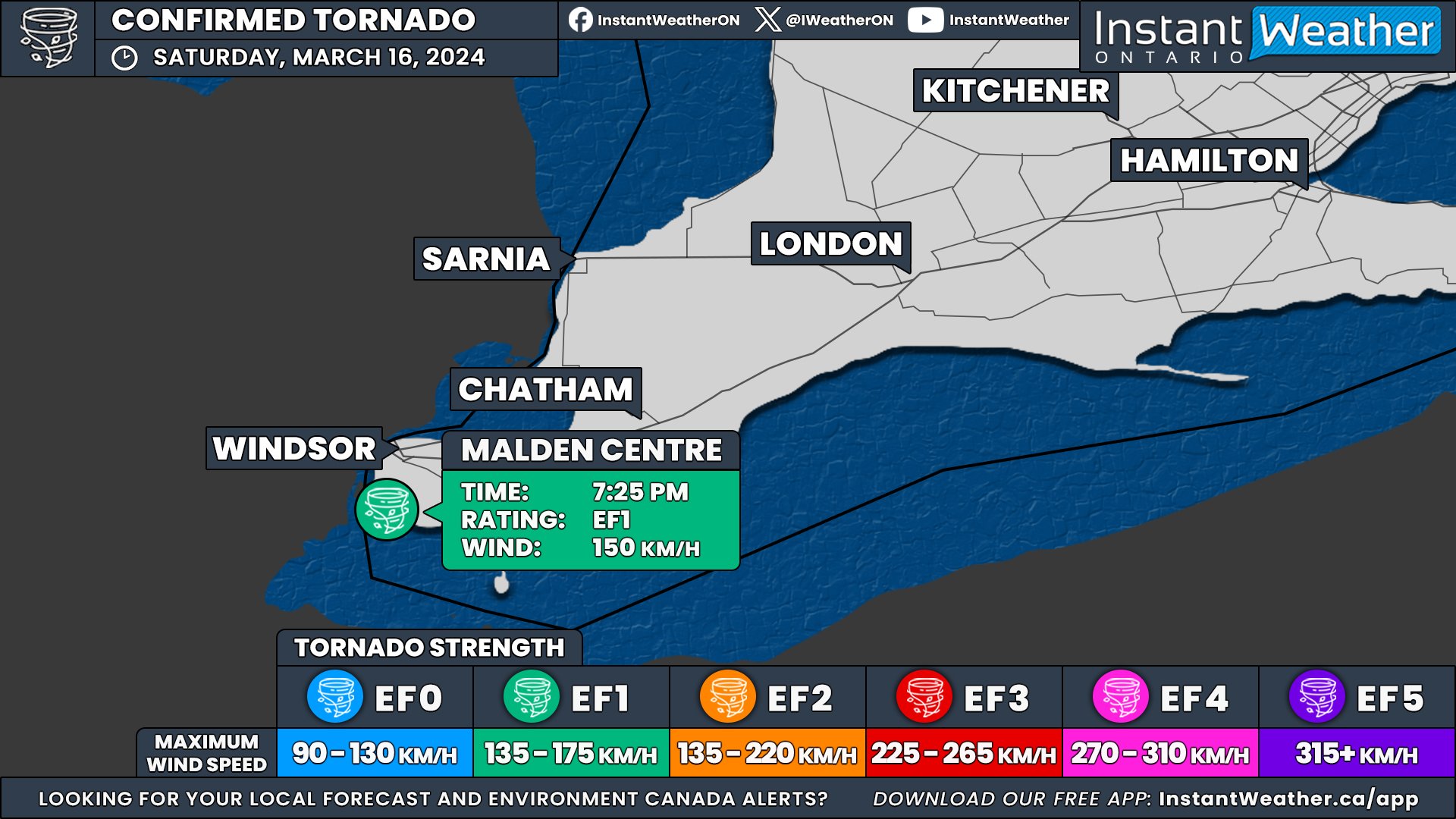
First Tornado of 2024 Confirmed in Ontario on March 16th; Ties With Earliest Tornado on Record

NOTE: YOU CAN CLICK ON THE MAP TO OPEN A ZOOMABLE IMAGE

In an unusually early start to the tornado season, Ontario recorded its first confirmed tornado of the year on March 16th. This event ties with the record for the earliest tornado occurrence in the province, a record previously set in 2016 in Clifford, Ontario.


GOOGLE AD (NOT ENDORSED BY INSTANT WEATHER)

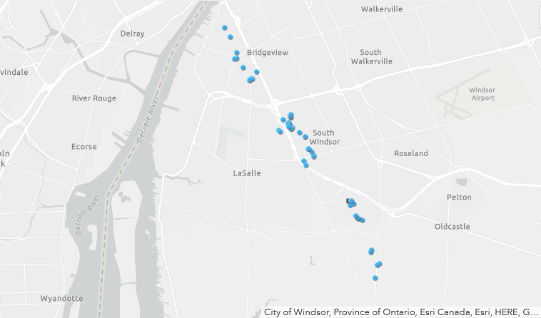
Map showing the tornado track just south of Malden Centre, and points where damage was documented.

SOURCE: NORTHERN TORNADOES PROJECT

The Northern Tornadoes Project (NTP) confirmed the tornado following a comprehensive damage survey in the Malden Centre area, south of Windsor, where significant damage was reported.


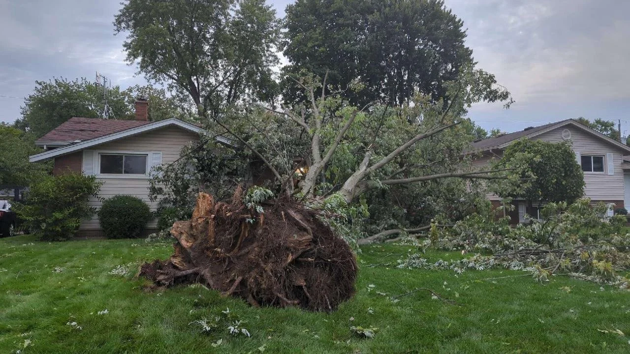
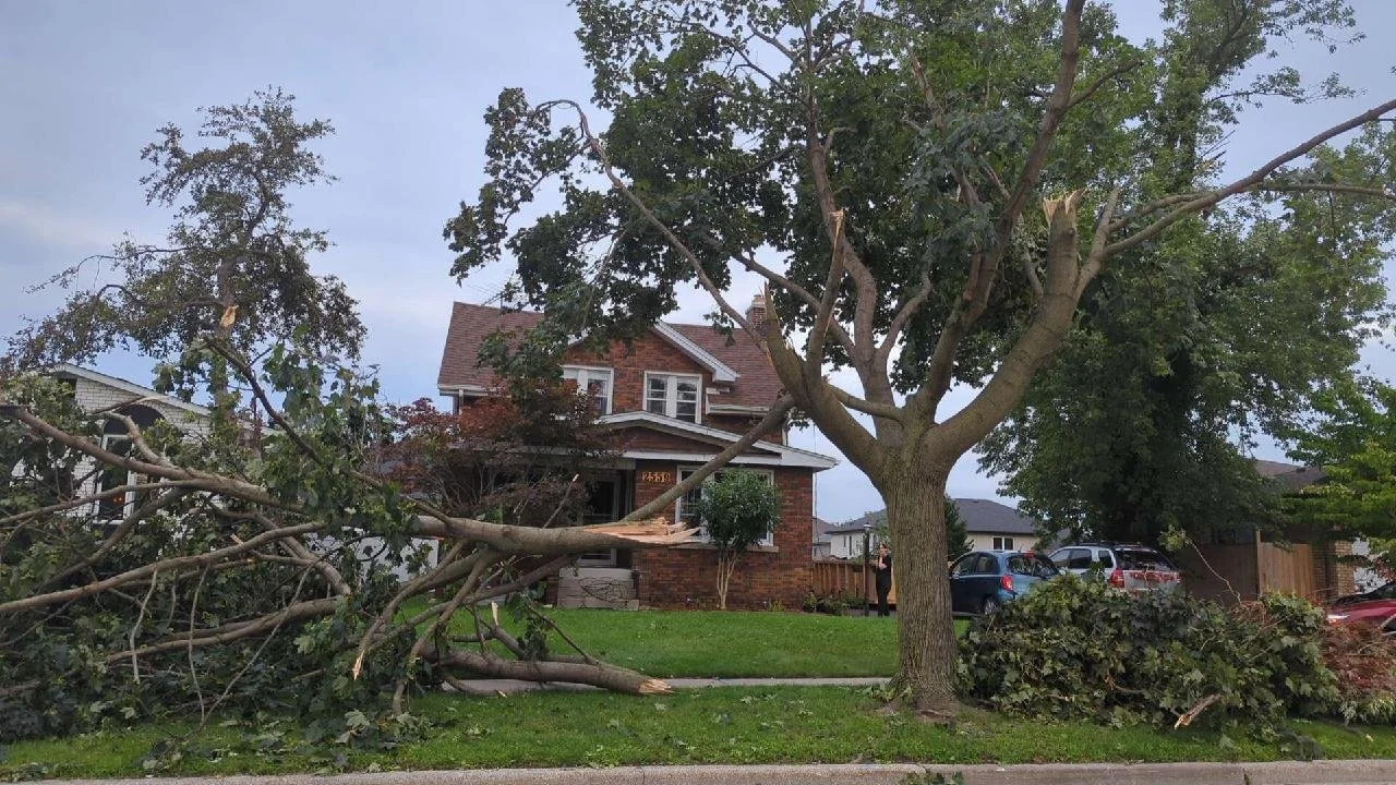
Roof debris downwind, and roof of second double-wide mobile home with half of its roof off.

SOURCE: Kevin Sprague / NORTHERN TORNADOES PROJECT

Rated as an EF1 on the Enhanced Fujita Scale, the tornado reached maximum wind speeds of about 150 km/h. The most significant damage was noted where a double-wide mobile home had its roof completely removed. Other damages included shingle destruction, a downed tree at another residence, and extensive damage to trees in surrounding woodlands.


GOOGLE AD (NOT ENDORSED BY INSTANT WEATHER)

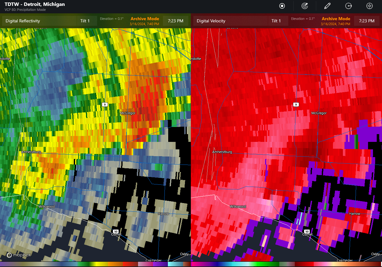
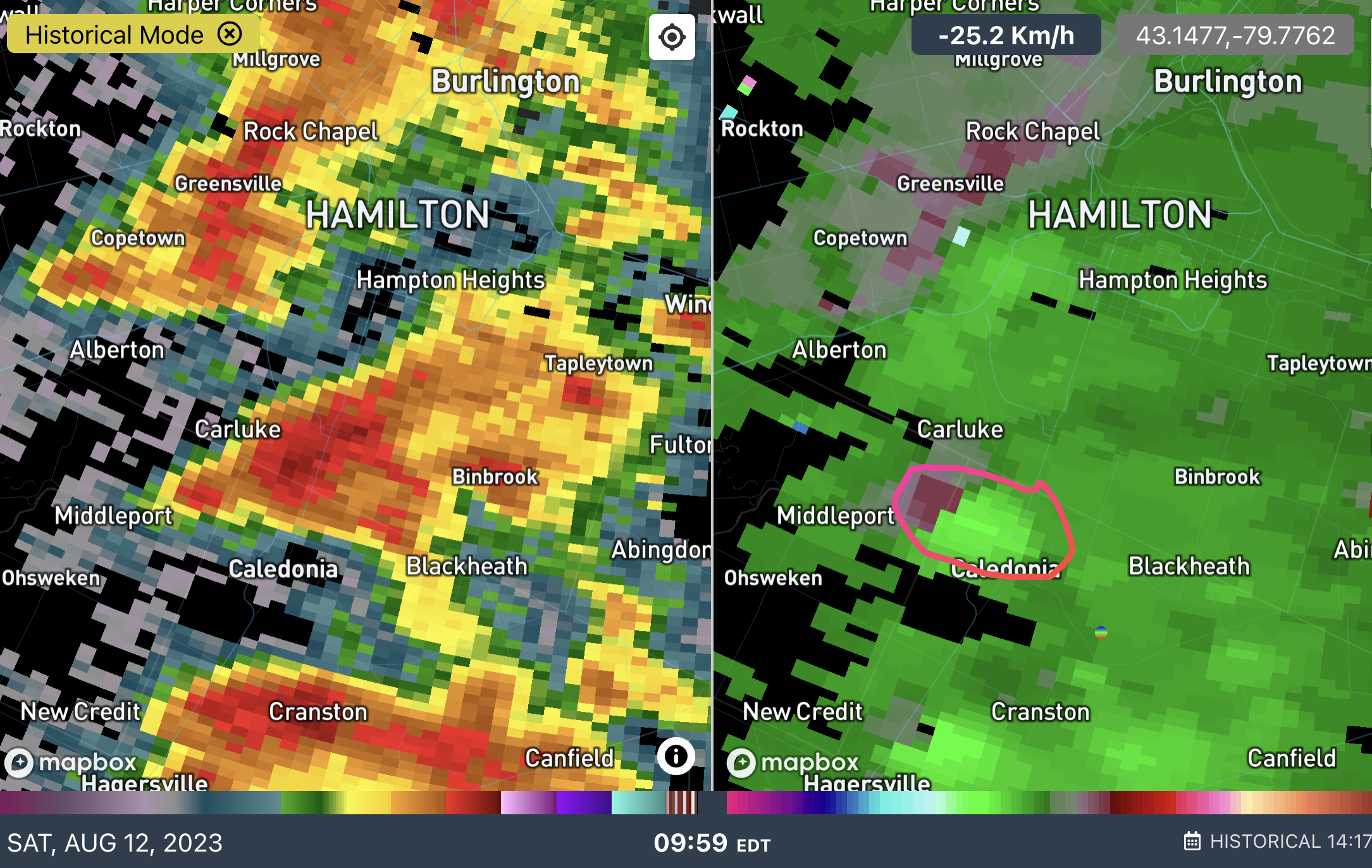
TDTW radar at 7:23 pm EDT showing main storm near Essex producing severe hail (left image), and gust front trailing back to the southwest with embedded area of rotation right over the location with the roof removed (lower middle of image at right). The rotation is apparent only in the two lowest tilts (second tilt not shown).

SOURCE: NORTHERN TORNADOES PROJECT

Classified as a QLCS (Quasi-Linear Convective System) tornado, it developed along the leading edge of a thunderstorm's outflow. Radar data from Detroit Metro Airport clearly showed a tight rotation at the exact locations of the reported damages. There were no preceding tornado warnings and no reports of severe weather from nearby Michigan, although the storm did produce severe hail in parts of Ontario.

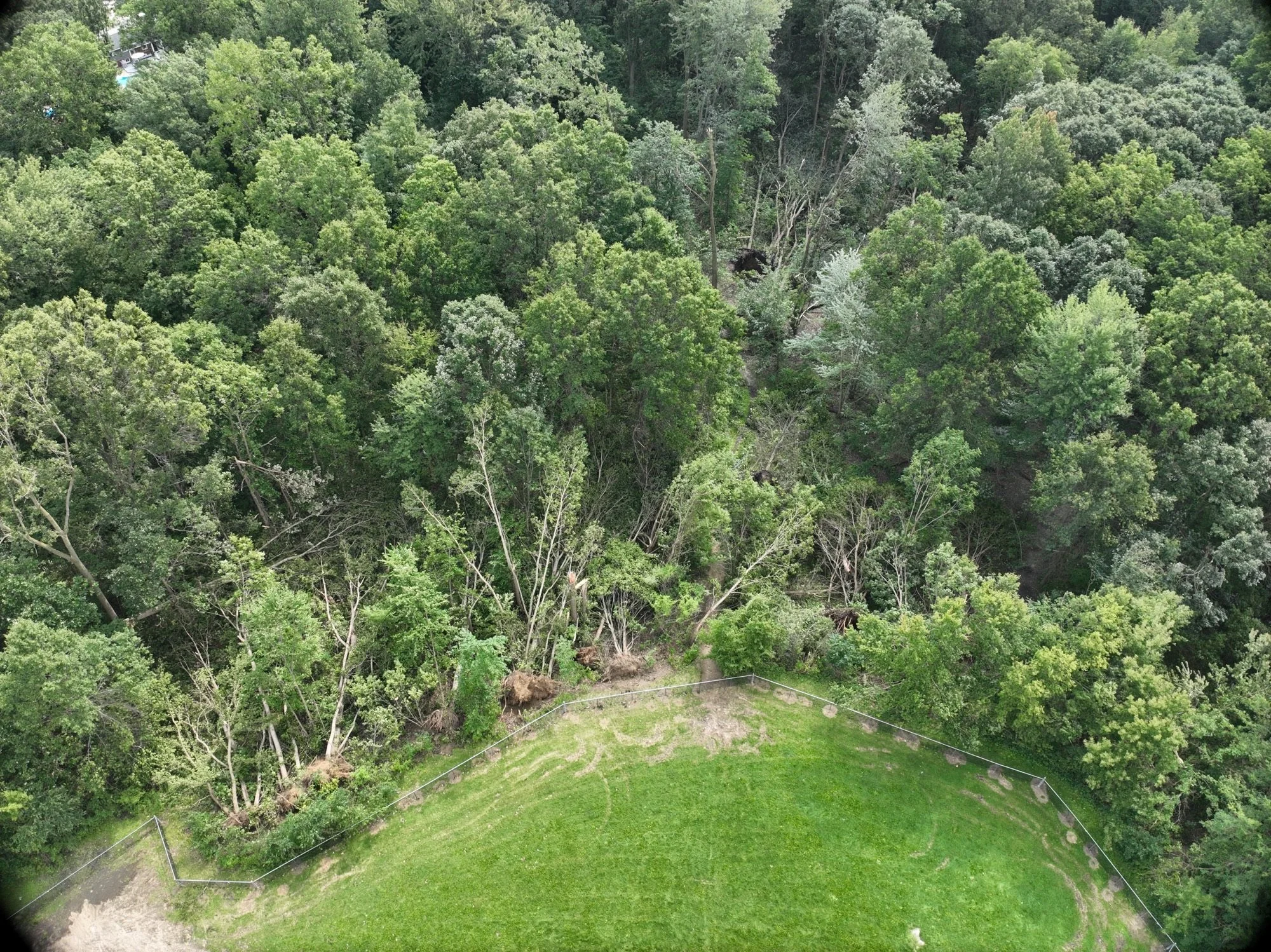
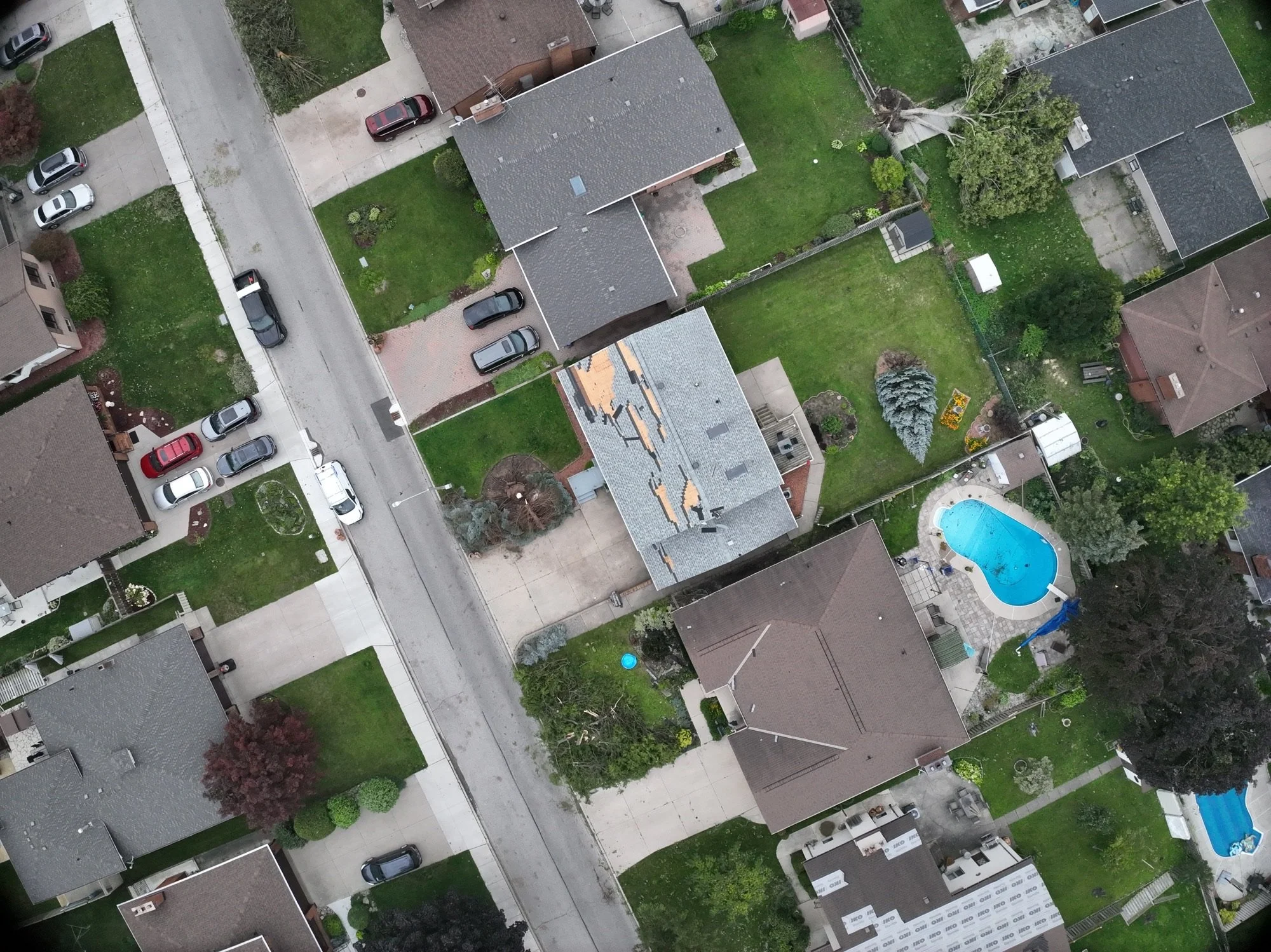
Drone image showing trees down to the ESE along the path of the tornado (circled).

SOURCE: NORTHERN TORNADOES PROJECT

The tornado's path was approximately 1.10 kilometres long and reached a maximum width of 100 meters. The damage to trees was presumably less severe than it might have been if the trees had been in leaf, which could have resulted in more extensive damage.


GOOGLE AD (NOT ENDORSED BY INSTANT WEATHER)

The Countdown is On! One Week Until Solar Eclipse in Ontario

NOTE: YOU CAN CLICK ON THE MAP TO OPEN A ZOOMABLE IMAGE


Ontario is in for a rare celestial display of a solar eclipse on Monday, April 8, 2024. The entire province will be able to witness this, and small stretch of Southern Ontario will be treated to a very brief total solar eclipse with a “ring of fire” as the Moon moves across and obscures the Sun.

Here's what you need to know about this event and how to observe it safely.


GOOGLE AD (NOT ENDORSED BY INSTANT WEATHER)

Timing and Coverage

Residents across Northern Ontario will see at least 50% of total sun coverage, with the Northwestern edge of the province seeing the least and coverage gradually increases moving south and east to just under 90% once reaching Southern Ontario.

This will be a spectacular partial eclipse for Northern Ontario, but Southern Ontario is in for a real treat. The whole region will see more than 90% of the Sun covered by the Moon. However, along most the northern shores of Lake Erie and Lake Ontario, as well as in the Niagara Region, up into the northern edges of both Norfolk and Haldimand Counties, into the southern extent of Brant County to Hamilton and even around Burlington Bay to include the City of Burlington, residents and visitors will be able to witness a full solar eclipse for a couple short minutes.

Unfortunately, the most heavily populated area of the Lake Ontario lakeshore, from Oakville across the City of Toronto to Bowmanville, will be just outside of the path of totality.

Solar Eclipse Timing Across Southern Ontario

   
Location   
   
Max Coverage   
   
Partial Begins   
   
Totality Begins   
   
Maximum   
   
Totality Ends   
   
Partial Ends   
   
Bancroft   
   
97.69%   
   
2:08 PM   
   
-   
   
3:22 PM   
   
-   
   
4:33 PM   
   
Barrie   
   
97.61%   
   
2:05 PM   
   
-   
   
3:19 PM   
   
-   
   
4:31 PM   
   
Cornwall   
   
100%   
   
2:12 PM   
   
3:24 PM   
   
3:26 PM   
   
3:27 PM   
   
4:35 PM   
   
Hamilton   
   
100%   
   
2:03 PM   
   
3:18 PM   
   
3:19 PM   
   
3:20 PM   
   
4:31 PM   
   
Huntsville   
   
95.09%   
   
2:06 PM   
   
-   
   
3:20 PM   
   
-   
   
4:31 PM   
   
Kingston   
   
100%   
   
2:09 PM   
   
3:22 PM   
   
3:23 PM   
   
3:25 PM   
   
4:34 PM   
   
Kitchener-Waterloo   
   
99.42%   
   
2:03 PM   
   
-   
   
3:18 PM   
   
-   
   
4:30 PM   
   
London   
   
99.76%   
   
2:01 PM   
   
-   
   
3:17 PM   
   
-   
   
4:29 PM   
   
Niagara Falls   
   
100%   
   
2:04 PM   
   
3:18 PM   
   
3:20 PM   
   
3:21 PM   
   
4:31 PM   
   
North Bay   
   
91.28%   
   
2:07 PM   
   
-   
   
3:20 PM   
   
-   
   
4:31 PM   
   
Oshawa   
   
99.82%   
   
2:05 PM   
   
-   
   
3:20 PM   
   
-   
   
4:32 PM   
   
Ottawa   
   
98.85%   
   
2:11 PM   
   
-   
   
3:25 PM   
   
-   
   
4:35 PM   
   
Peterborough   
   
99.45%   
   
2:07 PM   
   
-   
   
3:21 PM   
   
-   
   
4:32 PM   
   
Squirrel Depot   
   
95.31%   
   
2:09 PM   
   
-   
   
3:23 PM   
   
-   
   
4:33 PM   
   
Toronto   
   
99.92%   
   
2:04 PM   
   
-   
   
3:19 PM   
   
-   
   
4:31 PM   
   
Windsor   
   
99.54%   
   
1:58 PM   
   
-   
   
3:14 PM   
   
-   
   
4:27 PM   

GOOGLE AD (NOT ENDORSED BY INSTANT WEATHER)

Solar Eclipse Timing Across Northern Ontario


Location
   
Max Coverage   
   
Partial Begins   
   
Maximum   
   
Partial Ends   
   
Armstrong   
   
64.58%   
   
2:02 PM EDT   
   
3:11 PM EDT   
   
4:19 PM EDT   
   
Atikokan   
   
65.40%   
   
12:57 PM CDT   
   
2:07 PM CDT   
   
3:16 PM CDT   
   
Chapleau   
   
80.57%   
   
2:04 PM EDT   
   
3:16 PM EDT   
   
4:26 PM EDT   
   
Cochrane   
   
79.55%   
   
2:08 PM EDT   
   
3:19 PM EDT   
   
4:28 PM EDT   
   
Dryden   
   
60.55%   
   
12:58 PM CDT   
   
2:06 PM CDT   
   
3:14 PM CDT   
   
Elliot Lake   
   
86.68%   
   
2:03 PM EDT   
   
3:17 PM EDT   
   
4:27 PM EDT   
   
Espanola   
   
88.35%   
   
2:04 PM EDT   
   
3:18 PM EDT   
   
4:28 PM EDT   
   
Fort Frances   
   
63.05%   
   
12:55 PM CDT   
   
2:05 PM CDT   
   
3:14 PM CDT   
   
Fort Hope   
   
62.26%   
   
2:05 PM EDT   
   
3:13 PM EDT   
   
4:19 PM EDT   
   
Geraldton   
   
69.34%   
   
2:03 PM EDT   
   
3:13 PM EDT   
   
4:21 PM EDT   
   
Hearst   
   
73.99%   
   
2:06 PM EDT   
   
3:17 PM EDT   
   
4:25 PM EDT   
   
Kapuskasing   
   
76.52%   
   
2:07 PM EDT   
   
3:18 PM EDT   
   
4:27 PM EDT   
   
Kenora   
   
58.08%   
   
12:56 PM CDT   
   
2:04 PM CDT   
   
3:12 PM CDT   
   
Kirkland Lake   
   
84.04%   
   
2:08 PM EDT   
   
3:20 PM EDT   
   
4:30 PM EDT   
   
Marathon   
   
73.39%   
   
2:02 PM EDT   
   
3:13 PM EDT   
   
4:22 PM EDT   
   
Red Lake   
   
55.61%   
   
12:59 PM CDT   
   
2:06 PM CDT   
   
3:12 PM CDT   
   
Sault Ste. Marie   
   
83.74%   
   
2:01 PM EDT   
   
3:15 PM EDT   
   
4:26 PM EDT   
   
Sudbury   
   
88.59%   
   
2:05 PM EDT   
   
3:19 PM EDT   
   
4:29 PM EDT   
   
Temiskaming Shores   
   
86.88%   
   
2:08 PM EDT   
   
3:21 PM EDT   
   
4:30 PM EDT   
   
Thunder Bay   
   
70.11%   
   
1:59 PM EDT   
   
3:10 PM EDT   
   
4:19 PM EDT   
   
Timmins   
   
81.20%   
   
2:07 PM EDT   
   
3:19 PM EDT   
   
4:28 PM EDT   
   
Wawa   
   
78.12%   
   
2:03 PM EDT   
   
3:15 PM EDT   
   
4:25 PM EDT   

For specific eclipse coverage and timing in your location, you can go to timeanddate.com to find detailed information.


GOOGLE AD (NOT ENDORSED BY INSTANT WEATHER)

Safety Measures

Safety is paramount when viewing any solar eclipse, even a partial one. To ensure a safe and memorable experience, follow these crucial precautions:

  • Solar Viewing Glasses: Never attempt to observe the eclipse with the naked eye. Only use certified solar viewing glasses or eclipse glasses with ISO 12312-2 certification, specifically designed to protect your eyes from the Sun's harmful radiation.

  • Pinhole Projection: If eclipse glasses are unavailable, create a pinhole projector using common materials like cardboard. This indirect method allows you to project the eclipse safely onto a surface for viewing.

  • Telescopes and Binoculars: If using telescopes or binoculars, ensure they are equipped with proper solar filters to safeguard your eyes. Never aim them directly at the Sun without these protective measures.

  • Online Streaming: For those unable to view the eclipse in person or seeking a risk-free option, numerous reputable sources will provide live streaming of the event.

  • Local Eclipse Events: Consider joining local astronomy clubs or observatories hosting eclipse-viewing gatherings. These events offer expert guidance and a shared sense of community.

Please note that cloud cover could affect the ability to see the eclipse. Cloud cover is historically 60-80% for early April so be prepared for variable weather conditions and have alternative viewing options available.

Partial and Total Solar Eclipse Will Be Visible Across Ontario on April 8th

NOTE: YOU CAN CLICK ON THE MAP TO OPEN A ZOOMABLE IMAGE


Ontario is in for a rare celestial display of a solar eclipse on Monday, April 8, 2024. The entire province will be able to witness this, and small stretch of Southern Ontario will be treated to a very brief total solar eclipse with a “ring of fire” as the Moon moves across and obscures the Sun.

Here's what you need to know about this event and how to observe it safely.


GOOGLE AD (NOT ENDORSED BY INSTANT WEATHER)

Timing and Coverage

Residents across Northern Ontario will see at least 50% of total sun coverage, with the Northwestern edge of the province seeing the least and coverage gradually increases moving south and east to just under 90% once reaching Southern Ontario.

This will be a spectacular partial eclipse for Northern Ontario, but Southern Ontario is in for a real treat. The whole region will see more than 90% of the Sun covered by the Moon. However, along most the northern shores of Lake Erie and Lake Ontario, as well as in the Niagara Region, up into the northern edges of both Norfolk and Haldimand Counties, into the southern extent of Brant County to Hamilton and even around Burlington Bay to include the City of Burlington, residents and visitors will be able to witness a full solar eclipse for a couple short minutes.

Unfortunately, the most heavily populated area of the Lake Ontario lakeshore, from Oakville across the City of Toronto to Bowmanville, will be just outside of the path of totality.

Solar Eclipse Timing Across Southern Ontario

   
Location   
   
Max Coverage   
   
Partial Begins   
   
Totality Begins   
   
Maximum   
   
Totality Ends   
   
Partial Ends   
   
Bancroft   
   
97.69%   
   
2:08 PM   
   
-   
   
3:22 PM   
   
-   
   
4:33 PM   
   
Barrie   
   
97.61%   
   
2:05 PM   
   
-   
   
3:19 PM   
   
-   
   
4:31 PM   
   
Cornwall   
   
100%   
   
2:12 PM   
   
3:24 PM   
   
3:26 PM   
   
3:27 PM   
   
4:35 PM   
   
Hamilton   
   
100%   
   
2:03 PM   
   
3:18 PM   
   
3:19 PM   
   
3:20 PM   
   
4:31 PM   
   
Huntsville   
   
95.09%   
   
2:06 PM   
   
-   
   
3:20 PM   
   
-   
   
4:31 PM   
   
Kingston   
   
100%   
   
2:09 PM   
   
3:22 PM   
   
3:23 PM   
   
3:25 PM   
   
4:34 PM   
   
Kitchener-Waterloo   
   
99.42%   
   
2:03 PM   
   
-   
   
3:18 PM   
   
-   
   
4:30 PM   
   
London   
   
99.76%   
   
2:01 PM   
   
-   
   
3:17 PM   
   
-   
   
4:29 PM   
   
Niagara Falls   
   
100%   
   
2:04 PM   
   
3:18 PM   
   
3:20 PM   
   
3:21 PM   
   
4:31 PM   
   
North Bay   
   
91.28%   
   
2:07 PM   
   
-   
   
3:20 PM   
   
-   
   
4:31 PM   
   
Oshawa   
   
99.82%   
   
2:05 PM   
   
-   
   
3:20 PM   
   
-   
   
4:32 PM   
   
Ottawa   
   
98.85%   
   
2:11 PM   
   
-   
   
3:25 PM   
   
-   
   
4:35 PM   
   
Peterborough   
   
99.45%   
   
2:07 PM   
   
-   
   
3:21 PM   
   
-   
   
4:32 PM   
   
Squirrel Depot   
   
95.31%   
   
2:09 PM   
   
-   
   
3:23 PM   
   
-   
   
4:33 PM   
   
Toronto   
   
99.92%   
   
2:04 PM   
   
-   
   
3:19 PM   
   
-   
   
4:31 PM   
   
Windsor   
   
99.54%   
   
1:58 PM   
   
-   
   
3:14 PM   
   
-   
   
4:27 PM   

GOOGLE AD (NOT ENDORSED BY INSTANT WEATHER)

Solar Eclipse Timing Across Northern Ontario


Location
   
Max Coverage   
   
Partial Begins   
   
Maximum   
   
Partial Ends   
   
Armstrong   
   
64.58%   
   
2:02 PM EDT   
   
3:11 PM EDT   
   
4:19 PM EDT   
   
Atikokan   
   
65.40%   
   
12:57 PM CDT   
   
2:07 PM CDT   
   
3:16 PM CDT   
   
Chapleau   
   
80.57%   
   
2:04 PM EDT   
   
3:16 PM EDT   
   
4:26 PM EDT   
   
Cochrane   
   
79.55%   
   
2:08 PM EDT   
   
3:19 PM EDT   
   
4:28 PM EDT   
   
Dryden   
   
60.55%   
   
12:58 PM CDT   
   
2:06 PM CDT   
   
3:14 PM CDT   
   
Elliot Lake   
   
86.68%   
   
2:03 PM EDT   
   
3:17 PM EDT   
   
4:27 PM EDT   
   
Espanola   
   
88.35%   
   
2:04 PM EDT   
   
3:18 PM EDT   
   
4:28 PM EDT   
   
Fort Frances   
   
63.05%   
   
12:55 PM CDT   
   
2:05 PM CDT   
   
3:14 PM CDT   
   
Fort Hope   
   
62.26%   
   
2:05 PM EDT   
   
3:13 PM EDT   
   
4:19 PM EDT   
   
Geraldton   
   
69.34%   
   
2:03 PM EDT   
   
3:13 PM EDT   
   
4:21 PM EDT   
   
Hearst   
   
73.99%   
   
2:06 PM EDT   
   
3:17 PM EDT   
   
4:25 PM EDT   
   
Kapuskasing   
   
76.52%   
   
2:07 PM EDT   
   
3:18 PM EDT   
   
4:27 PM EDT   
   
Kenora   
   
58.08%   
   
12:56 PM CDT   
   
2:04 PM CDT   
   
3:12 PM CDT   
   
Kirkland Lake   
   
84.04%   
   
2:08 PM EDT   
   
3:20 PM EDT   
   
4:30 PM EDT   
   
Marathon   
   
73.39%   
   
2:02 PM EDT   
   
3:13 PM EDT   
   
4:22 PM EDT   
   
Red Lake   
   
55.61%   
   
12:59 PM CDT   
   
2:06 PM CDT   
   
3:12 PM CDT   
   
Sault Ste. Marie   
   
83.74%   
   
2:01 PM EDT   
   
3:15 PM EDT   
   
4:26 PM EDT   
   
Sudbury   
   
88.59%   
   
2:05 PM EDT   
   
3:19 PM EDT   
   
4:29 PM EDT   
   
Temiskaming Shores   
   
86.88%   
   
2:08 PM EDT   
   
3:21 PM EDT   
   
4:30 PM EDT   
   
Thunder Bay   
   
70.11%   
   
1:59 PM EDT   
   
3:10 PM EDT   
   
4:19 PM EDT   
   
Timmins   
   
81.20%   
   
2:07 PM EDT   
   
3:19 PM EDT   
   
4:28 PM EDT   
   
Wawa   
   
78.12%   
   
2:03 PM EDT   
   
3:15 PM EDT   
   
4:25 PM EDT   

For specific eclipse coverage and timing in your location, you can go to timeanddate.com to find detailed information.


GOOGLE AD (NOT ENDORSED BY INSTANT WEATHER)

Safety Measures

Safety is paramount when viewing any solar eclipse, even a partial one. To ensure a safe and memorable experience, follow these crucial precautions:

  • Solar Viewing Glasses: Never attempt to observe the eclipse with the naked eye. Only use certified solar viewing glasses or eclipse glasses with ISO 12312-2 certification, specifically designed to protect your eyes from the Sun's harmful radiation.

  • Pinhole Projection: If eclipse glasses are unavailable, create a pinhole projector using common materials like cardboard. This indirect method allows you to project the eclipse safely onto a surface for viewing.

  • Telescopes and Binoculars: If using telescopes or binoculars, ensure they are equipped with proper solar filters to safeguard your eyes. Never aim them directly at the Sun without these protective measures.

  • Online Streaming: For those unable to view the eclipse in person or seeking a risk-free option, numerous reputable sources will provide live streaming of the event.

  • Local Eclipse Events: Consider joining local astronomy clubs or observatories hosting eclipse-viewing gatherings. These events offer expert guidance and a shared sense of community.

Please note that cloud cover could affect the ability to see the eclipse. Cloud cover is historically 60-80% for early April so be prepared for variable weather conditions and have alternative viewing options available.

Partial Solar Eclipse to Be Visible Across Ontario on Saturday

NOTE: YOU CAN CLICK ON THE MAP TO OPEN A ZOOMABLE IMAGE


GOOGLE AD (NOT ENDORSED BY INSTANT WEATHER)

Ontario is in for a celestial treat as we prepare to witness a partial view of the annular solar eclipse on Saturday, October 14, 2023. While not the full "ring of fire" experience seen in some parts of the world, this partial eclipse promises a captivating display of the Moon partially obscuring the Sun's disk.

This partial solar eclipse is an appetizer for our region as we look forward to a total solar eclipse that will be visible in parts of Southern Ontario on April 8, 2024. Which is less than 6 months away!

Here's what you need to know about this event and how to observe it safely.


GOOGLE AD (NOT ENDORSED BY INSTANT WEATHER)

NOTE: YOU CAN CLICK ON THE MAP TO OPEN A ZOOMABLE IMAGE


Timing and Coverage

On Saturday, residents across Ontario will be treated to a partial glimpse of the annular solar eclipse. Though not a total eclipse, it will still offer a unique astronomical spectacle. The degree of coverage will vary across the province ranging from just under 20% in the east and near 40% in the northwest.


GOOGLE AD (NOT ENDORSED BY INSTANT WEATHER)

Solar Eclipse Timing Across Ontario

Solar Eclipse Timing Across Ontario

Location Max Obscuration Start Max End
Barrie 26.4% 11:55 AM 1:08 PM 2:23 PM
Guelph 28.3% 11:53 AM 1:08 PM 2:25 PM
Hamilton 28.2% 11:54 AM 1:09 PM 2:26 PM
Kingston 22.3% 12:03 PM 1:14 PM 2:25 PM
Kitchener 28.8% 11:53 AM 1:08 PM 2:25 PM
London 30.6% 11:51 AM 1:07 PM 2:25 PM
Niagara Falls 27.3% 11:56 AM 1:10 PM 2:26 PM
North Bay 23.6% 11:57 AM 1:07 PM 2:19 PM
Ottawa 19.8% 12:06 PM 1:14 PM 2:23 PM
Peterborough 24.6% 11:58 AM 1:10 PM 2:24 PM
Sarnia 32.4% 11:48 AM 1:05 PM 2:24 PM
Sault Ste. Marie 29.9% 11:46 AM 12:59 PM 2:15 PM
Sudbury 25.4% 11:53 AM 1:04 PM 2:17 PM
Thunder Bay 33.9% 11:38 AM 12:52 PM 2:08 PM
Toronto 26.9% 11:55 AM 1:09 PM 2:25 PM
Windsor 34.5% 11:46 AM 1:05 PM 2:25 PM

For specific eclipse coverage and timing in your location, you can go to timeanddate.com to find detailed information.


GOOGLE AD (NOT ENDORSED BY INSTANT WEATHER)

Safety Measures

Safety is paramount when viewing any solar eclipse, even a partial one. To ensure a safe and memorable experience, follow these crucial precautions:

  • Solar Viewing Glasses: Never attempt to observe the eclipse with the naked eye. Only use certified solar viewing glasses or eclipse glasses with ISO 12312-2 certification, specifically designed to protect your eyes from the Sun's harmful radiation.

  • Pinhole Projection: If eclipse glasses are unavailable, create a pinhole projector using common materials like cardboard. This indirect method allows you to project the eclipse safely onto a surface for viewing.

  • Telescopes and Binoculars: If using telescopes or binoculars, ensure they are equipped with proper solar filters to safeguard your eyes. Never aim them directly at the Sun without these protective measures.

  • Online Streaming: For those unable to view the eclipse in person or seeking a risk-free option, numerous reputable sources will provide live streaming of the event.

  • Local Eclipse Events: Consider joining local astronomy clubs or observatories hosting eclipse-viewing gatherings. These events offer expert guidance and a shared sense of community.


GOOGLE AD (NOT ENDORSED BY INSTANT WEATHER)

GOOGLE AD (NOT ENDORSED BY INSTANT WEATHER)

Please note that cloud cover could affect the ability to see the eclipse. Be prepared for variable weather conditions and have alternative viewing options available. We will be closely tracking the forecast over the coming days and will have more updates on our social media pages.

As you anticipate the partial view of the annular solar eclipse on Saturday, remember to prioritize safety while immersing yourself in this celestial marvel. With proper precautions and a sense of awe, you can make the most of this extraordinary astronomical event.

Northern Lights Dazzle the Sky Over Southern Ontario on Monday Night; Will They Return Tonight?


GOOGLE AD (NOT ENDORSED BY INSTANT WEATHER)

Residents across Southern Ontario were treated to a rare and awe-inspiring celestial spectacle last night, as the Northern Lights made a stunning appearance across the region on Monday. The breathtaking natural light show painted the night sky with vibrant hues of green, pink, and purple.

The Northern Lights, also known as the Aurora Borealis, are a natural phenomenon caused by charged particles from the sun colliding with gases in the Earth's atmosphere. This collision releases energy in the form of colourful light, creating an ethereal dance of colours that is a sight to behold. While the Northern Lights are more commonly associated with regions closer to the Arctic Circle, the display seen in Southern Ontario was a rare treat for residents in this part of Canada.


GOOGLE AD (NOT ENDORSED BY INSTANT WEATHER)

Those across the province were quick to capture the event, sharing stunning photographs and videos on social media. This was certainly the case in our weather report group, Ontario Storm Reports as we received over 200 pictures of the dazzling colours!

During last night's Northern Lights display in Southern Ontario, a fascinating celestial guest made an appearance alongside the traditional Aurora Borealis: STEVE, or Strong Thermal Emission Velocity Enhancement. This mysterious phenomenon, often likened to a "picket fence" of light, added an extra layer of intrigue to the already mesmerizing light show.


GOOGLE AD (NOT ENDORSED BY INSTANT WEATHER)

STEVE is not a true aurora but rather a separate atmospheric phenomenon, and its presence in the Southern Ontario night sky last night added to the wonder and mystique of the celestial spectacle, leaving observers in awe of the captivating dance of light above.

Predicting the visibility of the Northern Lights, or Aurora Borealis, in Southern Ontario involves monitoring the geomagnetic activity, often assessed using the Kp Index. Last night, with a Kp Index around 6-7, conditions were favourable for the auroras to grace the skies of Southern Ontario.

MAP FROM noaa swpc

To be able to see the Northern Lights, we require a Kp Index of at least 5 for the northern section of Southern Ontario and around 6 for the rest of Southern Ontario. A Kp Index of 3-4 means that the Aurora will likely be relegated to the far northern part of Northern Ontario where it is more commonly found.

After last night’s impressive display of colours, many have wondered if the Northern Lights will return for an encore performance on Tuesday night. Unfortunately, the latest data isn’t favourable for the Northern Lights to be viewable in Southern Ontario. The Space Weather Prediction Center is forecasting a maximum Kp Index of 4 over the next 12 hours.


GOOGLE AD (NOT ENDORSED BY INSTANT WEATHER)

With a Kp Index of 4, we could see the Northern Lights be visible as far south as Winnipeg and Thunder Bay. The chances of the Aurora reaching as far south as Southern Ontario are low. However, we can’t rule out the Auroras being visible along the horizon in northern parts of the region.

While this level is not as conducive to the Northern Lights as last night's conditions, it's essential to remember that aurora forecasting can be somewhat unpredictable. Nature has its way of surprising us, and sometimes, even with a lower Kp Index, the Northern Lights might still put on a show.

Windsor’s Third Tornado of 2023 Ties It With Ottawa in a Contest That Neither City Wants to Win

IMAGE COURTESY OF THE NORTHERN TORNADOES PROJECT (NTP)

The NTP has confirmed that Windsor’s third tornado of the season touched down at 10:30 PM on Thursday, August 24th, 2023. NTP’s damage investigation revealed that the tornado was on the ground for 11.6 kilometres and had a maximum width of 470 metres. The estimated maximum wind speed was 125 km/h, which classifies this tornado as an upper-end EF0 and only 10km/h shy of a low-end EF1. They also estimate the forward-motion of the tornado was 80km/h. 

IMAGE COURTESY OF THE NORTHERN TORNADOES PROJECT (NTP)


We at Instant Weather sent out a “TORNADO POTENTIAL” notification at 10:18 PM that specifically mentions Windsor, 12 minutes in advance of the tornado (https://instantweather.ca/2023/08/25/TN5azD-tornado-potential/) during our livestream (https://www.youtube.com/live/tvNR6bM37S0&t=9053).

IMAGE COURTESY OF THE NORTHERN TORNADOES PROJECT (NTP)

Environment Canada issued a Tornado Warning for Essex County at 10:36 PM, 6 minutes after the tornado began and unfortunately, it did not mention Windsor was in the path; “Locations impacted include: Amherstburg, LaSalle, McGregor, Colchester and Harrow.” (https://instantweather.ca/2023/08/25/GAadqr-tornado-warning-replaces-severe-thunderstorm-warning/).

IMAGE COURTESY OF THE NORTHERN TORNADOES PROJECT (NTP)

Environment Canada did, however, forecast a "High Risk” for severe weather that included the risk for a tornado at 11:29 AM (https://twitter.com/ECCCWeatherON/status/1694733744320487555) along with mentioning a risk of a tornado in their Severe Thunderstorm Watch (https://instantweather.ca/2023/08/24/ZysJ2g-severe-thunderstorm-watch-issued/). Additionally, Environment Canada issued a Severe Thunderstorm Warning for Essex County at 9:34pm (https://instantweather.ca/2023/08/25/lrF3yo-severe-thunderstorm-warning-issued/). However, it had no mention of a tornado risk.


IMAGE COURTESY OF THE NORTHERN TORNADOES PROJECT (NTP)

We sincerely hope that everyone stayed safe in the path of these dangerous storms and we’re grateful that we were able to help provide advance notification to our community members who were in the path.

If you do not have our free app and would like to receive our custom notifications such as rotation detected, damaging winds, funnel cloud reports and in rare cases; tornado potential, download our free app at https://InstantWeather.ca/app.

A huge thank you to our passionate community for helping us get the word out about tornadoes and severe weather! Our thoughts remain with all those affected by Thursday’s storms.

EF0 Tornado Confirmed South of Hamilton, Ontario on Saturday Morning

The Northern Tornadoes Project (NTP) has officially verified the occurrence of a tornado near Caledonia, Ontario, during the morning hours of Saturday (August 12, 2023, at 10:15 AM EDT). The tornado's impact resulted in EF0 damage, primarily affecting trees within the vicinity.


The visual evidence captured by witnesses, including images and videos of the funnel cloud, prompted the NTP to launch an investigation into the event. Their findings unveiled a narrow path of damage situated to the northeast of Caledonia. This affected area showcased characteristics of snapped stems and broken branches, along with indications that the tornado had lifted larger branches.


In terms of intensity, the tornado's maximum wind speed was estimated at 115 km/h. It followed a track length of 5 kilometres, with its maximum path width spanning 150 meters.

This radar scan at 9:59 AM from the King City radar as shown on IW Pro provided an early indication of potential tornado activity to the northwest of Caledonia. This rotation eventually materialized into the confirmed tornado, which touched down approximately 15 minutes later northeast of Caledonia.


Based on the radar-detected rotation, Instant Weather sent out a ‘Tornado Potential’ notification at 9:53 AM. This advance notification specifically identified Caledonia as an area potentially at risk where the tornado eventually touched down around 20 minutes later:

We've detected tornado potential with this storm near #Middleport, tracking east towards the #Caledonia and #MountHope region. Significant damaging winds are present on radar as well.

Tornado potential means this storm could produce an isolated tornado.

Environment Canada issued a severe thunderstorm warning at 10:18 AM which included Caledonia, however, it didn’t mention any tornado risk.

One Year Later: Reflecting on the Impact and Recovery from the Historic May 2022 Canadian Derecho

Storm damage in Uxbridge, OntariO - Photo courtesy of the Northern Tornadoes Project (NTP)

On May 21, 2022, Southern Ontario and Quebec were hit by a devastating derecho, an event that would be ingrained in the memories of millions of Canadians. Described as one of the most impactful thunderstorms in Canadian history, the derecho wreaked havoc across a 620-mile-long track, resulting in unprecedented levels of destruction and loss. Now, a year later, we look back at the event, the recovery efforts, and the ongoing investigations into this historic event.

Understanding Derechos

A derecho is a type of violent, fast-moving windstorm associated with severe thunderstorms and characterized by a long-lasting, straight-line windstorm that spans hundreds of kilometres. These storms are not common in southern Canada. Typically, derechos in this region form during mid-summer when a hot and muggy air mass covers the Midwest and Ohio Valley. These derechos tend to develop on the northern boundary between the hot, humid air and cooler, drier air where there is also an elevated mixed layer.

The Birth of a Storm


The May 2022 derecho was born out of a persistent May heat wave that had initially enveloped the U.S. and gradually expanded northwards to cover Southern Ontario and Quebec. Unseasonably warm temperatures, more akin to July, laid the groundwork for this high-impact storm. The storm system first formed south of Chicago and, by the morning of May 21, had developed into significant wind-producing thunderstorms in Michigan. The derecho coalesced into a bow front approximately 100 km wide as it hit London, Ontario, continuing to intensify as it moved eastward through the region.

The Aftermath

The storm caused widespread damage to residential and commercial properties and public utility infrastructure. At least twelve people lost their lives, primarily due to falling trees, while an estimated 1.1 million customers were left without power, some for a week following the storm. The financial cost was staggering, with the estimated insured damage totalling C$875 million, making it the sixth-costliest natural disaster in Canada in terms of insurance claims,

The recovery process was equally monumental. Southern Ontario, in particular, was hit hard by the derecho. From Ottawa to Toronto, communities pulled together to repair and rebuild the damaged properties and restore a semblance of normalcy. One year on, the effects of the derecho can still be felt, both in the physical landscape and in the emotional toll taken on the inhabitants of the affected areas.

Ongoing Investigations

damage path from the northern tornadoes project

The Northern Tornadoes Project (NTP), an organization devoted to the study of tornadoes and severe weather in Canada, has been diligently investigating the May 2022 derecho. As per their latest findings, the derecho caused 12 fatalities and 12 injuries. Their research suggests that the number of victims may increase as the impacts of the storm continue to be investigated.

The May 2022 derecho also marked the first time that Environment Canada used a new broadcast-intrusive through the AlertReady system to deliver a severe thunderstorm warning due to wind gusts exceeding 130 km/h. This new warning capability was crucial in mitigating the number of casualties, which could have been even higher had the new system not been utilized.

Reflection and Lessons Learned

As we reflect on the one-year anniversary of this historic event, the combined efforts of communities, governmental organizations, and scientific bodies like the NTP have given us valuable insights and lessons. The 2022 derecho serves as a stark reminder of the power of nature and underscores the importance of weather forecasting, community preparedness, and ongoing scientific research in mitigating the impact of such severe weather events.

The recovery from the May 2022 derecho continues, as does the scientific investigation into this unique storm. The data gathered and the lessons learned from this event will undoubtedly contribute to our understanding of these severe weather phenomena and guide our preparations and responses for future events. The legacy of the May 2022 derecho will be one of resilience, community spirit, and scientific discovery.

A Stunning Display: Northern Lights Captured Across Ontario Thursday Night

BY: Brennen Perry

PUBLISHED: Friday, March 24, 2023


The sky lit up!! London, ON at approx. 11:00pm March 23, 2023

Posted by Chelle Catherine on Thursday, March 23, 2023

Northern Lights over London, Ontario on Thursday (Mar. 23) Night

Ontario residents were in for a treat Thursday night as the breathtaking northern lights danced across the sky, creating a mesmerizing display of colors. In this article, we'll delve into the science behind the northern lights, explain how they form in a way that's easily understood, and share tips on how you can catch a glimpse of this natural wonder yourself.

The Science Behind the Northern Lights

At their core, the northern lights, also known as auroras, are a result of interactions between the Earth's magnetic field and charged particles emitted by the sun. These particles, carried by solar winds, are drawn towards the poles by the Earth's magnetic field. When they collide with molecules in the Earth's atmosphere, they create the vibrant colors we see in the sky.


Northern Lights over Northwestern Ontario on Thursday (Mar. 23) Night

How to See the Northern Lights

While the northern lights can be elusive, there are a few factors that can increase your chances of witnessing this awe-inspiring phenomenon:

  1. Location: The closer you are to the Earth's magnetic poles, the better your chances of seeing the auroras. In Ontario, the best spots include areas with low light pollution, such as provincial parks and rural locations.

  2. Time of Year: Although the northern lights can be seen year-round, they're more active during the spring and autumn months due to increased solar activity.

  3. Weather Conditions: Clear, dark skies are essential for optimal viewing. Keep an eye on the weather forecast and plan your aurora hunting around cloudless nights.

  4. Aurora Forecast: Various organizations provide aurora forecasts, which can help you determine the likelihood of seeing the northern lights on a given night. These forecasts take into account solar activity and other factors that influence auroras.

Here are some popular resources for checking aurora forecasts:

  • Space Weather Prediction Center (SWPC) - NOAA: The SWPC, operated by the National Oceanic and Atmospheric Administration (NOAA), provides real-time monitoring and forecasting of solar and geophysical events, including aurora forecasts. Their 30-minute aurora forecast can be found at https://www.swpc.noaa.gov/products/aurora-30-minute-forecast.

  • Aurorasaurus: This citizen science project allows users to submit aurora sightings and view a real-time map of reported sightings. Aurorasaurus also provides alerts and an aurora forecast. Visit their website at http://aurorasaurus.org/.

  • SpaceWeatherLive: SpaceWeatherLive offers information on solar activity, including real-time data, alerts, and an aurora forecast. You can check out their aurora forecast at https://www.spaceweatherlive.com/en/auroral-activity/aurora-forecast.

  • University of Alaska Fairbanks Geophysical Institute: The Geophysical Institute at the University of Alaska Fairbanks provides an aurora forecast for both the northern and southern hemispheres. Visit their forecast page at https://www.gi.alaska.edu/monitors/aurora-forecast.

These resources can help you stay informed about the likelihood of seeing the northern lights on a given night, increasing your chances of witnessing this incredible natural phenomenon.


Northern Lights over Georgian Bay on Thursday (Mar. 23) Night

The northern lights are a stunning natural phenomenon that can be witnessed in Ontario, provided the conditions are right. By understanding the science behind these colorful displays and keeping the above tips in mind, you too may have the chance to experience the magic of the auroras.

Don't forget to capture the moment and share your photos with the Instant Weather community! You can share your northern lights photos with the community by joining our Ontatio Storm Reports group:

 
Ontario Storm Reports

Fireballs Light Up Ontario Skies In Late November and Early December 2022

Photo from Ryan C.

Photo Submitted to AMS by Ryan C. of North Royalton US Dec 1 2022

Have you seen a fireball during recent weeks? There have been four notable ones that our community members and others have reported. The latest one was on December 1, 2022 at approximately 7:34pm EST. It was very bright and lasted about 10 seconds, which is longer than most fireballs. Perhaps you unknowingly captured it on a security camera.

One of our community members, Mike C. posted about it shortly after he saw it in our Ontario Storm Reports group. Mike asked if others had seen it and said that it “Appeared out of nowhere, from a bright orange/white, turned green/blue, and eventually disintegrated in the atmosphere.”

Jared Rackley of Pittsburgh caught the fireball on his Nest camera:

Over 1100 reports (to date) of this fireball have been submitted to the American Meteor Society from observers in Ontario and 14 states. Below is the heat map showing the location of the observers and the fireball’s path through the atmosphere in blue from the American Meteor Society event page. This is one of the most reported fireballs.

Heat map of observer locations and path of fireball on Dec 1 2022

The meteor was observed by three of the NASA-dedicated cameras in the area. From these observations they were able to determine the orbit and estimated weight of the object. It was an asteroidal fragment that had an approximate diameter of 12 cm and a weight of over a kilogram. It was first seen at an altitude of 84 miles above Morganville, Ohio. It traveled eastward at a speed of 55,500 km per hour for 182 km through the atmosphere before disintegrating 30 km above Ringgold, West Virginia. See the NASA Meteor Watch post.


The fireball that was observed on November 19 at 3:26am EST made news headlines. For only the sixth time our global asteroid warning system predicted the impact an asteroid:

Here is the heat map from AMS showing the 79 observer locations from Ontario and 6 states as well as the fireball’s path through the atmosphere:

Heat map of observers of the asteroid impact on Nov 19, 2022

Jeff Renaud’s article describes the international collaboration and meteorite hunt for the remnants of the small asteroid designated 2022 WJ1 including the predicted meteorite fall zone. Weather radar picked up the falling debris to help researchers pinpoint the potential locations of meteorites from the asteroid.

More information can also be found in NASA’s article and also on SpaceWeather.com’s archive for Nov 19th, 20th and 21st.


Later that same day (November 19th) at 10:13pm EST a fireball was reported in Ontario and 4 states by 158 observers to AMS.

Heat map showing the observers locations and fireball path on Nov 19 2022

Another fireball was seen on November 26 at 10:33pm EST. There were 159 reports from Ontario, Quebec and 9 states. Here is the heat map of observers and the very short path through the atmosphere:

Map showing observer locations and path of fireball on November 19, 2022

Early December 2020 also saw three fireballs light up the sky in Southern Ontario including an impressive daytime fireball.

Since the Geminid meteor shower is currently active it is possible that we could see more fireballs. This meteor shower will reach its peak on the night of December 13/14. There is also always the chance of sporadic meteors/fireballs which are not associated with a meteor shower.

You can report fireball observations (and also send in videos and pictures if you have them) to the American Meteor Society (AMS) or it’s partner the International Meteor Organization (IMO). The reports not only alert them to potentially scientifically significant events, they also add to the database of knowledge about meteors.

Fireball Lights Up the Sky on July 26 2022

Credit Image from SOMN

Did you see a fireball on July 26, 2022 at approximately 9:27pm? Perhaps you unknowingly captured it on a security camera. Team member Liam M. from Hamilton was lucky enough to spot it.

About 100 reports (to date) of this fireball have been submitted to American Meteor Society from observers in Ontario and the US. Below is the current map of the observers from the American Meteor Society event page.

The Southern Ontario Meteor Network (SOMN) observed the fireball on 8 all sky cameras. This enabled SOMN to analyze the data that they collected and they determined that the meteor became visible at 77 kilometer above King City and it was moving south at 79,200 km per hour. It decended at a sharp angle of 70 degrees before it disintegrated 34 kilometers above the intersection of the 400 and 427 in Toronto. They esimate that this asteroidal fragment weighed 11 kg and had a diamter of 20 cm. It was as bright as a waxing crescent Moon. See NASA Meteor Watch post.

Embed Block
Add an embed URL or code. Learn more

A dashcam video of the fireball was also posted on reddit.

You can report fireball observations (and also send in videos and pictures if you have them) to the American Meteor Society (AMS) or it’s partner the International Meteor Organization (IMO). The reports not only alert them to potentially scientifically significant events, they also add to the database of knowledge about meteors.

37 YEARS AGO, TODAY: 14 Tornadoes Touched Down, Including Two F4's & The Longest Track Tornado in Canadian History (Fri, May 31, 1985)

On Friday, May 31st, 1985, 14 tornadoes touched down across southern Ontario, killing 12 and injuring hundreds. Our thoughts and deepest condolences are with the families and friends of those who were lost, injured, and forever affected that day.

Our long time community member Jennifer D. came across 18 previously unseen photos from Barrie and shared her story online about what she experienced:

”May 31, 1985. We lived at the corner of Ardagh and Essa (currently where Big B Comics is). My mom and my aunt had my sister and I out doing groceries at the IGA at Essa and Tiffin. A two minute drive home, we pulled in the driveway and the sky went black. I was two and a half and I ran into the house to wake up my Dad who worked midnights and was sound asleep. My Mom grabbed Katie from the car who was only three months old and ran into the house. We went to the basement while the tornado roared over top of us-all of us except Dad. He slept through the whole thing!!! He could prob still sleep though one.

These are some pictures Mom and Dad took of the aftermath from the area. You can see Ardagh, Essa, Fairview and Innisfil as well as the racetrack. So crazy! I still have nightmares of tornadoes”

Thank you so much for sharing your experience and photos with us Jennifer and we’re so glad that you and your family stayed safe! Here are Jennifer’s photos below:

Below is an image where we combined the 14 official tornado tracks created by Dr. David Sills (Northern Tornadoes Project) with major city and town names for comparison:

Below is the actual radar image from 4:20 PM on May 31st, 1985. In this image, we compared the radar data to the official damage paths from Environment Canada. This wasn't a squall line folks, this was a 'multi-cell supercell' that ended up becoming the most prolific tornado producing storm in our province's history:

The image below is looking east in 3D at all 3 major tornado tracks at once with radar underneath. Three violent Tornadoes, two F4's and one F3 on the ground all at the same time, tracking east through our region at 105 km/h:

Here is several zoomed images of all 14 confirmed tornadoes with some major city names for comparison. Below is the Hopeness F2 Tornado, northwest of Owen Sound (3pm):

The birth of the storm that would eventually produce the Barrie F4 tornado after lifting and changing strength several times. This image includes the tracks of the F2 in Hopeville at 4:10pm, F3 in Corbetton at 4:17pm and F2 in Lisle at 4:50pm:

Below is the Grand Valley F4 (4:15pm) tornado track in red. Everyone talks about the Barrie tornado when referring to 1985 and for good reason; 8 people lost their lives and more than 100 were injured. But lets not forget the record-setting, long-track violent tornado that was the 'Grand Valley' F4 Tornado. It holds the record for the longest track tornado in Canadian history at 115km. And remember, these Tornadoes were racing forward at 105km/h so it was on the ground for more than an hour. It also tragically took the lives of 4 and injured 300.

While we’re on the topic of the Grand Valley F4, have you ever heard the tale about a house being carried by a tornado with someone inside?

Turns out, it wasn't a tale. As we learned in 2016 at the Show & Tell Simcoe County's "The Barrie Tornado Remembered" memorial, there was a family from Tottenham that told the most incredible story. Their mother, who has since passed on (may she rest in peace), was at home when the tornado hit. She remembered being carried inside of her home by the Grand Valley F4 tornado and she was eventually dropped in a field.

She remembers hitting the ground but ended being up in a coma for a month. Remarkably, when she came to, she remembered everything including being carried for quite a distance with the home intact.

We are so thankful she survived and thank you so much to the wonderful family who shared their mother's astonishing story with everyone.

For more of the story in her own words, here’s the video from the memorial: https://www.facebook.com/ShowandTellSimcoeCounty/videos/1334813139867683/

Below is the Alma F3 tornado track (4:15pm):

Below is the Wagner Lake F2 track (5:40pm):

Below is the tracks of the Reaboro F2 tornado (6:05pm) and the Lifford F2 tornado (6:20pm):

Below is the Rice Lake F2 tornado track (6:25pm):

Below is the Minto F2 tornado location (6:35pm):

And last but not least, below is the Grippen Lake F1 tornado location (8:10pm):

In 2016, Gary Crawford was kind enough to donate the original and only known photo of the Barrie F4 tornado to us for further investigation. Thank you, Gary!

Below is Gary’s photo. He took this photo on Hwy 11, right beside the Drive In Theatre in Guthrie (on the edge of Oro Station). We scanned it at the highest possible resolution and this is originally a 65mb image but compressed to be displayed on our website:

Below is a bit of photo editing we did to simulate what Gary Crawford would have experienced when taking the only known photo of the Barrie F4 tornado producing storm. Comparing the photo and damage path, it seems possible that the dark feature on the bottom left would have been the rain-wrapped F4 tornado. Thankfully, the three Drive-in Movie Theatre screens + the tree line provided the perfect reference points to line up the photo to Google Earth street view. Great job on the incredible photo, Gary!

Below, we compared the photo even further to Google Earth to determine exactly where the photo was taken and which way it was facing. Gary confirmed our estimation of where he was located when taking the photo:

Below, the birds eye view comparison actually reveals a direct correlation between our estimated track (based on multiple, detailed reports) and the camera angle. This helps demonstrate the possibility that the left edge of Gary's photo is actually the rain-wrapped tornado:

Below is an incredible image shared to us by Shirley C. from Hwy 400 in Barrie:

Below is the official Barrie Tornado Track overview that we added to Google Earth, looking east towards Barrie’s Kempenfelt Bay:

Below are the revised (and as accurate as possible) images showing the official tornado track. We spent a lot of time making sure this was bang on as our older images were a bit too far south on review.

As the tornado first enters Barrie in the Ardagh area, it grew to its peak width of 500m wide:

As the tornado moves past Ferndale drive, the path narrows to 300m wide:

As the tornado crosses Hwy 400 and hits the racetrack, it narrows again to 290m wide:

Moving towards Minet's Point, the tornado narrows one last time to 150m wide:

Finally, the tornado grows almost to its original maximum width of 480m as it demolishes the Marina and eventually moves out over Lake Simcoe. It was reported that 30 boats were ripped from their concrete moorings and thrown into Lake Simcoe, never to be recovered:

Our most heartfelt condolences go out to the families and friends of those who were tragically killed. And our thoughts remain with all those who were affected by the violent tornadoes and significant storms on that fateful day.

- Adam & the OTW / IWO team

P.S. The link below is a photo album we've put together of damage photos from May 31st, 1985. Please let us know if we've overlooked anything. Thank you:

https://www.facebook.com/media/set/?set=a.449268851830951.1073741829.444593798965123&type=3