Southern Ontario Turns Chilly With a Chance of Early Season Flurries for Some Areas Friday Morning
/
NOTE: YOU CAN CLICK ON THE MAP TO OPEN A ZOOMABLE IMAGE
The feeling of change is definitely in the air across Southern Ontario this week. Fall colours are now past their peak in many areas, and a noticeable chill has taken hold across the region. The arrival of cooler air, combined with the still-warm Great Lakes, has kicked off another round of lake-effect precipitation off Lakes Erie, Ontario and Huron.
While it’s still warm enough to keep most of that precipitation as rain, the traditional “snow belt” east of Lake Huron and Georgian Bay will continue to see periods of lake-effect rain through Thursday and into Friday. Local rainfall totals of 25 to 50 mm are possible by Friday, especially east of Lake Huron.
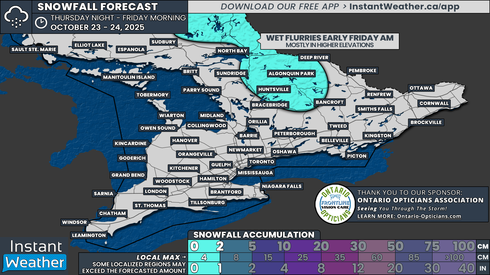
However, not everyone will escape a touch of wintry weather this week. The latest model data suggests that temperatures could dip close to the freezing mark across parts of Central Ontario late Thursday night into early Friday morning. With some lingering showers still moving through the region, a few areas could see those showers briefly mix with wet flurries before sunrise on Friday.
The best chance to spot the first flakes of the season will be across Northern Muskoka (including Huntsville and Sundridge), Algonquin Park, Bancroft and North Bay. That said, precipitation will be very scattered, and not all of these locations will see snow. Even if flakes do fall, they won’t stick around for long as the ground remains too warm and temperatures will quickly climb above freezing later in the morning.
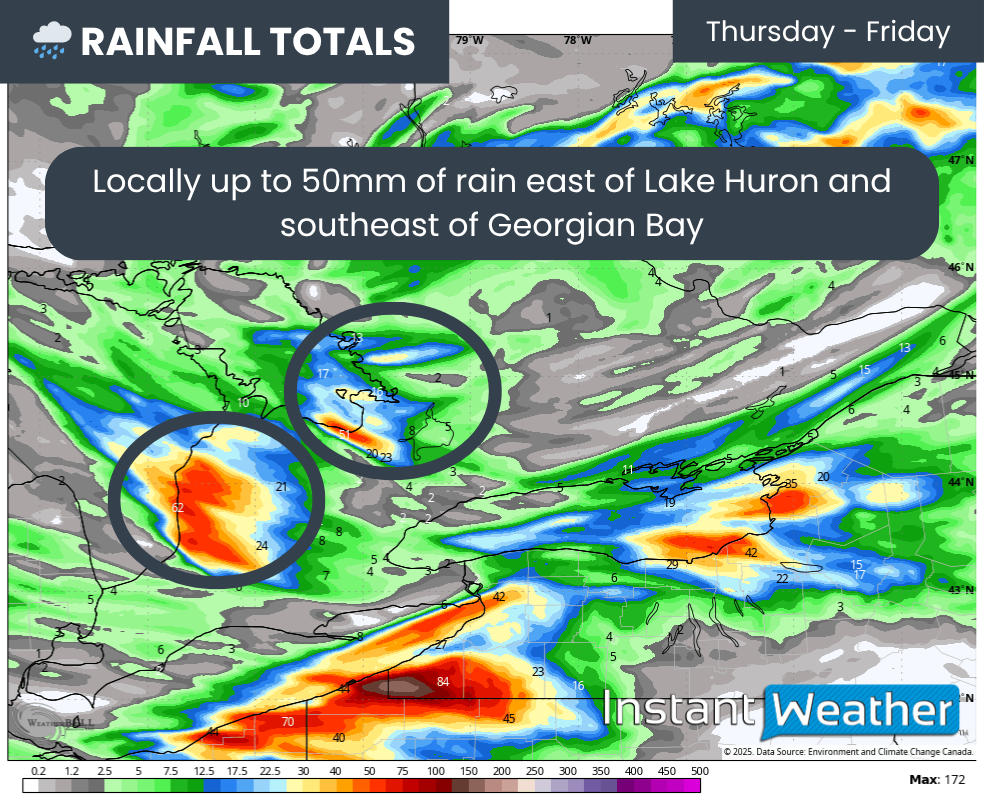
ESTIMATED TOTAL RAINFALL BY FRIDAY - MAP FROM WEATHERBELL
For those near Lake Huron and Georgian Bay, Thursday looks to be a wet one. Bands of lake-effect rain are expected to develop overnight Wednesday and linger through the day Thursday. As is typical with lake-effect events, rainfall totals will vary greatly over short distances depending on where the bands set up.
These bands are expected to wobble around through Thursday into Friday, spreading precipitation over a broader area rather than locking in on one spot. If one of the stronger bands does remain stationary for an extended time, localized flooding could occur, particularly near Kincardine and Goderich where some models show up to 50 mm of rainfall possible by Friday.
The lake-effect setup off Georgian Bay isn’t expected to be quite as strong, but parts of Simcoe County around Collingwood, Wasaga Beach and Barrie could still see locally up to 25 to 50 mm of rain. Again, the highest amounts will be very localized.
Elsewhere across Southern Ontario, expect occasional showers Thursday with generally less than 10 mm of rain as the heaviest precipitation remains confined to areas near the lakeshores.
By Friday morning, precipitation will gradually taper off as conditions become less favourable for lake-effect activity.
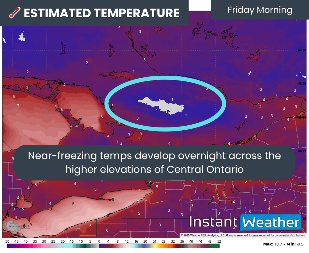
ESTIMATED AIR TEMPERATURE on friday morning - MAP FROM WEATHERBELL
Overnight Thursday into Friday, temperatures will drop into the low single digits across much of Southern Ontario, with some Central Ontario communities dipping to near or just below freezing.

PRECIP TYPE - MAP FROM WEATHERBELL
While it’s not the first time this fall that temperatures have touched the freezing mark, what’s different this time is that lingering precipitation from both the lake-effect activity and a system over Quebec could overlap with those cold temperatures.
If any precipitation develops overnight, it could easily fall as wet flurries given the near-freezing surface temperatures and even colder air aloft that would favour snow instead of rain.
NOTE: YOU CAN CLICK ON THE MAP TO OPEN A ZOOMABLE IMAGE

It’s worth noting that models disagree on how much precipitation will actually be present on Friday morning. Some may be underestimating light, scattered precipitation, which means there’s a chance flakes could be seen as far south as Huntsville and Bancroft. The most likely region for these flurries remains around North Bay and Algonquin Park, where multiple models consistently show light snow.
Unless you’re up early Friday morning, you’ll likely miss the brief appearance of the season’s first flakes. Any snow that does fall will melt quickly once temperatures climb above freezing, and no travel impacts are expected.


