‘Snow Day’ Forecast: Monday’s Blizzard Risk Expected to Result in Widespread School Bus Cancellations in Southern Ontario
/For an updated list of school bus cancellations & school closures, please visit our live article: https://instantweatherinc.com/article/2026/1/19/bus-cancellations
Intense snow squall activity, combined with bitterly cold wind chills and strong, gusty winds, is expected to create dangerous blizzard conditions across snowbelt regions near Lake Huron, Georgian Bay, Lake Ontario and Lake Erie on Monday.
Environment Canada has issued a range of winter weather alerts in response to this setup, including a strongly worded orange-level blizzard warning for areas east of Lake Huron as well as Prince Edward County. In these regions, wind gusts of 70 to 90 km/h combined with snowfall totals of 20 to 40 cm are expected to lead to near-zero visibility and extremely hazardous travel conditions.
With warnings of this severity in place, it is difficult to see how school buses could operate safely in the hardest hit areas. Blizzard conditions of this nature pose a significant safety risk for anyone on the roads, particularly during the afternoon hours when conditions are expected to be at their worst.
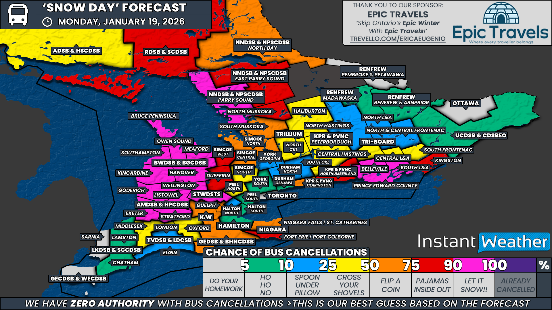
Because of this, we have near certainty of a snow day in several regions. A 90 percent chance of school bus cancellations has been assigned to all areas covered by the Bluewater District School Board and the Avon Maitland District School Board, along with Wellington County under the Upper Grand District School Board and Prince Edward County within Tri-Board Student Transportation Services. These regions sit directly within the blizzard warning area, where travel is expected to be extremely dangerous.
While not under the blizzard warning itself, we have also assigned a 90 percent chance to the Parry Sound region within the Near North District School Board, as well as Belleville and South Lennox and Addington under Tri-Board Student Transportation Services. These areas remain under snow squall warnings, which on their own are typically more than enough to prompt cancellations. Given the expected intensity and duration of the squalls, cancellations here appear highly likely.
A strong likelihood zone, with a 75 percent chance of a snow day, includes Kingston under Tri-Board, Northumberland County within the Kawartha Pine Ridge District School Board, the southern Niagara Region under the District School Board of Niagara, Dufferin County within the Upper Grand District School Board, the Simcoe West weather zone under the Simcoe County District School Board, North Muskoka under the Trillium Lakelands District School Board, East Parry Sound within the Near North District School Board, and all areas covered by the Rainbow District School Board. We are leaning toward cancellations in most of these regions, although some fall within boards that tend to be stricter with snow day decisions or sit just outside the most intense squall bands.
The probability drops off fairly quickly once you move outside the core snow squall risk zone, as lake effect impacts will be highly localized. In the toss-up category, where there is a 50 percent chance of a snow day, we have included the northern Niagara Region under the District School Board of Niagara, the Grand Erie District School Board, the Waterloo Region District School Board, Guelph within the Upper Grand District School Board, Clarington under the Kawartha Pine Ridge District School Board, the Simcoe Central and Simcoe North weather zones, South Muskoka under the Trillium Lakelands District School Board, and North Bay within the Near North District School Board.
A slight chance, around 25 percent, has been assigned to Middlesex and Oxford counties under the Thames Valley District School Board, northern Peel Region, the Simcoe South weather zone, Haliburton and North Kawartha Lakes within the Trillium Lakelands District School Board, Peterborough County under the Kawartha Pine Ridge District School Board, and Central Hastings, Central Lennox and Addington, and South Frontenac under Tri-Board Student Transportation Services. These regions are not currently under active warnings but remain close enough to the snow squall zones that a surprise cancellation cannot be ruled out if Environment Canada expands alert areas by Monday morning.
For the remainder of Southern Ontario, including Deep Southwestern Ontario, much of the Greater Toronto Area and the Ottawa Valley, the chance of a snow day remains low to very low. These regions are not expected to see significant impacts from lake effect snow, and travel conditions should remain manageable enough for school buses to operate as normal.
Disclaimer: Instant Weather has zero authority when it comes to bus and school closures.
It is completely up to the school boards, bus companies, local authorities, and parents to decide what is best for their children. This is our best guess based on our forecast.


