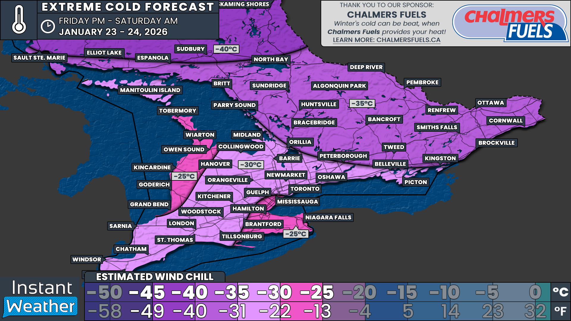
Potentially Coldest Night in Years Ahead for Southern Ontario as Arctic Air Sends Wind Chills Below -30°C
/
NOTE: YOU CAN CLICK ON THE MAP TO OPEN A ZOOMABLE IMAGE
An intense blast of Arctic air is set to surge across Ontario late Friday and into Saturday morning, bringing what could be the coldest conditions many areas have experienced in years. While snow squalls continue to dominate the forecast in parts of the province, the extreme cold arriving behind them will quickly become the more dangerous and widespread threat.
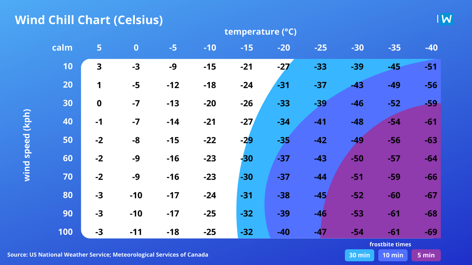
According to the latest data, wind chills will plunge sharply on Friday evening. Much of Southern Ontario will see overnight wind chills fall into the -30°C range, with several regions dropping into the -35°C to -40°C range by early Saturday morning. These values are cold enough to cause frostbite on exposed skin in as little as 10 minutes.
The coldest conditions are expected across Central and Northern Ontario, where the core of this Arctic air mass settles in. Wind chills near or below -40°C are likely across much of the north, including areas from Sudbury through North Bay. Some localized spots could briefly dip closer to -45°C.
Across cottage country and central sections of the province, including Muskoka, Parry Sound, Simcoe County, and Peterborough, wind chills between -35°C and -40°C look increasingly likely. This region has already been dealing with persistent snowfall, which will only add to the risk as stranded motorists or anyone caught outdoors for extended periods could be exposed to life-threatening cold very quickly.
The forecast shows much of the Greater Toronto Area, including Toronto, Mississauga, Brampton, and Vaughan, dropping into the -30°C to -35°C wind chill range by Saturday morning. This could mark the coldest morning Toronto has seen since 2016.
Across the western GTA, Hamilton, and Niagara, temperatures should hover in the low -20s, though wind chills will still make it feel close to -30˚C. A similar pattern is expected for parts of Bruce and Huron counties closer to Lake Huron, where slightly milder air off the lake may keep temperatures a few degrees warmer.
Saturday daytime temperatures will remain very cold, though not as brutally cold as seen in the morning. Expect temperatures in the teens with the wind chill making it feel below -20°C in many areas. Overnight Saturday, wind chills may return back to near -30°C into Sunday morning.
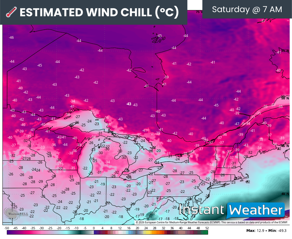
WIND CHILL - MAP FROM WEATHERBELL

Northern Ontario will bear the brunt of this event. Air temperatures are expected to drop toward -35°C, with wind chills approaching -45°C across a large portion of the region.
Some model guidance even suggests brief pockets of wind chills near -50°C, though confidence in those extreme values remains lower.
These conditions pose a serious risk to vulnerable individuals, particularly those who are unhoused or lack reliable access to warm shelter. Prolonged exposure to wind chills in the -30°C to -40°C range can become life threatening in a very short period of time. Even brief exposure during overnight hours can lead to frostbite or hypothermia, making this type of cold especially dangerous for people sleeping outdoors or in inadequately heated spaces.
The elderly are also at heightened risk during extreme cold events. Older adults may have reduced circulation, underlying health conditions, or difficulty sensing cold, all of which increase the risk of cold related illness. Those living alone or with limited mobility may struggle to maintain adequate indoor heating or may be unable to seek help quickly if something goes wrong.
Young children are another group that requires extra attention during this kind of cold. Their bodies lose heat more quickly, and they may not recognize early warning signs of frostbite or hypothermia. Even short trips outdoors without proper winter gear can become dangerous when wind chills drop this low.
Community members are encouraged to check in on neighbours, friends, and family, especially seniors or anyone known to be struggling with housing insecurity. Many municipalities and community organizations open warming centres during extreme cold events, and knowing where these resources are located can make a critical difference.
This kind of cold also places additional strain on infrastructure. Water mains are more vulnerable to freezing, older homes may struggle to retain heat, and power outages become more concerning when wind chills are this low. Anyone relying on supplemental heating should ensure proper ventilation, as carbon monoxide risk increases during prolonged cold spells.
Pet safety is another major concern during extreme cold events like this. Animals left outdoors for extended periods are at significant risk of frostbite and hypothermia, even if they are accustomed to winter conditions. Paw pads are especially vulnerable due to prolonged contact with snow and ice, and salt-treated surfaces can cause additional irritation.


