‘Snow Day’ Forecast: Many School Bus Cancellations & School Closures Likely on Monday as Southern Ontario Digs Out From Snowstorm
/
MAP UPDATED WITH ANNOUNCED CLOSURES AS OF 10:15 PM
For an updated list of school bus cancellations & school closures, please visit our live article: https://instantweatherinc.com/article/2026/1/26/bus-cancellations
Original Forecast:
A massive snowstorm is currently bearing down on Southern Ontario, with a particular focus on the Greater Toronto Area. Snowfall totals in some parts of the region are expected to approach or even exceed 50 cm by the time the storm winds down late Sunday.
While the heaviest snow is expected to taper off several hours before the Monday morning commute, cleanup efforts will only just be getting underway. With such an extreme amount of snow on the ground, school bus cancellations and even school closures are close to a certainty across large portions of the region.
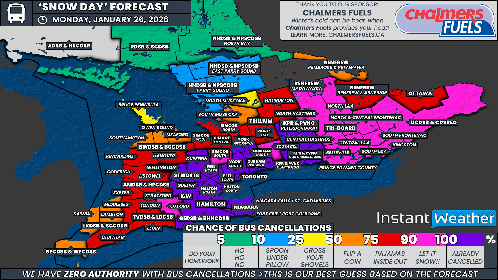
The greatest concern remains across the Golden Horseshoe, where strong lake enhancement is expected to significantly boost snowfall totals, as well as Eastern Ontario, where snow is forecast to linger into Monday morning.
In these regions, road conditions are expected to be extremely poor, with snow-covered and impassable routes likely during the morning hours. Because of this, we have assigned a 90 percent chance of a snow day on Monday.
This highest confidence zone includes the Hamilton-Wentworth District School Board, the Halton District School Board, the Peel District School Board, the Toronto District School Board, the southern portion of the Durham District School Board, Clarington and Northumberland counties under the Kawartha Pine Ridge District School Board, all areas covered by Tri-Board Student Transportation Services with the exception of North Hastings, and the Upper Canada District School Board.
Given the scale of this storm and the sheer volume of snow expected, it is difficult to see how buses could operate safely in these areas as crews work to dig out from the heaviest snowfall totals.
If there are any surprises within this highest confidence zone, they would most likely come from one or two of the more urban school boards within the Greater Toronto Area. In particular, parts of Durham Region or Hamilton could end up on the lower end of snowfall totals if lake enhancement underperforms locally. Even in that scenario, however, any decision to run buses would fall within the small remaining uncertainty already accounted for.
In the next tier, the probability of a snow day remains high, but confidence is slightly lower as outcomes will depend more heavily on how much snow falls outside of the core lake-enhanced zones. We have assigned a 75 percent chance to the Niagara District School Board, the Grand Erie District School Board, Oxford County under the Thames Valley District School Board, the Waterloo Region District School Board, the Upper Grand District School Board, the Simcoe South weather zone under the Simcoe County District School Board, South Kawartha Lakes under the Trillium Lakelands District School Board, Peterborough County under the Kawartha Pine Ridge District School Board, North Hastings under Tri-Board Student Transportation Services, the Madawaska region and Renfrew County under the Renfrew County District School Board, and the Ottawa region.
Ottawa in particular is expected to see significant snowfall, but given the urban nature of the school board and its typically higher threshold for cancellations, there remains a small chance buses could still run if conditions improve faster than expected.
In the toss-up category, where outcomes could genuinely go either way, we have assigned a 50 percent chance to the Greater Essex County District School Board, Chatham-Kent and Lambton County under the Lambton Kent District School Board, Middlesex and Elgin counties along with the City of London under the Thames Valley District School Board, the Avon Maitland District School Board, and the southern portions of Grey and Bruce counties under the Bluewater District School Board. In these areas, snowfall is expected to taper off earlier in the evening, giving road crews more time to clear routes before Monday morning. Whether that cleanup can keep pace with the snowfall will be the deciding factor.
East of Lake Huron, overall snowfall totals are expected to be lower. However, given the amount of snow that has already fallen in recent days, it would not take much additional accumulation to push parts of Huron, Perth and Grey-Bruce into another snow day scenario.
Farther north into Central Ontario, we have also assigned a 50 percent chance to the Simcoe Central and Simcoe West weather zones under the Simcoe County District School Board, North Kawartha Lakes and Haliburton within the Trillium Lakelands District School Board, and Pembroke under the Renfrew County District School Board. Snowfall totals here are expected to be lower overall, but the snow may not fully wrap up until overnight, leaving limited time for cleanup before the morning decision is made.
A slight chance, around 25 percent, has been assigned to Sarnia under the Lambton Kent District School Board, northern Grey and Bruce counties within the Bluewater District School Board, the Simcoe North weather zone, and Muskoka under the Trillium Lakelands District School Board. These regions are expected to see more modest impacts, generally in the range of 5 to 10 cm of additional snowfall. That amount alone would not normally reach cancellation thresholds, but given the broader regional impacts of this storm, a few surprise decisions cannot be completely ruled out.
Disclaimer: Instant Weather has zero authority when it comes to bus and school closures.
It is completely up to the school boards, bus companies, local authorities, and parents to decide what is best for their children. This is our best guess based on our forecast.


