Winter Returns to Ontario as End of Week Clipper Brings Widespread 10-20cm of Snow for the Start of March
/
NOTE: YOU CAN CLICK ON THE MAP TO OPEN A ZOOMABLE IMAGE
The first half of February has been nothing short of active across Ontario, with what felt like an endless stream of snowstorms dumping significant amounts of snow across many areas.
Fortunately, the latter half of the month provided a much-needed break from the active weather pattern. Milder temperatures pushed daytime highs above the freezing mark, leading to a steady melt of the extensive snowpack that had built up over previous weeks.
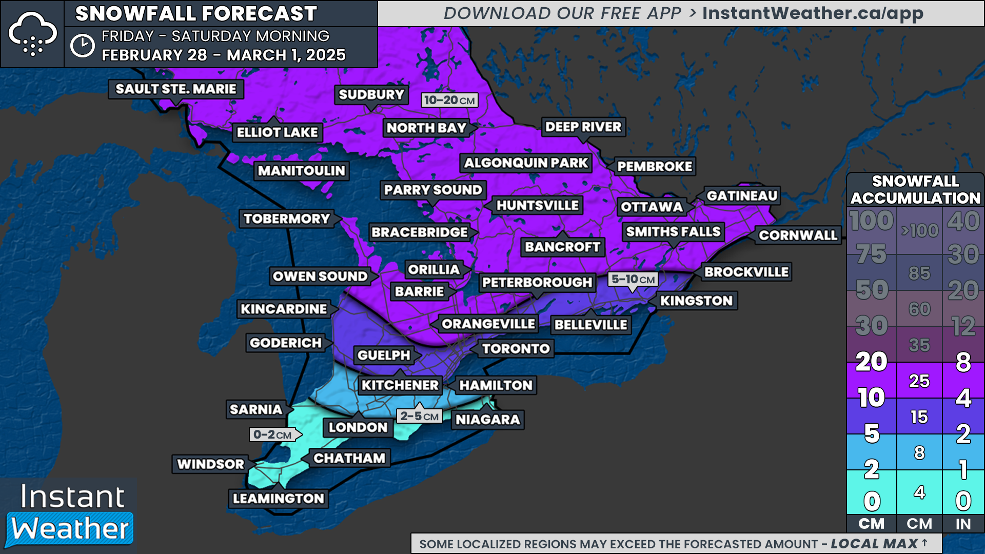
However, as the saying goes, all good things must come to an end. As we flip the calendar to March, active weather is set to make a comeback. A strong Alberta Clipper is on track to sweep across Northern and Southern Ontario on Friday, bringing widespread snowfall totals of 10 to 20 cm by Saturday.
In addition to the snow, this system will usher in much colder temperatures for the weekend. Wind chills are expected to drop into the -20s across Southern Ontario, while Northern Ontario will see even more bitter conditions, with wind chills dipping into the -30s. This will feel like a drastic change compared to the mild temperatures earlier this week, when parts of Southern Ontario saw highs in the mid to upper single digits.
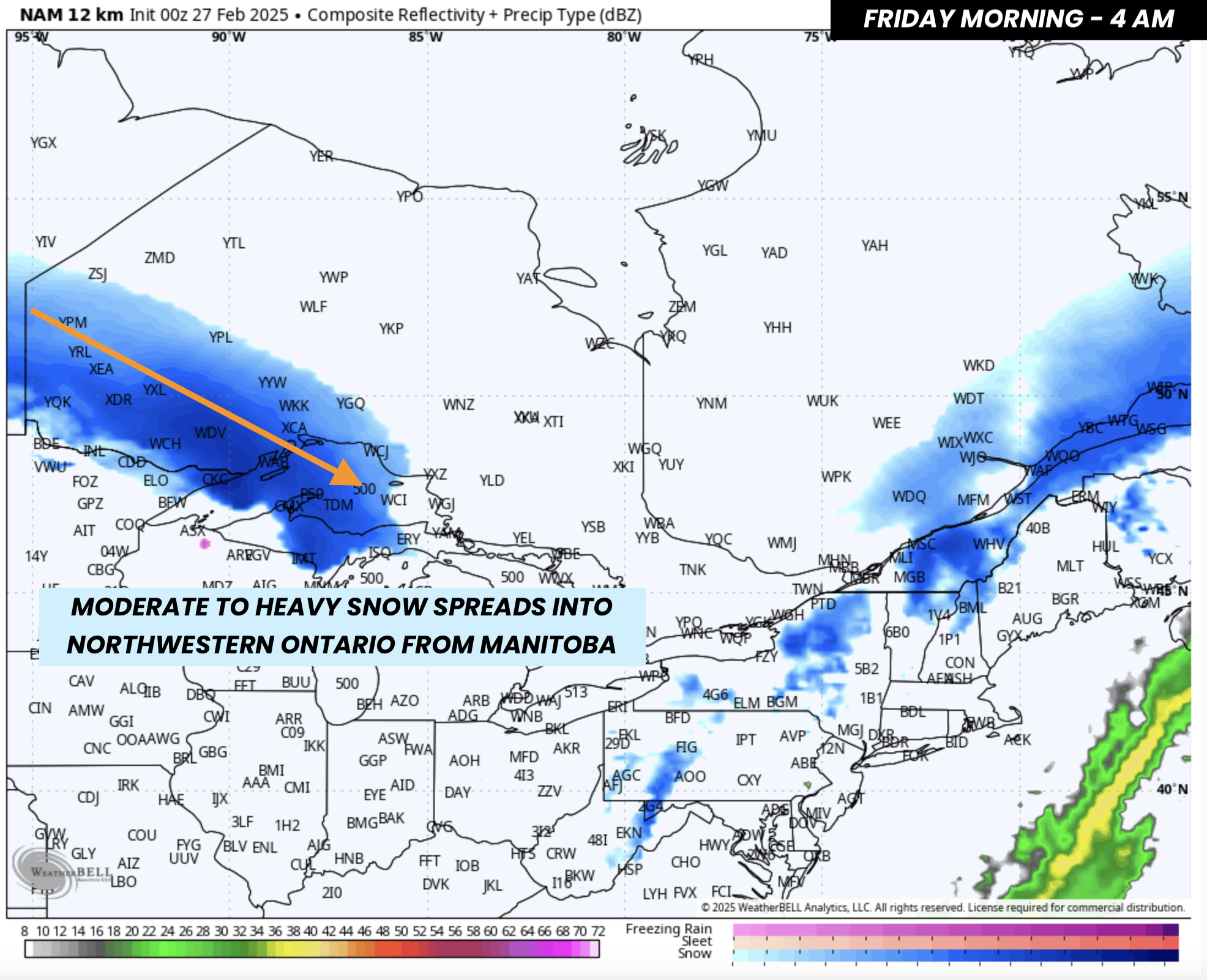
PRECIPITATION TYPE - MAP FROM WEATHERBELL
The first signs of the approaching clipper will be felt in Northwestern Ontario late Thursday night into early Friday morning, as snow spreads in from Central Manitoba.
Locations like Kenora, Dryden, and Thunder Bay will be the first to see snowfall, beginning around midnight and continuing into the early morning hours.

PRECIPITATION TYPE - MAP FROM WEATHERBELL
As the system moves eastward, snow will taper off across Northwestern Ontario by late Friday morning, while the heaviest snowfall shifts to Northeastern Ontario, particularly around Lake Superior and Georgian Bay.
By this time, we’ll also begin to see light snow entering Southwestern Ontario, particularly around Lake Huron, which will become more widespread as the day progresses.

HOURLY SNOWFALL RATE/intensity - MAP FROM WEATHERBELL
By Friday afternoon, snow will spread into Southern Ontario, becoming more steady across the Greater Toronto Area (GTA).
The heaviest accumulations will likely be concentrated along the Lake Huron and Georgian Bay shorelines, particularly in Grey-Bruce, Muskoka, and Parry Sound. Lake enhancement in these areas could provide an extra boost to snowfall totals.

HOURLY SNOWFALL RATE/intensity - MAP FROM WEATHERBELL
The worst conditions for Southern Ontario will occur Friday evening, when snowfall rates could reach 2 to 4 cm per hour in the most intense bands. The snow will be widespread, impacting Central and Eastern Ontario, the GTA, and Grey-Bruce.
Additionally, blowing snow may become a significant issue, as wind gusts of 40 to 70 km/h could reduce visibility on the roads.

HOURLY SNOWFALL RATE/intensity - MAP FROM WEATHERBELL
By midnight, snowfall intensity will begin to gradually diminish, and most areas southwest of Lake Simcoe—including the GTA—should see snow tapering off. However, lake-effect snow east of Lake Huron may continue into the overnight hours.
Meanwhile, light snow will persist overnight across Central and Eastern Ontario, but it is expected to slowly taper off by Saturday morning.

NOTE: YOU CAN CLICK ON THE MAP TO OPEN A ZOOMABLE IMAGE
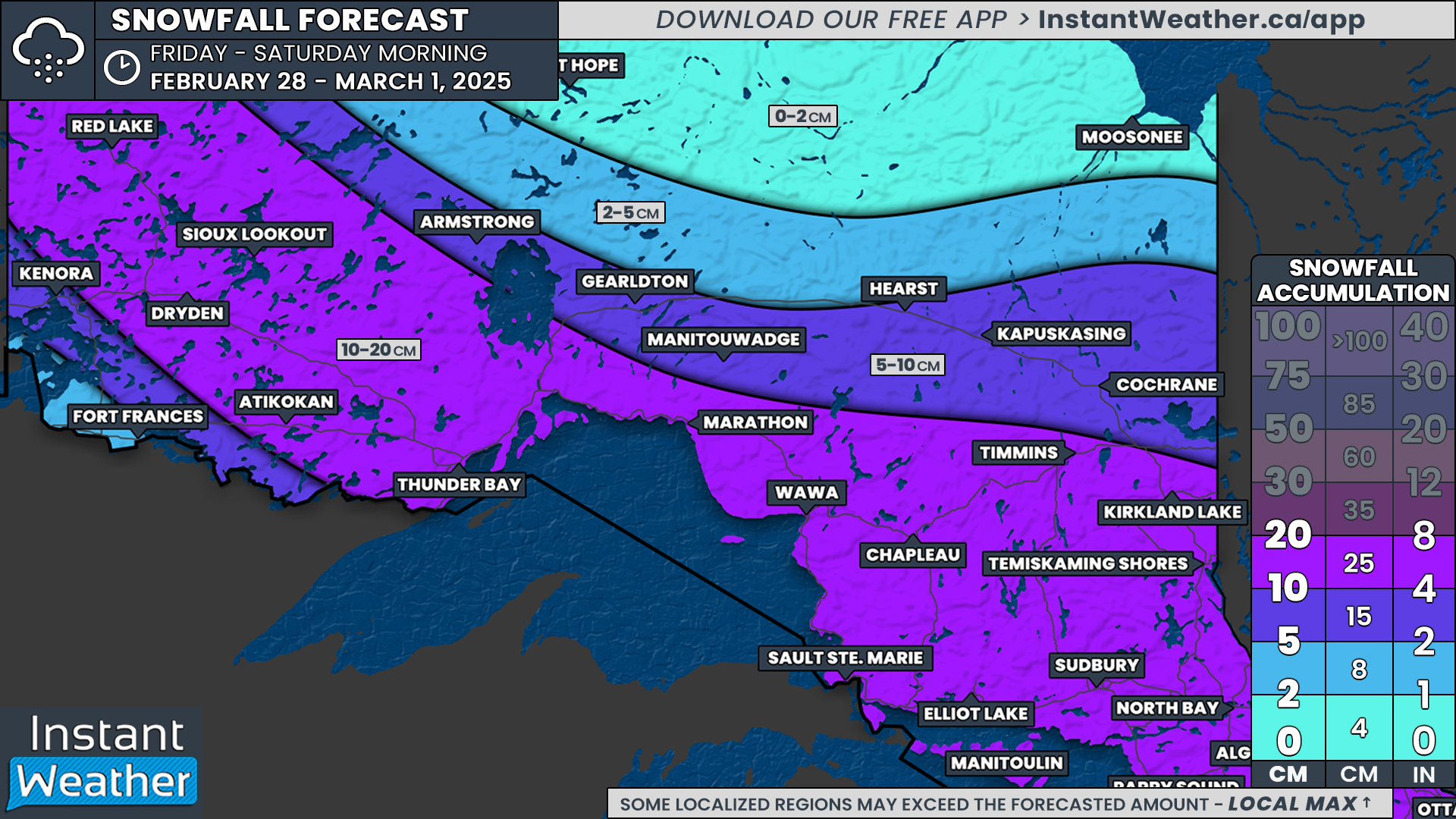
In terms of Alberta Clippers, this one appears to be on the stronger side, with a fair amount of moisture to work with. While it will be fast-moving, we are still expecting widespread snowfall totals between 10 to 20 cm across much of Central and Eastern Ontario by Saturday morning.
Some areas could overachieve, with up to 25 cm possible, especially in regions east of Georgian Bay, where lake enhancement could further boost totals.
Further south, including areas like Goderich, Kitchener, Toronto, Peterborough, and Kingston, lower snowfall amounts are expected. While these regions will still see fresh snow, totals will likely range between 5 to 10 cm due to lower snowfall rates compared to areas further north.
For Deep Southwestern Ontario, including London and the Niagara region, snowfall will be minimal, with less than 5 cm expected.
NOTE: YOU CAN CLICK ON THE MAP TO OPEN A ZOOMABLE IMAGE
Across Northern Ontario, a wide swath of the region is on track to receive 10 to 20 cm from this system, including Dryden, Thunder Bay, Sault Ste. Marie, Timmins, Sudbury, and North Bay.
As with the south, there is potential for some areas to overperform, particularly east of Lake Superior, where localized totals of up to 25 cm are possible.
With accumulating snow, strong winds, and plummeting temperatures, this clipper will bring notable impacts heading into the weekend. Stay tuned for further updates as the system approaches!