Southern Ontario Faces Ice Threat Then Snow as Fast Moving Winter System Disrupts Tuesday Travel
/
NOTE: YOU CAN CLICK ON THE MAP TO OPEN A ZOOMABLE IMAGE
A fast changing winter system is expected to sweep through much of Southern Ontario during the day on Tuesday, bringing a messy mix of precipitation types and rapidly changing conditions. While this is not expected to be a blockbuster storm on its own, the combination of freezing rain followed by snow could still create localized impacts, especially during the afternoon and evening hours.
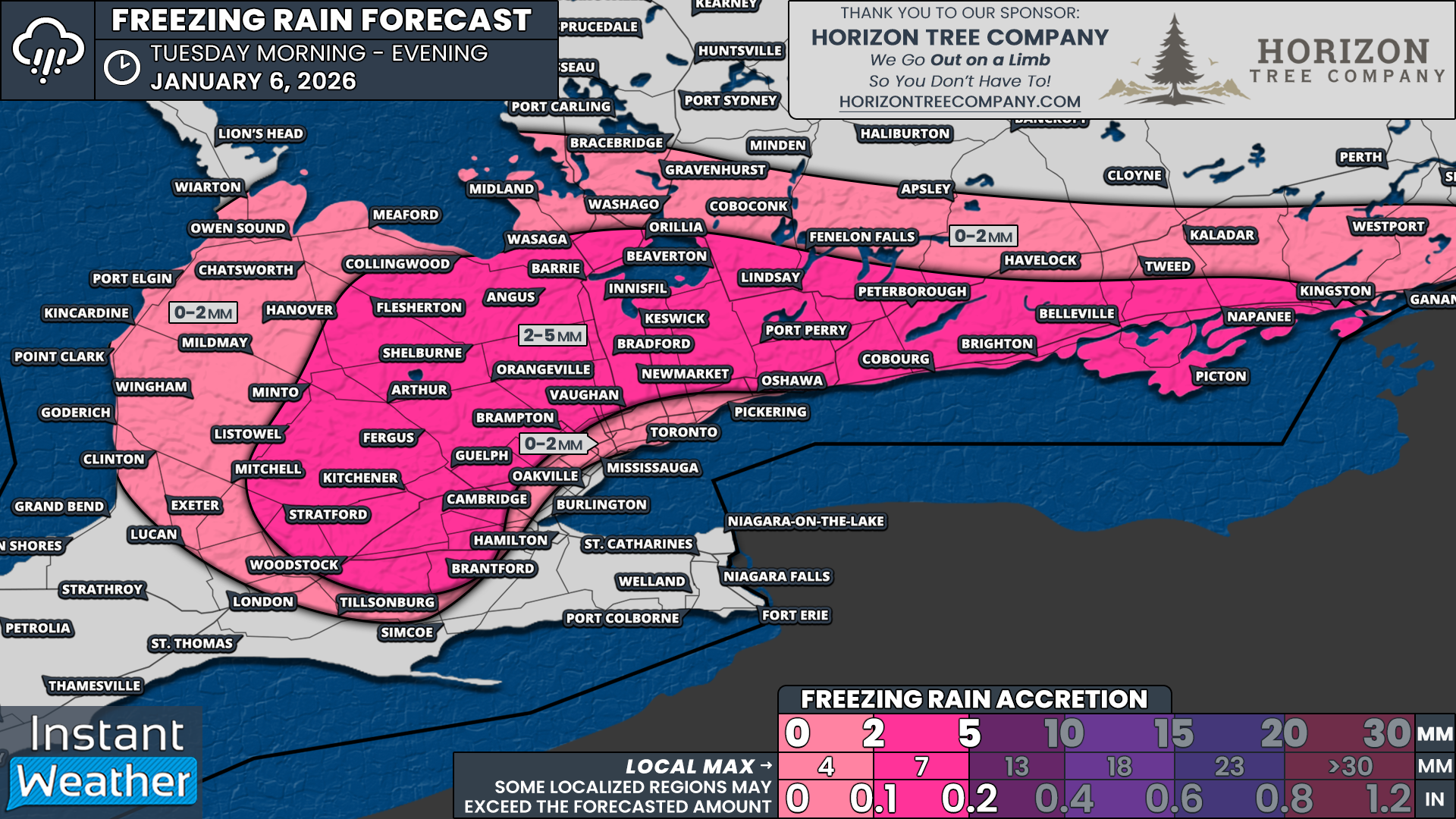
The first part of this system will arrive Tuesday morning and early afternoon, with freezing rain becoming the dominant concern for several regions. Widespread freezing rain is expected to develop across the higher elevations northwest of the GTA, extending into areas north of Lake Simcoe and along the Lake Ontario shoreline from Peterborough eastward toward Kingston. These elevated regions tend to hang onto colder air longer, making them more vulnerable to icing during marginal setups like this one.
Freezing rain is expected to begin developing across parts of Southwestern Ontario east of Lake Huron, including the Kitchener area and the Dundalk Highlands, by the late morning hours on Tuesday. From there, the freezing rain shield is forecast to spread north and eastward through the afternoon, reaching areas around Lake Simcoe such as Barrie, along with York Region, Durham Region, Kawartha Lakes, Peterborough and eventually Kingston.
In some locations, the precipitation may initially fall as ice pellets during the early afternoon before transitioning over to freezing rain for a few hours. This could help slightly limit ice accretion at first, but any freezing rain will still make untreated roads, sidewalks and elevated surfaces quite slick as temperatures remain near or below freezing.
For the GTA, the freezing rain threat looks more limited, but it cannot be ruled out entirely. There could be an hour or two of freezing rain during the afternoon, especially in the northern parts of the region, before precipitation transitions over to light snow by the evening. Meanwhile, areas in Deep Southwestern Ontario and the Niagara region are expected to remain mostly on the rain side of this system, with temperatures hovering in the low single digits above freezing for much of the event.
One of the more unusual aspects of this system is what happens after the freezing rain ends. While ice accretion amounts are expected to generally remain manageable, in the range of 2 to 5 millimetres for areas northwest of the GTA into Simcoe County and eastward through Peterborough and Kingston, there will not be a quick or clean warm-up. Instead, colder air is expected to surge back in, overpowering the warm layer aloft.
NOTE: YOU CAN CLICK ON THE MAP TO OPEN A ZOOMABLE IMAGE

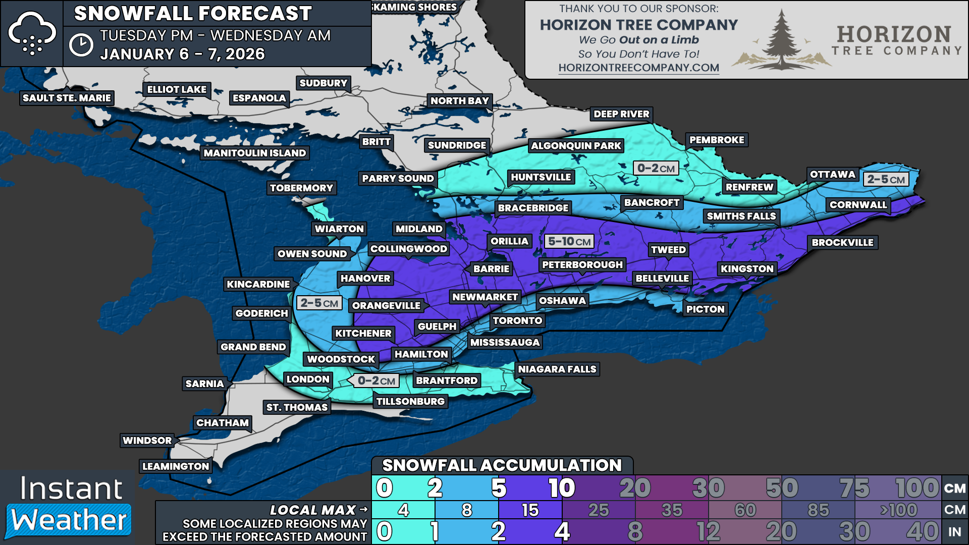
As this colder air deepens, precipitation is forecast to transition back to snow by the early evening and continue into the overnight hours across Central and Eastern Ontario, as well as the higher elevations northwest of the GTA. This changeover could happen fairly quickly once it begins, leading to periods of steady snowfall through Tuesday night.
Snowfall totals from this second phase of the system are expected to range from 5 to 10 centimetres across many of the same areas that experienced freezing rain earlier in the day. This includes parts of Simcoe County, Kawartha Lakes, Peterborough and areas toward Kingston, as well as elevated terrain northwest of the GTA.
While neither the ice accretion nor the snowfall amounts are particularly extreme on their own, the combined impact could be more significant. Even light ice accretion can weaken tree branches and add extra weight to power lines, and when followed by several centimetres of heavy, wet snow, the risk of isolated power outages and downed branches increases.
Elsewhere, including the GTA, regions east of Lake Huron and parts of northern Central and Eastern Ontario, snowfall totals are expected to be lighter, generally in the 2 to 5 centimetre range. This should still be enough to create slick travel conditions Tuesday evening and overnight, especially as temperatures drop back below freezing.
For the Ottawa region, this system looks less impressive overall. Precipitation amounts appear limited, and snowfall totals may struggle to reach the 2 centimetre mark by the time everything wraps up.
As always with systems like this, small changes in temperature can make a big difference in precipitation type and impacts. Drivers should be prepared for rapidly changing road conditions throughout the day on Tuesday, especially in areas that see freezing rain followed by accumulating snow.


