Up to 20cm of Heavy Snow to Slam Ottawa, Central and Eastern Ontario Friday as Evening Commute Faces Travel Headaches
/
NOTE: YOU CAN CLICK ON THE MAP TO OPEN A ZOOMABLE IMAGE

Get 20% off on stays until April when you book online with code: 20years
Our second messy winter storm of the week is lining up for parts of Southern Ontario, and this one looks timed almost perfectly to cause headaches for the Friday evening commute with a burst of heavy snow in some areas and a messy mix in others.
After many communities dealt with significant impacts earlier in the week, there is very little breathing room before this next system arrives. While Wednesday’s storm largely spared much of Central and Eastern Ontario from the worst of it, this next round is expected to target many of those same regions that missed out last time, shifting the focus farther north and east.
This system comes with its own set of challenges. Temperatures will be hovering very close to the freezing mark for a large portion of the day on Friday, and that makes the forecast particularly sensitive. A difference of just a degree or two will determine whether you see cold rain, freezing rain, ice pellets, or heavy wet snow. That small shift in temperature could dramatically change road conditions and overall impacts in a short amount of time.
Some forecast models continue to show a slightly colder solution, which would support more mixing through the late morning and early afternoon hours. That includes a risk of freezing rain and ice pellets, especially across the higher elevations northwest of the Greater Toronto Area and east of Lake Simcoe.
Other models are holding onto slightly warmer air at the surface, which would keep precipitation mainly as rain through that same window and significantly limit any icing threat. This is the fine line we are watching very closely.
What does appear more certain is that colder air will remain firmly in place across northern sections of Central and Eastern Ontario throughout the day. That means once precipitation begins early Friday afternoon in those areas, it should fall predominantly as snow.
With colder air already established, there will be fewer questions about precipitation type and more focus on how heavy the snow becomes and how quickly it accumulates.
Although this storm is not expected to be a long-duration event, its short and intense nature may actually increase the impact. Several hours of heavy snowfall are likely through the late afternoon and evening, particularly across Eastern Ontario.
Snowfall rates could approach 5 cm per hour in the most intense bands, especially around the Ottawa Valley. When snow falls that hard, accumulation can happen rapidly, and visibility can drop off very quickly, creating hazardous travel conditions in a matter of minutes.
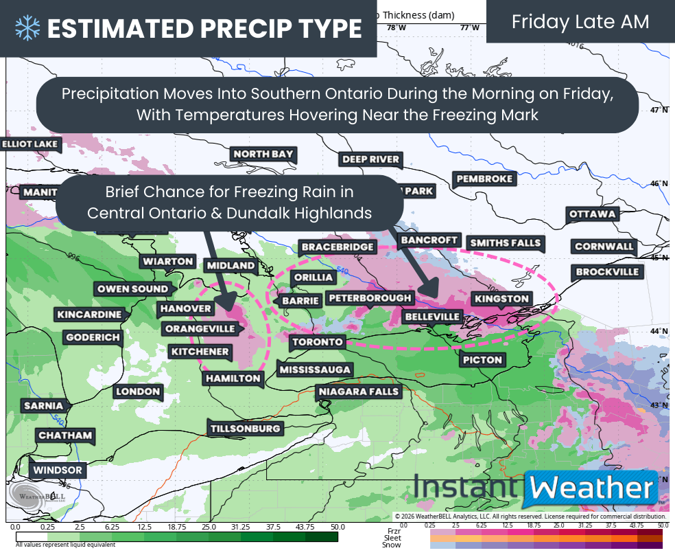
PRECIP TYPE - MAP FROM WEATHERBELL
Across Southwestern Ontario and into the Golden Horseshoe, the story will look a little different. Precipitation is expected to arrive overnight in the southwest first, spreading northeast through the morning hours.
With temperatures rising slightly overnight and into the morning, much of the area southeast of Lake Simcoe should see mainly rain through the early to mid-morning hours. For many, the first half of Friday may feel more like a cold and damp day rather than a winter storm.
The tricky zone will set up somewhere across southern Central and Eastern Ontario, where that milder air meets the colder air to the north. In this transition zone, we could see a brief period of freezing rain, changing to ice pellets, and then eventually to snow as colder air deepens. That could allow for some localized icing through parts of Simcoe County, Kawartha Lakes, Peterborough and Kingston during the late morning hours, roughly between 9 and 11 AM.
A pocket of near or slightly below freezing temperatures may also develop along the higher elevations of the Dundalk Highlands around Orangeville.
Not all guidance supports this icing scenario. Some models keep temperatures just above freezing long enough to prevent freezing rain from developing, limiting the risk to plain rain before a changeover to snow later in the day.
Others lean more toward an ice pellet mix rather than significant freezing rain, as colder air aloft begins to erode the warm layer needed to sustain icing. This is where small temperature differences will make a big impact on the ground.
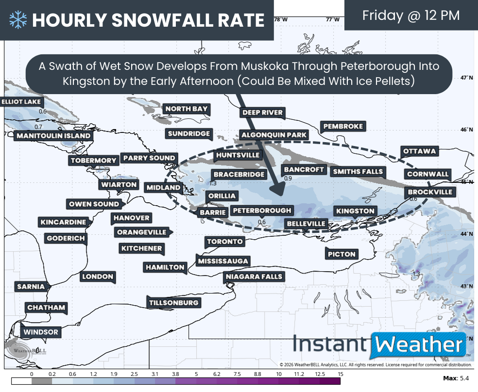
Hourly snowfall rates (cm) - MAP FROM WEATHERBELL
By around midday, the leading edge of steadier precipitation should be pushing deeper into Central and Eastern Ontario. As it runs into that stubborn pocket of cold air across northern sections and into the Ottawa Valley, a swath of heavy wet snow is expected to develop. This band is likely to stretch from Muskoka through Peterborough and into Kingston, gradually intensifying through the afternoon.
There may be some initial mixing with ice pellets that limits accumulation during the first couple of hours, but as colder air continues to settle in, snowfall rates are expected to increase.
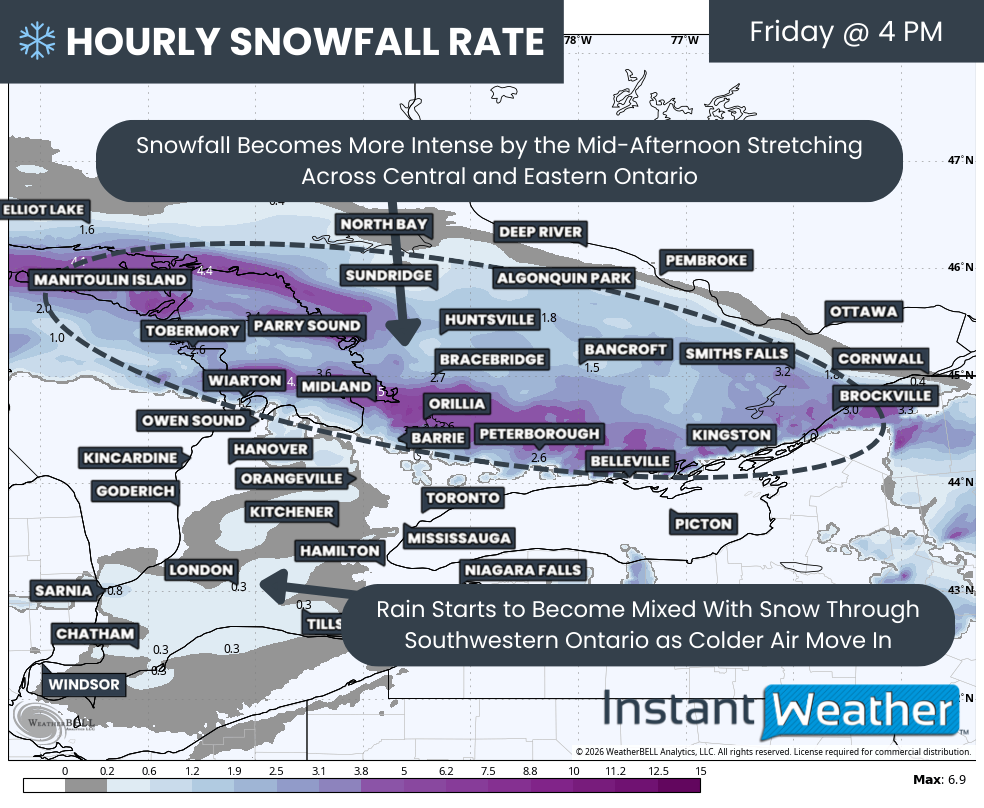
Hourly snowfall rates (cm) - MAP FROM WEATHERBELL
Conditions will begin to deteriorate more rapidly later in the afternoon as heavier bands organize. Snowfall rates of 2 to 4 cm per hour appear likely through much of Central and Eastern Ontario, with the heaviest corridor from Lake Simcoe through Peterborough and into Kingston. Snow will also expand into the Ottawa Valley, starting lighter at first before ramping up closer to the dinner hour.
The mixing line is forecast to gradually sink south and east through the afternoon, allowing areas such as Barrie, Grey Bruce and Belleville to transition over to heavier snow as well.
Meanwhile, across Southwestern Ontario and the Golden Horseshoe, colder air will begin to undercut the departing rain. While much of the steadier precipitation may fall as rain before temperatures drop, any lingering precipitation is expected to change over to wet snow late in the afternoon and early evening.
That changeover timing is not ideal. Even a few hours of steady wet snow during the evening commute can create slick roads, especially as temperatures dip below freezing. Gusty winds approaching 50 to 60 km per hour in some areas may also lead to areas of blowing snow where accumulation occurs, reducing visibility and adding to the travel challenges.
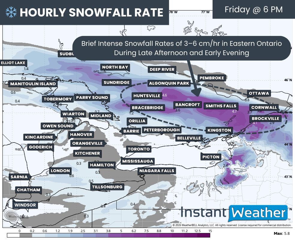
Hourly snowfall rates (cm) - MAP FROM WEATHERBELL
Because this system is moving fairly quickly, the window for the worst conditions will likely be concentrated into just a few hours during the late afternoon and early evening. That is when snowfall rates will be at their peak and when road crews will have the hardest time keeping up. Sudden bursts of heavy snow could overwhelm plows and lead to rapidly deteriorating conditions.
The most intense band is expected to sweep through Eastern Ontario during the late afternoon and early evening, likely reaching the Ottawa Valley between roughly 6 and 8 PM. Snowfall rates approaching or even exceeding 5 cm per hour are possible within this band. Commuters should be prepared for sudden drops in visibility and rapidly accumulating snow on untreated surfaces.
Across Southwestern Ontario and the Greater Toronto Area, snowfall amounts are expected to be much lighter. Most locations in these areas will see rain primarily, followed by a brief period of snow late in the day. While totals are expected to remain under 2 cm in many spots, that small amount combined with falling temperatures could still lead to icy patches Friday evening.
Snow is expected to taper off from west to east through the late evening hours, with most areas seeing precipitation end by around midnight. Some scattered flurries may linger into the overnight hours and into early Saturday morning, but the main storm impacts should be over by then.
NOTE: YOU CAN CLICK ON THE MAP TO OPEN A ZOOMABLE IMAGE

Get 20% off on stays until April when you book online with code: 20years
In terms of snowfall totals, Eastern Ontario is expected to see the highest amounts. We are forecasting 10 to 20 cm for communities including Ottawa, Cornwall, Brockville, Smiths Falls, Renfrew, Bancroft, Tweed and Huntsville. Locally higher totals up to 25 cm are possible where the most intense snow bands set up for a few hours.
Amounts are expected to taper off to the south and east, where mixing plays a larger role, and overall precipitation amounts are slightly lower. Locations such as Kingston, Belleville, Peterborough, Orillia, Midland, Tobermory, Bracebridge, Parry Sound, Sundridge, North Bay and Sudbury can generally expect 5 to 10 cm. However, with temperatures hovering near freezing at times, there is a chance some of that snow may partially melt or compact, which could reduce final totals.
Owen Sound, Collingwood and Barrie are forecast to see around 2 to 5 cm. These communities sit very close to the mixing line, so a small shift colder could allow them to overperform and reach closer to 5 to 10 cm in localized areas.
Less than 2 cm is expected across much of Southwestern Ontario and the Greater Toronto Area, with most of that falling after the rain transitions to snow late in the day.


