‘Snow Day’ Forecast: Up to 10-20cm of Snow on Tuesday Could Bring Widespread Bus Cancellations to Parts of Southern Ontario
/
For an updated list of school bus cancellations & school closures, please visit our live article: https://instantweatherinc.com/article/2026/2/10/bus-cancellations
NOTE: YOU CAN CLICK ON THE MAP TO OPEN A ZOOMABLE IMAGE
Widespread snow is expected to spread across much of Central and Eastern Ontario overnight and continue into Tuesday morning. This system will bring a steady period of snowfall that is likely to create hazardous travel conditions through the morning and into the early afternoon, with reduced visibility and snow-covered roads becoming an issue during the busiest travel periods of the day.
While snowfall totals are not expected to be extreme, most areas will see general accumulations in the 10 to 15 cm range, with localized totals approaching 20 cm where snowfall rates remain steadier. The bigger concern with this event is not the total amount of snow, but rather the timing, as the worst conditions are expected to coincide with the morning commute and linger well into the afternoon.
Because of this, there is a meaningful chance that some school boards will opt to cancel buses on Tuesday, particularly in regions where snow is actively falling at the time decisions are made early in the morning.
At this time, Environment Canada has opted to issue a special weather statement rather than a snowfall warning, citing slightly lower totals than what some models are suggesting. This adds an extra layer of uncertainty, as many school boards are less likely to act proactively without a formal warning in place. Should this be upgraded to a snowfall warning by Tuesday morning, confidence in bus cancellations would increase quickly.
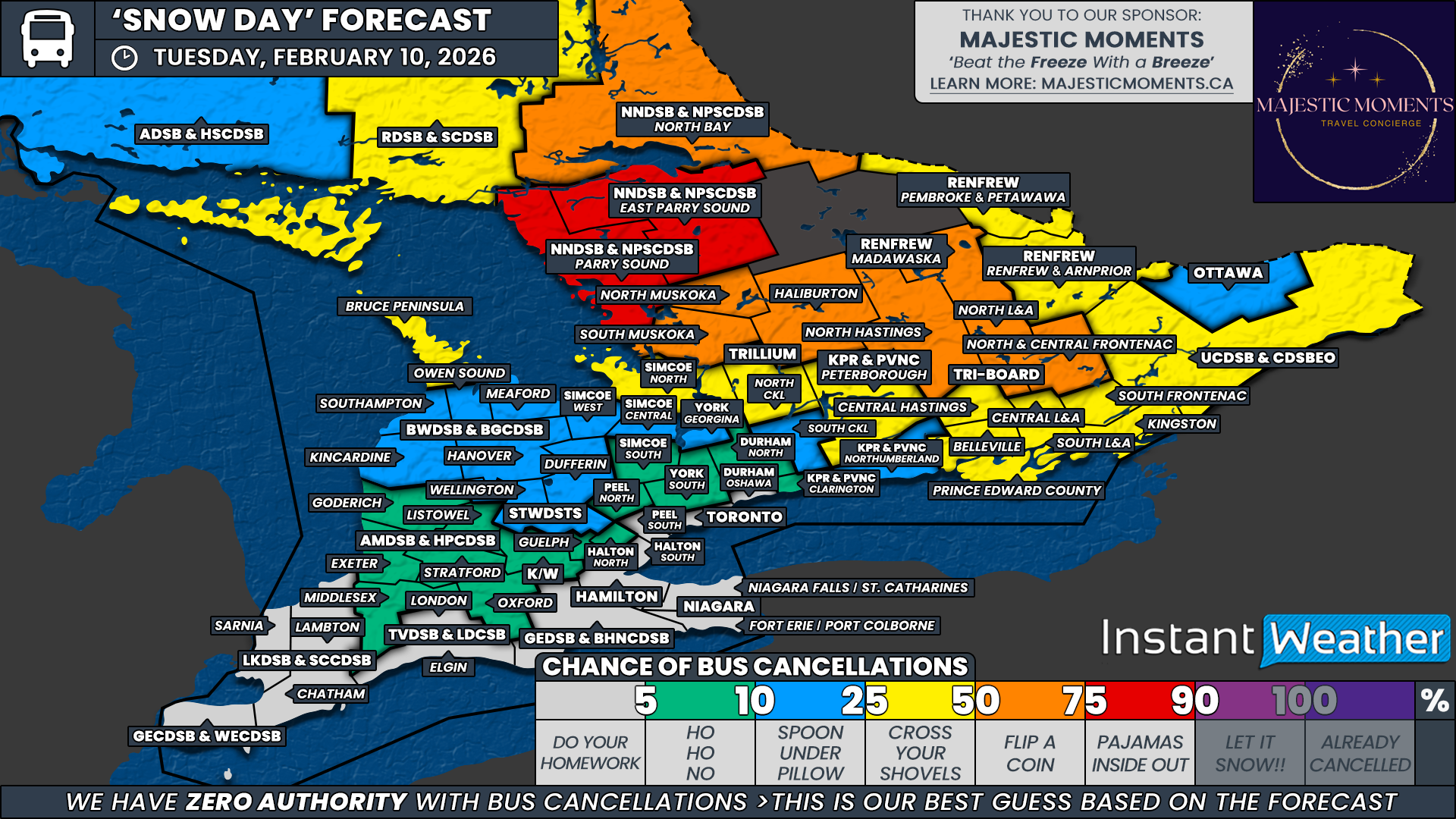
Our highest confidence for school bus cancellations is focused on areas where snow is expected to be ongoing during the decision window. This includes Parry Sound and East Parry Sound under the Near North District School Board. With steady snowfall expected through the early morning hours and limited time for cleanup, we have given these regions a 75% chance of bus cancellations on Tuesday.
In the next tier, we have a broad toss-up zone with a 50% chance, where outcomes could genuinely go either way. This includes Muskoka and Haliburton under the Trillium Lakelands District School Board, North Bay within the Near North District School Board, North Hastings, North Lennox and Addington, and North and Central Frontenac under Tri-Board Student Transportation Services, along with the Madawaska region under the Renfrew County District School Board.
Confidence is lower in these areas for a few reasons. In the case of TLDSB, this school board has been particularly strict with bus cancellations this season and may decide that this event does not meet their threshold without a snowfall warning. In Eastern Ontario, snowfall may not begin until later in the morning, meaning boards would need to be proactive based on forecast conditions rather than what is occurring at decision time. Regions that historically tend to act more cautiously have been placed into this 50% category.
A wider group of regions has been assigned a slight chance, around 25%. This includes the Bruce Peninsula under the Bluewater District School Board, the Simcoe North weather zone under the Simcoe County District School Board, North Kawartha Lakes under the Trillium Lakelands District School Board, Peterborough County under the Kawartha Pine Ridge District School Board, the remaining Tri-Board regions, the Upper Canada District School Board, and the remainder of the Renfrew County District School Board. These areas sit just outside the zone of heaviest snowfall during the school day, making it questionable whether conditions will deteriorate enough to prompt cancellations.
For Ottawa, we have gone with a 10 percent chance. While some snow is expected, this system is not currently forecast to be intense enough to meet the higher threshold typically required for cancellations in a large urban school board. We have also extended a very low to low chance into parts of the Golden Horseshoe, particularly rural sections that could see a brief risk of freezing rain during the afternoon. If Environment Canada issues an alert for freezing rain by Tuesday morning, probabilities would increase, but confidence is not high enough at this point to go beyond a low chance.
No school bus cancellations are expected across Deep Southwestern Ontario or the urban school boards of the Greater Toronto Area. Snowfall in these regions will be minimal, and some areas may even climb above the freezing mark during the day on Tuesday, further reducing the likelihood of travel disruptions.
Disclaimer: Instant Weather has zero authority when it comes to bus and school closures.
It is completely up to the school boards, bus companies, local authorities, and parents to decide what is best for their children. This is our best guess based on our forecast.


