Snowy Blast Could Bring 10-20cm of Fresh Snow to a Wide Swath of Southern Ontario on Tuesday
/
NOTE: YOU CAN CLICK ON THE MAP TO OPEN A ZOOMABLE IMAGE
The month of February has certainly been a lot quieter on the snow front across Southern Ontario compared to what many experienced during January. That stretch featured relentless lake effect squalls and several high-impact winter storms that seemed to roll through one after another. In contrast, February has so far offered more breaks between systems, even though we’ve still spent plenty of time locked in the deep freeze.
While temperatures have slipped well below seasonal levels again, the good news is that this cold snap is not expected to last. A gradual warming trend is forecast to take hold as we head into the middle of this week, with temperatures slowly climbing back toward seasonal norms as early as Tuesday.
However, that return to more seasonable temperatures comes with a trade-off. As we moderate, Southern Ontario will once again find itself squarely within the active storm track. And that pattern shift looks set to make itself known very quickly, as we continue to monitor a potentially widespread snow maker expected to impact the region on Tuesday.
A developing system is forecast to slide across Southern Ontario beginning overnight Monday and continuing through much of the day on Tuesday. Current guidance suggests this system has the potential to produce a broad swath of accumulating snow, particularly across Central and Eastern Ontario.
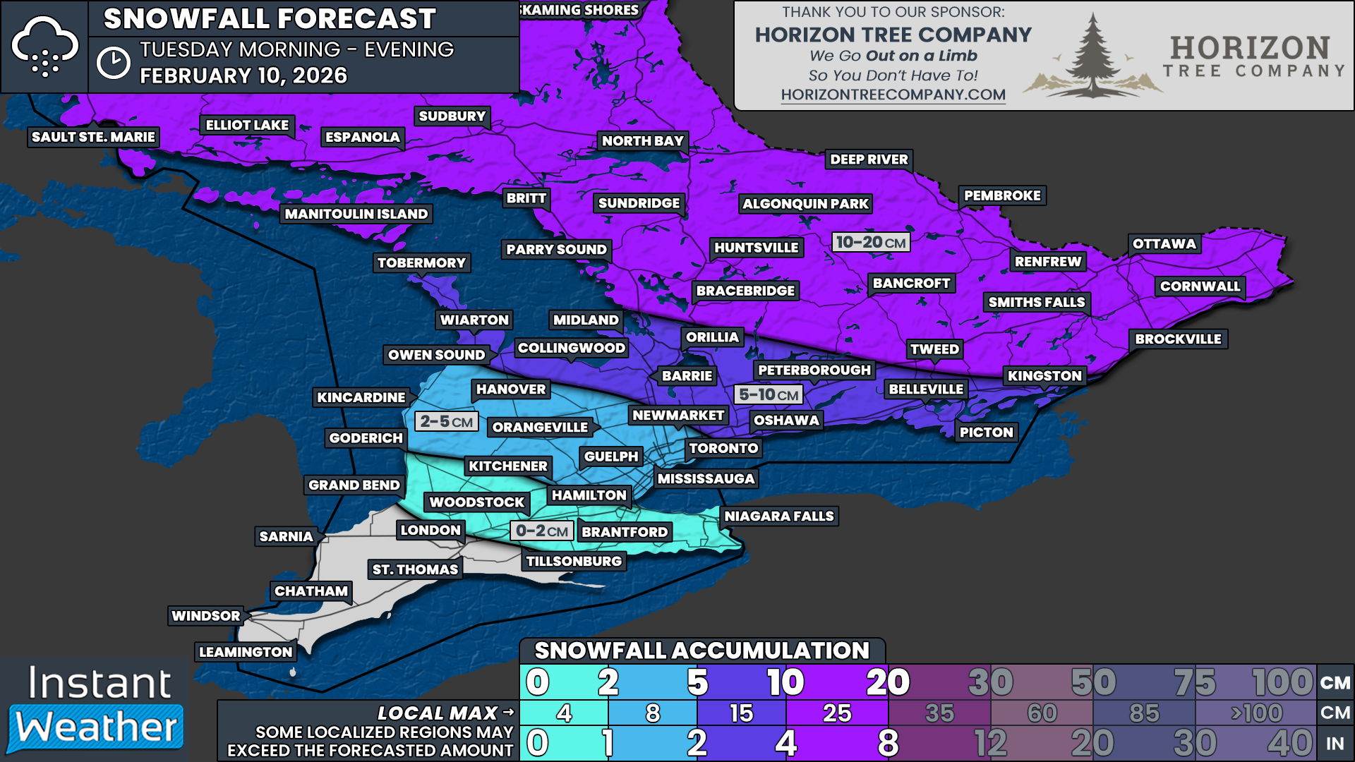
At this point, the highest confidence area for significant snowfall lies across Central and Eastern Ontario, where widespread accumulations of 10 to 20cm appear increasingly likely. While details are still being refined, confidence is growing that this will be a high-impact event for travel.
Given the timing, this system is expected to cause issues during both the Tuesday morning and evening commutes. Snow is likely to be ongoing during the morning rush, with roads becoming increasingly snow covered as the day progresses. Conditions may briefly improve in some western areas by late afternoon, but parts of Eastern Ontario could be dealing with their worst conditions right as the evening commute begins.
In addition to snow, there is also a concern for mixed precipitation in parts of Southwestern Ontario and the western GTA. Some guidance continues to show a risk for freezing drizzle or freezing rain developing late Tuesday morning into the early afternoon, particularly along the London, Kitchener, Guelph and Hamilton corridor.
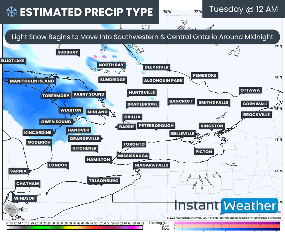
PRECIP TYPE - MAP FROM WEATHERBELL
The system itself is expected to begin spreading into Southern Ontario from the northwest shortly after midnight Monday night into early Tuesday morning. The first areas to see snow will likely be Grey Bruce, Parry Sound, Simcoe County and Muskoka, with coverage expanding steadily southeastward through the pre-dawn hours.
By early Tuesday morning, snow should be fairly widespread across Central Ontario, with conditions continuing to deteriorate as snowfall rates increase.
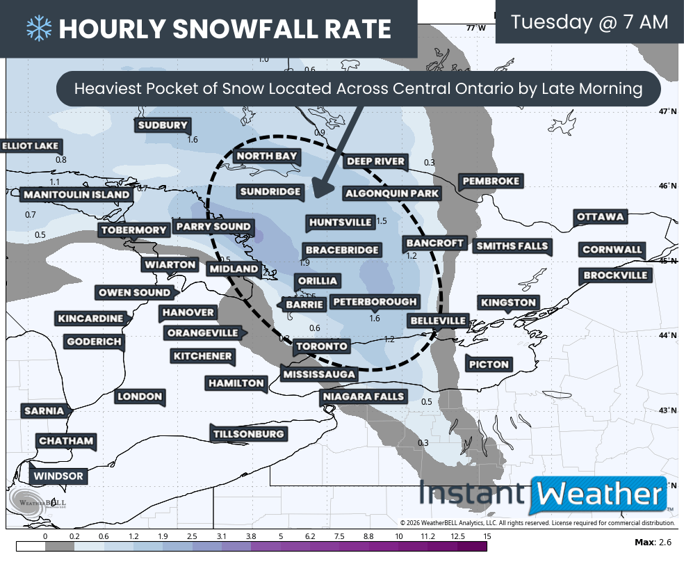
Hourly snowfall rates (cm) - MAP FROM WEATHERBELL
As we move into the mid-morning hours, snow is expected to expand into the Highway 401 corridor east of Toronto, stretching toward Belleville, Kingston and beyond.
The heaviest pocket of snow during the morning hours is expected across parts of Central Ontario and areas surrounding Lake Simcoe. In these regions, snowfall rates could reach 2 to 3cm per hour at times. Combined with gusty winds, blowing snow and localized whiteout conditions are possible, which could make travel extremely difficult.
With those conditions developing during the morning hours, school bus cancellations are a strong possibility across parts of Central Ontario, particularly where the heaviest snow bands set up.
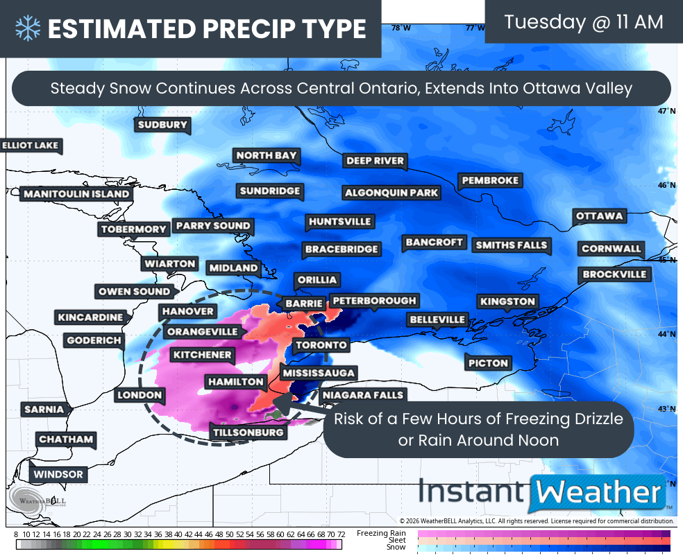
PRECIP TYPE - MAP FROM WEATHERBELL
By the late morning hours, steady snow is expected to overspread much of Eastern Ontario, including Kingston and extending northward into the Ottawa Valley. Snowfall rates are expected to gradually increase through the afternoon as the system strengthens while pushing east.
At the same time, we continue to monitor the risk of mixed precipitation further west. Some models are indicating a narrow zone where warmer air aloft could allow freezing rain, freezing drizzle or even ice pellets to briefly mix in with the snow. The highest risk for this appears to be from London through Kitchener, Guelph and Hamilton, though it may extend north toward Barrie and east into York Region and parts of Toronto.
Confidence remains low on how much icing will occur and for how long. Most indications suggest this risk would be brief and taper off by early afternoon as the system continues east. Even so, any freezing rain could lead to icy road conditions, especially on untreated rural roads and side streets.
Hourly snowfall rates (cm) - MAP FROM WEATHERBELL
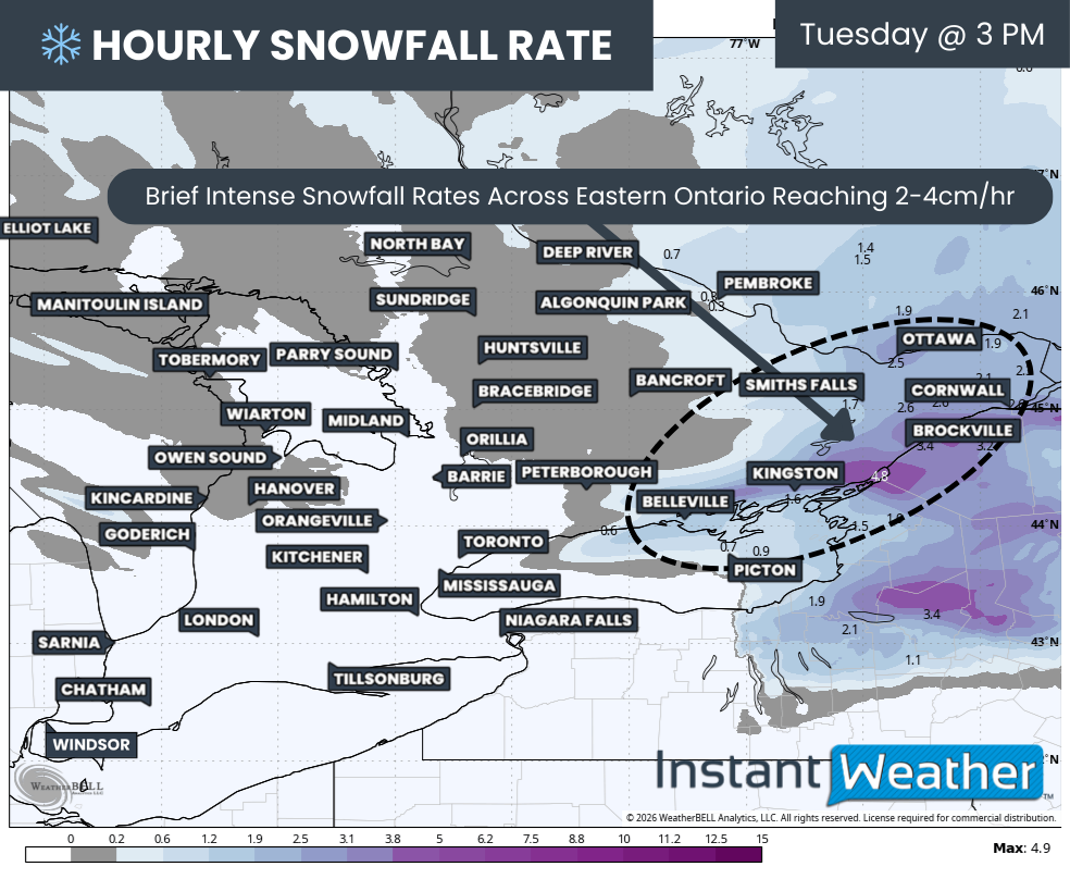
As we move into the afternoon, snow is expected to taper off from west to east across much of Southern Ontario. However, conditions may actually worsen further east as the system intensifies while moving into Eastern Ontario.
Some model data shows the potential for rapid intensification of snow bands across Eastern Ontario during the mid to late afternoon. In these scenarios, snowfall rates could briefly approach 4 to 5cm per hour for an hour or two. If that materializes, snow could pile up very quickly and lead to snow-covered roads just as the evening commute gets underway.
This raises concern for a particularly difficult evening commute through Kingston, Brockville and much of the Ottawa Valley, where travel conditions could deteriorate rapidly in a short period of time.
NOTE: YOU CAN CLICK ON THE MAP TO OPEN A ZOOMABLE IMAGE

When it comes to snowfall totals, this is shaping up to be one of those systems where there is fairly strong agreement across the models.
Most of Central and Eastern Ontario, extending into Northeastern Ontario, can expect general snowfall totals in the 10 to 15cm range by the time snow winds down Tuesday evening. This includes areas such as Ottawa, Cornwall, Brockville, Smiths Falls, Renfrew, Bancroft, Bracebridge, Huntsville, Algonquin Park, Parry Sound, North Bay, Sudbury and Elliot Lake.
We have opted to use a slightly broader forecast range of 10 to 20cm to account for the potential that the system overperforms in some areas. A few models continue to suggest totals creeping above 15cm in parts of Eastern Ontario, which would push localized amounts closer to the upper end of that range.
There is also a low but non-zero risk that isolated pockets could approach 25cm, particularly if intense snowfall rates linger over the same area for an extended period of time in Eastern Ontario. At this stage, totals above 20cm remain questionable and are not the most likely outcome.
Further south, snowfall totals are expected to be lower. These areas will likely sit south of the strongest precipitation bands, and temperatures closer to the freezing mark will also work against higher accumulations.
A zone stretching from the Bruce Peninsula through Owen Sound, Collingwood, Midland, Barrie, Orillia, Peterborough, Oshawa, Belleville and Kingston is expected to see around 5 to 10cm of new snow. There is a chance that the northern edge of this zone, particularly near Orillia and Peterborough, could see localized totals closer to 15cm if heavier bands shift slightly south.
Southern Grey Bruce, Kitchener, Guelph and parts of the western GTA are expected to see less than 5cm of snow overall. However, these areas carry the highest risk for freezing rain, with up to 2mm of ice accretion possible during the late morning period.
Deep Southwestern Ontario, including London and extending into the Niagara region, is expected to see little to no snow from this system. Temperatures here may briefly rise above the freezing mark on Tuesday, making regular rain the most likely precipitation type for much of the event.
We will continue to refine the forecast as higher resolution guidance comes into range, especially with regards to the freezing rain risk and the potential for intense snowfall rates in Eastern Ontario. Stay tuned for updates as we get closer to Tuesday.


