Snow Squalls Threaten Parts of Ontario Tuesday Into Wednesday; Locally Up to 25cm of Snow Possible

NOTE: YOU CAN CLICK ON THE MAP TO OPEN A ZOOMABLE IMAGE

While Southern Ontario has largely been spared significant snowfall this season, the lake effect snow machine is in full swing around Georgian Bay, Lake Huron, and Superior. The week began with heavy bursts of snow east of Lake Huron and along Georgian Bay's southern shoreline.

The focus now shifts northward, as a westerly flow initiates snow squalls late Tuesday, impacting areas east of Georgian Bay and adding to the squalls east of Lake Superior from Tuesday afternoon.


GOOGLE AD (NOT ENDORSED BY INSTANT WEATHER)

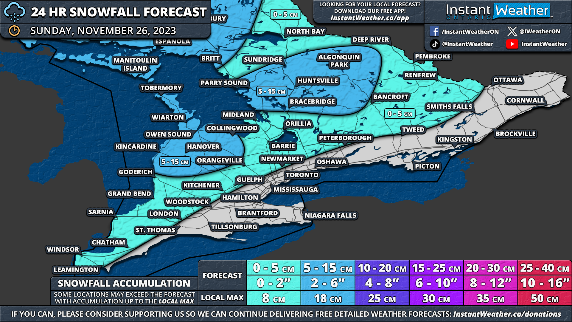
By Wednesday afternoon, when the lake effect activity subsides, some areas could see 15-25cm of snow. These higher totals will be highly localized, depending on the squalls' exact positions. Even a slight wind shift could mean the difference between 0 or 25+ cm of snow.

Overnight into Wednesday, Parry Sound, Muskoka, and Northern Simcoe County will likely experience heavy snow and near-zero visibility. The snow bands could extend quite far inland, potentially affecting Haliburton and Kawartha Lakes, especially Wednesday morning. Later Wednesday morning, an intense snow band may move south, briefly hitting Grey-Bruce, Barrie, and northern GTA areas between 10 AM and 2 PM.

In the afternoon, a main squall off Lake Huron, near Port Elgin and Owen Sound, will stretch inland towards Shelburne and Orangeville. This is expected to dissipate by late afternoon but could reach parts of the GTA, possibly impacting the evening commute with a quick few centimetres of snow.


GOOGLE AD (NOT ENDORSED BY INSTANT WEATHER)

The heaviest snowfall, between 15-25cm, is anticipated between Bracebridge and Orillia, depending on the squall's location.

Data suggests multiple squalls may occur, with a northern squall from Britt to Burk’s Fall and southern squalls affecting Southern Muskoka and Northern Simcoe County.

With the intensity of the lake effect activity spread out between the multiple bands, this should moderate totals, preventing extreme accumulation in a small area. Consequently, larger area east of Georgian Bay will experience snow squall activity, with widespread totals of 10 to 25cm.

Around Lake Huron, significant squall activity isn't expected, except for a brief squall near Port Elgin and Owen Sound on Wednesday afternoon, bringing 5-10cm, locally up to 15cm.

Central Ontario, particularly around Lake Simcoe and the northern GTA, could see up to 5-10cm from Wednesday's squall. Other parts of Southern Ontario not on the map will likely receive less than 2cm.


GOOGLE AD (NOT ENDORSED BY INSTANT WEATHER)

NOTE: YOU CAN CLICK ON THE MAP TO OPEN A ZOOMABLE IMAGE

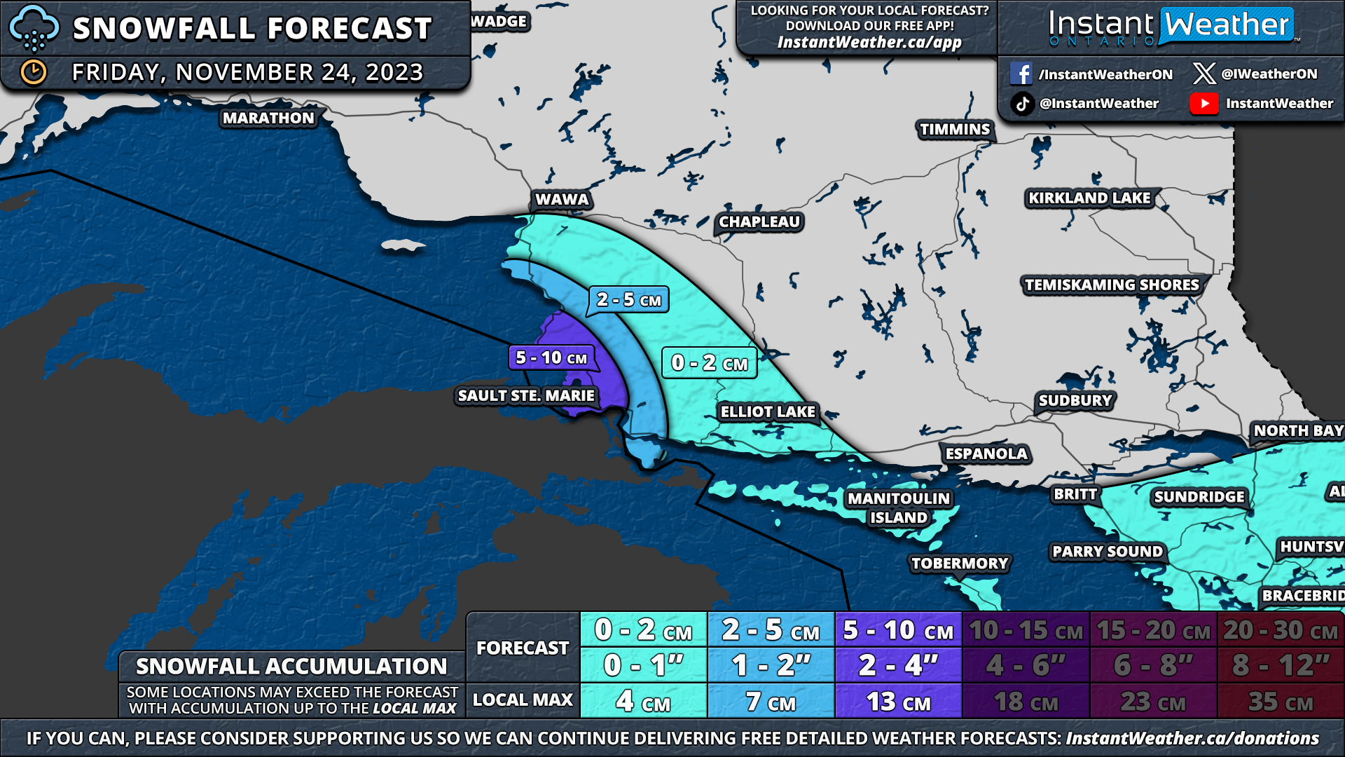
East of Lake Superior, lake-effect snow will persist this evening into the overnight between Wawa and Sault Ste. Marie. The squalls are expected to weaken Wednesday morning as wind direction shifts, ending the lake-effect snow.

Similar localized snowfall of 15-25cm is expected by Wednesday afternoon in the Sault Ste. Marie and Wawa area. Accumulation will decrease quickly away from Lake Superior's shoreline, though Elliot Lake could see up to 5-10cm from the inland-reaching squalls tonight.


GOOGLE AD (NOT ENDORSED BY INSTANT WEATHER)

Snow Squalls Return to Southern Ontario’s Snowbelt This Week With Up to 10-15cm of Snow by Late Monday

NOTE: YOU CAN CLICK ON THE MAP TO OPEN A ZOOMABLE IMAGE

December kicked off on a messy note with a winter storm bringing snow and prolonged freezing rain to parts of the Ottawa Valley. However, the last few days have treated us to record-breaking warmth, with many locations across Southern Ontario registering double-digit temperatures on Saturday.

This weather roller coaster is expected to persist as we enter the second week of December. This time, we anticipate more typical winter conditions, featuring a near-miss snowstorm in Eastern Ontario and a resurgence of lake-effect snow activity around Georgian Bay and Lake Huron.


GOOGLE AD (NOT ENDORSED BY INSTANT WEATHER)

There has been much discussion about a potential system this weekend that, at one point, seemed likely to bring significant wintry weather to parts of Southern Ontario.

While we've been closely monitoring it, the models presented too much uncertainty and disagreement to even attempt a forecast. It is now evident that this system will track far to the east, crossing over the US Northeast and into Quebec, where 15-30cm of snow is possible tonight and throughout Monday.

Recently, attention has focused on whether there might be slight adjustments to the west, potentially bringing heavy snowfall to parts of Eastern Ontario. As of now, this western track hasn't materialized in the models, and some have even shifted it further east.

We could still see a few centimetres of snow along the US border in Eastern Ontario, including Brockville and Cornwall, during the day on Monday. However, it will likely max out at around 5cm, possibly locally as much as 7cm, but that remains uncertain.


GOOGLE AD (NOT ENDORSED BY INSTANT WEATHER)

In addition to the system snow, we are closely monitoring the potential for disorganized lake-effect snow bands to develop off Georgian Bay and Lake Huron late Sunday evening. The heaviest lake-effect activity appears focused on the southeastern shoreline of Georgian Bay and Lake Huron.

Localized snow squalls will persist throughout Monday. While the activity is expected to remain fairly disorganized and spread out, even weak lake-effect snow has the potential to reduce visibility. Strong wind gusts between 30-50 km/h could cause blowing snow, so it's essential to drive according to the conditions!


GOOGLE AD (NOT ENDORSED BY INSTANT WEATHER)

NOTE: YOU CAN CLICK ON THE MAP TO OPEN A ZOOMABLE IMAGE

By the time the squalls fizzle out on Monday evening, the hardest-hit regions, including Collingwood, Wasaga Beach, Angus, Wingham, Goderich, Clinton, Mitchell, and Stratford, could see snowfall totals ranging from 5-10cm.

There's a possibility that a few localized totals could approach 15cm if the lake-effect bands are more intense than expected. However, this depends on the exact location of the squalls, and not everyone within the 5-10cm zone will see that much snow!

For surrounding regions southeast of Lake Huron and Georgian Bay, we anticipate up to 5cm of snow over the next 24 hours. Local totals could be slightly higher if the squall activity stretches further inland. Some light snow will move across northern parts of Central Ontario early Monday, leading to snowfall totals of around 2-5cm.

For the rest of Southern Ontario, expect a few brief bursts of lake-effect flurries throughout Monday, but it won't lead to any notable accumulation.


GOOGLE AD (NOT ENDORSED BY INSTANT WEATHER)

Southern Ontario Basks in Unusually Warm Temperatures With a Rare December Thunderstorm Risk on Saturday and Sunday

NOTE: YOU CAN CLICK ON THE MAP TO OPEN A ZOOMABLE IMAGE

Don't be surprised if you hear a few rumbles of thunder or catch a glimpse of lightning later today into Sunday morning.

Southern Ontario is currently experiencing an exceptionally warm weekend for December, with numerous areas reporting double-digit temperatures.

The hottest spots in all of Canada are presently Windsor and St. Catharines, both registering a temperature of 14.5 °C as of 12:50 PM on Saturday. Notably, this might set a temperature record for Windsor, considering the highest recorded temperature on this day is 14.4°C from 1946!


GOOGLE AD (NOT ENDORSED BY INSTANT WEATHER)

This warmer weather will lead to some instability later today, with scattered thunderstorms developing this afternoon. While the majority of these storms are expected to be relatively weak and not reach severe levels, the latest data suggests a questionable severe risk around Windsor and Chatham during the mid to late afternoon hours today.

An isolated storm could emerge over Michigan and track into the Windsor area in the next few hours. It's highly unlikely for any storms to become severe today, but we believe it's worth mentioning as it can't be entirely ruled out.

The main risks would be strong wind gusts, small hail, and heavy rainfall. Some parts of Southern Ontario could witness between 10-20mm of rainfall by Sunday morning.

This thunderstorm risk will persist to the northeast, affecting the Golden Horseshoe, Central, and Eastern Ontario later this evening and into the overnight hours.


GOOGLE AD (NOT ENDORSED BY INSTANT WEATHER)

You might have heard discussions about a significant storm over the last few days for Southern Ontario. We refrained from discussing it earlier, as models were inconsistent. Some models earlier this week suggested a widespread snowstorm with up to 50cm of snow in some parts of our region! However, that is no longer the case.

The latest model data indicates a potential snowmaker tracking up the US Northeast late Sunday into Monday. It seems that accumulating snow will likely miss Southern Ontario, but it's a close call. There's a possibility of heavier snow along the American border in Eastern Ontario (Brockville, Cornwall, etc.), but even that is uncertain.

Some lake-effect snow activity is also possible early this week around Lake Huron and Georgian Bay. We are monitoring the situation and will provide a comprehensive forecast later this weekend if necessary.


GOOGLE AD (NOT ENDORSED BY INSTANT WEATHER)

‘Snow/Ice Day’ Forecast: School Bus Cancellations Almost Certain on Monday in Eastern Ontario Due to Ongoing Winter Storm

NOTE: YOU CAN CLICK ON THE MAP TO OPEN A ZOOMABLE IMAGE


GOOGLE AD (NOT ENDORSED BY INSTANT WEATHER)

A winter storm is currently impacting a significant portion of Eastern and Central Ontario, and its effects are anticipated to persist into the overnight hours and early Monday morning. The storm is causing poor driving conditions, characterized by freezing rain throughout Sunday that is expected to transition into heavy snow later in the evening.

In response to these conditions, Environment Canada has issued a winter storm warning for specific areas in the Ottawa Valley, strongly advising against non-essential travel until conditions improve on Monday. Given the severity of the warning and the anticipated poor road conditions, it is highly likely that school bus cancellations will occur in Eastern Ontario.


GOOGLE AD (NOT ENDORSED BY INSTANT WEATHER)

The rural school boards surrounding the Ottawa region have a 90% likelihood of experiencing a 'snow/ice day' on Monday. Although Ottawa is expected to be similarly affected, the local school board tends to adhere to a more strict policy for cancelling school buses due to the generally better-maintained urban roads. We are forecasting a 75% chance for Ottawa, as we believe the conditions will still be severe enough to warrant cancellations.

Beyond Eastern Ontario, we do not anticipate widespread cancellations, as freezing rain in some areas is forecasted to come to an end by this evening, transitioning to wet snow with less than 10cm of accumulation possible.

Those in the Haliburton, Muskoka, and East Parry Sound regions have a 25% chance of experiencing a snow day. The likelihood decreases to 5-10% for the rest of Central Ontario, including Peterborough, Simcoe County, and areas northwest of the GTA.


Disclaimer: Instant Weather has zero authority when it comes to bus and school closures. It is completely up to the school boards, bus companies, local authorities, and parents to decide what is best for their children. This is our best guess based on our forecast.


GOOGLE AD (NOT ENDORSED BY INSTANT WEATHER)

Potential Winter Storm for Central and Eastern Ontario Including Ottawa; 15-25cm of Snow & Freezing Rain Starting Sunday

NOTE: YOU CAN CLICK ON THE MAP TO OPEN A ZOOMABLE IMAGE

While the winter weather season has been quite active in most of Southern Ontario over the past few weeks, Eastern Ontario has largely been spared from the worst of it. However, that streak of luck is about to change as the first significant winter storm is on the horizon, set to begin on Sunday.

Current data indicate that the Ottawa Valley may experience widespread snowfall totals ranging from 15 to 25cm between Sunday afternoon and Monday morning. There is even a possibility of some localized totals exceeding 25cm, though this is expected to be fairly isolated.

Central and Eastern Ontario are also facing the concern of freezing rain, with locally up to 5-10mm of ice accretion possible, while more widespread amounts will be closer to a few millimetres of ice.


GOOGLE AD (NOT ENDORSED BY INSTANT WEATHER)

The system responsible for this wintry mix is poised to move into our region early on Sunday, initially bringing a combination of freezing rain and snow to Central and Eastern Ontario. As the day progresses, it will transition into more sustained heavy snow, with the most challenging conditions anticipated late Sunday into early Monday morning.

There is also a possibility of freezing rain to the northwest of the Greater Toronto Area, particularly over the higher elevations of the Dundalk Highlands during Sunday morning and afternoon.

For Southwestern Ontario and the Lake Ontario shoreline, precipitation is expected to remain mostly rain throughout the event, with limited impact. However, there could be a transition to wet flurries overnight into Monday morning as the system moves out and colder air follows.

By the evening, freezing rain is likely to transition to heavy snow as colder air settles across the region. This brings the potential for rapid snowfall accumulation in the Ottawa Valley and northern parts of Central Ontario during the evening and early overnight hours.

Hourly snowfall rates might briefly approach 4-8cm at the peak of this event, coupled with 50-70km/h wind gusts, leading to blowing snow and near-zero visibility on roads. Travel is strongly discouraged starting late Sunday into early Monday. We will likely see some school bus cancellations on Monday morning.

Snowfall will persist into early Monday morning, gradually coming to an end by sunrise. Flurries are expected to linger throughout the morning, but significant accumulation is not anticipated.


GOOGLE AD (NOT ENDORSED BY INSTANT WEATHER)

NOTE: YOU CAN CLICK ON THE MAP TO OPEN A ZOOMABLE IMAGE

Regarding the freezing rain threat, there are two areas of concern with the heaviest freezing rain potential. The first is confined to the higher elevations around the Dundalk Highlands, including Orangeville and Shelburne.

Moving eastward, the freezing rain threat becomes more widespread, covering most of Eastern Ontario and Central Ontario. However, a quicker switch to snow may result in less actual ice accretion than initially forecast.


GOOGLE AD (NOT ENDORSED BY INSTANT WEATHER)

The highest ice accretion is expected southwest of Ottawa, including Smiths Falls, Bancroft, Kaladar, Arnprior, Orangeville, and Shelburne. This region could see up to 5-10mm of ice by the end of Sunday.

Those in Cornwall, Ottawa, and areas westward into Muskoka may experience a few millimetres of freezing rain primarily during the early part of Sunday before transitioning to heavy snow by Sunday evening.

A critical aspect of this event is its potential impact due to the absence of a substantial warm-up after the freezing rain, which could impede the melting of any ice that forms. Above-freezing temperatures may not return to the region until next weekend at the earliest, ensuring that the ice and snow will linger.

Compounding the situation, heavy snowfall is expected, raising the risk of power outages as accumulated ice and snow will weigh down power lines and tree branches.


GOOGLE AD (NOT ENDORSED BY INSTANT WEATHER)


The highest snowfall totals are expected along the Quebec border, including Hawkesbury, Ottawa, Arnprior, Renfrew, and Pembroke. Accumulation in this area is projected to range from 15 to 25cm, with the potential for a few locations to exceed 25cm, particularly over the higher elevations west of Ottawa.

A zone extending from Cornwall through Smiths Falls and into Bancroft can expect around 10-20cm of snow from this storm. This region, experiencing the worst freezing rain impact, may be one of the hardest-hit areas from the combined effects of ice and snow.


GOOGLE AD (NOT ENDORSED BY INSTANT WEATHER)

To the west, widespread totals ranging from 5 to 10cm are expected, extending from Eastern Ontario westward to areas around Lake Simcoe and Georgian Bay. Some models suggest possible lake enhancement off Georgian Bay, leading to locally higher totals of up to 15cm in parts of Simcoe County and Muskoka.

Less than 5cm of snow is anticipated around the Lake Ontario shoreline and in Southwestern Ontario, where precipitation will primarily be in the form of rain. Rain accumulation is expected to range from 5-15mm, with some areas around Lake Ontario, including Toronto eastward into Kingston, possibly seeing up to 15-25mm.

Snowy Start to the Weekend for Southern Ontario With Up to 5-10cm of Snow Late Friday Into Saturday

NOTE: YOU CAN CLICK ON THE MAP TO OPEN A ZOOMABLE IMAGE

December has arrived, and Mother Nature is swiftly ushering in winter across Southern Ontario. Earlier this week, we witnessed the first significant lake-effect event of the season, blanketing parts of the snowbelt region around Lake Huron and Georgian Bay with over 30cm of snow.

As we step into the first weekend of December, it is set to begin on a snowy note for much of Central and Eastern Ontario, courtesy of a system tracking across the region today into Saturday. Precipitation has already started in the southwest part of the province and is anticipated to persist throughout the evening and into Saturday morning.


GOOGLE AD (NOT ENDORSED BY INSTANT WEATHER)

For Southwestern Ontario and the Golden Horseshoe area, we anticipate predominantly rain persisting intermittently over the next 24 hours. However, we could see some wet flurries mixed in around parts of the GTA. Total rainfall accumulation is projected to range from 5 to 15mm.

The focus of the weather story shifts northward, especially across the higher elevations of the Dundalk Highlands into Central and Eastern Ontario. These areas have already seen some wet flurries this afternoon which is expected to intensify later in the day and overnight.

This snowfall won’t be excessively heavy, with more prolonged steady, light to moderate snowfall throughout the evening and overnight hours, stretching from Georgian Bay through Central Ontario into the Ottawa Valley. It will gradually subside just after sunrise and should conclude around the noon hour.

There's also a potential risk of freezing drizzle to the northwest of the GTA, encompassing Orangeville and Shelburne overnight. However, its impact is likely to be insignificant, and not every model supports this scenario.


GOOGLE AD (NOT ENDORSED BY INSTANT WEATHER)

The highest snowfall accumulation from this event is expected to be between 5 and 10cm by Saturday afternoon. This encompasses regions such as Orangeville, Barrie, Muskoka, Bancroft, Renfrew, and Pembroke. While most locations are likely to fall closer to the 5cm mark, a few localized areas could approach or even exceed 10cm.

Ottawa, Peterborough, Newmarket, Guelph, and Kincardine may experience a few centimetres of snow, while the rest of Southern Ontario anticipates less than 2cm, with wet flurries possible around the Lake Ontario shoreline into the Kitchener region.


GOOGLE AD (NOT ENDORSED BY INSTANT WEATHER)

‘Snow Day’ Forecast: Continued Snow Squall Risk Brings Third Day of Possible School Bus Cancellations on Wednesday in Parts of Central Ontario

NOTE: YOU CAN CLICK ON THE MAP TO OPEN A ZOOMABLE IMAGE


GOOGLE AD (NOT ENDORSED BY INSTANT WEATHER)

Snow squalls are expected to return to regions east of Georgian Bay and Grey-Bruce overnight and Wednesday morning. These bands of snow will bring reduced visibility leading to poor road conditions throughout the Parry Sound and Muskoka regions.

School bus cancellations are very likely on Wednesday with a 75% chance for Parry Sound and Muskoka. We considered going with a 90% chance, but it’s uncertain how strong the activity will be during the morning hours.


GOOGLE AD (NOT ENDORSED BY INSTANT WEATHER)

There is a 50% chance for Northern Simcoe County along with the Bruce Peninsula which may also be affected by the lake effect snow at times tomorrow.

Away from those particular regions, the chance of a snow day is fairly limited with 25% or less of a chance for the rest of Grey-Bruce and areas around Lake Simcoe. We don’t expect any bus cancellations in Deep Southwestern Ontario or around the Golden Horseshoe as this will be contained to the snowbelt around Lake Huron and Georgian Bay.


Disclaimer: Instant Weather has zero authority when it comes to bus and school closures. It is completely up to the school boards, bus companies, local authorities, and parents to decide what is best for their children. This is our best guess based on our forecast.


GOOGLE AD (NOT ENDORSED BY INSTANT WEATHER)

Snow Squall Threat Continues Into Wednesday in Parts of Southern Ontario With an Additional 10 to 20cm of Snow Possible

NOTE: YOU CAN CLICK ON THE MAP TO OPEN A ZOOMABLE IMAGE

It has been an active start to the week around Lake Huron and Georgian Bay, with intense snow squall activity bringing significant snowfall accumulation and near-zero visibility.

Some locations have already witnessed upwards of 20-30cm of snow over the last two days, with the anticipation of snow squalls to drift back north to regions east of Lake Huron and Georgian Bay late Tuesday. Another day of snow squalls is expected on Wednesday; however, they won't be as intense as Tuesday’s squalls and will affect areas further north.

Additional snowfall over the next 24 hours, between Tuesday and Wednesday evening, could range from 10-20cm in the hardest-hit regions. As some locations have already seen 20-30cm of snow from earlier squalls, overall snowfall totals since Sunday could approach 30-40cm!


GOOGLE AD (NOT ENDORSED BY INSTANT WEATHER)

The main snow squall band of Lake Huron currently stretches from Goderich through Perth County and into the Woodstock area. Meanwhile, the Georgian Bay squall is hammering the Wasaga Beach, Barrie, and Keswick areas.

This will persist for a few more hours into the early evening before we expect a shift in the wind direction to a more westerly to southwesterly flow overnight.

As the winds shift, this will cause the snow squall activity to drift northwards, with the Lake Huron squall moving into the Grey-Bruce region and the Georgian Bay squall targeting the Muskoka and Parry Sound regions.

Expect poor driving conditions mainly east of Georgian Bay, along with the Bruce Peninsula throughout the morning on Wednesday. Another day of school bus cancellations is likely due to rapid snowfall accumulation and reduced visibility.


GOOGLE AD (NOT ENDORSED BY INSTANT WEATHER)

It appears that the snow squalls on Wednesday will be somewhat more disorganized compared to what we saw from Monday evening into Tuesday. A wide swath of the eastern shoreline of Georgian Bay from Sundridge down to Gravenhurst will experience moderate to heavy snow into Wednesday afternoon.

By Wednesday afternoon, the activity could briefly become more organized into what could be a strong squall stretching from Parry Sound into the North Bay region, although it likely will only last for a few hours. Scattered lake-effect snow will continue throughout the rest of Wednesday, tapering off fully by the evening.

Due to the shift in wind direction, there could be a heavy burst of snow across the GTA and Eastern Ontario late Wednesday as the remnants of the snow squalls slide to the southeast. This won’t have much of a significant impact but could bring a fresh dusting of snow.


GOOGLE AD (NOT ENDORSED BY INSTANT WEATHER)

NOTE: YOU CAN CLICK ON THE MAP TO OPEN A ZOOMABLE IMAGE

While the more spread-out lake-effect activity will help avoid any major accumulation in a focused region, this will result in a larger area seeing some notable accumulation over the next 24 hours.

General snowfall totals should end up between 10 to 20cm in regions including the Bruce Peninsula, Owen Sound, Hanover, Kincardine, Wingham, Listowel, Parry Sound, and Muskoka. It’s possible a few areas could approach 25cm in localized pockets. This is on top of the previous snowfall from the last two days in these areas.

Surrounding regions inland from Lake Huron and Georgian Bay can expect around 5-10cm of additional snowfall, with perhaps as much as 15cm in localized areas. Keep in mind that this is less certain as it will depend on the exact strength and location of the snow squalls.

Less than 5cm is expected for the rest of Southern Ontario, with most of that coming late Wednesday as the decaying snow squall slides through.


GOOGLE AD (NOT ENDORSED BY INSTANT WEATHER)


Snow squalls are also expected to return to areas southeast of Lake Superior by Tuesday evening and continue through Wednesday. The hardest-hit area appears to be the corridor between Wawa and Sault Ste. Marie. Between 10 to 20cm of snow is possible by the end of Wednesday.

Further north, a weak system will slide across Northwestern Ontario late Wednesday, bringing up to 5-10cm of snow to areas around Thunder Bay and to the northwest towards the Manitoba border.


GOOGLE AD (NOT ENDORSED BY INSTANT WEATHER)

‘Snow Day’ Forecast: School Buses Will Likely Be Cancelled Across Central and Southwestern Ontario on Tuesday Due to Intense Snow Squalls

NOTE: YOU CAN CLICK ON THE MAP TO OPEN A ZOOMABLE IMAGE


GOOGLE AD (NOT ENDORSED BY INSTANT WEATHER)

UPDATE

Confidence is growing in widespread school bus cancellations across Central and Southwestern Ontario. Intense snow squalls have developed resulting in an expansive snow squall warning from Environment Canada.

We have increased the chances for Muskoka due to expected significant snowfall of up to 50cm by morning. Other areas further inland from Lake Huron including Kitchener, Guelph and York Region have been added to the snow squall warning. We have pumped those regions up to a 50% chance.


Earlier update

Anticipate intense snow squall activity tonight into Tuesday morning around Lake Huron and Georgian Bay, resulting in rapid snowfall accumulation and blizzard-like conditions in affected regions.

Significant travel disruptions are expected, prompting Environment Canada to issue a snow squall warning advising, 'Consider postponing non-essential travel until conditions improve.'

Given this, it's highly likely that school boards will opt to cancel school buses on Tuesday across a broad swath of Central and Southwestern Ontario, with the potential for some school closures.

The highest likelihood of a 'snow day' extends from Grey-Bruce to Simcoe County, where there's a 90% chance of school bus cancellations. Ongoing snow squalls throughout the morning will create challenging travel conditions, possibly leading to road closures.


GOOGLE AD (NOT ENDORSED BY INSTANT WEATHER)

In Muskoka and Kawartha Lakes, there's a 75% chance, although confidence is lower as the most severe conditions tomorrow morning are expected closer to the southeastern shoreline of Georgian Bay.

A 75% chance of school bus cancellations is also projected for the Goderich and Listowel area, primarily due to Environment Canada currently having a watch in effect for those regions. If upgraded to a warning by evening, the likelihood may increase to 90%.

The probability of a snow day diminishes further from Lake Huron and Georgian Bay. Peterborough, Northern Durham, York, Dufferin, Wellington, K/W, and areas north of London face a 25-50% chance, as squalls could extend far inland under conducive conditions, resulting in reduced visibility and potential bus cancellations.

Eastern Ontario, along with the GTA and Deep Southwestern Ontario, has less than a 10% chance of a snow day.

Stay tuned for our finalized forecast this evening!


Disclaimer: Instant Weather has zero authority when it comes to bus and school closures. It is completely up to the school boards, bus companies, local authorities, and parents to decide what is best for their children. This is our best guess based on our forecast.


GOOGLE AD (NOT ENDORSED BY INSTANT WEATHER)

[PREVIEW] ‘Snow Day’ Forecast: Widespread School Bus Cancellations Expected on Tuesday in Parts of Southern Ontario Due to Significant Snow Squalls

NOTE: YOU CAN CLICK ON THE MAP TO OPEN A ZOOMABLE IMAGE

THIS IS A PRELIMINARY FORECAST AND MAY CHANGE WITH OUR FINAL FORECAST. THE MAP WILL BE FINALIZED EARLY IN THE EVENING.


GOOGLE AD (NOT ENDORSED BY INSTANT WEATHER)

Anticipate intense snow squall activity tonight into Tuesday morning around Lake Huron and Georgian Bay, resulting in rapid snowfall accumulation and blizzard-like conditions in affected regions.

Significant travel disruptions are expected, prompting Environment Canada to issue a snow squall warning advising, 'Consider postponing non-essential travel until conditions improve.'

Given this, it's highly likely that school boards will opt to cancel school buses on Tuesday across a broad swath of Central and Southwestern Ontario, with the potential for some school closures.

The highest likelihood of a 'snow day' extends from Grey-Bruce to Simcoe County, where there's a 90% chance of school bus cancellations. Ongoing snow squalls throughout the morning will create challenging travel conditions, possibly leading to road closures.


GOOGLE AD (NOT ENDORSED BY INSTANT WEATHER)

In Muskoka and Kawartha Lakes, there's a 75% chance, although confidence is lower as the most severe conditions tomorrow morning are expected closer to the southeastern shoreline of Georgian Bay.

A 75% chance of school bus cancellations is also projected for the Goderich and Listowel area, primarily due to Environment Canada currently having a watch in effect for those regions. If upgraded to a warning by evening, the likelihood may increase to 90%.

The probability of a snow day diminishes further from Lake Huron and Georgian Bay. Peterborough, Northern Durham, York, Dufferin, Wellington, K/W, and areas north of London face a 25-50% chance, as squalls could extend far inland under conducive conditions, resulting in reduced visibility and potential bus cancellations.

Eastern Ontario, along with the GTA and Deep Southwestern Ontario, has less than a 10% chance of a snow day.

Stay tuned for our finalized forecast this evening!


Disclaimer: Instant Weather has zero authority when it comes to bus and school closures. It is completely up to the school boards, bus companies, local authorities, and parents to decide what is best for their children. This is our best guess based on our forecast.


GOOGLE AD (NOT ENDORSED BY INSTANT WEATHER)

‘Snow Day’ Forecast: Snow Squalls on Monday Likely to Cancel School Buses in Parts of Central Ontario

NOTE: YOU CAN CLICK ON THE MAP TO OPEN A ZOOMABLE IMAGE


GOOGLE AD (NOT ENDORSED BY INSTANT WEATHER)

Snow squalls are anticipated to form off Georgian Bay early Monday morning, ushering in bands of heavy snowfall and diminished visibility for the Parry Sound and Muskoka region throughout the day.

Consequently, there is a likelihood of school bus cancellations in the affected areas, with a 75% probability for the Parry Sound region and a 50% chance for Muskoka and the Bruce Peninsula.

The higher probability for Parry Sound is attributed to the school board covering that region, which is known to be more responsive to weather conditions, giving us greater confidence in the likelihood of cancellations.

Presently, only a snow squall watch is in effect from Environment Canada. This alone is generally insufficient to trigger cancellations. However, if upgraded to a warning by morning, the probability of cancellations will significantly rise.


GOOGLE AD (NOT ENDORSED BY INSTANT WEATHER)

The Kincardine, Southampton, Owen Sound, and Simcoe County area will likely need to wait until Tuesday for a potential 'snow day'. Snow squall activity for these regions is not expected until Monday evening, making cancellations on Monday unlikely.

For the rest of Southern Ontario, the likelihood of school bus cancellations is minimal, with less than a 10% chance. The impact of this event is anticipated to be confined to regions around Lake Huron and Georgian Bay.


Disclaimer: Instant Weather has zero authority when it comes to bus and school closures. It is completely up to the school boards, bus companies, local authorities, and parents to decide what is best for their children. This is our best guess based on our forecast.


GOOGLE AD (NOT ENDORSED BY INSTANT WEATHER)

Snow Squalls Could Bring ‘Blizzard-like’ Conditions and Bury Parts of Ontario in Up to 50cm of Snow Between Sunday and Tuesday

NOTE: YOU CAN CLICK ON THE MAP TO OPEN A ZOOMABLE IMAGE

Confidence is growing in a significant snow squall threat to kick off the week in the regions around Lake Huron, Georgian Bay, and Lake Superior. Snow squall activity is anticipated to start as early as Sunday evening and persist through Monday into Tuesday.

These squalls will bring the potential for rapid snowfall accumulation, with hourly rates reaching 5-10cm. Combined with strong wind gusts, it is likely to result in blowing snow, possibly even leading to localized blizzard-like conditions.

Road closures are likely, especially late Monday into Tuesday morning when the most severe conditions are expected. The highest impact from this snow squall event will extend through the corridors from Owen Sound to Goderich and Orillia to Huntsville. For Northern Ontario, the Sault Ste. Marie and Wawa area will bear the brunt of the snow squalls off Lake Superior.

Total snowfall accumulation over the next few days will be highly variable, depending on the precise location of narrow yet intense bands of lake-effect snow. These bands are expected to shift around, limiting extreme totals but affecting a wider area at some point over the next 3 days.

Combined snowfall accumulation by Tuesday evening could approach 40-50cm in localized areas. General totals throughout the typical snowbelt region will range from 15 to 30cm.


GOOGLE AD (NOT ENDORSED BY INSTANT WEATHER)

SUNDAY

NOTE: YOU CAN CLICK ON THE MAP TO OPEN A ZOOMABLE IMAGE

This multi-day snow event begins Sunday evening as a messy system is currently tracking across the province. For most of Southern Ontario, precipitation has been a mixed bag, including rain, freezing rain, ice pellets, and wet snow throughout the afternoon and evening.

Limited snowfall accumulation is expected on Sunday, except for areas east of Lake Huron and Georgian Bay. Lake enhancement could boost snowfall totals to 5-10cm (locally 15cm) by nightfall for the Grey-Bruce, Parry Sound, and Muskoka regions.


GOOGLE AD (NOT ENDORSED BY INSTANT WEATHER)

NOTE: YOU CAN CLICK ON THE MAP TO OPEN A ZOOMABLE IMAGE

Northeastern Ontario will also see some notable snowfall accumulation, with widespread accumulation of 10-15cm by Sunday's end. A small zone east of Lake Superior between Wawa and Sault Ste. Marie could experience higher totals of up to 20-25cm due to evening snow squalls.


GOOGLE AD (NOT ENDORSED BY INSTANT WEATHER)

MONDAY

NOTE: YOU CAN CLICK ON THE MAP TO OPEN A ZOOMABLE IMAGE

The lake effect snow machine ramps up early Monday with squalls developing off Lake Huron and Georgian Bay. There's model disagreement on the exact squall direction, but a westerly flow is expected initially.

The lake-effect snow will likely be disorganized and spread out initially, with bands developing across Lake Huron, crossing the Bruce Peninsula and Georgian Bay before coming onshore between Parry Sound and Port Severn.

This continues into the afternoon, with activity becoming more focused, affecting parts of Muskoka and Parry Sound. The location of the strongest squall is unclear, with one model suggesting Parry Sound to Huntsville, while another places it further south, focusing on the Port Carling and Bracebridge region.


GOOGLE AD (NOT ENDORSED BY INSTANT WEATHER)

Local snowfall amounts by Monday's end could range from 15 to 25cm, although the localized nature of these squalls means not everyone will see that much snow. Bracebridge, Port Carling, Port Sydney, Rosseau, Huntsville, and Parry Sound are included.

Additional lake effect activity is expected east of Lake Huron, with heavier snow away from the shoreline. Locally, 10-15cm, possibly even 20cm, is possible in Listowel, Hanover, and Chatsworth.


NOTE: YOU CAN CLICK ON THE MAP TO OPEN A ZOOMABLE IMAGE


Sault Ste. Marie will likely face snow squalls starting early Monday and lasting throughout the day. Local amounts could approach 20cm in the hardest-hit regions by Monday's end.


GOOGLE AD (NOT ENDORSED BY INSTANT WEATHER)

TUESDAY

NOTE: YOU CAN CLICK ON THE MAP TO OPEN A ZOOMABLE IMAGE

A shift in wind direction late Monday will cause the snow squalls to sink southward overnight into early Tuesday, intensifying further. The worst conditions are expected during the pre-dawn hours on Tuesday, with blizzard-like conditions making travel near impossible throughout a big chunk of the snowbelt east of Lake Huron and southeast of Georgian Bay.

The squalls become stationary again by late Tuesday morning, with one main squall off Georgian Bay and coming onshore somewhere between Orillia and Barrie. This squall may stretch far inland, bringing heavy snow to parts of the Kawartha Lakes and the northern Durham region.

Two main squalls off Lake Huron will be present, with the more northern band stretching from Port Elgin inland towards Hanover and Shelburne. Further south, a secondary squall will come onshore between Point Clarke and Goderich, stretching into the Listowel and Mitchell area.


GOOGLE AD (NOT ENDORSED BY INSTANT WEATHER)

Again, the overall accumulation will depend on exactly where these bands lock-in, but the heaviest snowfall will likely be found in locations including Point Clark, Wingham, Listowel, Port Elgin, Hanover, Wasaga Beach, Midland, and Port Severn by Tuesday's end. These areas have the potential for snowfall totals ranging from 20 to 30cm, with locally higher amounts not out of the question.

Surrounding regions east of Lake Huron and around Lake Simcoe can expect 10 to 25cm, depending on the squalls' location and how far they stretch inland. Even parts of the Greater Toronto Area (GTA), particularly in the west end, could see a quick 5-10cm with the snow squalls off Lake Huron.

The Tuesday forecast should be considered preliminary as we await developments on Monday. Adjustments might be necessary as more higher-resolution model data become available.

Snow squalls may persist into Wednesday, although it's unclear which regions could be affected; this will be covered in a separate forecast.


GOOGLE AD (NOT ENDORSED BY INSTANT WEATHER)

OVERALL IMPACT

NOTE: YOU CAN CLICK ON THE MAP TO OPEN A ZOOMABLE IMAGE

With the snow squalls expected to shift over the next few days, extreme accumulation usually associated with stationary squalls is less likely. However, this will allow for a more widespread impact as the snow is more spread out.

An expansive zone east of Lake Huron from Owen Sound to Listowel could see 3-day snowfall totals between 25-40cm, locally up to 50cm. The story is similar to the eastern shoreline of Georgian Bay, with Parry Sound, Muskoka, and Northern Simcoe County in the bullseye.

Away from these areas, expected accumulation drops off rapidly, subject to more uncertainty depending on how far inland the squalls extend.

Around 15 to 30cm is possible for locations including Goderich, Stratford, Wiarton, Meaford, Barrie, Orillia, Lindsay, and Haliburton. Regions just west of the Golden Horseshoe, including Kitchener, Guelph, and Brantford, could see locally up to 10-20cm if the snow squall activity reaches them.

Again, not everyone will see significant totals, and some may not see any snow, given the extremely localized nature of these bands. It's challenging to pinpoint exactly where the squalls will end up.

Less than 5cm of snow is expected for most of the Golden Horseshoe, Eastern Ontario, and Deep Southwestern Ontario throughout the next 3 days.


GOOGLE AD (NOT ENDORSED BY INSTANT WEATHER)

NOTE: YOU CAN CLICK ON THE MAP TO OPEN A ZOOMABLE IMAGE

In Northern Ontario, widespread snowfall totals between 10-20cm are expected on Sunday night and Monday.

More intense snowfall is expected along the eastern shoreline of Lake Superior, with 25-40cm possible between Wawa and Sault Ste. Marie due to expected snow squall activity on Monday.

First Strong Snow Squall Event of the Season Could Bring Significant Snowfall to Parts of Southern Ontario Starting Sunday

NOTE: YOU CAN CLICK ON THE MAP TO OPEN A ZOOMABLE IMAGE

Winter is settling in across Ontario as we approach the end of November, and early next week marks the arrival of the coldest air so far this season, featuring temperatures well below the freezing mark.

By Tuesday, some parts of Northern Ontario, as well as the northern sections of Southern Ontario, could experience double-digit negative temperatures, even before factoring in the wind chill.


GOOGLE AD (NOT ENDORSED BY INSTANT WEATHER)

This frigid blast of cold air is triggering what appears to be a robust lake effect snow event in the traditional snowbelt region around Lake Huron, Lake Superior, and Georgian Bay. Locally intense snow squalls are anticipated to develop from Sunday evening, persisting through Monday and into Tuesday.

A potential secondary round of snow squalls may emerge starting Wednesday, though the exact location and intensity remain uncertain, which will be covered in a separate forecast in the coming days.

While still a few days away, most models are converging on a general consensus regarding the hardest-hit regions of these squalls, primarily driven by a northwesterly flow. However, variations in expected accumulation will become clearer as higher-resolution models come into view.

On Sunday, a weak system is forecasted to track through Southern Ontario, bringing some flurries and mixed precipitation across the region. Nevertheless, any snowfall accumulation is expected to be minor, with only a few centimetres possible.

As the system exits the region by late Sunday, colder air from the north will usher in lake-effect snow off Georgian Bay and Lake Huron as early as Sunday evening. Initially disorganized, the lake effect activity is likely to focus on areas northeast of the lake, with the Bruce Peninsula and Parry Sound region experiencing locally heavy snow.

By Monday morning, the lake effect snow will shift southward, intensifying as the environment becomes more favourable for snow squalls.


GOOGLE AD (NOT ENDORSED BY INSTANT WEATHER)

Current indications suggest two distinct squalls, with one stretching across the Bruce Peninsula, over Georgian Bay and coming onshore between Barrie and Orillia. A secondary squall is expected further south, predominantly affecting the Port Elgin, Owen Sound, Hanover, and Kincardine regions.

There is potential for these squalls to persist for up to 12-16 hours starting Monday afternoon and continuing into Tuesday morning. The exact location of the squalls is challenging to pinpoint at this stage, dependent on wind direction, strength, and temperature. If they lock in place, locally intense snowfall rates may lead to rapid accumulation and hazardous road conditions due to near-zero visibility, accompanied by blowing snow.

The snow squalls may continue into Tuesday, with the most intense conditions likely between Monday evening and Tuesday morning, gradually improving throughout the day. A shift in wind direction by Tuesday evening may temporarily halt the lake effect, but squalls could return overnight into Wednesday, focusing on regions southeast of Lake Huron, including Grand Bend and even London.


GOOGLE AD (NOT ENDORSED BY INSTANT WEATHER)

NOTE: YOU CAN CLICK ON THE MAP TO OPEN A ZOOMABLE IMAGE

We've outlined a rough idea of where the worst impacts from the lake effect snow are expected between Monday and Tuesday. Please note that this is preliminary, and the forecast zones will be refined in the coming days as higher-resolution models become available.

Regions in the strong impact zone include Port Elgin, Chatsworth, Owen Sound, Hanover, Flesherton, Midland, and Simcoe County. Some locations within this zone could see hefty snowfall totals approaching 25 or even 50cm.

The rest of the regions east of Lake Huron and Georgian Bay can expect a moderate impact from snow squall activity, with up to 25cm of snow possible. The Georgian Bay squall may extend quite far inland at times, affecting parts of Durham region and Kawartha Lakes.

While lake effect activity off Lake Ontario and Erie is expected to remain mostly stateside, it could briefly drift north late Tuesday, leading to heavy snow in the southern part of the Niagara region and Prince Edward County. Locally, 5-10cm of snow is possible within a few hours.


GOOGLE AD (NOT ENDORSED BY INSTANT WEATHER)


Turning our attention to Northern Ontario, snow squall activity off Lake Superior is anticipated to be relatively weaker than those off Georgian Bay and Lake Huron. However, we could still see up to 25cm throughout the Sault Ste. Marie and Wawa area, primarily on Sunday and early Monday.


GOOGLE AD (NOT ENDORSED BY INSTANT WEATHER)

‘Snow Day’ Forecast: Snow Squalls Bring a Slight Chance of School Bus Cancellations on Friday

NOTE: YOU CAN CLICK ON THE MAP TO OPEN A ZOOMABLE IMAGE


GOOGLE AD (NOT ENDORSED BY INSTANT WEATHER)

NOTE: Some school boards have a PA Day on Friday. Please disregard this forecast if your school board already has the day off.

Lake-effect activity and localized snow squalls are anticipated to impact regions around Lake Huron and Georgian Bay starting Thursday night. This could result in challenging road conditions on Friday morning, characterized by blowing snow and near-zero visibility, potentially leading to school bus cancellations.

The overall intensity of these snow squalls remains uncertain, casting doubt on the likelihood of school bus cancellations. This is especially true given the current status of a winter weather travel advisory issued by Environment Canada. If this advisory is upgraded to a snow squall warning by morning, the probability of bus cancellations will rise.


GOOGLE AD (NOT ENDORSED BY INSTANT WEATHER)

We have assigned a 25% chance of school bus cancellations to regions directly northeast of Lake Huron, including Kincardine and Southampton, as well as the west zone of Simcoe County.

It's worth noting that we are aware of a PA Day in Kincardine and Southampton, but for consistency, we provide this forecast assuming all school boards are open tomorrow.

Surrounding school boards, encompassing the rest of Grey-Bruce and Simcoe County, carry a 10% chance of school bus cancellations. The remainder of Southern Ontario has a probability of less than 10% for weather-related school bus cancellations on Friday.


Disclaimer: Instant Weather has zero authority when it comes to bus and school closures. It is completely up to the school boards, bus companies, local authorities, and parents to decide what is best for their children. This is our best guess based on our forecast.


GOOGLE AD (NOT ENDORSED BY INSTANT WEATHER)

Snow Squalls Could Bring Over 10cm of Snow to Parts of Ontario’s Snowbelt on Friday

NOTE: YOU CAN CLICK ON THE MAP TO OPEN A ZOOMABLE IMAGE

The chill is set to descend upon Ontario to wrap up the week, heralding the return of lake-effect snow in the traditional snowbelt on Friday. Some regions surrounding Lake Huron, Superior, and Georgian Bay could experience accumulations of over 10cm from the snow squall activity before it diminishes late Friday.


GOOGLE AD (NOT ENDORSED BY INSTANT WEATHER)

Lake-effect snow has already materialized off Lake Superior in Northern Ontario as of Thursday evening, accompanied by temperatures well below freezing. This trend is expected to persist overnight and into Friday, primarily affecting areas southeast of the lake, including Sault Ste. Marie.

Heading further south, temperatures are still above the freezing point, but this is anticipated to change in the coming hours. Lake-effect snow is expected to commence around midnight, likely remaining relatively unorganized for much of the night.

Current indications suggest the heaviest snowfall will be concentrated in Grey, Bruce, and Simcoe counties, with the activity becoming more organized by early Friday morning. Localized snow squalls are expected to persist throughout the morning and afternoon hours.

The Lake Huron squall is projected to come onshore around Point Elgin and extend inland towards Hanover, while the Georgian Bay squall will focus on the Wasaga Beach, Barrie, and Angus areas. However, it may extend into parts of the Northern Greater Toronto Area (GTA) at times.

Activity off Lake Superior should taper off by late Friday afternoon. However, around Lake Huron and Georgian Bay, lake-effect snow may linger into the evening and potentially even early Saturday morning before tapering off just after midnight. The most intense activity is expected during the morning and afternoon.


GOOGLE AD (NOT ENDORSED BY INSTANT WEATHER)

NOTE: YOU CAN CLICK ON THE MAP TO OPEN A ZOOMABLE IMAGE

As is typical with a lake-effect event, snowfall totals will vary considerably, depending on the exact placement of the squalls and their duration over a particular area. Our forecast predicts a general 5-10cm in locations including Port Elgin, Chatsworth, Hanover, Wasaga Beach, Angus, and Barrie.

There's potential for a few localized regions to accumulate up to 15cm, as one model, in particular, is aggressive with squall intensity. Conversely, some regions may struggle to reach the 5cm mark due to the localized nature of lake-effect snow.

Between 2-5cm of snow is possible for surrounding regions, including those northeast of Lake Huron and around the southern shoreline of Georgian Bay.


GOOGLE AD (NOT ENDORSED BY INSTANT WEATHER)

This potential also extends into parts of York Region due to the Georgian Bay snow squall occasionally reaching that far inland, although it isn't guaranteed, and the lake-effect snow may stay closer to the shoreline.

A few flurries are possible for the rest of Southwestern and Central Ontario, including much of the GTA away from the lake. No accumulation is expected, as there won't be enough snow to stick to the ground.

The scenario is similar off Lake Superior, with our forecast calling for between 5-10cm for locations, including Sault Ste. Marie. Again, some locations could exceed that, with upwards of 15cm possible. A few centimetres of snow are possible for the rest of the eastern shoreline of Lake Superior.

‘Snow/Ice Day’ Forecast: Chance of School Bus Cancellations in Central and Eastern Ontario on Wednesday

NOTE: YOU CAN CLICK ON THE MAP TO OPEN A ZOOMABLE IMAGE


GOOGLE AD (NOT ENDORSED BY INSTANT WEATHER)

A messy mix of freezing rain, ice pellets and snow is underway across Central and Eastern Ontario as of Tuesday evening. This is expected to linger into the early overnight hours but will start to taper off just after midnight. As a result, there is a chance of school bus cancellations in rural areas where road conditions could continue to be quite treacherous on Wednesday morning

The highest chance for an ‘ice/snow day’ includes the northern parts of Tri-board, Madawaska (Renfrew), Parry Sound and North Bay where we have a 50% chance of school bus cancellations on Wednesday. This is based on the history of these school boards which tend to be more sensitive to icy road conditions even when the precipitation clears overnight.


GOOGLE AD (NOT ENDORSED BY INSTANT WEATHER)

For other parts of Central and Eastern Ontario, we have a 25% chance for TLDSB (Muskoka & Haliburton), Tri-board (excluding Kingston), Renfrew and Upper Canada. For the more urban school boards in this area including Ottawa and Kingston, the chance of school bus cancellations is fairly low at 10%.

We don’t expect any bus cancellations south of Lake Simcoe although we have given the higher elevations of the Dundalk Highlands a 5% chance. This is because of the earlier freezing rain that could lead to the very slim chance of an ‘ice day’ based on road conditions. It’s very unlikely so don’t count on it!


Disclaimer: Instant Weather has zero authority when it comes to bus and school closures. It is completely up to the school boards, bus companies, local authorities, and parents to decide what is best for their children. This is our best guess based on our forecast.


GOOGLE AD (NOT ENDORSED BY INSTANT WEATHER)

Icy Winter Mix to Impact Parts of Southern Ontario on Tuesday With Risk of Freezing Rain, Ice Pellets and Snow

NOTE: YOU CAN CLICK ON THE MAP TO OPEN A ZOOMABLE IMAGE

Yet another messy system is poised to impact the evening commute in parts of Southern Ontario for the second time this month. This time, the focus will be on Tuesday as a mix of freezing rain, ice pellets, and wet snow could create hazardous road conditions just in time for the evening commute.

The most significant impact is expected across Central and Eastern Ontario, along with the higher elevations northwest of the Greater Toronto Area. Those along the shoreline of Lake Erie, Ontario, and Huron, in addition to Deep Southwestern Ontario, will escape the worst and primarily experience heavy rainfall from this event.


GOOGLE AD (NOT ENDORSED BY INSTANT WEATHER)

The action begins on Tuesday morning as initial bands of precipitation move into our region from the southwest. Heavy rainfall is anticipated to spread across Windsor, Sarnia, Chatham, and London throughout the morning hours. No wintry weather is expected in this area as temperatures will be well above the freezing mark.

As the system progresses northeastward, the development of freezing rain is expected across the higher elevations northwest of the GTA, including Orangeville, Guelph, Kitchener, and Shelburne.

The risk of freezing rain will start as early as the noon hour, likely beginning as light freezing drizzle and gradually intensifying during the afternoon. Wet flurries or ice pellets may also mix in with the freezing rain at times.

There is uncertainty about how long temperatures at the surface will remain below the freezing mark, which will impact the overall severity of the freezing rain.

However, it will likely continue until at least the early afternoon and perhaps even until the late afternoon or early evening for the more elevated areas of the Dundalk Highlands, including Orangeville and Shelburne.

For regions around the Golden Horseshoe, including the GTA, mostly rainfall is expected from this system. Away from the shoreline, there is the potential for some mixed precipitation with wet snow and ice pellets during the early afternoon before fully switching over to rain.


GOOGLE AD (NOT ENDORSED BY INSTANT WEATHER)

By the late afternoon, those across Central and Eastern Ontario will start to feel the impact of this system as heavy wet snow and ice pellets spread throughout the region. Precipitation at this time will likely take the form of wet snow for at least the initial few hours.

The risk of ice pellets and freezing rain will start to enter the picture as we head into the early evening. Regions to the south around Lake Simcoe and eastward through Peterborough will be the first to see this messy mix of winter precipitation.

Precipitation is expected to slowly come to an end by the midnight hour, starting with Southwestern Ontario. Eastern and Central Ontario could see the wintry mix linger into the early hours of Wednesday, potentially impacting the Wednesday morning commute.

This means there is a chance of school bus cancellations, which we will be covering in our 'ice day' forecast to be released Tuesday evening.


GOOGLE AD (NOT ENDORSED BY INSTANT WEATHER)

NOTE: YOU CAN CLICK ON THE MAP TO OPEN A ZOOMABLE IMAGE

When examining the expected accumulation from events like this, it's important to note that it can be tricky to narrow down exact amounts due to the nature of mixed precipitation. However, we can say that those expected to receive mostly rain from this system, including Deep Southwestern Ontario and around the Lake Ontario shoreline, should see rainfall totals between 15 and 25mm.

The most significant freezing rain accretion will be found across the Dundalk Highlands, with a few millimetres of ice accretion possible in locations including Fergus, Guelph, Orangeville, Shelburne, and Flesherton. Any accretion will likely be short-lived as temperatures climb above the freezing mark.

Surrounding communities, including the northern GTA, Kitchener, and east of Lake Huron (away from the lake), could experience brief freezing drizzle for one to two hours in the early afternoon before switching over to rain. Limited impact is expected here but could still make for some dicey road conditions, so be sure to drive according to the conditions.


GOOGLE AD (NOT ENDORSED BY INSTANT WEATHER)


For Central and Eastern Ontario, you should take the exact numbers with a grain of salt - which you may also need to deal with the ice! This is because the exact mixing dynamic will influence the overall totals. If we get more ice pellets (sleet), then that will reduce the snowfall totals while fewer ice pellets could mean more snow.

With that being said, the most snow will be found across the more northern section of Southern Ontario, including Algonquin Park, Huntsville, Barry’s Bay, Pembroke, Bancroft, and Renfrew. Snowfall totals should generally range from 5 to 10cm with some ice pellets mixed in.

Ice pellets will be a main story extending from Bracebridge through the Northern Kawartha Lakes and into Ottawa. A few centimetres of both snow and ice pellets are possible here. There could also be the risk of freezing rain mixed in, especially towards the end during the pre-dawn hours of Wednesday.

A mix of freezing rain, ice pellets, and wet snow is expected for Simcoe County, Peterborough, and into Deep Eastern Ontario along the St. Lawrence River. We are looking at less than 2mm of ice accretion with a centimetre or two of ice pellets on top of that.

Central and Eastern Ontario could also see between 5-10mm of rain once the switchover from the mixed precipitation occurs overnight, with higher amounts further south.


GOOGLE AD (NOT ENDORSED BY INSTANT WEATHER)

Messy Winter Weather Ahead This Week for Southern Ontario; Snow & Freezing Rain Risk Starting Late Tuesday


GOOGLE AD (NOT ENDORSED BY INSTANT WEATHER)

Parts of Southern Ontario are on the brink of experiencing some wintry weather this week as a system is set to sweep into the region on Tuesday. In line with this time of the year, the system will usher in a mix of wintry precipitation, including freezing rain, ice pellets, and wet snow, starting Tuesday afternoon and lingering into Wednesday morning.

As the system approaches, rain is anticipated for Southwestern Ontario and along the Lake Erie shoreline early Tuesday. However, colder temperatures northeastward, across the Dundalk Highlands and around Lake Simcoe, may lead to the development of mixed precipitation starting Tuesday afternoon.

Current indications point to a potential mix of wet snow, ice pellets, and freezing rain to the northwest of the GTA (Kitchener, Guelph, Orangeville, York Region, Barrie, etc.) during Tuesday's evening commute. Be prepared for potential travel delays due to the inclement weather.

For most regions, the impact is expected to be limited thanks to a swift transition to rain that is anticipated by Tuesday evening. However, higher elevations in the Dundalk Highlands, including Orangeville, Fergus, and Shelburne, could experience more prolonged freezing rain as temperatures struggle to rise above freezing. Regions south of Lake Simcoe are expected to switch over to rain by midnight.


GOOGLE AD (NOT ENDORSED BY INSTANT WEATHER)

Central and Eastern Ontario are likely to experience higher impacts, with the wintry mix beginning in the evening and lingering overnight into Wednesday morning. While some uncertainty exists regarding the extent of the mixed precipitation, some regions, especially in the Ottawa Valley and along the Quebec border, could see minor snowfall accumulation of up to 5-10cm.

The snow is anticipated to transition into a mix of ice pellets and freezing rain by pre-dawn on Wednesday, possibly prompting school bus cancellations in parts of Central and Eastern Ontario depending on the timing and amount of freezing rain.

All precipitation is expected to subside by Wednesday afternoon as the system exits the region. We are closely reviewing the latest data and will provide a more detailed forecast for this potentially messy weather soon. Stay tuned for updates!


GOOGLE AD (NOT ENDORSED BY INSTANT WEATHER)

[ONTARIO] Ice Day (School Bus Cancellation) Forecast for Thursday, Nov. 9, 2023

NOTE: YOU CAN CLICK ON THE MAP TO OPEN A ZOOMABLE IMAGE


GOOGLE AD (NOT ENDORSED BY INSTANT WEATHER)

Freezing rain mixed with ice pellets and snow across Central and Eastern Ontario is expected to continue throughout the night and into Thursday morning. A freezing rain warning is currently in effect and likely will remain in place through tomorrow morning.

As a result, school bus cancellations are highly likely in much of Central and Eastern Ontario. The probability here ranges from 50-90% depending on the school board as some of the more rural ones tend to be more sensitive to the road conditions.

The forecast gets trickier further to the southwest because while there is a freezing rain warning, we expect that will end just after midnight. As the freezing rain transitions over to regular rain, it will likely melt away much of the ice accretion from earlier freezing rain.


GOOGLE AD (NOT ENDORSED BY INSTANT WEATHER)

With that being said, we've still given those in the higher elevations around the Dundalk Highlands a 25% chance of school bus cancellations. It can't be completely ruled out as it will depend on how significant the freezing rain is tonight.

Across the GTA we likely won't see any school bus cancellations since minimal freezing rain is expected.


Disclaimer: Instant Weather has zero authority when it comes to bus and school closures. It is completely up to the school boards, bus companies, local authorities, and parents to decide what is best for their children. This is our best guess based on our forecast.


GOOGLE AD (NOT ENDORSED BY INSTANT WEATHER)

UPDATE: Ontario’s Wintery Blast of Freezing Rain & Snow Starting Wednesday Is Trending Stronger

NOTE: YOU CAN CLICK ON THE MAP TO OPEN A ZOOMABLE IMAGE

Concern is growing for what could be a disruptive freezing rain event for parts of Southwestern, Central and Eastern Ontario between Wednesday and Thursday. Heavy snow and ice pellets to the north may bring up to 20cm of snow to parts of Northeastern Ontario by the end of Thursday.

The latest model data indicates a more extensive and impactful freezing rain risk than initially anticipated in our previous forecast. As a result, we have made adjustments to our freezing rain forecast to align with these new developments.


GOOGLE AD (NOT ENDORSED BY INSTANT WEATHER)

We have already received reports of some ice accretion in parts of Southwestern Ontario early Wednesday afternoon. Freezing rain is projected to continue spreading across Southwestern Ontario throughout the afternoon. Current ground observations reveal a persistent pool of cold air at the surface in much of the region.

As heavy rainfall currently positioned over Michigan advances into our area, there is a growing concern of significant icing over the next 6-12 hours, with temperatures hovering just below the freezing point.

The higher elevations northwest of the Greater Toronto Area (GTA), including Shelburne and Orangeville, are expected to bear the brunt of freezing rain from this event. Freezing rain will start within the next few hours and may persist into the early overnight period before transitioning to rain.

Additionally, we are also expecting strong wind gusts approaching 60-80km/h late Wednesday into early Thursday. This combined with the freezing rain could lead to power outages in the regions that see significant ice accretion today.

Our forecast for this region has been upgraded to 10-15mm of ice accretion. However, accurately estimating how much of the rain will adhere to surfaces remains challenging, as it could fall rapidly at times.

In the surrounding areas, such as Kitchener, Guelph, Owen Sound, and regions east of Lake Huron, a few hours of freezing rain are expected this afternoon and early evening. It should change to regular rain shortly after dinner. The total ice accretion in these areas will range from 2-5mm, with the potential for up to 5-10mm in higher elevations, including Fergus, Listowel, and Hanover.


GOOGLE AD (NOT ENDORSED BY INSTANT WEATHER)

NOTE: YOU CAN CLICK ON THE MAP TO OPEN A ZOOMABLE IMAGE

As we progress into the overnight hours, our focus will shift to the north and east, with a secondary area of freezing rain set to develop just before midnight across Central and Eastern Ontario. This is likely to continue into Thursday morning, potentially leading to school bus cancellations - further details will be available in our first 'ice day' forecast of the season tonight.

The freezing rain forecast for Central and Eastern Ontario carries some uncertainty due to the presence of ice pellets and snow mixing with freezing rain. The area hardest hit appears to be east of Lake Simcoe, with an expected 5-10mm of ice for Kawartha Lakes and Peterborough.

An extensive zone spanning from Muskoka through the Ottawa Valley should anticipate around 2-5mm of freezing rain. Less freezing rain is expected further north, where snow and ice pellets will take precedence.

It's important to note that the inclusion of ice pellets in Central and Eastern Ontario may lead to reduced ice accretion. This is shown on our map in the orange hatched outline where we expected ice pellets could reduce the ice accretion.

We anticipate that the wintry weather across Southern Ontario will subside by early Thursday afternoon as the system departs the region.


GOOGLE AD (NOT ENDORSED BY INSTANT WEATHER)


The story further north across Northeastern Ontario will be about the heavy snow starting Wednesday evening. This snow will continue overnight and linger throughout the day on Thursday. We expect that the worst conditions will be felt during the morning hours on Thursday with the heaviest snowfall rates.

As the snow comes to an end by Thursday evening, some parts of Northeastern Ontario could be looking at between 15-20cm of snow on the ground. This includes Chapleau, Timmins, Kirkland Lake and Temiskaming Shores. It isn’t out of the question that some locally higher totals of up to 25cm could occur within this region.

For the rest of Northeastern Ontario, you can expect between 10-15cm of snow along with some ice pellets for locations around Georgian Bay including Sudbury and North Bay. Less than 10cm of snow is expected across Northwestern Ontario so we haven’t included them in this forecast.


GOOGLE AD (NOT ENDORSED BY INSTANT WEATHER)

NOTE: YOU CAN CLICK ON THE MAP TO OPEN A ZOOMABLE IMAGE

The mixing line with this system will likely set up somewhere in the northern section of Central and Eastern Ontario. As a result, the potential for snow extends southwards into parts of Southern Ontario. We are expecting the highest totals through Sundridge and Algonquin Park with between 10 to 15cm of snowfall accumulation.

Around 5 to 10cm of snow is on tap for Huntsville, Bancroft and the Ottawa Valley including the City of Ottawa. Lower amounts are expected further south where freezing rain will be the focus. Between 2-5cm of snow is possible for Bracebridge, Smiths Falls and Cornwall. A few wet flurries are likely across the Golden Horseshoe and around Lake Simcoe this afternoon before it switches over to ice pellets and freezing rain.

Similarly to the freezing rain, ice pellets could also affect the overall snowfall totals. Especially in Central and Eastern Ontario where models disagree on the extent of ice pellets mixing in with the snow. More ice pellets would likely lead to lower snowfall totals in this area.

GOOGLE AD (NOT ENDORSED BY INSTANT WEATHER)