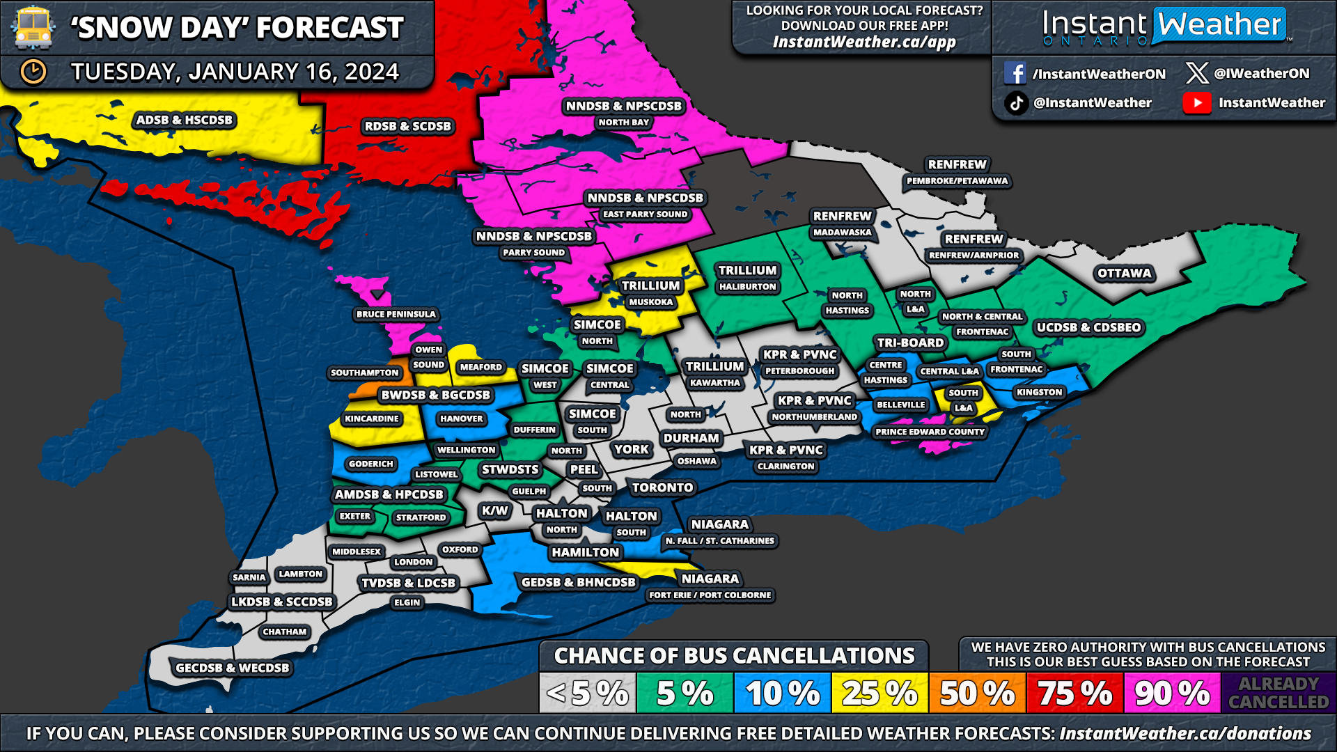
Environment Canada Issues an EXTREME COLD WARNING for Parts of Southern Ontario; -30°C Wind Chills Overnight Tuesday

NOTE: YOU CAN CLICK ON THE MAP TO OPEN A ZOOMABLE IMAGE


As the cold air continues to set in across Ontario, Environment Canada has issued an expansive Extreme Cold Warning. The alert warns of hazardous wind chill values nearing -30°C tonight into Wednesday morning. This includes Windsor, Chatham, Sarnia, London, Kitchener and Orangeville.

This intense cold poses a risk to everyone, especially young children, the elderly, individuals with chronic illnesses, outdoor workers, and those without adequate shelter.

Symptoms of cold exposure, such as shortness of breath, chest pain, muscle pain and weakness, numbness, and color change in fingers and toes, should be monitored closely.

GOOGLE AD (NOT ENDORSED BY INSTANT WEATHER)

With the risk of frostbite developing within minutes on exposed skin, it's crucial to cover up. Remember to keep emergency supplies in your vehicle, including extra blankets and jumper cables. This is especially the case as some regions are experiencing snow squalls, leading to increased potential for becoming stranded.

If conditions are too harsh for you, they are also too harsh for pets to be outdoors.

For the full list of affected locations, click here.

Stay safe and ensure you're prepared for severe cold weather conditions!


GOOGLE AD (NOT ENDORSED BY INSTANT WEATHER)

Relentless Snow Squalls to Bury Parts of Ontario’s Snowbelt in Up to a METRE (100cm) of Snow by Wednesday

NOTE: YOU CAN CLICK ON THE MAP TO OPEN A ZOOMABLE IMAGE

The coldest air of the season has settled across Southern Ontario, fueling the lake effect machine that has battered parts of the snowbelt over the weekend. Intense squalls have led to significant snowfall, with reports of over 40-50cm in the Orillia and Owen Sound region.

Though these areas saw a respite in squall activity as the bands shifted north last night, the focus now turns to a different part of the snowbelt for the next few days. A strong southwesterly flow over the Great Lakes is expected to continue through Tuesday and into Wednesday leading to continuous snow squall activity.


GOOGLE AD (NOT ENDORSED BY INSTANT WEATHER)

Heavy bands of snow is expected to settle over areas such as Tobermory, Parry Sound, Britt, and Sundridge, potentially burying them in up to 100cm, or 1 meter, of snow in the coming days. A similar situation is unfolding further north, with intense squalls east of Lake Superior, particularly impacting the Wawa area.

Lake Erie and Lake Ontario are also set to bring significant snow to the Southern Niagara Region and Prince Edward County, as squalls spill north of the border, especially by Wednesday morning. This could result in several hours of lake effect snow hammering the Fort Erie and Port Colborne region.

Off Georgian Bay, snow squalls are stretching across the Bruce Peninsula and coming ashore between Parry Sound and Britt. Minor lake-effect snow from Lake Erie and Lake Ontario is expected to continue overnight into Tuesday morning.

A weak system sliding mostly south of the border could be enhanced by the lakes, leading to heavier snow around the Niagara Region and Eastern Ontario, particularly near Kingston. For the rest of Southern Ontario, expect light snow or flurries throughout the morning, leading to a few centimetres of accumulation at most.


GOOGLE AD (NOT ENDORSED BY INSTANT WEATHER)

On Tuesday, the situation for those northeast of Georgian Bay remains unchanged, with intense squalls continuing around Parry Sound, stretching into Sundridge and North Bay. However, by late evening, the southern band may shift to a westerly direction, focusing on the Rosseau and Huntsville area and continuing into Wednesday morning, bringing extreme snowfall totals to northern Muskoka and the Parry Sound region.

For the Niagara region, the Lake Erie squall will remain south of the border for most of Tuesday but is expected to drift north by Wednesday morning. This could significantly impact the Fort Erie and Port Colborne areas with rapid snowfall accumulation and near-zero visibility. Prince Edward County may also experience intense squalls drifting as far north as Belleville and Kingston throughout Wednesday.

Later on Wednesday, intense squalls off Georgian Bay may shift southward into the Port Carling, Bracebridge, and Orillia area. There is some uncertainty regarding the squall's location overnight, but it is expected to continue into Thursday. A separate forecast for the rest of the week will be issued soon.


GOOGLE AD (NOT ENDORSED BY INSTANT WEATHER)

NOTE: YOU CAN CLICK ON THE MAP TO OPEN A ZOOMABLE IMAGE

Forecasting the exact snowfall accumulation for a specific location in a lake-effect snow event is extremely challenging. This is because of the highly localized nature of snow bands, which can lead to significant variance in totals even over short distances.

Therefore, you may notice our forecast shows significantly more snow than your weather app (including our own app). App-based forecasts often struggle with lake effect snow events due to their localized nature and reliance on data focused on larger macro-level weather events. This results in a failure to accurately capture the squalls, which operate at a micro-level, leading to intense snowfall totals.

Our forecast may still be off if the wind direction varies slightly from what the models predict, causing the snow squall band to form further north or south. That's why our forecasts use broader zones to account for this variability, meaning not everyone within these zones will see the significant totals. Essentially, we're indicating that a location within this area could see the forecasted amount.

By late Wednesday, we could be talking about extreme snowfall totals in a zone including Rosseau, Parry Sound, Sprucedale, Burk’s Falls, and Sundridge, with 40 to 80cm of snow expected over the next two days. Local totals could reach triple digits, with 100cm not out of the question if an intense band persists over a particular location.

The Bruce Peninsula and northern Muskoka, including Huntsville, Port Sydney, and North Bay, can expect around 25 to 50cm of snow, although some areas might see less, depending on squall locations. The rest of Muskoka and Algonquin Park are looking at 10-30cm of snow. Central Ontario should see less than 10cm as squalls focus northeast of Georgian Bay.


GOOGLE AD (NOT ENDORSED BY INSTANT WEATHER)

NOTE: YOU CAN CLICK ON THE MAP TO OPEN A ZOOMABLE IMAGE

In the southern Niagara region, including Fort Erie and Port Colborne, snowfall totals could range from 25 to 50cm by Wednesday's end, with most snow coming on Wednesday. Prince Edward County, including Picton, may also see over 25cm of snow in the next few days.

East of Lake Huron, heavier snow is expected in higher elevations away from the shoreline. This includes Owen Sound, Hanover, and Wingham, where between 15-30cm of snow is anticipated, mostly arriving later on Wednesday as more organized lake effect activity begins. Along the shoreline, places like Kincardine and Goderich are forecasted to see less than 10cm of snow.


GOOGLE AD (NOT ENDORSED BY INSTANT WEATHER)

NOTE: YOU CAN CLICK ON THE MAP TO OPEN A ZOOMABLE IMAGE

In Northeastern Ontario, relentless snow squall activity is likely between the Sault Ste. Marie and Wawa corridor, with snowfall totals ranging from 40-80cm. Some spots could far exceed 80cm, particularly just south of Wawa where the squalls will be most intense. Snowfall totals will quickly decrease further away from Lake Superior.


GOOGLE AD (NOT ENDORSED BY INSTANT WEATHER)

‘Snow Day’ Forecast: Localized School Bus Cancellations Possible for Tuesday in Parts of Ontario as Snow Squalls Continue

NOTE: YOU CAN CLICK ON THE MAP TO OPEN A ZOOMABLE IMAGE


GOOGLE AD (NOT ENDORSED BY INSTANT WEATHER)

Intense but localized snow squalls continue to severely affect the Bruce Peninsula, Parry Sound, and North Bay regions, leading to significant snowfall accumulation. This situation is expected to persist throughout the night and into Tuesday.

In addition, lake effect snow from Lake Ontario and Lake Erie could lead to rapid snow accumulation and difficult travel conditions in Prince Edward County and the Southern Niagara Region.

Given that the snow squalls show no signs of easing up, school bus cancellations are almost certain in the hardest-hit regions on Tuesday.


GOOGLE AD (NOT ENDORSED BY INSTANT WEATHER)

Regions that are most likely to experience a snow day on Tuesday, including Bruce Peninsula, Parry Sound, North Bay, and Prince Edward County, also had cancellations on Monday. This situation could result in an extended four-day weekend for students in these areas, with a 90% chance of school bus cancellations on Tuesday.

Manitoulin Island has a 75% chance of a snow day, while Sudbury has a lower likelihood, at 25%, as it is in a separate cancellation zone. Meanwhile, the rest of the Grey-Bruce counties, Muskoka, Napanee, and Southern Niagara have a 25-50% chance of experiencing a snow day on Tuesday.

The rest of Southern Ontario, not significantly affected by the lake effect snow, has less than a 10% chance of seeing school bus cancellations.


Disclaimer: Instant Weather has zero authority when it comes to bus and school closures. It is completely up to the school boards, bus companies, local authorities, and parents to decide what is best for their children. This is our best guess based on our forecast.


GOOGLE AD (NOT ENDORSED BY INSTANT WEATHER)

‘Snow Day’ Forecast: Snow Squalls Likely to Cancel School Buses on Monday in Parts of Central & Southwestern Ontario

NOTE: YOU CAN CLICK ON THE MAP TO OPEN A ZOOMABLE IMAGE


GOOGLE AD (NOT ENDORSED BY INSTANT WEATHER)

Snow squalls continue to batter regions in the typical snowbelt around Lake Huron and Georgian Bay, persisting through Sunday. This activity has resulted in impressive snowfall totals, reaching up to 40cm in Grey, Bruce, and Simcoe counties.

With the lake effect snow machine still going strong and showing no signs of abating over the next 24 hours, it's likely that several school bus cancellations will occur on Monday due to the poor road conditions.

During the day, the focus of the activity has been to the south, but these squalls have begun moving north toward the Bruce Peninsula, Muskoka, and Parry Sound regions. This shift implies that areas heavily impacted today might have experienced the brunt of it, as squalls are expected to remain north for most of Monday.

This change in wind direction could also bring the Lake Ontario and Erie squalls across the border, potentially impacting the Niagara, Picton, and Kingston regions on Monday morning. Consequently, bus cancellations in these regions cannot be ruled out.


GOOGLE AD (NOT ENDORSED BY INSTANT WEATHER)

While the heaviest snow has occurred around the Barrie, Midland, Orillia, and Grey-Bruce regions, additional significant snowfall overnight is not expected. Therefore, the likelihood of a snow day might seem lower than what the current conditions suggest.

We anticipate that there will be enough time for road crews to clear the roads in some of these areas. Hence, the focus of this forecast is on additional snow accumulating overnight into Monday morning.

Bruce County and regions directly east and northeast of Georgian Bay, including Muskoka, Parry Sound, North Bay, the Bruce Peninsula, and Southampton, will experience the worst conditions. There's a very high chance, about 90%, of a snow day in these regions, as rapid snow accumulation will likely render it nearly impossible for school buses to operate safely.

A snow day is also probable for Kincardine, Owen Sound, Meaford, and the northern zone of Simcoe County, with a 75% chance of school bus cancellations. This prediction is less certain since the squalls might not be active at the time, but the overnight accumulations should be sufficient to justify cancellations.

The situation is more uncertain for the rest of Simcoe County, Haliburton, Kawartha Lakes, and parts of Huron, Perth, and Dufferin counties, where a snow day is possible but only has a 50-50 chance at best.

The Prince Edward County, Belleville, and Kingston region, affected by the Lake Ontario squall, also have a 50% chance of a snow day. In the Niagara region, the likelihood is around 25%, but there's a higher chance of localized delays, especially closer to the Lake Erie shoreline where the squall activity will be most intense.

In other parts of Southern Ontario, a snow day is unlikely, as the heaviest snow will be concentrated in areas around the lakes.


Disclaimer: Instant Weather has zero authority when it comes to bus and school closures. It is completely up to the school boards, bus companies, local authorities, and parents to decide what is best for their children. This is our best guess based on our forecast.


GOOGLE AD (NOT ENDORSED BY INSTANT WEATHER)

Multi-Day Snow Squall Event Could Dump Up to 50cm of Snow on Parts of Ontario’s Snowbelt by Monday

NOTE: YOU CAN CLICK ON THE MAP TO OPEN A ZOOMABLE IMAGE

After the widespread snowstorm brought blizzard conditions and even thundersnow on Friday, attention now shifts to a potential multi-day snow squall event in parts of Ontario. This event is set to start on Saturday evening and continue through Monday.

These squalls could potentially dump over 50cm of snow locally in the typical snowbelt regions around Lake Huron, Georgian Bay, and Lake Superior in the coming days. Notable accumulations are also likely through the Fort Erie and Picton area as squalls from Lake Erie and Lake Ontario occasionally cross the border throughout Sunday.

In addition to the expected significant snowfall, these squalls pose a threat of near-zero visibility, creating dangerous driving conditions in the affected areas. It's advisable to avoid the roads until conditions improve, as the lake effect snow may lead to road closures.


GOOGLE AD (NOT ENDORSED BY INSTANT WEATHER)

Snow squall activity has started off Lake Huron and Georgian Bay as of late Saturday evening. Currently, the lake effect snow is somewhat disorganized, with a thin squall stretching across the Bruce Peninsula into the Muskoka region east of Georgian Bay. Some lake effect activity is also happening south around the Kincardine and Goderich regions.

These squalls are expected to intensify overnight, with colder temperatures leading to more efficient snow accumulation. The worst conditions are anticipated in the entire Grey and Bruce counties east of Lake Huron, extending southward into Huron and Perth counties.

Over Georgian Bay, the area between Bracebridge/Port Carling and south to Orillia/Midland will be the focus. There's a chance a strong squall will establish here, though it's uncertain if it will remain stationary or drift around. If it moves, the snowfall will spread over a larger area, as opposed to localized pockets if it remains stationary.

Early Sunday morning, the Lake Erie squall, currently affecting the Buffalo region, is expected to briefly move north of the border. This will bring heavy snow for a few hours to parts of the Niagara region. The most intense snowfall rates are expected near the Lake Erie shoreline, including Port Colborne and Fort Erie.

Similarly, late Sunday morning, the Lake Ontario band is forecasted to stretch across Prince Edward County to Kingston and possibly as far north as Brockville. While only about 5-10cm of snow is expected, it will occur rapidly, accompanied by whiteout conditions. Such events often lead to crashes on the Hwy 401 corridor between Belleville and Brockville, so extreme caution is advised if travel is necessary during this time.

Both Lake Ontario and Lake Erie squalls will move back south by early afternoon as the wind direction shifts. However, the Lake Huron and Georgian Bay squall will continue to heavily impact Muskoka, Simcoe County, Kawartha Lakes, Grey County, Bruce County, Huron County, and Perth County throughout the afternoon.


GOOGLE AD (NOT ENDORSED BY INSTANT WEATHER)

Some models suggest the Lake Huron squall could stretch far inland at times with a more northwesterly flow, potentially bringing brief heavy snow to the Greater Toronto Area, Kitchener, and Guelph. Sudden reductions in visibility are possible if one of these squalls moves into your area. Areas east of Georgian Bay, including Muskoka and Parry Sound, might get a break from the snow during the afternoon as the intense bands move southward.

By evening, the wind direction is expected to shift back to a westerly direction, leading to the return of squalls in the Muskoka and Northern Simcoe County regions, as well as the Owen Sound, Kincardine, and Wiarton areas for the Lake Huron squall. Additionally, the squalls may return to the Niagara and Picton/Kingston regions after midnight, leading to more heavy snow into early Monday morning.

Our forecast only extends to Monday afternoon due to lower confidence in the exact direction of the squalls beyond that point. However, the risk will certainly continue through Monday and into Tuesday.

Current indications suggest a more southwesterly direction throughout Monday, putting the Parry Sound, Sundridge, and North Bay regions in the path of the intense squall.

The snow squall off Lake Ontario and Erie could remain stationary for many hours through the Niagara region and Kingston area, leading to potentially significant snowfall totals. More details on this will be provided in a separate forecast.


GOOGLE AD (NOT ENDORSED BY INSTANT WEATHER)

NOTE: YOU CAN CLICK ON THE MAP TO OPEN A ZOOMABLE IMAGE

Forecasting the exact snowfall accumulation for a specific location in a lake-effect snow event is extremely challenging. This is because of the highly localized nature of snow bands, which can lead to significant variance in totals even over short distances.

Therefore, you may notice our forecast shows significantly more snow than your weather app (including our own app). App-based forecasts often struggle with lake effect snow events due to their localized nature and reliance on data focused on larger macro-level weather events. This results in a failure to accurately capture the squalls, which operate at a micro-level, leading to intense snowfall totals.

Our forecast may still be off if the wind direction varies slightly from what the models predict, causing the snow squall band to form further north or south. That's why our forecasts use broader zones to account for this variability, meaning not everyone within these zones will see the significant totals. Essentially, we're indicating that a location within this area could see the forecasted amount.

The hardest-hit regions for the Lake Huron squall are expected to be most of Grey and Bruce counties, including Port Elgin, Hanover, Chatsworth, Owen Sound, and Wiarton. Snowfall totals here by Monday afternoon will generally range from 25 to 50cm, with some localized areas possibly exceeding this mark depending on the intensity of the squall activity.

For those east of Georgian Bay, the highest snowfall totals are likely in Southern Muskoka and Northern Simcoe County. Again, snowfall totals in locations such as Midland, Washago, Gravenhurst, Bracebridge, and Port Carling will range from 25 to 50cm, with some areas potentially exceeding 50cm.

The accumulation will quickly decrease away from the main regions, as this event is very localized. Around 15 to 30cm of snow is expected for places like Parry Sound, Haliburton, Orillia, Collingwood, Shelburne, Huron County, and Perth County. Further out, locations such as Kawartha Lakes, Wasaga Beach, Fergus, and Goderich could see 10 to 25cm of snow.

Less than 15cm is possible for the surrounding areas, with most places seeing less than 5cm. However, some areas could receive more if they encounter a brief snow squall. This includes Barrie, Kitchener, Guelph, the Greater Toronto Area, and Peterborough.


GOOGLE AD (NOT ENDORSED BY INSTANT WEATHER)

NOTE: YOU CAN CLICK ON THE MAP TO OPEN A ZOOMABLE IMAGE

In the Niagara region, the highest totals will be along the Lake Erie shoreline, including Fort Erie, Port Colborne, and Turkey Point, with up to 15-30cm possible. Most of this snow will fall early Sunday morning and later in the evening.

The forecasted totals will decrease rapidly the further away from Lake Erie you are. Welland could see around 10-20cm, while Niagara Falls might get 5-10cm. St. Catharines is expected to be less affected, with maybe 5cm of snow possible.

In Eastern Ontario, Picton, Napanee, and Kingston will see the most snow from Lake Ontario. The hardest-hit areas are currently projected to receive around 10-15cm, although the southernmost tip of Prince Edward County could approach 20cm.

Along the International Border into Brockville, up to 5-10cm of snow is expected from the squall moving across the area late Sunday morning.


GOOGLE AD (NOT ENDORSED BY INSTANT WEATHER)

NOTE: YOU CAN CLICK ON THE MAP TO OPEN A ZOOMABLE IMAGE

Intense snow squalls are also ongoing south of Lake Superior and are expected to move north of the border during Sunday afternoon. This will result in rapid snow accumulation east of Lake Superior, somewhere between Wawa and Sault Ste. Marie.

Snow squall activity in this region is expected to continue into Monday and even Tuesday. By Monday afternoon, the hardest-hit areas, including Sault Ste. Marie, will see totals ranging from 25 to 50cm. Additional snowfall late Monday into Tuesday will add to these totals.

Further east, the Chapleau and Elliot Lake regions could also experience heavy lake effect snow, with around 10-20cm of accumulation possible. The rest of Northeastern Ontario should see around 5-15cm, with lower totals further away from the lake.


GOOGLE AD (NOT ENDORSED BY INSTANT WEATHER)

Blizzard Risk for Southern Ontario on Friday; When Will It Arrive?

Southern Ontario is currently on track to see a high-impact snowstorm starting Friday evening. This storm will bring a brief, but intense burst of snow leading to blizzard conditions in many areas.

Here's a region-based breakdown of the estimated timing. Please note that these are estimates, and actual start times may vary by a few hours. However, this should give you a general idea of when to expect the worst conditions.


FULL FORECAST


The blizzard is expected to begin in Deep Southwestern Ontario in the late afternoon or early evening. Areas like Windsor, Chatham, and Sarnia will likely see conditions worsen between 5-7 PM.

Once the blizzard conditions arrive, they will last for one or two hours before gradually reducing in intensity with moderate snow continuing into Saturday. Although the wind will remain a concern throughout the night so expect some blowing snow.


GOOGLE AD (NOT ENDORSED BY INSTANT WEATHER)

As the heavy snow band moves northeast, it will reach the London, Kitchener, and Goderich area shortly after dinner. The GTA, Hamilton, and Niagara regions should brace for the blizzard around 8-9 PM. Note that some of these areas might have mixed precipitation, which could reduce the severity of the blizzard.

Later in the evening, Central Ontario, including Simcoe County, Kawartha, Peterborough, and Muskoka, will experience heavy snow and strong winds. This is expected to start between 9-10 PM in the south and around 11 PM in the northern areas.


GOOGLE AD (NOT ENDORSED BY INSTANT WEATHER)

Eastern Ontario, including Kingston and the Ottawa Valley, will likely see the blizzard start around 10 PM and around midnight, respectively.

Since it's not feasible to include every location in our graphic, we recommend using the closest listed location for guidance.

Intense Blast of Snow on Friday Evening Could Bring Blizzard Conditions & Up to 20-30cm of Snow to Parts of Ontario

NOTE: YOU CAN CLICK ON THE MAP TO OPEN A ZOOMABLE IMAGE

Confidence remains high regarding a snowstorm set to impact Southern and Northeastern Ontario from late Friday into Saturday. Despite a slight reduction in the predicted snowfall totals, we're still on track for a high-impact event. This event will feature several hours of intense snowfall and strong wind gusts, which are likely to result in blizzard conditions and blowing snow.

Currently, we're anticipating a widespread snow accumulation of 15-30cm across Southern Ontario. However, areas closer to the Lake Ontario and Erie shorelines may see lower amounts, as a switch to rain is expected to limit the overall accumulation.


GOOGLE AD (NOT ENDORSED BY INSTANT WEATHER)

There's a degree of uncertainty regarding the extent of warm air intrusion, leading to discrepancies in the snowfall totals projected by different models. To account for this variance, we've opted for broader snowfall ranges instead of predicting a definitive outcome of either warm or cold air dominance.

The likelihood of warmer air influencing the weather, followed by a rapid cooldown early Saturday, introduces the risk of a flash freeze. Areas along the Lake Erie and Ontario shorelines might experience slushy conditions late Friday night due to temperatures rising to the mid-single digits and mixing with rain. This slush is expected to freeze quickly as colder air moves in behind the system, potentially leading to icy road conditions on Saturday morning.

We expect the storm's initial band of snow to hit between 4-6 PM on Friday, starting in Extreme Southwestern Ontario. This band is poised to deliver a short, intense burst of heavy snowfall, with rates of 4-8cm per hour, possibly accompanied by thundersnow.

Accompanying strong wind gusts, which could reach up to 90km/h in some localities, are expected to create hazardous driving conditions, particularly in Southwestern Ontario, the Golden Horseshoe, and parts of Central Ontario, where localized blizzard conditions may occur.

This heavy snow will progress through Southwestern Ontario, impacting London, Kitchener, and Hamilton by early evening. It will reach the Greater Toronto Area later in the evening, and eventually spread northeast to Central and Eastern Ontario, continuing overnight into early Saturday.

While the most intense snowfall will be brief, moderate snow is expected to persist behind the initial band throughout the night into Saturday. Around the Lake Ontario and Erie shorelines, a surge of warmer air Friday night into Saturday morning could result in a temporary changeover to rain, especially affecting snowfall totals in the Niagara region and parts of the Greater Toronto Area near the lakeshore.


GOOGLE AD (NOT ENDORSED BY INSTANT WEATHER)

There's increased confidence that warmer air will move in along the Lake Erie and Ontario shorelines after the intense snow band passes in the evening. This could lead to reduced snowfall totals in the Niagara region and parts of the Greater Toronto Area (GTA) near the lakeshore.

Higher-resolution models suggest that snowfall accumulation may vary significantly based on elevation. Therefore, areas like the Dundalk Highlands and along the Oak Ridges Moraine north of the GTA are likely to receive higher snowfall totals.

Steady snowfall is expected to persist throughout Southern Ontario on Saturday, with the most intense snow occurring in Eastern Ontario. The arrival of much colder air in the wake of the system will also trigger lake-effect snow squalls off Georgian Bay and Lake Huron.

These snow squall conditions are expected to continue into the next week, with the cold Arctic air remaining over our region. This could result in significant snowfall accumulations throughout the week in areas including Goderich, Kincardine, Hanover, Owen Sound, Wiarton, Barrie, Orillia, Midland, Bracebridge, Huntsville, Parry Sound, Britt, and Sundridge.

It's important to note that snowfall totals from this event will be highly variable, influenced by local factors that are difficult to precisely predict. Therefore, app-based forecasts, including ours, may vary from the forecast presented here. Our approach involves providing a broader range to account for various potential scenarios.


GOOGLE AD (NOT ENDORSED BY INSTANT WEATHER)

NOTE: YOU CAN CLICK ON THE MAP TO OPEN A ZOOMABLE IMAGE

We believe the hardest-hit regions will be parts of Eastern Ontario, specifically between Peterborough and Ottawa. The entrenched colder air in this area is expected to prevent any mixing, leading to significant snowfall.

The intense snow band on Friday could stall over Eastern Ontario for several hours, weakening gradually. Snowfall totals in this region are anticipated to range from 20 to 35cm, though localized areas could receive up to 40cm by the end of Saturday.

Central and Eastern Ontario, away from the Lake Ontario shoreline, are projected to receive about 15 to 25cm of snow. However, local accumulations could exceed 30cm, particularly in elevated regions through Orangeville, Shelburne, and York Region.

Areas around Georgian Bay, including Barrie, Orillia, and Muskoka, are expected to underperform in terms of snow accumulation. We're forecasting 10 to 20cm to account for this potential dry slot.

NOTE: YOU CAN CLICK ON THE MAP TO OPEN A ZOOMABLE IMAGE

The forecast becomes more complex further southeast into the Golden Horseshoe. Away from the shorelines of Lake Erie and Ontario, snowfall totals are likely to exceed 10cm and could approach 20cm in some areas.

Closer to the shorelines, we anticipate accumulation ranging from 5 to 15cm. This broad range accounts for the uncertainty, with areas right along the shoreline likely seeing closer to 5cm, while a few kilometres inland could receive up to 15cm.


GOOGLE AD (NOT ENDORSED BY INSTANT WEATHER)

NOTE: YOU CAN CLICK ON THE MAP TO OPEN A ZOOMABLE IMAGE

The tight gradient makes it challenging to represent on a map, hence the larger range. This 5 to 15cm range also applies to much of Deep Southwestern Ontario, including Windsor and Sarnia, with most of the snowfall occurring within a few hours late Friday afternoon.

The Lake Erie shoreline into the Hamilton region is expected to receive less than 10cm of snow. Meanwhile, the Niagara region might see the least amount, with less than 5cm possible.

NOTE: YOU CAN CLICK ON THE MAP TO OPEN A ZOOMABLE IMAGE

In Eastern Ontario, significant snowfall totals are expected to be widespread, with the 20-35cm zone southwest of Ottawa. The City of Ottawa itself is likely to see around 15 - 25cm, though totals approaching 30cm cannot be discounted.

Further southeast, the warm air will influence snowfall in the Kingston, Brockville, and Cornwall areas early Saturday morning, likely limiting totals to a general 10-20cm. However, areas right along the international border, including Cornwall and Brockville, might not even reach the 10cm mark.


GOOGLE AD (NOT ENDORSED BY INSTANT WEATHER)

NOTE: YOU CAN CLICK ON THE MAP TO OPEN A ZOOMABLE IMAGE

Northeastern Ontario is also set to be affected by this event, with over 20cm of snow forecasted starting late Friday evening. The heaviest band of snow is expected to move across Manitoulin Island and into the Sudbury region early Saturday morning, with snowfall rates of 3-6cm per hour.

Blowing snow and localized blizzard conditions are a concern during the morning hours across the southern portion of Northeastern Ontario, including Sudbury and North Bay. Moderate snowfall is expected to continue across Northeastern Ontario throughout Saturday, tapering off later in the evening.

The highest totals are forecasted from Manitoulin Island through Elliot Lake, Sudbury, and North Bay, with 20 to 35cm of snow possible. Locally, up to 40cm can't be ruled out, especially given the intensity of the morning snowfall.

Less snow is expected further northeast, with around 10-20cm for Sault Ste. Marie, Chapleau, and Timmins. Even lower amounts, ranging from 5 to 15cm, are possible from Wawa to Kapuskasing.


GOOGLE AD (NOT ENDORSED BY INSTANT WEATHER)

Get Your Shovels, Southern Ontario! The First Major Snowstorm of the Season Is on the Way This Weekend

NOTE: YOU CAN CLICK ON THE MAP TO OPEN A ZOOMABLE IMAGE

Confidence is growing in a strong system set to sweep across Southern Ontario starting Friday and persisting throughout the weekend. In contrast to previous weather systems, this one looks likely to keep most of the region on the snowy side, leading to widespread and substantial snowfall.

Although there's always a chance for last-minute changes, it's nearly certain that parts of Southern Ontario are in for a heavy snowfall this weekend. The onset is expected sometime Friday afternoon, continuing into Saturday.

We're still finalizing the exact details, but a more detailed preliminary forecast will be available later today.


GOOGLE AD (NOT ENDORSED BY INSTANT WEATHER)

Currently, we anticipate general snowfall totals in the range of 20-30cm across a broad area of Southern Ontario, extending from the Southwest through the Greater Toronto Area and into Central/Eastern Ontario.

Almost everyone in these regions should brace for significant snowfall. In some localities, particularly around Lake Huron and Georgian Bay, totals could surpass 30cm, boosted by lake-enhanced snowfall.

The combination of intense snow and potentially strong, damaging wind gusts of 70-90km/h could lead to complete whiteouts. We can't discount the possibility of blizzard conditions, especially in Southwestern Ontario.

The main area of uncertainty lies along the Lake Ontario shoreline and in the Niagara region. Some forecasts suggest a brief switch to rain overnight on Friday, followed by a return to snow on Saturday.

This could result in lower snowfall amounts near the shoreline, heavily dependent on the storm's exact path. The latest data shows a trend towards a westward path, which could introduce warmer air into the region.


GOOGLE AD (NOT ENDORSED BY INSTANT WEATHER)

Another aspect we're watching closely is the potential for significant lake effect snow following the storm, starting Sunday and possibly extending into the week. This could lead to remarkable snowfall accumulations in typical snowbelt areas such as Grey-Bruce, Simcoe County, Muskoka, and Parry Sound.

By week's end, some of these areas might be measuring the snow in FEET (1 ft = 30cm).

In summary, the upcoming week promises to be a busy one, but we're prepared and will keep you updated with in-depth information around the clock. Stay tuned!


GOOGLE AD (NOT ENDORSED BY INSTANT WEATHER)

‘Winter Storm Day’ Forecast: Second Day of School Bus Cancellations Possible in Parts of Southern Ontario on Wednesday

NOTE: YOU CAN CLICK ON THE MAP TO OPEN A ZOOMABLE IMAGE


GOOGLE AD (NOT ENDORSED BY INSTANT WEATHER)

The winter storm impacting Southern Ontario on Tuesday is set to persist into Tuesday night and early Wednesday morning. In most areas, the transition to rain has already happened or is expected shortly.

However, the forecast is different in the northern regions, including the Ottawa Valley and northern parts of Central Ontario. These areas are expected to continue seeing heavy snowfall tonight and into the early overnight hours.

Snowfall accumulations are expected to range from 15-25cm, with Sudbury and North Bay possibly receiving up to 30cm. A changeover to rain in some of these areas is anticipated just after midnight.

Given the projected snowfall amounts and their timing, it's highly probable that school buses will be cancelled across a broad region of Eastern and Central Ontario on Wednesday. This would mark the second consecutive 'snow day' for some students, as many areas already experienced cancellations on Tuesday due to the approaching storm.


GOOGLE AD (NOT ENDORSED BY INSTANT WEATHER)

In Eastern Ontario's rural school districts, including Pembroke, Renfrew, and Bancroft, there is a 90% chance of a 'snow day.' Similarly, Parry Sound, North Bay, and Sudbury also face a 90% likelihood of school cancellations.

The Ottawa school board area has a 75% chance of a 'snow day,' with a slightly lower probability reflecting uncertainty over whether the morning road conditions in urban areas will meet the threshold for bus cancellations. The Haliburton and Smiths Falls areas also have a 75% chance, as the transition to rain is expected to occur earlier, thereby limiting snowfall totals.

Chances of school bus cancellations diminish moving southwestward, where snow is expected to have already turned to rain by the evening. This leaves enough time for road crews to clear the streets. Areas like Muskoka, Northern Simcoe County, Kawartha Lakes, Peterborough, and the Belleville/Kingston region have a slight to equal chance (25-50%) of a 'snow day.'

For the rest of Southern Ontario, the likelihood of experiencing a 'snow day' on Wednesday is very low, with a maximum probability of 5-10%.


Disclaimer: Instant Weather has zero authority when it comes to bus and school closures. It is completely up to the school boards, bus companies, local authorities, and parents to decide what is best for their children. This is our best guess based on our forecast.


GOOGLE AD (NOT ENDORSED BY INSTANT WEATHER)

‘Winter Storm Day’ Forecast: Looming Winter Storm Threat Could Cancel School Buses in Parts of Southern Ontario on Tuesday

NOTE: YOU CAN CLICK ON THE MAP TO OPEN A ZOOMABLE IMAGE


GOOGLE AD (NOT ENDORSED BY INSTANT WEATHER)

A winter storm is on the horizon for Southern Ontario, anticipated to bring a diverse mix of precipitation starting Tuesday morning. This system is set to deliver significant snowfall in some regions, while others will experience a combination of snow, ice pellets, freezing rain, and rain. Consequently, Environment Canada has issued various weather alerts, including winter storm warnings, snowfall warnings, and special weather statements.

The impending storm is likely to lead to poor road conditions, raising the possibility of school bus cancellations on Tuesday. However, the timing of the storm complicates matters. The most severe conditions are expected to begin Tuesday afternoon and persist into early Wednesday. Morning conditions are not anticipated to be overly severe in most areas, but they are expected to deteriorate as the day progresses.

As a result, school boards and bus companies would need to proactively cancel bus services on Tuesday to avoid the hazardous travel conditions anticipated for the afternoon commute. Historically, the decision to proactively cancel buses has varied among school boards. The forecast heavily relies on boards with a history of proactive cancellations which are more likely to do so again, compared to those that are less inclined to cancel.


GOOGLE AD (NOT ENDORSED BY INSTANT WEATHER)

The areas of Parry Sound, North Bay, Bancroft, and Pembroke face the highest likelihood of a snow day, with bus cancellation probabilities ranging from 75 to 90%. Given the strong warning from Environment Canada and the tendency of these school boards to cancel buses based on weather warnings, a snow day in these regions seems highly probable.

For the rest of Eastern and Central Ontario, the situation is less clear and largely dependent on individual school board decisions. The Ottawa school board, being more urban, typically requires more severe conditions to cancel buses, especially given that the Environment Canada warning states the worst conditions start late on Tuesday.

Further south, the north and west areas of the Greater Toronto Area have about a 25% chance of school bus cancellations. In contrast, the more urban school boards in the Golden Horseshoe region are less likely to cancel buses as the expected impact of the storm is relatively lower.

In Deep Southwestern Ontario and the Niagara region, the probability of a snow day is approximately 5%. While snow is expected during the morning hours, it may not be sufficient to warrant cancellations.

Looking ahead to Wednesday, there's an increased likelihood of widespread snow day potential throughout Central and Eastern Ontario.


Disclaimer: Instant Weather has zero authority when it comes to bus and school closures. It is completely up to the school boards, bus companies, local authorities, and parents to decide what is best for their children. This is our best guess based on our forecast.


GOOGLE AD (NOT ENDORSED BY INSTANT WEATHER)

Winter Storm Threatens Tuesday Evening Commute Across Ontario Including the GTA; Significant Snowfall to the North With Up to 35cm Possible

NOTE: YOU CAN CLICK ON THE MAP TO OPEN A ZOOMABLE IMAGE

The New Year in Ontario has been notably active, marked by several snowy systems over the past week. This trend is expected to continue with a significant winter storm approaching, bringing heavy snow, ice pellets, and some freezing rain beginning Tuesday morning.

We are also closely monitoring a potential high-impact storm this weekend, which may deliver a more substantial impact, focusing on heavy snow rather than mixed precipitation.

More details about the looming snowstorm threat will be provided in the coming days. For now, our attention is on the imminent winter storm, which presents a complex forecast involving various winter weather threats. Weather models have struggled to determine the exact path of this system, but there is broad agreement as we approach 24 hours before the system's arrival.


GOOGLE AD (NOT ENDORSED BY INSTANT WEATHER)

The heaviest snowfall is expected to occur primarily in Northeastern Ontario, extending southward into Central and Eastern Ontario. In these areas, precipitation is likely to remain frozen for most of the event, resulting in higher snowfall totals. By early Wednesday, the hardest-hit areas could see over 20cm of snow, with some locales receiving more than 30cm.

In the rest of Southern Ontario, the scenario is more complex. We anticipate wet snow in most regions on Tuesday morning, transitioning to rain as temperatures rise, beginning in Deep Southwestern Ontario and around the Lake Huron shoreline.

The speed of the warmer air's advance northward creates uncertainty regarding overall snowfall accumulation. Strong wind gusts accompanying the icy mix may reduce visibility and cause blowing snow.

By Tuesday afternoon and evening, a large portion of Southwestern Ontario and the Golden Horseshoe is expected to shift to ice pellets and then rain. This transition may coincide with peak evening rush hour, potentially leading to hazardous travel conditions. We advise preparing for extended travel times or considering staying off the roads until conditions improve.


GOOGLE AD (NOT ENDORSED BY INSTANT WEATHER)

NOTE: YOU CAN CLICK ON THE MAP TO OPEN A ZOOMABLE IMAGE

To clarify the timeline of the various precipitation shifts, we will detail the expected impact of this winter storm for each part of Tuesday and Wednesday.

Focusing on the timeline rather than the amounts is crucial, as accumulating snow at the storm's onset will likely be washed away by rain, making accurate measurement challenging. The rapid shifts in precipitation types, leading to icy and slushy road conditions, are the main threat of this winter storm.

The storm will begin early Tuesday morning as initial bands of precipitation cross into Deep Southwestern Ontario. Heavy wet snow is expected in Windsor, Chatham, Sarnia, London, and the Niagara region, transitioning to rain by late morning.

Further north, colder air will result in more prolonged snow across the Golden Horseshoe and westward through the Kitchener region. Ice pellets may mix in, especially along the Lake Ontario shoreline and south of the Hwy 401 corridor.


GOOGLE AD (NOT ENDORSED BY INSTANT WEATHER)

NOTE: YOU CAN CLICK ON THE MAP TO OPEN A ZOOMABLE IMAGE

As the afternoon progresses, the storm will intensify across Southern Ontario. Areas in Deep Southwestern Ontario and along the Lake Erie shoreline into the Niagara region will have switched to rain, minimizing the impact.

There is uncertainty in the Lake Huron shoreline and the Greater Toronto Area, where precipitation types will vary due to slight temperature differences.

Areas closest to the shoreline, including Hamilton, Burlington, Mississauga, and Toronto, will see a mix of ice pellets and snow during the early afternoon. However, by late afternoon, some rain is expected to mix in.

Regions north of the Hwy 401 corridor are likely to experience continued heavy snow mixed with ice pellets at times. Combined with strong wind gusts of 60-80km/h, travel could be difficult due to blowing snow and ice pellets.

A slight risk of brief freezing rain exists in this area, although sustained freezing rain is unlikely. The more likely progression will be from snow to ice pellets to rain.

Heavy snow will also affect Central Ontario around Lake Simcoe and eastward along the Lake Ontario shoreline into Eastern Ontario. Expect several hours of heavy snow throughout the afternoon.

Those in the Quebec border area and the Ottawa Valley will see the first snow bands by late afternoon, starting with lighter snow and intensifying later.


GOOGLE AD (NOT ENDORSED BY INSTANT WEATHER)

NOTE: YOU CAN CLICK ON THE MAP TO OPEN A ZOOMABLE IMAGE

By evening, warmer air will begin to replace the cold air, leading to a wider transition from frozen precipitation to rain. Southwestern Ontario and the Golden Horseshoe will have mostly switched to rain.

In southern parts of Central and Eastern Ontario, snow will persist into the early evening, potentially mixing with rain near midnight.

Heavy snow will continue for the Quebec border and Ottawa Valley regions throughout the evening. Ice pellets may mix in, extending from north of Parry Sound through Huntsville to the Smiths Falls and Cornwall areas.

Northeastern Ontario is expected to see persistent heavy snow from late Tuesday afternoon through the night. Little mixing is anticipated in this area.


GOOGLE AD (NOT ENDORSED BY INSTANT WEATHER)

NOTE: YOU CAN CLICK ON THE MAP TO OPEN A ZOOMABLE IMAGE

The storm will persist into early Wednesday, primarily affecting northern parts of Central and Eastern Ontario. South of a line from Bracebridge to Smiths Falls is expected to switch to rain by midnight.

Heavy snow will continue in the Ottawa Valley and Northeastern Ontario. By mid-morning, some mixing, including ice pellets and potentially freezing rain, is expected.

By sunrise, most of Southern Ontario will have switched to rain, while snow continues in Northeastern Ontario. The Ottawa region may not experience this transition if warmer temperatures fail to displace the cold air. Wednesday morning's commute in Eastern Ontario, especially the Ottawa Valley, is likely to be challenging.

As the system leaves the region, temperatures are expected to drop below freezing by early Wednesday morning in Southwestern Ontario and late morning or early afternoon in the rest of Southern Ontario. This will result in a transition back to wet flurries later on Wednesday, although significant accumulation is unlikely.


GOOGLE AD (NOT ENDORSED BY INSTANT WEATHER)

NOTE: YOU CAN CLICK ON THE MAP TO OPEN A ZOOMABLE IMAGE

While the variety of precipitation types is a key story of this storm, overall snowfall accumulation in some areas will resemble a classic snowstorm rather than a messy winter storm.

Starting with the least affected region, Deep Southwestern Ontario and the Niagara region are expected to see less than 5cm of snowfall, primarily on Tuesday morning before being washed away by rain.

Snowfall totals along the Hwy 401 corridor from London through Hamilton to the GTA are expected to be around 5 to 10cm early on Tuesday before switching to rain. This forecast is tricky, as slight temperature variations can significantly affect snowfall amounts. Thus, focus less on specific amounts in this region.

Areas north of the Hwy 401 corridor and away from the Lake Ontario shoreline are likely to see prolonged heavy snow throughout Tuesday morning and afternoon. Snowfall totals could reach 10-15cm in some areas, especially in higher elevations around the Dundalk Highlands, Kitchener, and Guelph regions, where some models suggest localized totals may exceed 15cm.


GOOGLE AD (NOT ENDORSED BY INSTANT WEATHER)

This zone, encompassing much of southern Central and Eastern Ontario, has more variance, leading to a wider range of 5cm to 15cm in snowfall totals. This forecast acknowledges the uncertainty in this area, providing a complete picture rather than a definitive prediction.

Further north, snowfall totals of 10 to 20cm are expected from Parry Sound through Muskoka to the Tweed and Cornwall areas.

Even higher totals are anticipated in northern Central Ontario, including Sundridge, Bancroft, and the Ottawa Valley, with a general range of 15-25cm possible. Localized pockets may even see up to 30cm.

The Algonquin Park, Renfrew, and Pembroke areas are forecasted to be the worst hit in Southern Ontario, with expected snowfall between 20 to 35cm.


GOOGLE AD (NOT ENDORSED BY INSTANT WEATHER)

In addition to snowfall, significant rain and wind are associated with this system, particularly in the south. Rainfall totals will range from 30 to 50mm across Deep Southwestern Ontario, along the Lake Erie shoreline, and into parts of Eastern Ontario north of Lake Ontario.

Rainfall totals will decrease further north, with around 20 to 30mm expected along the Lake Huron shoreline and into the GTA near Lake Ontario. For southern parts of Central and Eastern Ontario, rainfall totals between 10 to 20mm are expected, but actual precipitation will be higher when melted snow is considered, raising flooding concerns.

Less than 10mm of rain is anticipated for more northern parts of Central and Eastern Ontario, as they are likely to remain predominantly on the cold side of the storm.

Strong to damaging wind gusts are also a risk during Tuesday afternoon and evening. While there is some disagreement on the intensity, some models suggest gusts could approach 90-100km/h around the Lake Erie shoreline, Niagara region, and Prince Edward County.

For the rest of Southwestern Ontario into the Golden Horseshoe, wind gusts will range from 50 to 70 km/h, with a slight chance of 70-85 km/h gusts if the more intense model proves accurate.


NOTE: YOU CAN CLICK ON THE MAP TO OPEN A ZOOMABLE IMAGE

For Northeastern Ontario, the event will primarily be a snowstorm, starting Tuesday afternoon and continuing into Wednesday afternoon.

Snowfall totals are expected to be significant, with the hardest-hit regions from Manitoulin Island through Sudbury, North Bay, and into the Kirkland Lake region anticipating 20 to 35cm, with some areas possibly reaching 40cm.

Lower amounts are forecasted further west, with 15 to 25cm expected in areas including Elliot Lake, Timmins, and Cochrane.

Closer to Lake Superior, including Sault Ste. Marie, Wawa, and Kapuskasing, around 10 to 15cm of snow is expected, although this may vary by location. For a more detailed forecast, refer to the accompanying map.

In summary, this winter storm brings a mix of precipitation types across Ontario, with varying impacts depending on the region. The forecast includes heavy snow, rain, and strong winds, with significant snowfall in certain areas. Residents should stay informed and prepare for potentially hazardous travel conditions.

Parade of Snowstorms Take Aim at Ontario Over the Next Week Beginning With Up to 15-20cm of Snow This Weekend

NOTE: YOU CAN CLICK ON THE MAP TO OPEN A ZOOMABLE IMAGE

Winter in 2023 started sluggishly, but as the New Year unfolds, Ontario is witnessing a dramatic shift in weather patterns. The mild conditions that prevailed in late December have been replaced by colder air.

This transition is not just a mere drop in temperatures; it's also bringing a series of snowy systems. Over the coming week, these systems are poised to bring considerable snowfall to various regions across the province.


GOOGLE AD (NOT ENDORSED BY INSTANT WEATHER)

The first significant snowfall is expected over the weekend, thanks to two distinct weather systems. In the north, a system originating from the US Midwest will traverse Northern Ontario starting Saturday morning.

This will result in continuous snowfall across both Northwestern and Northeastern Ontario throughout the day. By Sunday morning, snow accumulations could reach 15-20cm in some areas.

Simultaneously, a robust system from the US East Coast is anticipated to make its way northward. The northwestern fringes of this system are expected to cross into Canada by late Saturday afternoon. However, there remains some uncertainty regarding its exact path, particularly as it interacts with the northern precipitation.

This uncertainty may affect the total snowfall, but the highest accumulations are likely in Extreme Eastern Ontario, along the St. Lawrence River. Some regions here might witness up to 15cm or more of fresh snow by the weekend's end. Additionally, lake enhancement along the western shores of Lake Ontario could result in up to 10cm of snowfall in parts of the Golden Horseshoe area.

Yet, this is merely the beginning. Another potential snowstorm, tracking through our region from late Tuesday into Wednesday, is under close observation. While there's significant uncertainty about this system's development, it's highly probable that some areas in Ontario will receive over 30cm of snow.


GOOGLE AD (NOT ENDORSED BY INSTANT WEATHER)

NOTE: YOU CAN CLICK ON THE MAP TO OPEN A ZOOMABLE IMAGE

Snow has already started in Northwestern Ontario, near the international border, as of Friday evening. This snowfall is expected to intensify overnight and continue into Saturday morning. During these hours, the steady snow will gradually spread eastward, reaching Northeastern Ontario by the afternoon. Minor lake enhancement near Lake Superior might result in slightly heavier snowfall rates.

As we progress into Saturday night and early Sunday, the snowfall will start to diminish, beginning near the Manitoba border and extending to the rest of Northwestern Ontario by sunrise. In the east, snow is expected to persist through early Sunday but will gradually weaken by the afternoon.

The heaviest snowfall totals across Northern Ontario will be quite extensive. In Northwestern Ontario, the greatest accumulations are expected along the international border, extending east to Thunder Bay and along the Lake Superior shoreline. Here, snowfall is generally forecasted to range from 15 to 20cm, with potential local higher amounts, especially near Lake Superior, where the lake effect might cause uneven snow distribution.

Toward the Manitoba border, lesser snow is anticipated, with totals between 10 to 20cm expected for areas like Kenora, Dryden, and Red Lake.


GOOGLE AD (NOT ENDORSED BY INSTANT WEATHER)

NOTE: YOU CAN CLICK ON THE MAP TO OPEN A ZOOMABLE IMAGE

In contrast, Northeastern Ontario will see a more confined area with 15-20cm of snow, primarily east of Lake Superior due to lake enhancement effects. Broader regions, including Timmins, Kapuskasing, Kirkland Lake, and Sudbury, are likely to receive 10 to 15cm.

The southern areas along the Georgian Bay shoreline, such as North Bay and Manitoulin Island, will experience lower accumulations, ranging from 5 to 10cm.


GOOGLE AD (NOT ENDORSED BY INSTANT WEATHER)

As the snow exits in the north, attention shifts to a secondary system poised to brush Southern Ontario's eastern edges. This snowfall is expected to start late Saturday afternoon, beginning in the Niagara region and gradually encompassing Eastern Ontario by night.

The interaction of this storm with the northern system adds an element of unpredictability to its trajectory. A westward shift in its path could mean more widespread snowfall, potentially affecting the Golden Horseshoe and Central Ontario.

However, current projections suggest a more eastern trajectory, which would result in higher snowfall rates in the eastern part of the province, especially close to the center of the low-pressure system. Lake Ontario may also contribute to locally enhanced snowfall rates, particularly in the Western Greater Toronto Area (GTA), between Hamilton and Toronto.

This snow is expected to continue through the night and into Sunday morning, with the heaviest snow likely occurring Saturday evening and early Sunday. By noon, snowfall should start tapering off in the southwestern regions, while light snow may persist over Eastern Ontario for much of the afternoon.


GOOGLE AD (NOT ENDORSED BY INSTANT WEATHER)

NOTE: YOU CAN CLICK ON THE MAP TO OPEN A ZOOMABLE IMAGE

Forecasting the accumulation from this storm is challenging due to the low confidence in its exact path. A shift to the east could reduce snow totals, while a westward shift might bring more snow into the GTA.

Currently, it's anticipated that Extreme Eastern Ontario, stretching from Kingston through Brockville to Cornwall, could experience snowfall exceeding 15cm, possibly reaching up to 20cm. However, some models indicate a possible underperformance, with totals closer to 10 to 15cm.


GOOGLE AD (NOT ENDORSED BY INSTANT WEATHER)

The snowfall predictions decrease further west, with Ottawa and the Northern Lake Ontario shoreline expecting 10 to 15cm. A broad zone encompassing the rest of Eastern Ontario and parts of Central Ontario is forecasted to receive around 5cm, with slightly higher amounts of up to 10cm possible.

This includes the Golden Horseshoe around Lake Ontario and extends up along the Dundalk Highlands, where local areas might also see 5-10cm, depending largely on lake enhancement effects.

Less than 5cm is expected along the Georgian Bay shoreline and into Southwestern Ontario. The least snow, under 2cm, is forecasted for Deep Southwestern Ontario.

A separate update on the potential snowstorm for Tuesday will be released over the weekend. Currently, there's too much disagreement among models to confidently predict this forecast.

First Snowy Blast of the Year Could Bring Up to 5-10cm of Snow to Parts of Ontario on Wednesday

NOTE: YOU CAN CLICK ON THE MAP TO OPEN A ZOOMABLE IMAGE

Many people across Southern Ontario welcomed the New Year amid snowy conditions, as an overperforming system brought up to 5-10cm of snow locally. The heaviest snowfall occurred in the Golden Horseshoe and Kitchener areas, where heavy snow bands persisted throughout New Year’s Eve.

The snow on New Year’s Eve might just be a precursor to what lies ahead, with more snow forecasted for the first week of 2024!


GOOGLE AD (NOT ENDORSED BY INSTANT WEATHER)

A disorganized system is poised to move across Ontario from late Tuesday evening. This system, in isolation, would likely only result in a light dusting of snow. However, the combination of dropping temperatures and the ice-free Great Lakes will likely amplify snowfall in the traditional snowbelt areas thanks to some lake enhancement.

Starting around midnight, light to moderate snowfall is expected, continuing overnight into Wednesday morning. It will begin in Northern Ontario and gradually spread southward by early Wednesday. Heavier snow bands are anticipated near the eastern shores of Georgian Bay and Lake Huron, primarily impacting the Grey-Bruce area, along with Muskoka and Parry Sound.

Further from the lakes, snow will be more sporadic, as the system's main moisture concentration will be near Northeastern Ontario along the Quebec border and more dependent on enhancement from the lakes. Southern Ontario should anticipate intermittent snow throughout Wednesday, while in Northern Ontario, it's expected to ease off by Wednesday afternoon.

Lake effect snowfall will persist off Lake Huron and Georgian Bay into the afternoon and evening. Overnight, these lake effect bands will likely shift southwards with the changing wind direction, potentially bringing a few hours of heavy snow to areas south and southeast of Lake Huron and Georgian Bay in the early hours of Thursday. However, these bands should weaken by sunrise.

By late Thursday morning, the snowfall across all regions is expected to cease as the system driving the lake-effect snow departs.


GOOGLE AD (NOT ENDORSED BY INSTANT WEATHER)

NOTE: YOU CAN CLICK ON THE MAP TO OPEN A ZOOMABLE IMAGE

As previously mentioned, the heaviest snow accumulation is anticipated in the typical snowbelt areas around Lake Huron and Georgian Bay. In locales such as Goderich, Kincardine, Owen Sound, Collingwood, Parry Sound, Bracebridge, Huntsville, and Algonquin Park, snowfall totals are likely to range from 5 to 10cm.

In such lake-influenced events, it's important to note that total accumulations will vary considerably based on location, with some areas potentially receiving over 10cm.

Elsewhere in Southern Ontario, less than 5cm of snow is expected, with only trace amounts for Deep Southwestern Ontario, the Golden Horseshoe, and Eastern Ontario.


GOOGLE AD (NOT ENDORSED BY INSTANT WEATHER)

NOTE: YOU CAN CLICK ON THE MAP TO OPEN A ZOOMABLE IMAGE

In Northern Ontario, the heaviest snowfall is forecasted for Northeastern Ontario near the Quebec border, affecting Chapleau, Timmins, Kapuskasing, Cochrane, Timmins, and Kirkland Land, with expected snowfall of 5 to 10cm by midday Wednesday.

The rest of Northeastern Ontario will receive a few centimeters of fresh snow, while minimal accumulation is projected for Northwestern Ontario.


GOOGLE AD (NOT ENDORSED BY INSTANT WEATHER)

Snowy End to the Year for Southern Ontario With Accumulating Snow on New Year’s Eve

NOTE: YOU CAN CLICK ON THE MAP TO OPEN A ZOOMABLE IMAGE

The final month of 2023 has brought some unusual weather to Southern Ontario, marked by unseasonably warm temperatures and persistent fog enveloping much of the region over the past week.

This warmth led to an exceptionally mild Christmas across Southern Ontario, dashing hopes for a ‘White Christmas’ in all but the northern parts of Central and Eastern Ontario.

As the year draws to a close, there has been a noticeable shift back to colder weather, with temperatures dropping to near or below freezing over the last 24 hours. While this seems like a return to normalcy, it's worth noting that these temperatures are still slightly above average for this time of year, which is typically the beginning of the coldest period of the year.


GOOGLE AD (NOT ENDORSED BY INSTANT WEATHER)

The cooling trend is accompanied by the potential for accumulating snow, courtesy of an Alberta Clipper moving across Southern Ontario on Sunday. This system is expected to deliver 2-4cm of snow to parts of Southwestern Ontario and the Golden Horseshoe, perfectly timed for the New Year's Eve countdown.

The snowfall will start late Saturday evening, initially light and possibly beginning as freezing drizzle, particularly east of Lake Huron. The drizzle should quickly give way to scattered flurries overnight.

By Sunday morning, we anticipate heavier snow bands moving in from the west, intensifying through the afternoon with snowfall rates of 1-2cm per hour, especially along the corridor from London through Kitchener to the Golden Horseshoe.

Steady snowfall is expected to continue into the evening, creating challenges for those travelling to New Year's Eve celebrations, with reduced visibility and slushy roads.

Due to the limited moisture associated with this clipper system, the snow should be contained to areas to the south of Lake Simcoe. This means that those in Central and Eastern Ontario likely won’t even see one snowflake from this system.

The snow is expected to taper off just before midnight, although flurries may persist into the early hours of 2024, ending by sunrise on Monday.


GOOGLE AD (NOT ENDORSED BY INSTANT WEATHER)

NOTE: YOU CAN CLICK ON THE MAP TO OPEN A ZOOMABLE IMAGE

The highest snowfall totals from this event are expected to be found across parts of Southwestern Ontario and around the Golden Horseshoe. Those in locations including London, Kitchener, Hamilton, Niagara and the Greater Toronto Area (GTA) can expect total snow accumulation to generally range from 2 to 4cm.

Some localized pockets could see upwards of 4-6cm since the snowfall distribution will be quite uneven as the system moves through. While those closer to the shoreline of Lake Ontario and Erie could fall short of the 2cm mark due to slightly warmer temperatures close to the lake.

For those in Deep Southwestern Ontario and southern portions of Central Ontario, you are looking at some light flurries occurring on and off throughout the day on Sunday. For most regions, this won’t even lead to any accumulation but some could still see a light dusting with up to 2cm of accumulation.

As mentioned, those further north in Central and Eastern Ontario aren’t expected to see any snow from this system.


GOOGLE AD (NOT ENDORSED BY INSTANT WEATHER)

Looking towards the first week of 2024, it appears that the colder air is here to stick with us at least in the short term. This includes the potential for more rounds of snow throughout the week, but we aren’t expecting any significant accumulation at this point.

For those who enjoyed the mild start to winter, it looks like that is about to come to an end as we head back into more traditional winter-like weather for the start of the New Year.


GOOGLE AD (NOT ENDORSED BY INSTANT WEATHER)

Pre-Holiday Freezing Rain Risk Could Impact Travel in Ontario on Saturday

NOTE: YOU CAN CLICK ON THE MAP TO OPEN A ZOOMABLE IMAGE

As the countdown to Christmas Day continues, many are preparing to hit the roads this weekend for holiday celebrations. Despite expecting a warm Christmas on Monday, the lead-up promises some challenging weather.

Early Saturday morning, parts of Southern and Northern Ontario will encounter a mix of frozen precipitation, including wet snow and freezing rain.


GOOGLE AD (NOT ENDORSED BY INSTANT WEATHER)

Southwestern Ontario, following midnight, will experience patchy drizzle originating from Michigan. In some regions, temperatures will hover just below freezing, particularly around the Greater Toronto Area and its north, west, and east.

This will allow for some of that drizzle to freeze on contact with the ground. Areas along the lakeshore of Lake Ontario may see less freezing rain, thanks to marginally warmer lake-adjacent temperatures.

The freezing rain will persist intermittently throughout Saturday morning. However, temperatures are expected to rise later in the morning south and west of Lake Simcoe. The icy conditions will extend northeast, bringing wet flurries and freezing rain to Central and Eastern Ontario late in the morning.

The most ice accumulation is anticipated from Lake Simcoe across the Kawartha Lakes to Peterborough, extending north of Kingston. This is due to an expected 6-12 hours of continuous freezing rain from Saturday morning to late afternoon.


GOOGLE AD (NOT ENDORSED BY INSTANT WEATHER)

By Saturday evening, most areas should transition to regular rain, but northern parts of Central and Eastern Ontario might still experience freezing drizzle. The freezing rain threat could even extend overnight into early Sunday morning in the Ottawa Valley.

In Northeastern Ontario, freezing drizzle is expected throughout Saturday, subsiding by evening as temperatures rise above freezing.


GOOGLE AD (NOT ENDORSED BY INSTANT WEATHER)

NOTE: YOU CAN CLICK ON THE MAP TO OPEN A ZOOMABLE IMAGE

Although the overall impact of ice accretion from this event is predicted to be minimal, untreated surfaces might still develop a thin layer of ice.

The latest models concur that the most affected area will be north of Lake Ontario. This includes Orangeville, Newmarket, Lindsay, Peterborough, Tweed, and Smith’s Falls, with potential local ice accumulation up to a few millimetres—possibly 3-4mm in higher elevations.


GOOGLE AD (NOT ENDORSED BY INSTANT WEATHER)

An expansive area encompassing the GTA, Central, and Eastern Ontario may experience minor freezing drizzle, but significant ice accumulation is not expected. Any ice formed is likely to melt quickly once temperatures rise above freezing later on Saturday.

Snowfall from this system will be minimal, with only a few wet flurries. The greatest likelihood for any snow accumulation is in Central Ontario east of Georgian Bay, but even there, it’s anticipated to be just a few centimetres.


NOTE: YOU CAN CLICK ON THE MAP TO OPEN A ZOOMABLE IMAGE

Lastly, minor freezing drizzle is also forecasted for Northeastern Ontario, primarily east of Lake Superior. However, significant ice accumulation is not expected in this region.


GOOGLE AD (NOT ENDORSED BY INSTANT WEATHER)

High Risk of Grinchmas: Hopes of a ‘White Christmas’ This Year Dashed Across Much of Ontario

NOTE: YOU CAN CLICK ON THE MAP TO OPEN A ZOOMABLE IMAGE

What a difference a year can make! Last year at this time, Ontario was battling a historic blizzard that blanketed some areas with over 100cm of snow around Christmas. Despite the mild start to the month, those dreaming of a ‘White Christmas’ still held onto a sliver of hope that the weather pattern would shift, possibly mirroring last year's conditions and ensuring a snowy Christmas morning.


GOOGLE AD (NOT ENDORSED BY INSTANT WEATHER)

Now, with less than five days until Christmas, it's becoming more probable that much of Southern Ontario, and even parts of Northern Ontario, will see a ‘Green Christmas’ this year. The past week has been a temperature rollercoaster, with record highs and lake-effect snow events that brought significant snowfall to the snowbelt region.

However, the snow accumulation quickly melted in the following days due to a return of warmer air. As a result, Southern Ontario currently has no snow cover, making the prospect of a ‘White Christmas’ dependent on imminent snowfall.

For the rest of the week, temperatures will drop, with morning lows hitting the negative teens in Central and Eastern Ontario. While it will certainly feel like winter, the lack of precipitation over the next few days means it won't look like it.


GOOGLE AD (NOT ENDORSED BY INSTANT WEATHER)

The weekend forecast indicates a shift, with milder air bringing temperatures above freezing across Southern Ontario. This warmth will likely cause the snowpack in Central and Eastern Ontario, which accumulated earlier this week, to melt away. Light rain expected late Saturday into Sunday will further contribute to this melting.

If the current trends continue, this Christmas could be among the warmest in recent memory. Temperatures in Southwestern Ontario and the Golden Horseshoe are expected to rise into the double digits, virtually assuring a ‘Green Christmas’ in these areas.

Eastern and Central Ontario might still experience temperatures near freezing on Christmas morning, keeping alive the slim possibility of a ‘White Christmas’. However, this would require either unexpected snow on Christmas Eve or the survival of the existing snowpack, enough to surpass the 2cm ‘White Christmas’ threshold.

Further north, across Algonquin Park and near the Quebec border, temperatures are more likely to remain around the freezing mark over the weekend.


GOOGLE AD (NOT ENDORSED BY INSTANT WEATHER)

NOTE: YOU CAN CLICK ON THE MAP TO OPEN A ZOOMABLE IMAGE

A ‘White Christmas’ is usually given in Northern Ontario, but this year, even some northern areas face the risk of a ‘Grinchmas’. In southern parts of Northeastern Ontario, including Sudbury and North Bay, the chances of a ‘White Christmas’ are between 25 to 50%. With little existing snowpack and no expected snow by Christmas morning, their prospects are uncertain.

The eastern shoreline of Lake Superior, having experienced significant snowfall from earlier squall events, stands a better chance. More northern areas like Timmins and Cochrane could see fresh snow early on Christmas morning, increasing their chances of a picture-perfect ‘White Christmas’ with falling snowflakes.


GOOGLE AD (NOT ENDORSED BY INSTANT WEATHER)

NOTE: YOU CAN CLICK ON THE MAP TO OPEN A ZOOMABLE IMAGE

In Thunder Bay, whether there will be snow on the ground for Christmas is uncertain. Rain expected on Christmas Eve might melt any existing snow, though some morning snowfall is possible. It remains to be seen if this will lead to significant accumulation.


GOOGLE AD (NOT ENDORSED BY INSTANT WEATHER)

NOTE: YOU CAN CLICK ON THE MAP TO OPEN A ZOOMABLE IMAGE

For a sure ‘White Christmas’, one must venture far north in Ontario, where the snowpack is substantial and less affected by the warmer temperatures leading up to the holiday. Regions like Red Lake, Armstrong, and Fort Hope have a 90% likelihood of experiencing a ‘White Christmas’.

Of course, this forecast could change if there's a surprise snowfall event before Christmas. But as it stands, it looks like the Grinch might have his way this year!

‘Snow Day’ Forecast: Widespread Snowfall Could Lead to School Bus Cancellations in Parts of Southern Ontario on Tuesday

NOTE: YOU CAN CLICK ON THE MAP TO OPEN A ZOOMABLE IMAGE


GOOGLE AD (NOT ENDORSED BY INSTANT WEATHER)

Heavy snowfall is anticipated to blanket Southern Ontario from Monday evening into Tuesday, leading Environment Canada to issue several weather alerts, including winter travel advisories and snow squall warnings.

By Tuesday morning, snow accumulations are expected to vary widely, with 5 to 10cm forecasted in general. However, areas along the southern shores of Lake Huron and Georgian Bay might see 10 to 20cm due to lake-effect snow and squalls developing tonight.

Although the expected snowfall totals are usually not significant enough to cause school bus cancellations, strong wind gusts accompanying the snow are a concern. These winds are likely to cause blowing snow and reduced visibility, with the most severe conditions predicted for early Tuesday morning, coinciding with the time for deciding on school bus cancellations.


GOOGLE AD (NOT ENDORSED BY INSTANT WEATHER)

The area south of Georgian Bay, including Meaford and Collingwood regions, stands a 90% chance of experiencing a ‘snow day’ due to the likelihood of the highest snowfall totals. In contrast, Central Ontario and regions along the Lake Huron shoreline have a 50-75% chance of a snow day.

The variability in snowfall impacts across regions makes predicting school bus cancellations challenging. Specifically, the Barrie and Owen Sound area, under a snow squall warning for 10-20cm of snow, has a 75% chance of cancellations.

The Bancroft and Barry’s Bay region also has a strong possibility (75%) of a snow day. The latest models suggest they might receive slightly higher snowfall (up to 15cm) compared to nearby areas. The local school boards are also known to be particularly sensitive to weather conditions.

Further away from the lakes, the likelihood of a snow day diminishes, especially in urban areas like the GTA. Although widespread cancellations are unlikely, localized cancellations due to road conditions cannot be completely discounted.

There remains a chance, albeit small, that this snowfall event could exceed expectations, leading to more widespread cancellations. As a result, every region has at least a 5% chance of experiencing a snow day on Tuesday.


Disclaimer: Instant Weather has zero authority when it comes to bus and school closures. It is completely up to the school boards, bus companies, local authorities, and parents to decide what is best for their children. This is our best guess based on our forecast.


GOOGLE AD (NOT ENDORSED BY INSTANT WEATHER)

Winter Returns to Southern Ontario This Week With Heavy Rainfall Followed by Up to 15-20cm of Lake-Effect Snow by Tuesday

NOTE: YOU CAN CLICK ON THE MAP TO OPEN A ZOOMABLE IMAGE

It's hard to believe, but we're nearly a week away from Christmas Day, and most of Southern Ontario, except the snowbelt region, has yet to witness a significant snowfall this season. The little snow we've had quickly vanished, courtesy of the unusually mild start to December, with temperatures reminiscent of late fall or early spring.

However, a shift in the weather pattern is on the horizon as we approach the final week before Christmas, bringing the return of more conventional winter conditions. This change includes widespread snowfall expected between Monday and Tuesday, intensified by heavier lake effect snow bands around Lake Huron, Georgian Bay, and even Lake Ontario.

Temperatures are also poised to plummet, with much colder air sweeping across the province. We anticipate a brisk Tuesday morning, where, factoring in wind chill, it could feel like the negative teens or even lower, a stark contrast to the double-digit temperatures we've enjoyed on several days in recent weeks.


GOOGLE AD (NOT ENDORSED BY INSTANT WEATHER)

NOTE: YOU CAN CLICK ON THE MAP TO OPEN A ZOOMABLE IMAGE

Before Southern Ontario resumes its typical winter programming, a spell of milder weather is still holding on this weekend. As of Sunday afternoon, widespread rainfall is sweeping across the region.

Another bout of intense precipitation is set to hit Eastern Ontario overnight into Monday morning, courtesy of the outer precipitation bands of a potent system moving up the US East Coast. While the brunt of this storm will stay to our east, the trajectory does bring substantial rain to Extreme Eastern Ontario along the international border.


GOOGLE AD (NOT ENDORSED BY INSTANT WEATHER)

Rainfall totals across Southern Ontario for Sunday are projected to be between 10 to 15mm, with some areas receiving up to 20 to 25mm. Eastern Ontario is expected to experience heavier rainfall, with accumulations of 30 to 50mm around Kingston, Ottawa, Brockville, and Cornwall. Locally, totals exceeding 50mm can’t be ruled out, particularly east of Ottawa.

The rain should recede across Southern Ontario by late Sunday evening, although Eastern Ontario may continue to experience heavy rain into Monday morning.


GOOGLE AD (NOT ENDORSED BY INSTANT WEATHER)

NOTE: YOU CAN CLICK ON THE MAP TO OPEN A ZOOMABLE IMAGE

Following the system to our east, a gradual cooling will ensue on Monday, with temperatures nearing the freezing mark later in the day, starting in Southwestern and Central Ontario.

Late Monday, a wave of weak precipitation is expected to track across Southern Ontario, beginning with light drizzle and transitioning to flurries as temperatures fall. There's some uncertainty regarding the intensity of this snowfall, as lake enhancement off the Great Lakes will primarily drive it.

Additionally, localized snow squalls are anticipated to develop off Lake Huron, Georgian Bay, and Lake Ontario, starting Monday evening and persisting into early Tuesday.

Steady snowfall is forecasted across Southern Ontario during the overnight hours and early Tuesday morning. While the heaviest snow will be concentrated near the lakes, it seems that even inland areas in Eastern and Central Ontario will see a light dusting.

Our focus is on areas south of Georgian Bay, Lake Huron, and parts of the Niagara region, where heavier snow bands are expected off the lakes.

The snow should taper off by Tuesday morning's end, though some lake-effect flurries might linger in the snowbelt regions.


GOOGLE AD (NOT ENDORSED BY INSTANT WEATHER)

NOTE: YOU CAN CLICK ON THE MAP TO OPEN A ZOOMABLE IMAGE

Current projections indicate the potential for 10 to 20cm of snow in two specific areas: south of Collingwood over the Blue Mountains off Georgian Bay and east of Sarnia around Petrolia and Lambton Shores, due to expected heavier lake effect snow overnight into Tuesday morning. Not everyone will experience such significant snowfall, as the bands will be narrow and unpredictable.

Heavier snow is also forecasted along the southern shoreline of Lake Ontario in the Niagara region, with 10 to 15cm possible between Grimsby and Niagara-on-the-Lake, while the rest of the Niagara region might see around 5cm.

Away from the lakes, the models are divided, with some higher-resolution models predicting less snow for Central and Eastern Ontario, while others suggest much more. We're currently estimating a general 5 to 10cm of snow, though actual totals will likely vary across the region.

Hence, some areas might exceed these predictions, especially in Eastern Ontario, while others may not reach the 5cm mark. The rest of Southern Ontario, including the GTA and Deep Southwestern Ontario, should expect a few centimetres of snow over the coming days.


GOOGLE AD (NOT ENDORSED BY INSTANT WEATHER)

‘Snow Day’ Forecast: Central Ontario Likely to See School Bus Cancellations on Wednesday Due to Snow Squalls

NOTE: YOU CAN CLICK ON THE MAP TO OPEN A ZOOMABLE IMAGE


GOOGLE AD (NOT ENDORSED BY INSTANT WEATHER)

Snow squalls have developed off Georgian Bay as of Tuesday evening and are expected to persist overnight into Wednesday. Environment Canada has issued snow squall watches and warnings for the impacted areas, forecasting up to 10-25cm of snow accumulation by Wednesday.

The alerts from Environment Canada, coupled with the anticipated challenging driving conditions on Wednesday, strongly suggest that school buses will be cancelled in the Muskoka and Parry Sound regions. Consequently, we've assigned a 90% likelihood of a 'snow day' in these areas for Wednesday. For those in Simcoe County's 'north' weather zone and the Bruce Peninsula, the probability of school bus cancellations stands at 75%.


GOOGLE AD (NOT ENDORSED BY INSTANT WEATHER)

Moving south and east, the chances of school bus cancellations become less predictable, as they hinge on individual school board responses to Environment Canada's alerts. Lake effect snow is expected to move southward towards Barrie by late morning, but since bus cancellation decisions are made earlier, school boards will need to proactively cancel school buses, anticipating deteriorating conditions later in the day.

Haliburton, Kawartha Lakes, Simcoe County (West), and parts of Grey-Bruce face a 50% chance of experiencing a snow day. Meanwhile, the City of Barrie and the remainder of Grey-Bruce have a 25% likelihood of a snow day. The rest of Southern Ontario is unlikely to experience bus cancellations, as the event is expected to remain confined to the traditional snowbelt areas.


Disclaimer: Instant Weather has zero authority when it comes to bus and school closures. It is completely up to the school boards, bus companies, local authorities, and parents to decide what is best for their children. This is our best guess based on our forecast.


GOOGLE AD (NOT ENDORSED BY INSTANT WEATHER)