Fireball Lights Up the Sky (October 20 2021)

Credit ChRIS Johnson (Screen capture of video)

Did you see a fireball on October 20 2021 at approximately 12:43am? Perhaps you unknowingly captured it on a security camera.

It was seen by community members and Bonnie W. L. reported in our Ontario Storm Reports group. Kirk P. also was lucky enough to capture it on video and shared it in the group as well.

About 81 reports (to date) of this bright fireball have been submitted to American Meteor Society from observers mostly in US and Ontario. Below is the current map of the observers from the American Meteor Society event page. The path of the fireball is indicated by the blue arrow.

Map from AMS of observer locations

This video was taken by Chris Johnson in Fort Gratiot Township, US close to Sarnia, Ontario.

Here is another video from MK on YouTube.

In this case this was not a fireball of natural origins but rather a failed Russian Spy satellite. It was impressive sight nonetheless. It was very bright and fragmented upon entry.

This event was predicted and no debris was expected to reach the ground.

NASA Meteor Watch also posted about the event. See space.com’s article for more information as well.

You can report fireball observations (and also send in videos if you have them) to the American Meteor Society (AMS) or it’s partner the International Meteor Organization (IMO). The reports not only alert them to potentially scientifically significant events, they also add to the database of knowledge about meteors. In this case the observations were able to determine that the fireball was not of natural origins.

Fireball Lights Up the Sky near Ottawa (August 20 2021)

Did you see a fireball on Friday August 20 2021 at approximately 10:37pm? Perhaps you unknowingly captured it on a security camera.

Thank you to everyone that posted about it in the Ontario Storm Watch group and Anna B. who sent us her door cam video from Nepean.

About 43 reports (to date) of this bright fireball have been submitted to American Meteor Society from observers mostly in Ontario and Quebec. This video was taken by Sam Berrada.

Here is another video from wacb on YouTube.

You can report fireball observations (and also send in videos if you have them) to the American Meteor Society (AMS) or it’s partner the International Meteor Organization (IMO). The reports not only alert them to potentially scientifically significant events, they also add to the database of knowledge about meteors.

We are keeping an eye on the NASA Meteor Watch page as well as they will often provide information on significant fireballs and will update this page with more information if/when it becomes available.

Perseid Meteor Shower 2021

Photo Credit: NASA/Bill Ingalls - In this 30 second exposure, a meteor streaks across the sky during the annual Perseid meteor shower Friday, Aug. 12, 2016 in Spruce Knob, West Virginia.

Photo Credit: NASA/Bill Ingalls - In this 30 second exposure, a meteor streaks across the sky during the annual Perseid meteor shower Friday, Aug. 12, 2016 in Spruce Knob, West Virginia.

The best meteor shower of the year is upon us - the Perseids. This year we are expecting as many as 100 Perseids an hour on August 11-12. The best time to observe the shower is during the hours before sunrise on Thursday morning. Since this shower lasts from July 17 to August 24 you can see Perseid meteors before and after the peak. The Perseids are the debris from the comet Swift-Tuttle which has a 133 year orbit around our Sun.

One good way to view meteors is to just lie down and watch the sky in a dark place. August nights can sometimes be cool depending on your location so as well as a blanket or lounge chair to lie on you might want to bring a jacket, your favourite hot drink and bug spray. This year though some places are seeing unseasonable warm nights so best to check your local forecast. If you can let your eyes get adjusted to the dark before you go out to look for meteors. You can do this by avoiding bright lights including looking at your phone for 30 minutes. Even if the weather doesn’t cooperate on the night of your first choice there will be other chances to watch the Perseids.

Photo credit: NASA/JPL - An outburst of Perseid meteors lights up the sky in August 2009 in this time-lapse image.

Photo credit: NASA/JPL - An outburst of Perseid meteors lights up the sky in August 2009 in this time-lapse image.

The radiant (where the meteors appear to originate) is in the constellation called Perseus, hence the name Perseids. The constellation Perseus rises higher in the sky as the night progresses so observing later, after 2am, means you will see more meteors. This year the phase of the moon is in our favour so we should be able to see fainter meteors than in previous years.

As well as the Perseids there are also sporadic meteors at the rate of a few per hour. You may also catch a meteor from a weaker shower that is active right now as well (Alpha Capricornids, Southern Delta Aquariids, and Kappa Cygnids). If you can note which constellation the meteor appears to originate from you can distinguish between the different showers and sporadic meteors.

The Perseids are also known for producing the most fireballs of any meteor shower. A fireball is defined as a bright meteor that has survived its entry through the earth’s atmosphere and scientists are very interested in locating meteorites from it (https://www.imo.net/observations/fireballs/fireballs/). As well as human observations many fireballs have been caught on dash cams and security cameras. Some fireballs also produce a sonic boom a second or two after they pass overhead. The colour of a fireball is an important observation as it is dependent on the chemical composition of the meteor.

If you spot a fireball you can report it to the American Meteor Society https://www.amsmeteors.org/fireballs/ or the International Meteor Organization https://www.imo.net/observations/fireballs/fireball-report-program/. NASA also has a database of fireballs here https://fireballs.ndc.nasa.gov/skyfalls/.

References and further reading.

https://www.asc-csa.gc.ca/eng/astronomy/tips-tricks/perseids.asp

https://blogs.nasa.gov/Watch_the_Skies/2021/08/09/how-many-perseids-will-i-see-in-2021/

https://blogs.nasa.gov/Watch_the_Skies/2020/08/06/perseids-peak-watch-best-meteor-shower-of-the-year/
https://earthsky.org/astronomy-essentials/everything-you-need-to-know-perseid-meteor-shower

https://www.amsmeteors.org/

https://www.imo.net/

https://fireballs.ndc.nasa.gov/

https://spaceplace.nasa.gov/meteor-shower/en/ (NASA’s Space Place is a great place to explore science with your kids)

BARRIE TORNADO: Survey Results and Timeline

After Barrie was impacted on Thursday by an EF2 tornado with windspeeds reaching as high as 210km/h, we decided to post a survey that was targeted specifically to Barrie residents and we received an incredible response. Thank you so much to all those who participated and our most heartfelt thoughts remain with those who were injured and affected by not only the Barrie tornado but all five EF2 tornadoes from Thursday’s outbreak (more details on the other tornadoes further down the page).

There has been a lot of debate online and throughout the community regarding whether the Tornado Warning at 2:38 PM from Environment Canada arrived in a timely manner for those who were impacted in south Barrie. To clarify, we're not posting these results to cast shade on Environment Canada. We do, however, feel that it is important to share the facts and learn from what happened by analyzing the data.

SURVEY RESULTS:

Out of 1,470 survey responses, 106 reported damage in Barrie and 21 of those experienced significant damage.

Of the 106 with damage:

- 2 received the Tornado Warning before it hit (2%)
- 24 received the Tornado Warning while the tornado was already occurring (23%)
- 80 received the Tornado Warning after the tornado had passed (75%)

Of the 21 with significant damage:

- 0 received the Tornado Warning in advance (0%)
- 7 received the Tornado Warning while the tornado was already occurring (33%)
- 14 received the Tornado Warning after the tornado had passed (67%)

TIMELINE: 

At 12:24 AM, just after midnight, we shared our forecast map on our website, Facebook and Twitter pages that specifically mentioned Lake Simcoe and a tornado risk.

“The areas at the highest risk of these storms include much of the same areas hit hard on Tuesday stretching from Lake Huron to the northeast through Lake Simcoe and into Central Ontario. Storms are expected to develop during the early afternoon and could pose a strong wind gust, large hail and tornado risk early in their lifespan.”

Link: https://twitter.com/IWeatherON/status/1415527572105015296


At 11:16 AM, Environment Canada posted a forecast map on Twitter that highlighted Barrie in a severe thunderstorm risk and a possible tornado risk if you read the legend for the “B” zone.

Link: https://twitter.com/ECCCWeatherON/status/1415691766611783680


At 11:46 AM, Environment Canada updated their marine alert, a “Squall Watch” for Lake Simcoe to include the risk of a waterspout.

“Conditions will become favourable for severe thunderstorms this afternoon as a cold front moves in from Michigan. Squalls to 50 knots are the main threat. There will also be the risk for a waterspout.”

Link: https://twitter.com/IWeatherON/status/1415696359500521475/


At 11:59 AM, Environment Canada issued a Severe Thunderstorm Watch with the specific mention that a tornado was possible.

“Hazards: Damaging wind gusts of 90 to 110 km/h nickel-sized hail heavy downpours a tornado is also possible”.

Link: https://twitter.com/IWeatherON/status/1415702467665399816/


At 1:23 PM, we reposted our forecast map to Facebook, Twitter, and Instagram and updated it, mentioning concern about many of the areas that would eventually see a tornado that day:

”Concerned about the potential for one or two tornadoes through the Simcoe County, Kawartha Lakes, Muskoka, Haliburton region and up into Algonquin Park/Pembroke. Models consistently have a bullseye around this region and at the very least we can expect damaging wind gusts and large hail.”

Link: https://www.facebook.com/OntarioTornadoWatch/posts/4164247426999723/


At 1:43 PM, we noticed that the storms near Creemore (west of Barrie) were beginning to show developing rotation on velocity radar (wind radar) and we sent out a “Minor Rotation Detected” notification to all of those in southwest Barrie through our free mobile app Instant Weather, our Text Message Alerts subscription service, and through social media specifically mentioning these rotating storms were potentially heading towards Barrie and could produce and isolated tornado in their lifespan. However, we did mention that it may miss Barrie to the north.

”We've detected minor rotation on this storm near #Badjeros, moving east, northeast towards #Creemore. It may eventually reach #Angus, and potentially #Barrie as it continues to track east. However it may miss Barrie to the north. In rare cases, minor rotation can produce a funnel cloud or even an isolated tornado in its lifespan. Please be safe in the path of this storm and if it strengthens on radar, we will post a further update.”

Link: https://twitter.com/IWeatherON/status/1415728775631937556/


At 1:48 PM, Environment Canada issued a “Squall Warning” for Lake Simcoe that mentioned the risk for a waterspout.

“A cluster of thunderstorms from near Collingwood to Shelburne is moving eastward at 40 knots and is expected to reach Lake Simcoe just after 2:00 P.M. Wind gusts of 40 knots and frequent Cloud to ground lightning will be associated with some of these storms. There is also the risk for a waterspout.”

Link: https://twitter.com/IWeatherON/status/1415730108061605891/


At 2:20 PM, we started discussing the strengthening rotation on our livestream to Facebook, Twitter, Twitch, and YouTube.

We mentioned how it was moving into south Barrie and had the potential to produce a tornado as it was a classic super-cell with strengthening rotation:

Link to exactly 2:20 PM: https://youtu.be/yBowwR4yZ1k?t=1247


At 2:28 PM, Environment Canada issued a Severe Thunderstorm Warning for Barrie. However, it did not specifically mention the risk for a tornado.

”At 2:28 P.M. Edt, Environment Canada meteorologists are tracking a severe thunderstorm capable of producing very strong wind gusts and up to nickel size hail. This severe thunderstorm is located near Utopia, moving East at 65 km/h. Hazard: 110 km/h wind gusts and nickel size hail. Locations impacted include: Barrie, Innisfil, South Barrie, Georgina, Sutton, Utopia, Essa, Stroud, Kempenfelt Bay, Belhaven and Baldwin.”

Link: https://twitter.com/IWeatherON/status/1415740132230115330/


At 2:30 PM, likely a minute or two before touchdown, we sent out a “Rotation Detected” notification to all of southern Barrie and the surrounding communities to the south via our free mobile app Instant Weather, our Text Message Alerts subscription service, and through social media, mentioning the potential for this storm to produce and isolated tornado.

“We've detected rotation on this storm moving east of #Angus into southern #Barrie, and eventually #Stroud. Rotation on radar indicates the potential for this storm to produce a funnel cloud or even an isolated tornado in its lifespan. It may also have the risk for damaging wind gusts, hail, isolated flooding, and frequent lightning.”

Link: https://twitter.com/IWeatherON/status/1415740615267168257/


At 2:32 PM, likely just as the tornado was touching down, we posted to social media saying urging residents of Barrie to take shelter and that the storm was likely producing an isolated tornado.

“If you’re in south #Barrie you need to be taking shelter right NOW! Visible rotation and hook on radar. This storm is likely producing a tornado or has the potential at any moment.”

Link: https://www.facebook.com/OntarioTornadoWatch/posts/4164402510317548


At 2:38 PM, Environment Canada issued a Tornado Warning for Barrie.

”At 2:38 P.M. Edt, Environment Canada meteorologists are tracking a severe thunderstorm that is possibly producing a tornado. Damaging winds, large hail and locally intense rainfall are also possible.

A severe thunderstorm capable of producing a tornado is located near South Barrie, moving East at 65 km/h. Hazard: 110 km/h wind gusts and nickel size hail. A tornado is also possible.

Source: Radar indicated.

Locations impacted include: Barrie, Innisfil, South Barrie, Sibbald Point Provincial Park, Stroud, Kempenfelt Bay, Georgina Island and Sunset Beach.”

Link: https://twitter.com/IWeatherON/status/1415742667875622920/


This timeline above was only the beginning of this event as four more EF2 tornadoes touched down after Barrie was impacted. We tracked many of them on our livestream and we’re so grateful that we have such a wonderful and passionate community that most certainly helped us get the word out in advance by sharing updates to their families and friends and by sending in critical reports when it was safe to do so. We’re also very thankful that we were able to complement Environment Canada’s efforts during dangerous events like this one and we can’t say how relieved we are that there were no fatalities with five EF2 tornadoes.

Here is the preliminary list of confirmed tornadoes from July 15th, 2021:

- Barrie, ON (2:30 PM) - Wind Speed: 210km/h | Track: 12km

- Zephyr/Little Britain, ON (3:20 PM) - Wind Speed: 195km/h | Track: 30km

- Lorneville, ON (3:25 PM) - Wind Speed: 180km/h | Track: 13km

- Dwight, ON (4:15 PM) - Wind Speed: 190km/h | Track: 4.76km

- Lake Traverse, ON (5:10 PM) - Wind Speed: 190km/h | Track: 11.9km

Drone data is still being analyzed by the NTP so there could be some minor changes to the details. Additional tornadoes may also be confirmed later. We’ll be posting more updates as further information is revealed about the other four tornadoes. Thank you for your patience as we gather that information and please send any photos, videos or reports to us at help@InstantWeather.ca

And lastly, below is an interview we did with Natalie Harris about her terrifying experience as the Barrie tornado destroyed the house she was staying in.

We cannot mention enough how relieved and grateful we are that there were no fatalities or life-threatening injuries on Thursday and our thoughts remain with those who were injured and affected by the five tornadoes. More details ASAP.


ON THIS DAY: Canada's Only Confirmed F5 Tornado - Elie, Manitoba - June 22, 2007

On June 22, 2007, Canada’s only F5 rated tornado destroyed parts of Elie, Manitoba. Canada adopted the Enhanced Fujita scale in 2013 so this will be the only F5 rated tornado in our history. With wind speeds in excess of 420 km/h, it caused $39 million dollars ($48 million in 2020 dollars) of damage destroying several houses, vehicles, and the town’s flour mill.

The tornado was narrow, given its strength, reaching a width of only 300 metres. It was on the ground for roughly 40 min and travelled about 6 km. The tornado winded its way through part of the town as can be seen in the figure below from Mccarthy, Patrick & Carlsen, Dave & Slipec, Jim. (2008). Elie, Manitoba, Canada, June 22, 2007: Canada's first F5 tornado. Houses were torn completely off of their foundations and a Chrysler Fifth Avenue was reportedly tossed onto a neighbour’s roof.

elietrack.png

Fortunately, no was killed and there were no seriously injuries. According to ECCC “Many residents were out of town attending a high school graduation ceremony, and those who were home knew what to do, seeking shelter in basements and placing mattresses over their head.”

Below are two videos from Justin Hobson’s channel who witnessed this historic event. The first one was taken by Justin and the second by the residents of Elie:

Events like this remind us that we must stay alert when there is severe weather in our region and, of course, have a plan! Also, we love your reports but please only take videos or photos if it safe to do so!

References and more information:

Canada’s First F5 Tornado, ECCC

2007 Elie, Manitoba tornado, Wikipedia

10 years later, Canada’s only F5 tornado remains in a class of its own, Washington Post

BREAKING: At Least One Death Reported After Tornado Causes Significant Damage in Montréal Suburb

Je vien de voir une tornade à mascouche souffler une maison....j'espère que les gens sont ok!

Posted by Nicolas Dubreuil on Monday, June 21, 2021

Video of tornado in Mascouche, Québec (EXPLICIT LANGUAGE WARNING)

A devastating story is unfolding just outside Montréal, Québec as what appears to be a very strong tornado has torn through the community of Mascouche (around 40km north of Montréal) during the afternoon hours on Monday. Based on radar data and local reports, it appears the tornado touched down around 3:30 PM ET and stayed on the ground for several minutes as it tracked through residential areas and resulted in severe structural damage to several houses.

No severe thunderstorm or tornado warning was issued by Environment Canada before the tornado touched down in Mascouche. Only a severe thunderstorm watch was in effect at the time. A tornado warning was only issued at 4:50 PM ET for the cluster of storms outside Québec City over an hour after the initial touchdown. All tornado warnings have since ended as of 7:00 PM ET.

According to CBC News, at least one person from Mascouche has died as a result of the tornado. There are currently no other reports of fatalities or injuries related to this event although it’s still very preliminary.

Shortly after the event, reports of damage flooded social media showing debris spread throughout a neighbourhood and some structural damage including what appears to be a house under construction that was torn apart.

Posted by Marco Paquette on Monday, June 21, 2021

We’ll be updating the article with more details as we receive any further information and our thoughts and condolences are with those who were affected by today’s storms.

CONFIRMED: Manitoba's Third Tornado of the Year, an EF0 Confirmed in Altona From Wednesday's Storms (Wed, June 9, 2021)

The third tornado of the year in Manitoba has been confirmed an EF0 by the Northern Tornadoes Project and Environment Canada from the storms that rolled through on Wednesday, June 9th, 2021 in Altona.

Photo sent in from Collin S. & Rachelle B. of a trailer flipped in Altona

Photo sent in from Collin S. & Rachelle B. of a trailer flipped in Altona

The NTP originally tweeted about the investigation based on the reports from our community members:

"NTP has received reports from @IWeatherMB of some damage in Altona, MB yesterday possibly associated with a tornado. An NTP ground survey team is on its way to the damage area from UManitoba in Winnipeg. First NTP ground survey of the season! #mbstorm"

Which was followed up today where they wrote:

"Yesterday's NTP ground survey - plus video relayed by @ECCCWeatherMB - provided clear evidence of a brief EF0 tornado in Altona, MB on June 9th near 12:30 pm. Path length 1.8 km, max width 50 m, motion from SSW. Roof damage, overturned trailer, and tree damage found. #mbstorm"

Damage survey done by the NTP (Northern Tornadoes Project) @WesternuNTP on Twitter.

Damage survey done by the NTP (Northern Tornadoes Project) @WesternuNTP on Twitter.

Photo taken by Wendy E.B. and sent to us by Tracy C.

Photo taken by Wendy E.B. and sent to us by Tracy C.

A huge thank you to our community members Tracy C., Wendy E.B., Stephanie D.P., Collin S., Rachelle B., and Michelle M. for sharing their reports, which led to the investigation and ultimately, helped the NTP and Environment Canada confirm this tornado.

Photo sent in from Michelle M. of her trampoline that was lifted into power lines, causing a power outage in her area of Altona.

Photo sent in from Michelle M. of her trampoline that was lifted into power lines, causing a power outage in her area of Altona.

There was also some structure damage in the community of Grunthal as shared below by John M.

196866764_2515058095306534_3647171969422354570_n.jpeg

And Debbie W. shared this photo, also from Grunthal of a damaged shed:

199355289_1645685802291085_9176718284507904470_n.jpeg

We're so grateful that everyone stayed safe! And a huge thank you to everyone who sends in reports! They're so important when it comes to confirming tornadoes, downbursts, etc. It's very much appreciated!

"Ring of Fire" Annular Solar Eclipse (June 10 2021)

An annular solar eclipse on May 20, 2012.Credits: Dale Cruikshank

An annular solar eclipse on May 20, 2012.

Credits: Dale Cruikshank

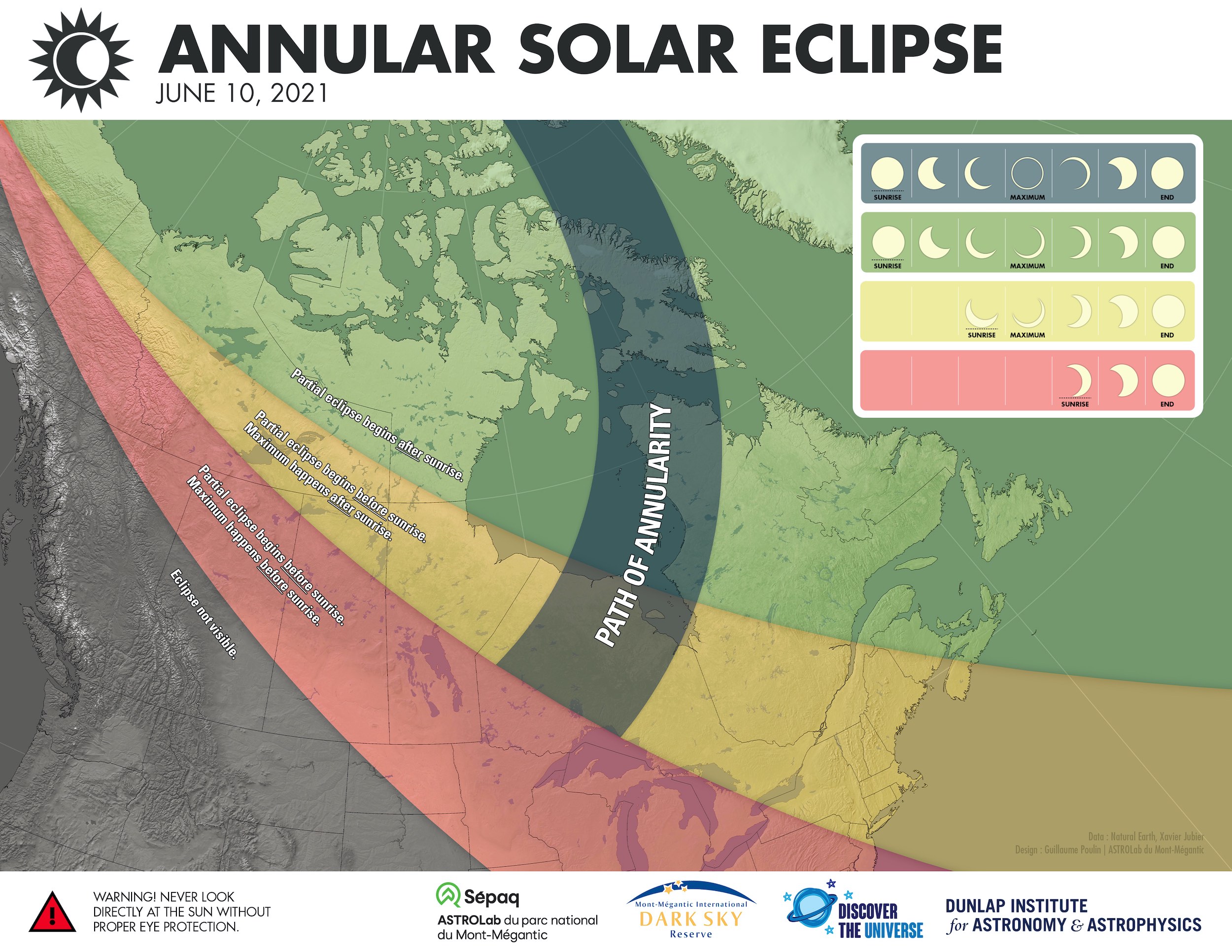
In the early morning hours on Thursday, June 10, 2021 observers in Northern Ontario, Northern Quebec, and Nunavut will have the rare chance of seeing a “Ring of Fire” or Annular Solar Eclipse, weather permitting of course.

An annular solar eclipse happens when the Moon passes in front of the Sun but is far enough away from the Earth that it does not completely cover the Sun as it would during a total eclipse.

Even if you are outside the “path of annularity” (grey in the figure below from the University of Toronto’s page on the eclipse) you may be able to see the moon partially obscuring the Sun or a partial eclipse. You will have to get up early to see it as the eclipse will have started before the Sun rises except for regions in the far north (green). The areas that are yellow on the map will see the maximum after sunrise. If you are in a location where the area is red you will only see a partial eclipse, the Moon will gradually uncover more and more of the Sun as the maximum will have occurred before sunrise.

Check out this page from timeanddate.com for more maps and information. You can also search for a specific location to see when and what you will see from timeandate.com as well. See the example below for Ottawa:

It is very important not to look directly at the Sun especially during an eclipse as you can damage your eyes. “When watching a partial solar eclipse or annular solar eclipse, you must wear solar viewing or eclipse glasses throughout the entire eclipse if you want to face the Sun. Solar viewing or eclipses glasses are NOT regular sunglasses; regular sunglasses are not safe for viewing the Sun.” from NASA's page on the eclipse.

Here are instructions on how to make a pinhole camera that you can use to safely view the eclipse in an indirect manner.

See also space.com for more information about the eclipse.

Hopefully the skies will be clear so that you can enjoy eclipse.

18 Never Before Seen Photos From Barrie's F4 Tornado (May 31st, 1985)

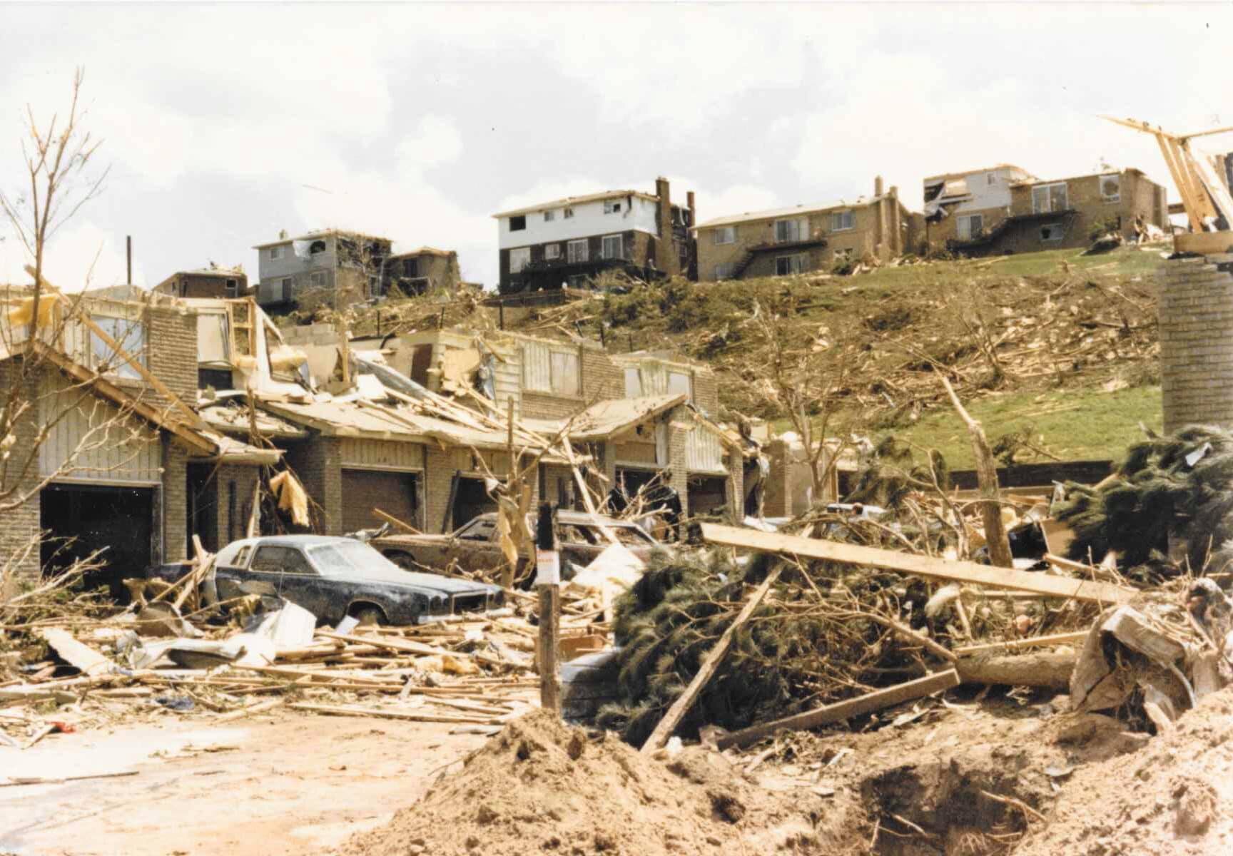
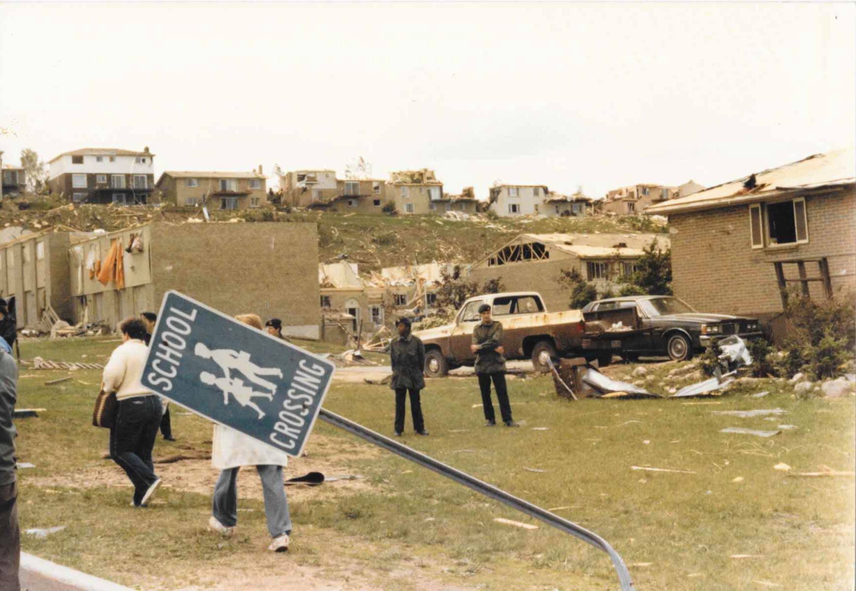
On Friday, May 31st, 1985, 14 tornadoes touched down across southern Ontario, killing 12 and injuring hundreds. Our thoughts and deepest condolences are with the families and friends of those who were lost, injured, and forever affected that day.

Our long time community member Jennifer D. came across 18 previously unseen photos from Barrie and shared her story online about what she experienced:

”May 31, 1985. We lived at the corner of Ardagh and Essa (currently where Big B Comics is). My mom and my aunt had my sister and I out doing groceries at the IGA at Essa and Tiffin. A two minute drive home, we pulled in the driveway and the sky went black. I was two and a half and I ran into the house to wake up my Dad who worked midnights and was sound asleep. My Mom grabbed Katie from the car who was only three months old and ran into the house. We went to the basement while the tornado roared over top of us-all of us except Dad. He slept through the whole thing!!! He could prob still sleep though one.

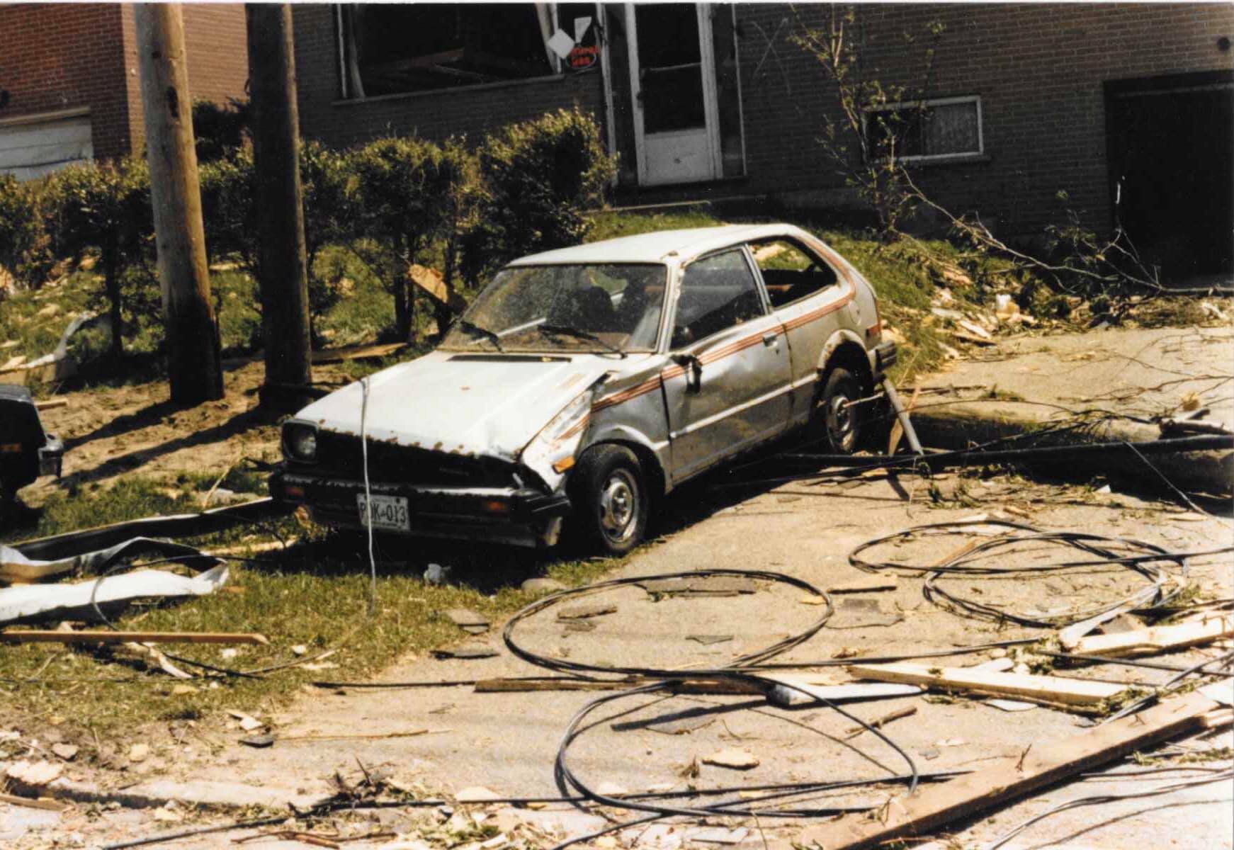
These are some pictures Mom and Dad took of the aftermath from the area. You can see Ardagh, Essa, Fairview and Innisfil as well as the racetrack. So crazy! I still have nightmares of tornadoes”

Thank you so much for sharing your experience and photos with us Jennifer and we’re so glad that you and your family stayed safe! Here are Jennifer’s photos below:

Below is an image where we combined the 14 official tornado tracks created by Dr. David Sills (Northern Tornadoes Project) with major city and town names for comparison:

Below is the actual radar image from 4:20 PM on May 31st, 1985. In this image, we compared the radar data to the official damage paths from Environment Canada. This wasn't a squall line folks, this was a 'multi-cell supercell' that ended up becoming the most prolific tornado producing storm in our province's history:

The image below is looking east in 3D at all 3 major tornado tracks at once with radar underneath. Three violent Tornadoes, two F4's and one F3 on the ground all at the same time, tracking east through our region at 105 km/h:

Here is several zoomed images of all 14 confirmed tornadoes with some major city names for comparison. Below is the Hopeness F2 Tornado, northwest of Owen Sound (3pm):

The birth of the storm that would eventually produce the Barrie F4 tornado after lifting and changing strength several times. This image includes the tracks of the F2 in Hopeville at 4:10pm, F3 in Corbetton at 4:17pm and F2 in Lisle at 4:50pm:

Below is the Grand Valley F4 (4:15pm) tornado track in red. Everyone talks about the Barrie tornado when referring to 1985 and for good reason; 8 people lost their lives and more than 100 were injured. But lets not forget the record-setting, long-track violent tornado that was the 'Grand Valley' F4 Tornado. It holds the record for the longest track tornado in Canadian history at 115km. And remember, these Tornadoes were racing forward at 105km/h so it was on the ground for more than an hour. It also tragically took the lives of 4 and injured 300.

While we’re on the topic of the Grand Valley F4, have you ever heard the tale about a house being carried by a tornado with someone inside?

Turns out, it wasn't a tale. As we learned in 2016 at the Show & Tell Simcoe County's "The Barrie Tornado Remembered" memorial, there was a family from Tottenham that told the most incredible story. Their mother, who has since passed on (may she rest in peace), was at home when the tornado hit. She remembered being carried inside of her home by the Grand Valley F4 tornado and she was eventually dropped in a field.

She remembers hitting the ground but ended being up in a coma for a month. Remarkably, when she came to, she remembered everything including being carried for quite a distance with the home intact.

We are so thankful she survived and thank you so much to the wonderful family who shared their mother's astonishing story with everyone.

For more of the story in her own words, here’s the video from the memorial: https://www.facebook.com/ShowandTellSimcoeCounty/videos/1334813139867683/

Below is the Alma F3 tornado track (4:15pm):

Below is the Wagner Lake F2 track (5:40pm):

Below is the tracks of the Reaboro F2 tornado (6:05pm) and the Lifford F2 tornado (6:20pm):

Below is the Rice Lake F2 tornado track (6:25pm):

Below is the Minto F2 tornado location (6:35pm):

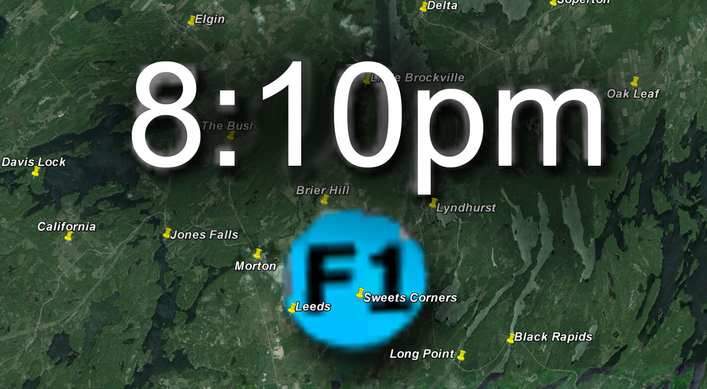
And last but not least, below is the Grippen Lake F1 tornado location (8:10pm):

In 2016, Gary Crawford was kind enough to donate the original and only known photo of the Barrie F4 tornado to us for further investigation. Thank you, Gary!

Below is Gary’s photo. He took this photo on Hwy 11, right beside the Drive In Theatre in Guthrie (on the edge of Oro Station). We scanned it at the highest possible resolution and this is originally a 65mb image but compressed to be displayed on our website:

Below is a bit of photo editing we did to simulate what Gary Crawford would have experienced when taking the only known photo of the Barrie F4 tornado producing storm. Comparing the photo and damage path, it seems possible that the dark feature on the bottom left would have been the rain-wrapped F4 tornado. Thankfully, the three Drive-in Movie Theatre screens + the tree line provided the perfect reference points to line up the photo to Google Earth street view. Great job on the incredible photo, Gary!

Below, we compared the photo even further to Google Earth to determine exactly where the photo was taken and which way it was facing. Gary confirmed our estimation of where he was located when taking the photo:

Below, the birds eye view comparison actually reveals a direct correlation between our estimated track (based on multiple, detailed reports) and the camera angle. This helps demonstrate the possibility that the left edge of Gary's photo is actually the rain-wrapped tornado:

Below is an incredible image shared to us by Shirley C. from Hwy 400 in Barrie:

Below is the official Barrie Tornado Track overview that we added to Google Earth, looking east towards Barrie’s Kempenfelt Bay:

Below are the revised (and as accurate as possible) images showing the official tornado track. We spent a lot of time making sure this was bang on as our older images were a bit too far south on review.

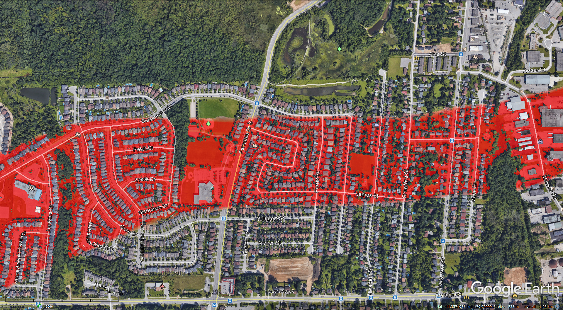
As the tornado first enters Barrie in the Ardagh area, it grew to its peak width of 500m wide:

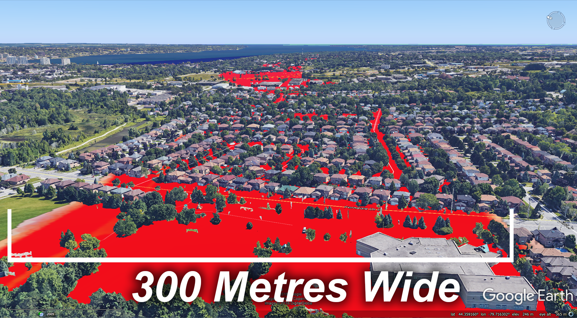
As the tornado moves past Ferndale drive, the path narrows to 300m wide:

As the tornado crosses Hwy 400 and hits the racetrack, it narrows again to 290m wide:

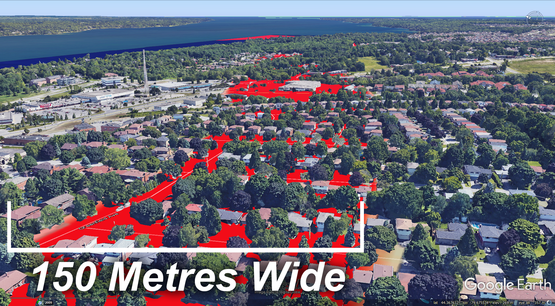
Moving towards Minet's Point, the tornado narrows one last time to 150m wide:

Finally, the tornado grows almost to its original maximum width of 480m as it demolishes the Marina and eventually moves out over Lake Simcoe. It was reported that 30 boats were ripped from their concrete moorings and thrown into Lake Simcoe, never to be recovered:

Here's hoping a day like this never returns to our region. If it does, we’re confident that with the help of our wonderful community, we will be ready.

Our deepest and heartfelt condolences and sympathies go out to the families and friends of those who were tragically killed, those were seriously injured, and those who are still to this day traumatized from this event.

- Adam & the OTW / IWO team

P.S. The link below is a photo album we've put together of damage photos from May 31st, 1985. Please let us know if we've overlooked anything. Thank you:

https://www.facebook.com/media/set/?set=a.449268851830951.1073741829.444593798965123&type=3

Damage Reports Near Wainwright Area From Tuesday, May 18, 2021

Here are some of the report and photos of the storm damage that occurred during the afternoon of Tuesday May 18 2021 near Wainwright. Thank you to everyone who shared their experience and reports with us and our thoughts are with those who were affected.

Paul L. writes: “Poles and trees down just west of Wainwright”

Carson R. “10 or so power poles snapped off 4 feet from the ground west of Wainwright”

Charleen T. “Had our 150 foot cattle shed torn in half. Poles pulled 4 feet out of the ground, wooden debris in the trees and the metal roof picked up and taken over the trees to land on the ditch on the other side. Trampoline tossed into the trees but the sandbox toys right beside we’re not disturbed…..” West of Paradise Valley


Glenda P shared these photos of downed poles 2km west of Wainright.


Charlene T. had three big evergreen trees uprooted in Wainwright. One is pictured below:

Charlene T - Wainright

Charlene T - Wainright


Lisa C. sent us these photos of her place in Wainwright.

Lisa C - Wainwright

Lisa C - Wainwright

Lisa C - Wainwright

Lisa C - Wainwright


Dominique R. sent us this picture of a horse shelter that was destroyed. They also had soffit that flew away and a shed that collapsed.

Dominique R - Wainwright

Dominique R - Wainwright


A well know business (Webb’s Machinery ) experienced substantial damage in the storm:

Edward C. - Webb’s

Edward C. - Webb’s


Bonnie WS shared these photos:


Debbie FR. reported “Hello, yes we had broken power poles , lost shingles and trees, hail . Our pool is in the trees and fence! Lots of flying trampolines and buildings. … We were out watching the storm roll in! Lots of loud rolling thunder! Wind picked up out of nowhere and blew furniture everywhere! Started raining big fat raindrops then turned to dime size hail for about 20 minutes! The wind and hail
Blew all the fresh green leaves off ! Looked like it had rained lettuce! Blue skies after about 20 minutes! Winds were very loud and clouds twirling”

Debbie F.R. Wainwright

Debbie F.R. Wainwright

Debbie F. R. - Wainwright

Debbie F. R. - Wainwright


Melaine P. reported “It just came up quickly! There was a lot of force with it. The light posts in our parking lot were wavering pretty good. Didn’t really see any damage, just small branches broken. The dirt that it was blowing made visibility not that great at times. We witnessed it from the second floor of our building, facing south. It lasted for probably 45 min to an hour, when the wind came down”


Julie D-C writes “My barn had a lot of damages: the front collapsed, a few panels flew away with shingles. We live North East of Wainwright, by Gilt Edge Hall.”

Julie D-C - Wainwright

Julie D-C - Wainwright


Darlene G - North of Wainwright

Darlene G - North of Wainwright


Chance F writes “Ripped the roof off a building right in front of us … But we were right in the middle of it and it was crazy. Truck was shaking and things were blowing everywhere. 8 power poles snapped in half about 200 yards from me”


Sandra C

Sandra C


Dian D. “Part of our roof was ripped off and what I witnessed prior to this was formation of what I thought dust devil or something to that effect in the fields neighbouring us to the south west”. Dian also share what the sky looked like just before.


Darren Jury “We lost a large tree inour driveway. Snapped off at 9’”

Darren J

Darren J


Chelsea L. sent us this video and wrote "This was south of Sedgewick around 245..."

Thank you for your help and we have submitted all of your reports to the NTP for further investigation.

Supermoon Eclipse (May 26 2021)

A telescopic visualization of the 2021 total lunar eclipse. Credits: NASA’s Scientifc Visualization Studio

A telescopic visualization of the 2021 total lunar eclipse.
Credits: NASA’s Scientifc Visualization Studio

This month’s full moon is not only a supermoon but there will also be a total lunar eclipse visible to much of North America (weather permitting) on the morning of May 26 2021 as well as other parts of the world.

A total lunar eclipse happens when the moon fully enters the earth’s shadow or umbra. The total eclipse phase will be visible near moonset in Western Canada and the United States. Observers in Eastern Canada will be able to see the start of the eclipse or penumbral phase before the moon sets. Unfortunately the martimes will not be able to see any part of the eclipse but can still enjoy the supermoon.

Below is NASA’s sheet on the lunar Eclipse. The times are in UT and you can convert UTC to your time using one of the many converters on the web. They note the times when the moon first touches the different parts of the earth’s shadow. The umbra is the darkest part of the shadow (red in the diagram below) and penumbra (grey) is when only part of sun’s light is being obscurred by the earth.

Check out this interactive map from timeanddate.com to see when and what part of the eclipse will be visible in a location near you and other locations. Some examples:

Space.com’s page also has great information about the eclipse.

The last supermoon total eclipse was nearly 6 years ago, and the next total lunar eclipse that will be visible over North America is next May. For more information about lunar eclipses in the coming decade see NASA’s page.

The full moon in May is called Flower Moon and also goes by the names of Corn Planting Moon, the Milk Moon, and the Hare Moon.

Supermoons occur when the moon is at its closest approach to the earth during the new or full phase. The orbit of the moon is elliptical and the distance from the earth to the moon varies quite a bit. It can be as close as 356,500 km at perigee (average is 363,300 km) or as far as 406,700 km at apogee (average is 405,500 km). There is a significant difference in the size and brightness of a supermoon and micromoon. A supermoon is 14% bigger and 30% brighter than a micromoon.

CREDIT: NASAJPL Edu

Educators and astronomy enthusiasts: JPL has an activity on how you could measure this difference over many months.

Strong Winds are Causing Power Outages and Damage Across the Province Today (April 30 2021)

The strong winds today are causing tree branches and trees to fall on power lines and buildings. This is making it a very busy day for fire departments, hydro companies and arborists across the province as they deal with the safety concerns, outages and needed cleanup that these damaging winds are causing. Downed power lines can also cause arcing and result in fires. There are also reports of transforms fires as well. It should also be noted that higher than normal number of elevator rescues in Toronto today are likely due to power outages.

The map below is from https://live.sinirji911.com/

From: live.sinirji911.com

From: live.sinirji911.com

https://www.torontohydro.com/outage-map

https://www.torontohydro.com/outage-map

The most up to date Toronto Hydro outage map can be found here. The following information is from Toronto Fire Active Incidents.

From toronto.ca

From toronto.ca

Hydro One is reporting 211 outages with 17,424 customers affected and those numbers are constantly changing.

Message on Hydro One website

Message on Hydro One website

Please stay safe and exercise caution especially if you come across downed power lines as they could still be live.

Tonight's Pink Supermoon (April 26 2021)

Credit: Photo of 2016 Supermoon Lauren D.

Credit: Photo of 2016 Supermoon Lauren D.

Tonight's full moon or Pink Moon is also a supermoon. The full moon in April is called Pink Moon not because it will appear pink but because of pink wildflowers (phlox) that bloom in the spring. Other names of the full moon in April are Sprouting Grass Moon, Fish Moon, Hare Moon, Egg Moon, and Paschal Moon.

Supermoons occur when the moon is at its closest approach to the earth during the new or full phase. The orbit of the moon is elliptical and the distance from the earth to the moon varies quite a bit. It can be as close as 356,500 km at perigee (average is 363,300 km) or as far as 406,700 km at apogee (average is 405,500 km). There is a significant difference in the size and brightness of a supermoon and micromoon. A supermoon is 14% bigger and 30% brighter than a micromoon.

If you miss tonight's supermoon you will get another chance next month with May's Flower Moon , which is also a supermoon and the moon will be slightly closer to earth (157km).

CREDIT: NASAJPL Edu

Educators and astronomy enthusiasts: JPL has an activity on how you could measure this difference over many months.

Be on the Alert for Possible Aurora Saturday Night (April 24/25 2021)

Credit: Tom Kroeker

Credit: Tom Kroeker

The NOAA Space Weather Prediction Center has issued a alert saying G1 and G2 geomagnetic storms are likely from the Cornal Mass Ejection (CME) that left the sun on April 22. Based on the sudden change in solar wind speed at April 24th at 2307 UT the CME has arrived (more details from spaceweather.com).

Places as far south as the northern states could potentially see aurora Saturday night.

The two main factors on whether or not you can see aurora on any given night are the level of geomagnetic activity and where you are located. Of course weather and light pollution will also affect your ability to see aurora. More tips for viewing aurora can be found at the NOAA site.

The current UTC time:

Here are some forecasts that will help:

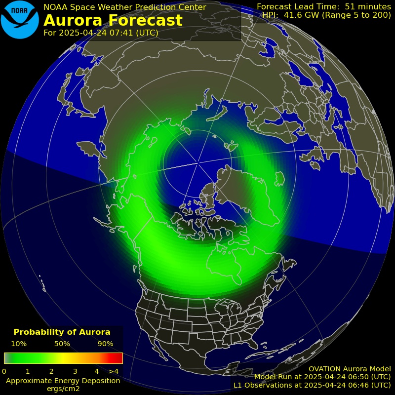
  • The OVATION Auroral Forecast from NOAA below shows probability of visible aurora at the current time. Be sure to reload if the image is not current. Day and night (dark) are indicated as well on the map to help you determine if the time is current.

Aurora Oval
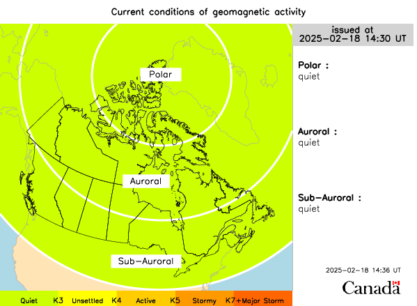
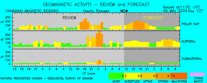
Current Conditions from Space Weather Canada

The Space Weather Gallery has some stunning photos and particularly these “Pinkest of all pinks (Aurora)” photos from Markus Varik in Norway. Pink auroras are rare and occur when particles reach lower levels of the Earth’s atmosphere. See spaceweather.com for further information.

We will update this page as new information becomes available.

Fireball Lights Up the Sky in Southern Ontario (February 26 2021)

Did you see the fireball on Friday February 26 2021 at approximately 10:07pm? Perhaps you unknownly captured it on a security camera.

Thank you to Keely K and Jamie H who alerted us to the fireball and everyone who responded to our initial post and sent us videos.

Below is a compilation of some of the videos that our community members sent in to us:

This is a compilation of videos sent in by community members of the fireball that was observed in Southern Ontario on Friday February 26 2021 at around 10:07pm.

You can report fireball observations (and also send in videos if you have them) to the American Meteor Society (AMS) or it’s partner the International Meteor Organization (IMO). The reports not only alert them to potentially scientifically significant events, they also add to the database of knowledge about meteors.

Almost 300 reports (to date) of this bright fireball have been submitted from observers in Ontario, Michigan, New York, Ohio and Pennsylvania. It was also captured on cameras from the NASA Fireball Network and the Southern Ontario Meteor Network (Western). NASA Meteor Watch says that the first analysis indicates that the meteor appeared 90 km above Erieau on the northern shore of Lake Erie and then moved northwest at a speed of 105,800 kilometers per hour, crossing the U.S./Canada border before ablating 32 kilometers above Fair Haven, Michigan.

Bright fireball over southern Ontario around 10 PM local time Observers in Ontario, Michigan, New York, Ohio and...

Posted by NASA Meteor Watch on Friday, February 26, 2021

NASA Meteor Watch also says that the orbit suggests that the meteor is from a fragment of a Jupiter family comet, though it is possible that it is also asteroidal in origin.

There are many reports that the fireball appeared green from our community members and you can see that does look green in this screenshot from Mike L‘s video.

Screen capture from video from Mike L

Screen capture from video from Mike L

The fireball was as bright as the quarter Moon and with the estimated speed NASA Meteor Watch says that the fragment had a mass of at least 2 kilograms and a diameter of approximately 12 centimeters.

Thank you to Larry M from WIndsor for sending us this unique video showing the fireball’s reflection on this vehicle. Even if your security cameras don’t point up towards the sky you may still have captured this special event.

Alberta, Saskatchewan and British Columbia were also treated to a fireball earlier this week.

Bus Cancellations & School Closures for Wednesday, February 24, 2021

Last Updated: 6:20am

**Please refresh your page every few minutes to receive the latest update**

Due to the current pandemic, some school boards have changed their policies on school bus cancellations. Some will continue the school day in a virtual format if buses are cancelled. Check with your local board for more details.


Cancellation & Closure Map (English Public and Catholic Schools)

Please note: School board boundaries are a rough estimate. Don’t use this map to determine what school board or weather zone you live in as accuracy isn’t guaranteed.

Green = No Cancellations

Red = Cancellations (Click for More Details)

Purple = School Closures (Click for More Details)

Instant Weather Bus Cancellations and School Closures for Feb 24, 2021

List of Cancellations & Closures

English Public and Catholic Schools

  • Near North Public & Nipissing-Parry Sound CathoIic - Busing is cancelled in all corridors. This includes:

    • Britt / Nobel

    • McDougall/Whitestone/Ahmic Harbour

    • Town of Parry Sound

    • Mactier, Humphrey, Rosseau

    • North Bay

    • West Nipissing (River Valley/Field, Verner/Lavigne, Sturgeon Falls/Jocko Point)

    • Mattawa

    • Callander, East Ferris and Bonfield

    • Trout Lake/Four Mile Lake Rd.

    • Redbridge /Thorne

    • Highway 11 North (Temagami, Marten River)

    • East Parry Sound (North and South)

  • Rainbow Public & Sudbury Catholic - Please note that as a precaution and to ensure student safety, school-related transportation services in the districts of Sudbury, Massey, Espanola and Manitoulin Island, are cancelled for the day, schools remain open.

  • Renfrew County Public & Renfrew County Catholic - Transportation services are CANCELLED for Madawaska area only, for Wednesday, February 24th, 2021 as there is a Winter Weather Travel Advisory. All other transportation services are RUNNING. All schools are OPEN.

  • Tri-Board - Buses are cancelled from Coe Hill north to Algonquin Park. Schools remain open.

French Schools

  • Conseil scolaire public du Grand Nord de l’Ontario (CSPGNO) - Please note that as a precaution and to ensure student safety, school-related transportation services in the districts of Sudbury, Massey, Espanola and Manitoulin Island, are cancelled for the day, schools remain open.

  • Le Conseil scolaire public du Nord-Est de l’Ontario (CSPNE) & Conseil scolaire catholique Franco-Nord - Busing is cancelled in all corridors. This includes:

    • Britt / Nobel

    • McDougall/Whitestone/Ahmic Harbour

    • Town of Parry Sound

    • Mactier, Humphrey, Rosseau

    • North Bay

    • West Nipissing (River Valley/Field, Verner/Lavigne, Sturgeon Falls/Jocko Point)

    • Mattawa

    • Callander, East Ferris and Bonfield

    • Trout Lake/Four Mile Lake Rd.

    • Redbridge /Thorne

    • Highway 11 North (Temagami, Marten River)

    • East Parry Sound (North and South)

Fireball Lights Up the Early Morning Sky in Alberta, Saskatchewan and British Columbia

This article was last updated on February 25.

Did you see the fireball this morning? Capture it on video? If you did you can send in a report to the International Meteor Organization (IMO) or American Meteor Society (AMS). Below is a video that was submitted to the AMS by Marie.

This video has been uploaded on the American Meteor Society Website. AMS Event: 978-2021, Report 222919 (978ag-2021) - Edmonton CA\nMore info here: AMS Event...

From the following NASA Meteor Watch’s post, the meteor occurred at 6:23 AM (2021 February 22) and was first visible above Skeleton Lake and moved south of west before ablating above Perryvale:

Bright fireball seen over Alberta early this morning (2021 February 22 @ 6:23 AM) There have been over 150 reports of...

Posted by NASA Meteor Watch on Monday, February 22, 2021

Weather satellites that monitor lightning also imaged this meteor because it was so bright:

The Alberta fireball was also imaged from space... It was bright enough to be detected by the Geostationary Lightning Mappers onboard the GOES 16 and 17 weather satellites.

Posted by NASA Meteor Watch on Monday, February 22, 2021

Here is the current map showing the locations of the observers from the event page on the International Meteor Organization website.

AlbertaMeteor.png

There has been enough data to estimate the size, mass and orbit of some recent bright meteors. We will update this article if more information about the meteor becomes available.

Update February 23: There are now 7 videos of the meteor can be found at the IMO event page. Including this one from Mieszko in Edmonton.

Bright streak (maybe a comet or a meteor) over Edmonton, Alberta on February 22, 2021

Update February 24: AMS has received over 100 videos and 400 reports for this meteor. They produced this fantastic video with music (hint turn on the sound) featuring some of the videos that they received.

More info here: http://www.amsmeteors.org/2021/02/bright-fireball-over-alberta-canada-on-february-22-2021/

Update February 25: University of Alberta researchers were able to calculate the orbit of the meteor. Due to the speed and the orbit they have concluded that the meteor was a fragment of a comet about the size of a grapefruit up to basketball. More details can be found here.

Southern Ontario - Snowfall Reports for February 15-16, 2021

An impactful snowstorm that caused destruction across Texas up through the Ohio Valley also brought heavy snowfall accumulation to Southern Ontario between Monday and Tuesday. Many areas saw accumulation between 15-30cm with localized reports up to 50cm.

Below is a map of over 50 snowfall accumulation reports submitted by the Instant Weather community. We have overlaid it onto our final forecast for the event so you can see how each area performed compared to our forecast. Overall, 74.51% of all reports fell within our normal or localized forecast ranges. A few notable areas underperformed the forecast throughout the GTA and into Eastern Ontario around the Kingston region.

Thanks to everyone who submitted their reports to us!

Snowfall Report Legend

Blue: 5 - 10cm

Purple: 10 - 20cm

Red: 20 - 30cm

Dark Red: 30+cm

Southern Ontario Snowfall Reports - Feb. 15-16, 2021

Bus Cancellations & School Closures for Tuesday, February 16, 2021

Last Updated: 6:30am

**Please refresh your page every few minutes to receive the latest update**

Due to the current pandemic, some school boards have changed their policies on school bus cancellations. Some will continue the school day in a virtual format if buses are cancelled. Check with your local board for more details.


Cancellation & Closure Map (English Public and Catholic Schools)

Please note: School board boundaries are a rough estimate. Don’t use this map to determine what school board or weather zone you live in as accuracy isn’t guaranteed.

Green = No Cancellations

Red = Cancellations (Click for More Details)

Purple = School Closures (Click for More Details)

List of Cancellations & Closures

English Public and Catholic Schools

  • Avon MaitIand Public & Huron-Perth CathoIic - There are many cancellations, please visit this link for more details: https://geoquery.hpsts.ca/Alerts

  • BIuewater Public & Bruce-Grey Catholic - There are many cancellations, please visit this link for more details: https://www.mybrucegreyschoolbus.ca/Cancellations.aspx

  • Durham Public & Durham Catholic - DSTS has cancelled Zone 1, 2 & 3 transportation for today due to inclement weather.

  • Grand Erie Public & Brant HaIdimand Norfolk Catholic - All Grand Erie schools and board facility sites in ALL zones are CLOSED today (February 16) due to inclement weather.

  • Greater Essex Public & Windsor Essex CathoIic - Area A - City of Windsor - All Board Provided Transportation is Cancelled for the day. Area B - County of Essex - All Board Provided Transportation is Cancelled for the day.

  • HaIton Public & Halton Catholic - All Halton District (HDSB) and Halton Catholic District (HCDSB) schools and workplaces are closed and all transportation services are cancelled in Zones 1, 2 and 3.

  • HamiIton Wentworth Public & HamiIton Wentworth Catholic - All HWDSB schools, admin buildings and child care centres are closed today, Feb. 16, due to severe weather conditions. All remote and in-person learning, including the Elementary Remote Learning Program, are cancelled. Buses are not running. All schools and administration buildings of the Hamilton-Wentworth Catholic District School Board (HWCDSB) are closed today, Tuesday, February 16, 2021, due to inclement weather. Opportunities for asynchronous learning are available to students online. All staff, instructional and non-instructional, will transition to a remote learning/work day.

  • Kawartha Pine Ridge Public & Peterborough Victoria NorthumberIand Clarington Catholic - Please be advised that, due to inclement weather and snow conditions, busing and school transportation is cancelled today for all of the STSCO jurisdiction, including Peterborough, Northumberland and Clarington areas. All KPR Schools are closed.

  • Lambton Kent Public & St. CIair Catholic - BUSES IN ALL ZONES CANCELLED TODAY. ALL SCHOOLS ARE OPEN.

  • Near North Public & Nipissing-Parry Sound CathoIic - Busing is cancelled in all corridors.

  • Niagara Public & Niagara Catholic - Due to inclement weather, schools are closed, and transportation is cancelled, for the District School Board of Niagara and the Niagara Catholic District School Board.

  • Ottawa CarIeton Public & Ottawa Catholic - Due to inclement weather all school buses & school vans are cancelled for today Tuesday, February 16, 2021. Schools are open, however, parents/guardians are responsible for transportation of students attending open schools at the end of the day.

  • PeeI Public & Dufferin-PeeI Catholic - All buses are cancelled & school buildings are closed to students due to inclement weather conditions.

  • Renfrew County Public & Renfrew County Catholic - All transportation services are CANCELLED, for Tuesday February 16, 2021 due to Snow Fall Warning. All schools are OPEN.

  • Simcoe County Public & Simcoe Catholic - All vehicles in Simcoe County are cancelled today. Simcoe-Muskoka Catholic schools are closed and will offer remote learning.

  • Thames Valley Public & London CathoIic - All school purpose vehicles serving TVDSB & LDCSB are CANCELLED for the entire day due to inclement weather.

  • Toronto Public & Toronto Catholic - Due to the significant snowfall overnight and the anticipated delays on the road, all buses are cancelled, however all TDSB schools remain open for those returning to in-person learning today.

  • Tri-Board - Due to current and forecasted inclement weather all school bus and taxi transportation is cancelled in the Tri-Board Student Transportation Services jurisdiction. The schools will remain open however any students driven to school by parents or guardians will need to be picked up at the end of the day.

  • Trillium LakeIands - Due to current weather and road conditions, all buses to schools in the City of Kawartha Lakes, Haliburton County, and the District of Muskoka for Trillium Lakelands District School Board have been cancelled for Tuesday, February 16. Schools are closed and remote learning will be offered to students within the region.

  • Upper Canada Public & Eastern Ontario CathoIic - Transportation is cancelled today due to road and weather conditions. CDSBEO schools remain open. UCDSB schools will be closed and will provide a remote learning day.

  • Upper Grand Public, Dufferin-PeeI Catholic & Wellington CathoIic - All school taxis and buses will not be operating today. All schools, Public, Catholic, French Public and French Catholic are closed

  • WaterIoo Public & WaterIoo Catholic - All Buses Cancelled, All Schools Closed Due to the current weather conditions ALL SCHOOL BUSES, TAXIS AND SPECIAL EDUCATION ROUTES operated by the Waterloo Catholic District School Board and Waterloo Region District School Board are cancelled. All WCDSB and WRDSB schools and sites are CLOSED and it will be a Remote Learning Day.

  • York Public & York Catholic - Due to inclement weather conditions all schools are closed to students today, February 16, 2021. School transportation will not be operating. Parents: do not send your child to school today. Learning will continue online for today.

French Schools

  • Conseil des écoles publiques de l’Est de l’Ontario (CEPEO) - School transportation is cancelled in all regions. Schools remain open.

  • Conseil scolaire de district catholique Centre-Sud - There are cancellations and/or school closures. Visit this link for a complete list: https://www.cscmonavenir.ca/ecole/

  • Conseil scolaire de district catholique de l'Est Ontarien - School transportation cancelled today (all regions). Schools remain open.

  • Conseil des écoles catholiques de langue française du Centre-Est - School transport is cancelled in all regions today due to poor weather conditions. However, the schools remain open.

  • Conseil scolaire catholique Providence - Area A - City of Windsor - All Board Provided Transportation is Cancelled for the day. Area B - County of Essex - All Board Provided Transportation is Cancelled for the day. Region of Lambton, Chatham-Kent, Oxford, Middlesex (London included): Transportation is cancelled today. Region of Bruce-Grey (rural routes): Transportation is cancelled today. Only routes in the city of Owen Sound are running.

  • Conseil scolaire Viamonde - Region of Durham, Toronto, Bruce-Grey (rural routes), York, Kitchener-Waterloo, Simcoe, Peel, Oxford, Niagara, Middlesex (London included), Lambton, Hamilton, Halton, Chatham-Kent: Transportation is cancelled today. Only routes in the city of Owen Sound are running.

  • Le Conseil scolaire public du Nord-Est de l’Ontario (CSPNE) & Conseil scolaire catholique Franco-Nord - Busing is cancelled in all corridors.

Preparing for an Ice Storm: What You Need to Know

At Instant Weather, we have been closely monitoring a system that is expected to bring significant freezing rain to a large portion of Southern Ontario Christmas Eve. At this point in time, a large swath of the province is expected to receive a few hours of freezing rain, resulting in up to 15 mm of ice. Our latest forecast can be found here which outlines the risk of an ice storm. Ice storms, similar to hurricanes, are rated using a scale system called the Sperry-Piltz Ice Accumulation (SPIA) Index. This Index considers the amount of ice accretion and the strength of the winds when categorizing these storms. Based on the possible amounts of ice accretion and forecasted winds, it appears that we are looking at a Level 1 ice storm. This level of storm can result in some local power outages. The main concern is an increase in wind speed and heavy snow that is expected to follow the period of freezing rain which may result in an increase in power outages as branches and power lines receive additional weight.
SPIA Index, Copyright Author: Sidney K. Sperry

It is important to be prepared for these situations so we have put together a list of items you should have on hand in case of an emergency:

  • Flashlight (windup or battery operated)

  • Radio (windup or battery operated)

  • Extra batteries

  • Portable cell phone charger

  • Water (2 litres per person per day)

  • Non-perishable canned or dried food

  • Manual can opener

  • Blankets

  • Candles and matches or lighters

  • First aid kit and any prescriptions/medical items

  • List of emergency numbers

  • Cash

  • Gasoline

Not sure what kind of food to have ready? Dried food like rice and pasta along with canned tuna can go a long way. Other items such as bread and granola bars are good for fibre and non-refrigerated fruits like bananas, oranges and apples help break up the high-sodium content found in dried foods. For water, an easy way to store a large amount is to fill a bathtub and use the water for drinking, cooking, and flushing toilets.

Since ice storms occur during the winter and early spring months, keeping warm is a major concern during extended power outages from ice storms. Electric baseboard heaters and space heaters will not work. However, natural gas furnaces will still work, but electrical components such as the blower, which forces the warm air through the vents, will not. There are some propane heaters that can be used indoors, but be careful because outdoor propane heaters produce carbon monoxide, making them very dangerous to use inside a home.

Another item worth adding to your emergency kit arsenal is a generator. Generators are available in a variety of sizes and capacities based on individual needs. There are a few things to consider when picking a generator: type, power and additional features.

There are home standby generators that are permanently in place and start up automatically when the power goes out. These units are large and can be quite expensive. There are also smaller, portable generators that either run strictly on gas or on either gas or propane (dual fuel). There is an added benefit of running your generator on propane as it less expensive to run.

Every generator has two power ratings: starting watts and running watts. In order to determine the power of generator you need, you first need to determine what appliances will be running. In the event of an emergency, you may find that the only necessities are the fridge and furnace fan.

Source: Canadian Tire - Running and starting wattages of common appliances

It is EXTREMELY important to not run a generator in your house due to the risk of carbon monoxide poisoning.

With proper planning and preparation, everyone should be able to get through the stress that comes with extended periods without power. In the case of an ice storm, it’s important to stay indoors and reduce unnecessary travel. Also, we recommend not clogging up emergency lines with non-emergencies. Your power will be back before you know it!

References

www.campsafe.org/2014/02/07/hello-world-2/

www.canadiantire.ca/en/howto/project.html/project/outdoor/how-to-choose-a-generator.html

www.houstonpress.com/restaurants/10-tasty-foods-for-riding-out-a-hurricane-7688913

www.hydroone.com/power-outages-and-safety/emergency-preparedness

www.spia-index.com/index.php