Widespread Evacuations as Northwestern Ontario Wildfires Strain Underfunded Provincial Resources
/
SOURCE: NOAA
An escalating wildfire emergency is unfolding across Northwestern Ontario, where extreme heat, critically low humidity and strong winds have caused dozens of fires to explode in size, devastated at least one First Nation and forced widespread evacuations.
As of Wednesday, July 15, there were 180 active wildfires across Ontario, with 136 burning in the Northwest Region alone. Dozens remained out of control, while firefighting resources were being prioritized for fires posing the greatest immediate threat to communities, critical infrastructure and public safety.
Crews have been pulled back from some fires because the extreme behaviour has made direct suppression too dangerous. At the same time, the scale of the emergency is renewing questions about whether years of underbudgeting for forest firefighting left the province with less flexibility to position crews, aircraft and equipment before conditions deteriorated.
Ontario budgeted $150 million for Emergency Forest Firefighting this year, despite spending an estimated $271 million last year. A larger initial budget would not necessarily have prevented the current fires or stopped their explosive growth under such extreme weather conditions. However, firefighters have warned that unreliable upfront funding can delay the acquisition and deployment of critical resources when several fires ignite or intensify simultaneously.
Mandatory evacuations are now underway across several First Nations, communities and rural townships in Northwestern Ontario. Other areas, including Ignace, Pickle Lake, Atikokan and Upsala, remain on evacuation standby as conditions continue to evolve.
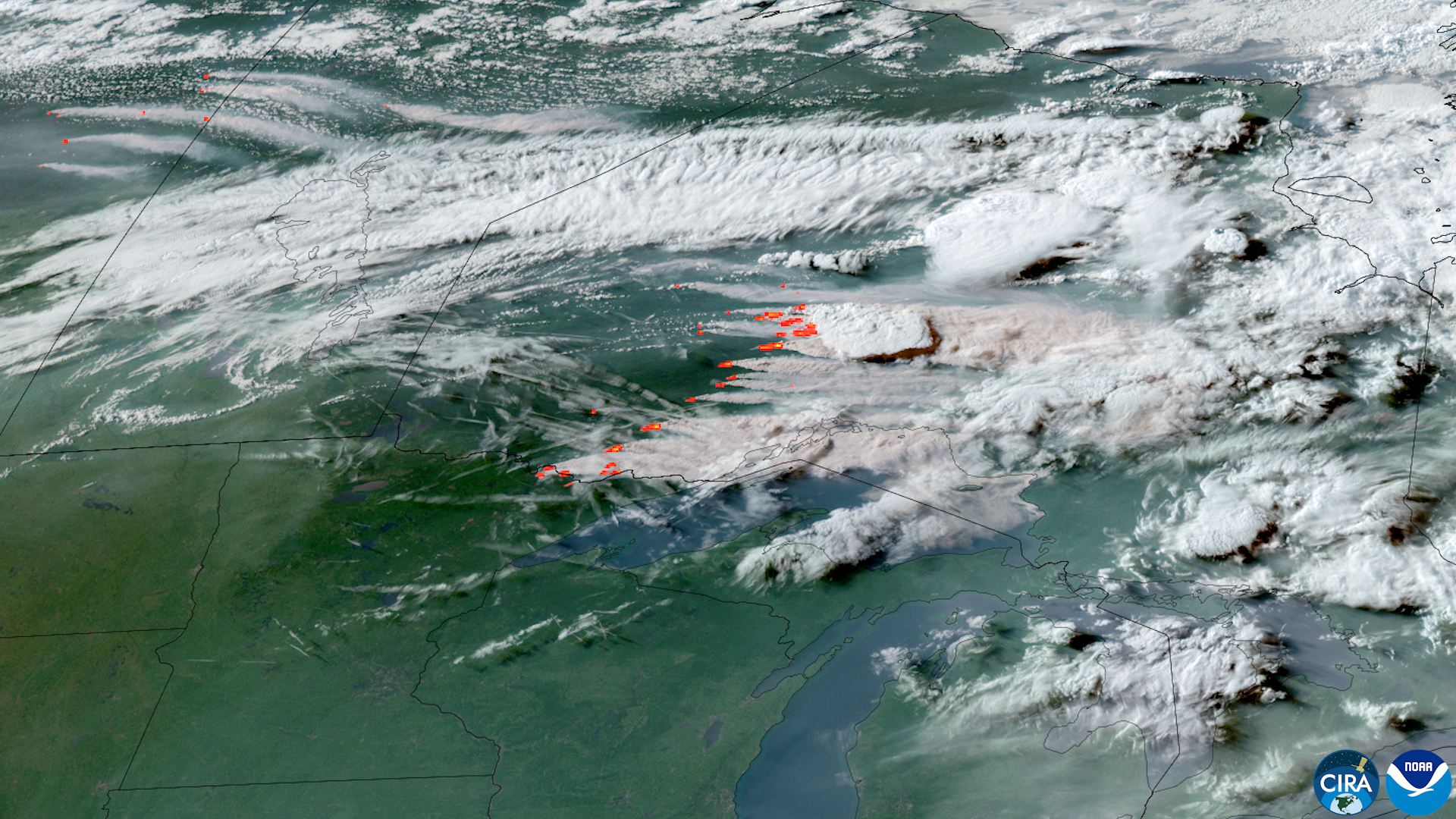
Beyond the immediate fire zone, enormous smoke plumes have nearly blocked out daylight around Thunder Bay and caused some of the worst air quality Southern Ontario has experienced in years. Smoke has spread into Quebec and the northeastern United States, exposing millions of people to unhealthy and, in some locations, potentially hazardous air.
Nearly 150 Active Fires in Northwestern Ontario
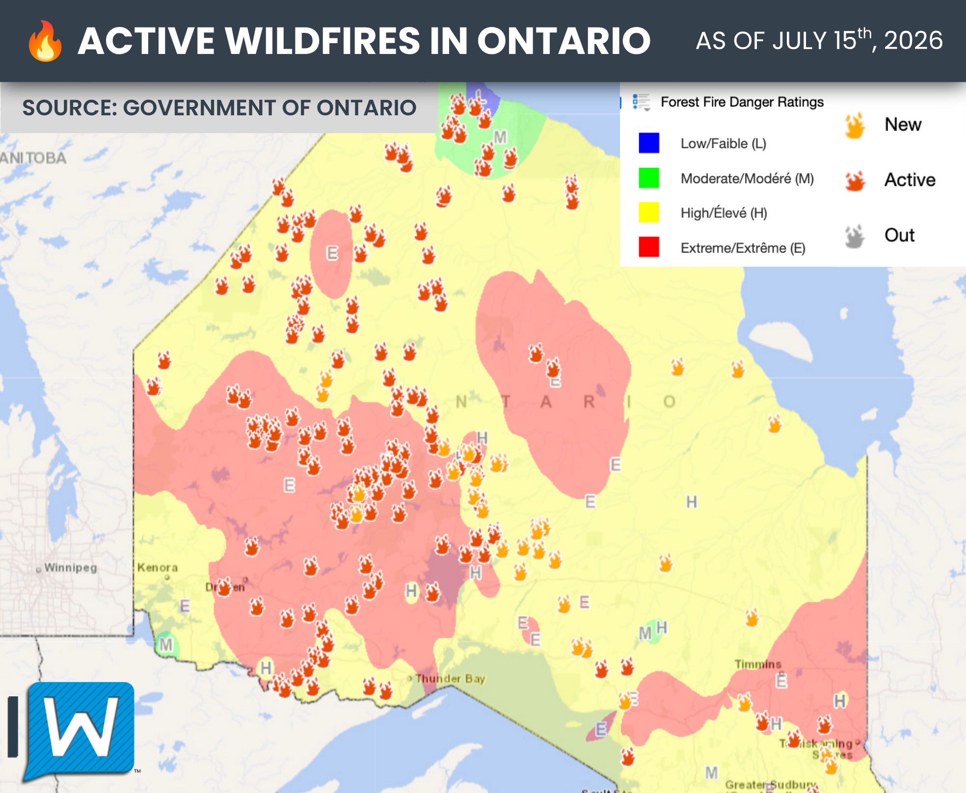
Of the 180 active wildfires reported across Ontario as of Wednesday evening, 136 are burning in the Northwest Region, including 26 new fires that were discovered on Tuesday and 8 more on Wednesday.
As it stands, 63 fires in the Northwest are classified as not under control, five are being held, five are under control, and 63 were being observed. Four fires were declared out during the day.
The number of simultaneous fires has forced officials to prioritize available resources. Fires threatening populated areas, critical infrastructure and evacuation routes are receiving the greatest attention, along with fires where crews have a reasonable chance of safely and successfully slowing their spread.
Some remote fires may be monitored rather than actively suppressed, while personnel and aircraft are directed toward more immediate threats. A fire being observed does not necessarily mean it has been abandoned, as monitoring can be a standard management strategy for remote fires that are not threatening people or infrastructure.
However, with dozens of out-of-control fires and several communities threatened at once, the current situation is placing immense pressure on Ontario’s wildfire response capacity.
How the Wildfire Situation Escalated
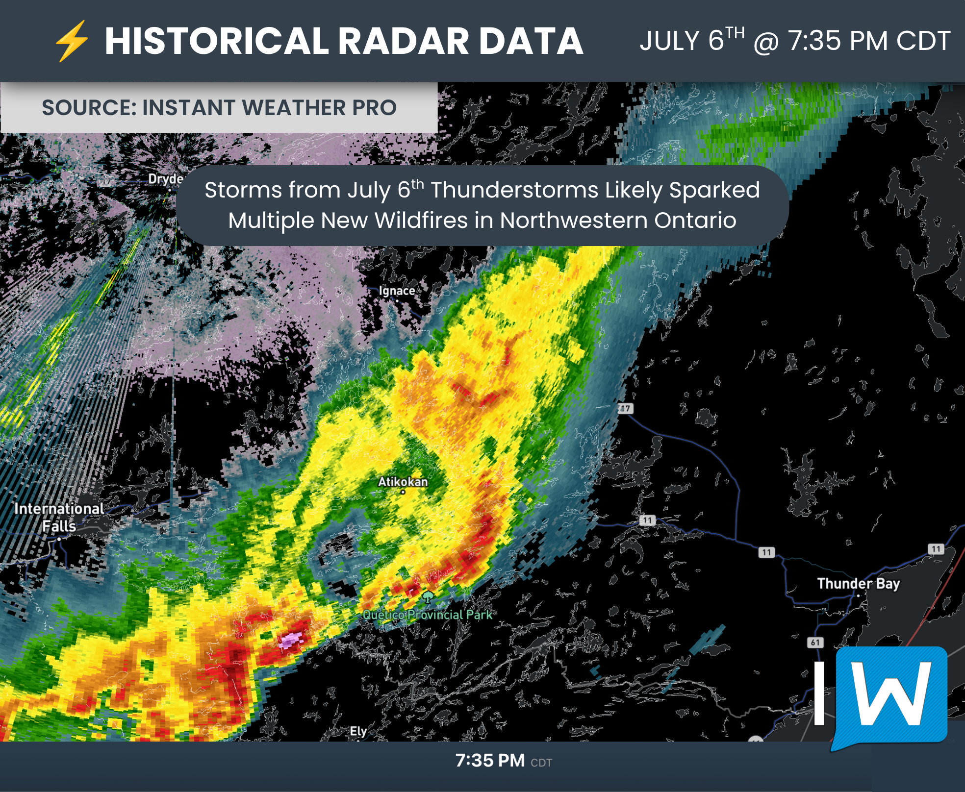
Multiple fires were already burning across Northern Ontario during the first week of July, but the situation deteriorated rapidly following a series of lightning strikes produced by thunderstorms that moved across Northwestern Ontario on July 6th and 12th.
A lightning strike does not necessarily cause a tree or surrounding vegetation to immediately erupt into visible flames. An ignition can instead smoulder underground, inside a tree or within dry vegetation for several days before warmer, drier and windier weather allows it to spread.
These are known as holdover fires. They can remain difficult to detect until conditions become favourable enough for them to grow and produce a visible smoke column.
The critical change in conditions arrived on Monday, July 13, when Northwestern Ontario entered a period of extreme heat. Afternoon temperatures climbed into the low to upper 30s while relative humidity fell below 30 percent and winds gusted upwards of 50 km/h.
Wildland firefighters sometimes use the “30-30-30 rule” as a quick indicator of weather capable of supporting extreme fire behaviour. The rule refers to temperatures of at least 30°C, relative humidity of 30 percent or lower and winds of at least 30 km/h. A related warning sign occurs when the temperature rises above the relative humidity value, a situation commonly referred to as crossover conditions.
This combination rapidly dries vegetation, allows flames to spread more quickly and makes direct suppression increasingly difficult and dangerous. Fires can begin crowning through treetops, throwing embers well ahead of the main fire and advancing several kilometres over a short period.
Many parts of Northwestern Ontario reached or exceeded these thresholds beginning Monday. As the extreme heat, low humidity and strong winds have continued on Tuesday and Wednesday, so has the explosive growth of fires across the region.
Not every fire currently burning was caused by the July 6 lightning. Some of the region’s largest fires were detected before then, including Dryden 13 on May 31 and Fort Frances 14 and 15 on June 30. However, holdover fires, along with sparks from the existing fires, may have contributed to the sudden increase in new fire discoveries as conditions have deteriorated over the past few days.
Could Provincial Funding Have Affected the Response?
The scale of the emergency is renewing scrutiny of how Ontario funds its forest firefighting program and whether chronic underbudgeting has limited the province’s ability to prepare proactively for severe fire seasons.
Ontario’s 2026 budget allocates $150 million to Emergency Forest Firefighting. That is $121 million less than the $271 million the province estimates it spent during the 2025-26 fiscal year, representing a reduction of approximately 45 percent compared with last year’s actual spending.
However, the $150-million allocation is $15 million higher than the province originally budgeted for the program last year. The annual budget is also not necessarily a firm spending limit, as additional emergency funding can be approved when wildfire suppression costs exceed the initial allocation.
The broader base budget for the Ministry of Natural Resources is projected to decline from $795 million to $739.5 million, a reduction of $55.5 million. (Ontario’s 2026 Budget)
Experts argue that relying on additional funding after a wildfire emergency has already intensified makes it more difficult to plan and position sufficient resources before multiple fires begin competing for the same crews, helicopters and equipment.
Wildland firefighter and union representative Noah Freedman told the National Observer that insufficient upfront funding can leave the province scrambling to request additional resources after conditions deteriorate.
According to Freedman, logistical problems during the 2025 fire season included a lack of available crews and helicopters in areas where they were needed. He argued that the funding structure can delay resource acquisition and prevent local officials from making proactive decisions before an emergency escalates. (Ontario Association of Fire Chiefs)
Those concerns are particularly relevant during a lightning-driven outbreak. The opportunity to contain a new fire is often greatest while it is still small. If crews or aircraft cannot reach it quickly, a period of hot, dry and windy weather can allow the fire to grow beyond the point where direct suppression is safe or effective.
It is not possible to determine whether a larger initial operating budget would have changed the outcome of any individual fire burning in Northwestern Ontario. The extreme weather experienced this week can produce fire behaviour capable of overwhelming even a well-resourced response.
The decision to withdraw crews from an actively burning area may also be based entirely on immediate safety conditions, rather than staffing or funding. When a fire begins crowning through the treetops, producing long-range embers or advancing rapidly, crews may have no safe option but to retreat.
Still, upfront funding can influence how many crews and aircraft are available, where those resources are positioned and how quickly officials can respond when numerous fires ignite or intensify simultaneously. The current emergency will likely bring further examination of whether Ontario entered the season with enough resources immediately available.
Widespread Evacuations Underway
The rapidly deteriorating conditions have prompted mandatory evacuations across several parts of Northwestern Ontario.
Communities under evacuation orders include Armstrong, Namaygoosisagagun First Nation (Collins First Nation), Gakijiwanong Anishinaabe Nation (Lac La Croix First Nation), Gull Bay First Nation, Lac des Mille Lacs First Nation and Whitesand First Nation.
Evacuation orders are also in effect for the townships of Hutchison, Ramsay Wright, Trottier and Weaver in the Dryden-Fort Frances-Atikokan District.
Cat Lake First Nation, a remote fly-in community surrounded by several fires, was also placed under a mandatory evacuation order Wednesday afternoon.
Fort Hope First Nation, also known as Eabametoong First Nation, and Aroland First Nation have both announced on Wednesday evening that they are evacuating as fires threaten the surrounding area.
Evacuating remote and fly-in communities presents significant logistical challenges. Residents cannot always leave by road, making aircraft availability, safe flying conditions and suitable accommodations in host communities critical parts of the operation.
Authorities have also placed several communities and areas on evacuation standby as the fires continue to spread. These include Ignace, Pickle Lake, Quetico, Crystal Lake, Atikokan, Niobe Lake and Upsala.
Being placed on standby does not mean an evacuation has been ordered. However, residents should prepare to leave quickly if conditions deteriorate. This includes gathering essential medications, identification, important documents, clothing and supplies, along with arranging transportation where necessary.
Residents should closely monitor instructions from local officials and emergency services.
Dryden 13 Devastates Collins First Nation
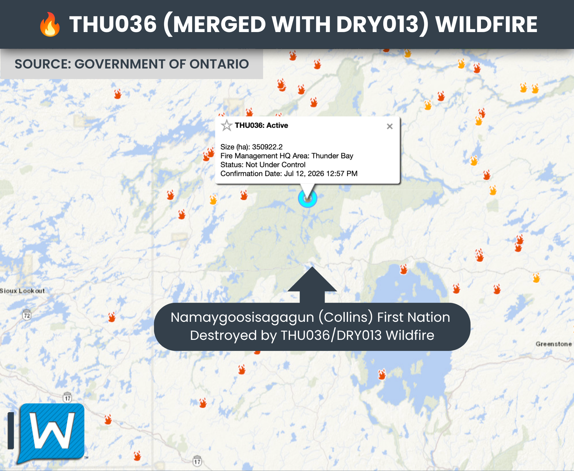
Dryden 13, also known as DRY013, was first detected on May 31 and has been affecting the Collins, Armstrong and Whitesand First Nation area.
The fire was classified as being held at approximately 14,333 hectares as of June 21. However, the return of hot and dry conditions caused it to grow significantly this week. Its current size remains unclear; however, there are indications that Dryden 13 may have advanced by as much as 50 kilometres on Monday, demonstrating the extreme rate of spread possible under the conditions experienced this week.
The fire advanced rapidly toward Namaygoosisagagun First Nation, also known as Collins First Nation, causing extensive damage and destruction to homes and other buildings. The complete extent of the losses remains unclear, but reports from the community indicate that much, or potentially most, of Collins has been destroyed.
Residents were reportedly forced to flee without the immediate support of emergency services, although all community members had been accounted for based on information available Wednesday morning.
Source: Ontario MPP Sol Mamakwa via X
The fire has also burned along the railway corridor near Armstrong. Horrifying video recorded from inside a CN freight train showed flames burning intensely on both sides of the tracks. Thankfully, the train crew was later safely evacuated.
In their Wednesday evening update, the Ministry of Natural Resources has confirmed that Dryden 13, along with several Thunder Bay fires, have merged with the much larger Thunder Bay 36 fire. This fire has been mapped at just over 350,000 hectares in size and is located within Wabakimi Provincial Park.
Fort Frances 14 Threatens Upsala Area
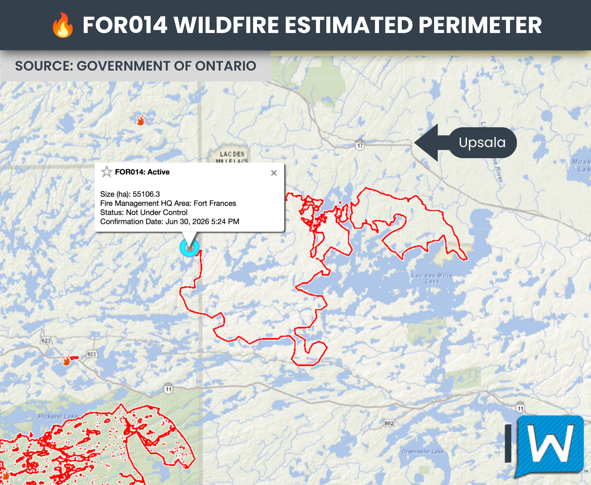
Fort Frances 14, or FOR014, was detected on June 30 and is burning between Highways 11 and 17 in the Upsala and Lac des Mille Lacs area.
The fire reportedly doubled in size overnight from Tuesday into Wednesday. Earlier Wednesday, the Ministry of Natural Resources announced that the fire had been mapped at 18,102 hectares. However, the province’s online fire map later listed its size at 55,106 hectares. It is unclear whether that difference reflects further growth, improved mapping or an adjustment to the estimated perimeter.
Lac des Mille Lacs has lost power as the fire continues to threaten the surrounding area. An emergency meeting was scheduled in Upsala for Wednesday evening, with the possibility of an evacuation expected to be among the issues discussed.
There are also two other fires southwest of Ignace, Dryden 28 and Dryden 36, adding to the increasingly complex situation in the region.
Fort Frances 15 Burns Through Quetico
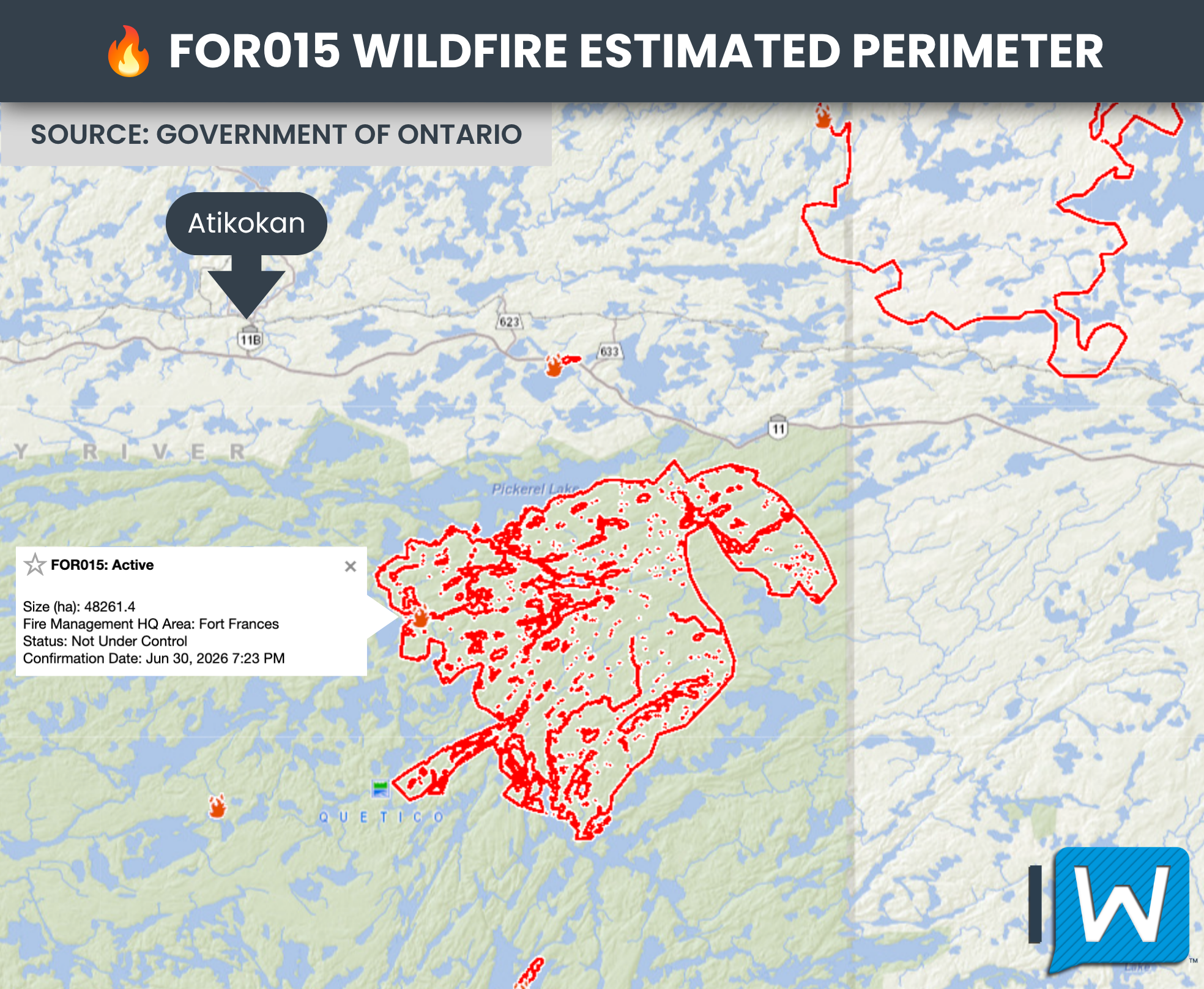
Fort Frances 15, or FOR015, is burning entirely within Quetico Provincial Park.
The fire was reported at 11,961 hectares earlier Wednesday, but the provincial fire map later listed it at 48,261 hectares. As with Fort Frances 14, it is unclear whether the substantial difference is the result of rapid growth or updated mapping.
Several other fires are also burning within Quetico Provincial Park and along the Highway 11 corridor, including Fort Frances 36 and Fort Frances 38.
Areas of Quetico Provincial Park have been evacuated or closed, affecting backcountry campers and paddlers. The fires are burning in remote terrain where access is limited, further complicating suppression efforts.
The Ministry of Natural Resources has reportedly withdrawn crews from the Ignace and Quetico fires because of extreme fire behaviour. Crews may be repositioned to protect communities and infrastructure or wait for conditions to become safe enough for suppression work to resume.
Minnesota Fires Cross Into Canada
The wildfire emergency extends beyond Ontario, with numerous lightning-caused fires also burning in Northern Minnesota and the Boundary Waters Canoe Area Wilderness.
U.S. fire officials reported that the Bear Trap Fire and Thumb Fire crossed the international border into Canada after exhibiting active or extreme fire behaviour.
The Thumb Fire is burning approximately 10 kilometres south of Gakijiwanong Anishinaabe Nation, also known as Lac La Croix First Nation. Aircraft have continued suppression efforts on the American side while Canadian authorities respond to the portions that have entered Ontario.
The international border has no effect on the spread of a wildfire, making coordination between Ontario and Minnesota authorities critical as fires threaten communities, parks and remote wilderness areas on both sides. (Minnesota Incident Command System)
Highway Closures Complicate Evacuations
Wildfires have affected several major transportation corridors across Northwestern Ontario.
As of 8 PM on July 15th, Highway 599 remains closed between Highway 516 and Mishkeegogamang First Nation, while Highway 527 is closed between Gull Bay First Nation and Armstrong.
Highway 11 was closed between Highways 633 and 623 along the northern edge of Quetico Provincial Park. That section has since reopened, although wildfire crews and emergency equipment may still be operating in the area. Officials continue to ask motorists to avoid non-essential travel.
These closures can significantly complicate evacuations because many Northwestern Ontario communities have few practical alternate routes. They can also disrupt the movement of emergency personnel, firefighting equipment, food, fuel and other critical supplies.
Smoke Spreads Across Eastern North America
The effects of the Northwestern Ontario wildfires are being felt thousands of kilometres away, as enormous quantities of smoke spread across the Great Lakes and into Eastern North America.
Closer to the fires, smoke has choked portions of Thunder Bay and surrounding areas. At times, it has become thick enough to nearly block out daylight, creating dark and almost apocalyptic scenes during the middle of the day.
The plume began flowing southeastward Tuesday, spreading across the Great Lakes into Southern Ontario, Quebec and the northeastern United States.
Some of the smoke initially remained above ground, but it still affected the weather by limiting the amount of sunlight reaching the surface. This appears to have reduced daytime heating and atmospheric instability, helping suppress what had previously been expected to be a potent severe thunderstorm threat across parts of Eastern Ontario, Quebec and New England on Tuesday.
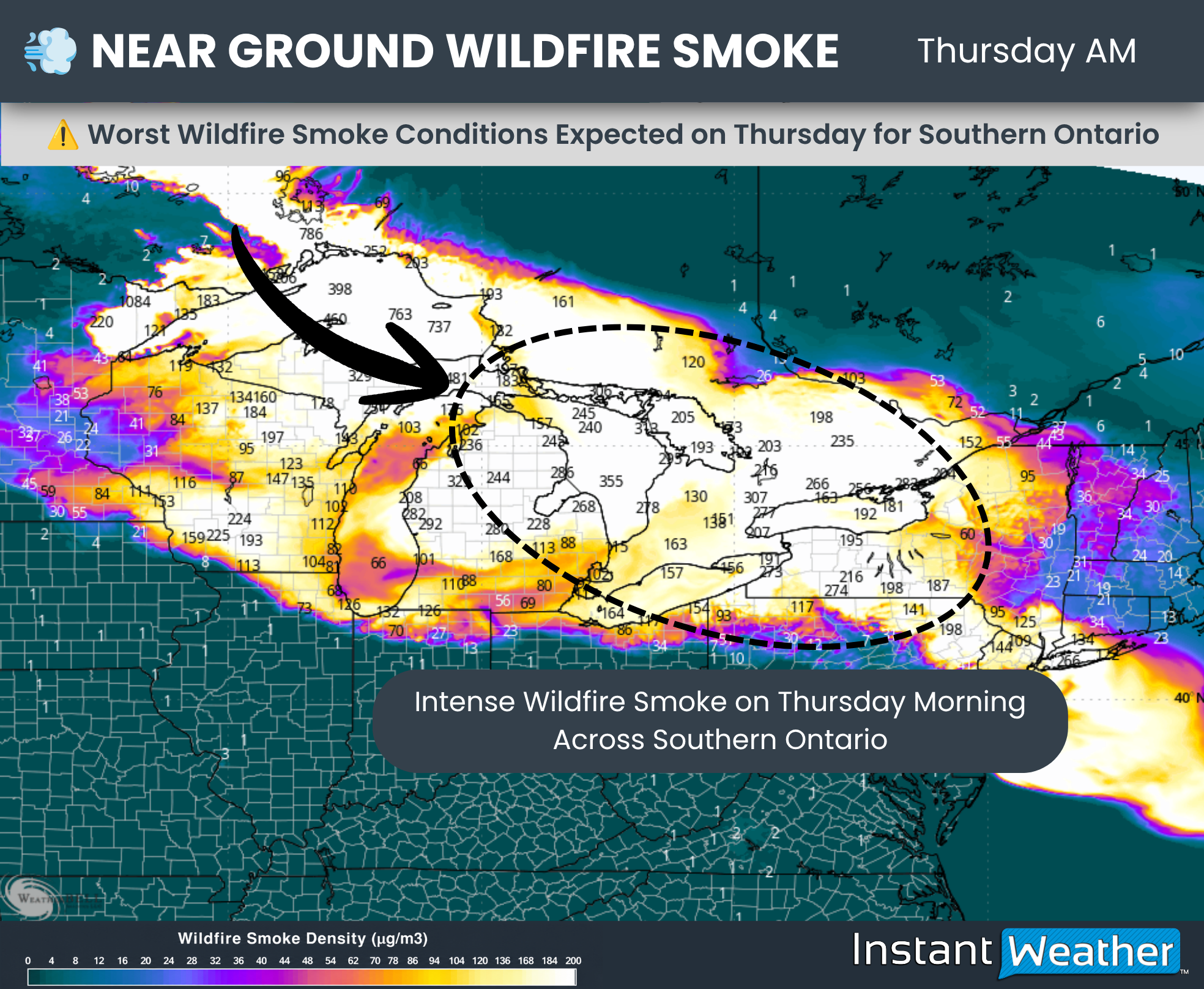
By late Tuesday, the smoke had begun mixing down to ground level across Southern Ontario. Conditions continued to deteriorate Wednesday as an even thicker plume arrived.
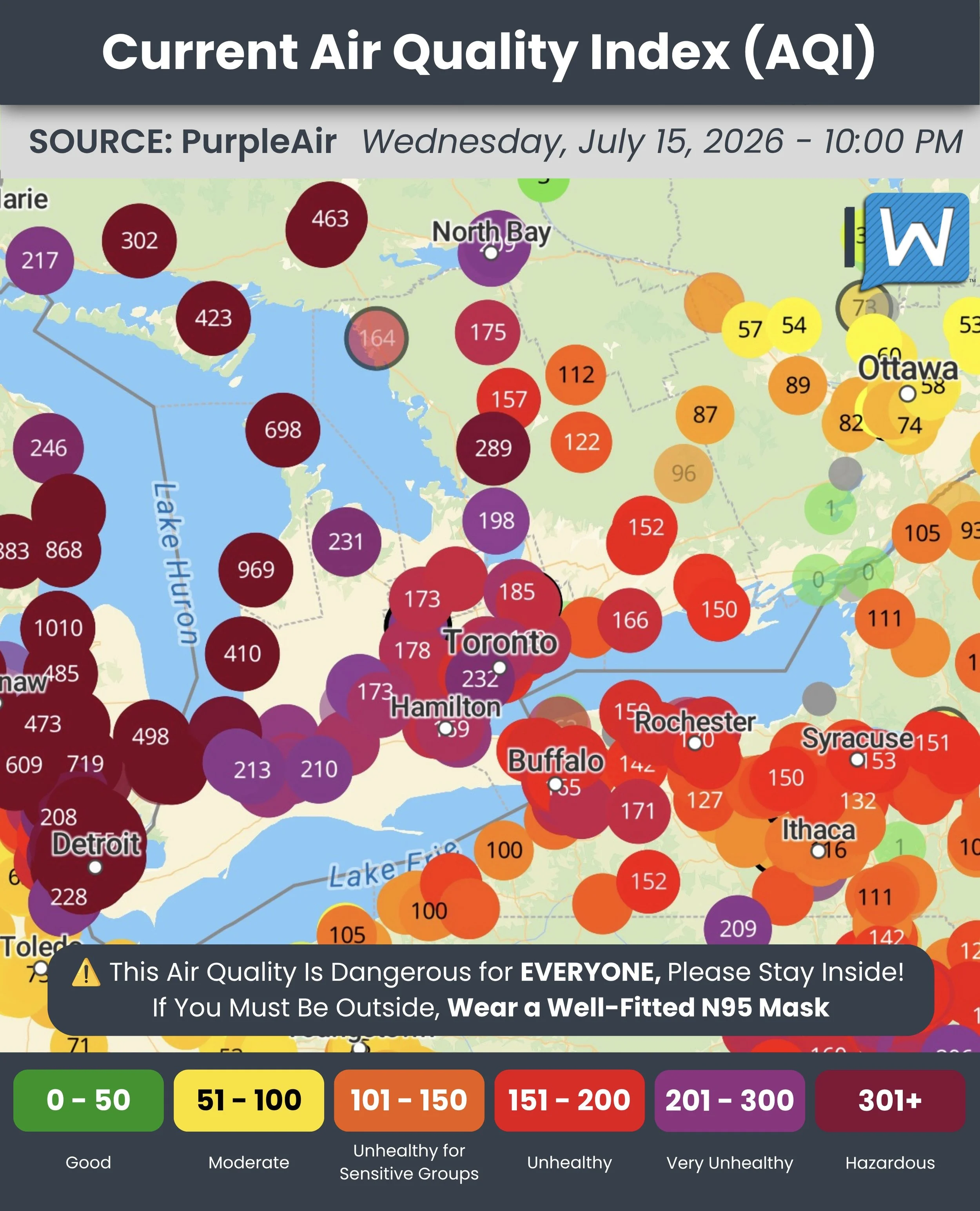
DATA FROM PURPLEAIR
This resulted in some of the worst air quality Southern Ontario has experienced in years. Official Air Quality Health Index readings reached the very high-risk category of 10+ in several communities.
Third-party sensors reported U.S.-scale Air Quality Index values approaching or exceeding 300 to 500 in parts of Southwestern Ontario and the Golden Horseshoe. Values in that range are considered very unhealthy to hazardous.
Toronto was also ranked as having some of the worst air quality among major cities worldwide Wednesday as smoke blanketed the region. (Ontario Air Quality Health Index)
DATA FROM WEATHERBELL
The worst conditions across Southern Ontario are expected to peak between late Wednesday and Thursday afternoon. Some smoke will likely linger into Friday and potentially the weekend, although its intensity and duration will depend heavily on fire behaviour and wind patterns over the next 24 to 48 hours.
Staying Safe During Hazardous Air Quality
Wildfire smoke contains fine particulate matter known as PM2.5. These particles are small enough to travel deep into the lungs and enter the bloodstream, potentially aggravating asthma, heart disease and other respiratory or cardiovascular conditions.
Children, older adults, pregnant people, those with heart or lung conditions and anyone working or exercising outdoors face an increased risk. However, smoke this intense can cause symptoms even in otherwise healthy people.
Residents should reduce or postpone strenuous outdoor activity and spend as much time as possible in a location with cleaner, filtered air. Keep windows and doors closed where it is safe to do so, set central air systems to recirculate and use the highest-quality filter the system can safely accommodate. A portable air purifier with a HEPA filter can also help reduce smoke particles indoors.
However, anyone without air conditioning should not allow their home to become dangerously hot simply to keep smoke outside. If indoor temperatures become unsafe, consider visiting a public cooling centre, library, shopping centre or another air-conditioned location with cleaner air.
Anyone who must go outside should consider wearing a properly fitted N95, KN95 or KF94 mask. Cloth and loose-fitting surgical masks provide little protection against the fine particles in wildfire smoke.
Watch for symptoms including coughing, wheezing, headaches, dizziness, eye or throat irritation, shortness of breath and chest discomfort. Anyone experiencing severe difficulty breathing, chest pain or another medical emergency should seek immediate medical assistance. (Health Canada wildfire smoke guidance)
With extreme fire behaviour continuing across Northwestern Ontario, the full extent of the emergency may not be known for some time.
Fire sizes can change dramatically when officials receive new satellite data or more accurate aerial mapping. This may explain some of the substantial differences between fire sizes announced earlier Wednesday and those later displayed on the provincial fire map.
Weather conditions over the next several days will play a major role in determining whether crews can regain control. Cooler temperatures, higher humidity and lighter winds would help reduce fire behaviour, but meaningful rainfall may be needed to provide more substantial relief.
Fire sizes, classifications, road closures, air quality conditions and evacuation orders may change rapidly. Residents in affected areas should continue following instructions from local officials and emergency services.