Arctic Blast Across Canada With Potentially Coldest Air in Years; Dangerous Wind Chills Near -40°C Possible Next Week
/Get ready for a major Arctic chill as some of the coldest air in over a year is set to spread across much of Canada over the next week.
This icy blast will originate in the Arctic and surge into Central and Eastern Canada, causing temperatures to plummet to dangerously low levels. Wind chills could drop to between -30°C and -40°C—or even lower—in several regions by early next week.
This extensive polar plunge will impact much of Canada and even stretch into parts of the United States. Over the next five to seven days, nearly everyone will feel the chill in some capacity.
The Prairies will be the first to experience this frigid air as it arrives late Friday into Saturday. By early next week, the cold will spread eastward into Ontario, Quebec, and Atlantic Canada, blanketing nearly all of the country in sub-zero temperatures. The cold snap is expected to last for a few days, but relief will arrive with more seasonal air by mid to late next week.
SATURDAY
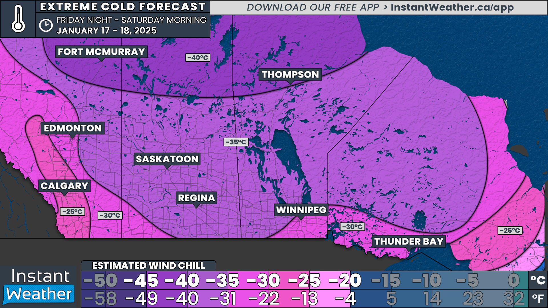
In Alberta, Saskatchewan, and Manitoba, the cold will start to settle in Friday night and intensify into Saturday morning. Temperatures will plunge below -20°C and could approach -30°C in some areas, even before factoring in the wind chill.
The coldest conditions will hit northern areas like Fort McMurray and Thompson, where wind chills could make it feel like -40°C to -45°C.
Most of Saskatchewan and Manitoba, excluding Winnipeg, will see wind chills between -35°C and -40°C. Winnipeg and Edmonton will feel slightly less severe, with wind chills in the low to mid -30s, while Calgary will range from -25°C to -30°C.
Northern Ontario will also begin to feel the chill, with wind chills making it feel close to -30°C in places like Thunder Bay by Saturday morning.
Meanwhile, Southern Ontario will enjoy one last relatively mild day on Saturday, with temperatures near the freezing mark. However, the arrival of the Arctic air could bring a flash freeze late Saturday in Northeastern and Southern Ontario. Rapidly dropping temperatures may lead to icy road conditions, so caution is advised.
SUNDAY
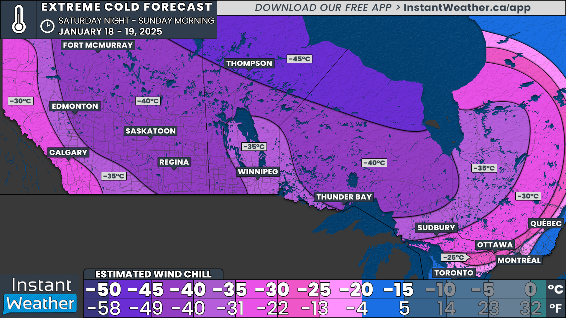
By Sunday morning, the cold air will deepen across the Prairies, bringing wind chills into the -40s for much of Saskatchewan and Manitoba. This includes locations like Edmonton, Fort McMurray, Saskatoon, Regina, and Thompson.
Winnipeg and Calgary will be slightly less frigid, with wind chills closer to -30°C to -35°C, though colder temperatures are expected by Monday morning.
Ontario will also see temperatures drop sharply by Sunday morning. Northern Ontario will experience bitterly cold air, with actual temperatures between -20°C and -30°C and wind chills closer to -40°C in the northernmost areas.
Southern Ontario will see temperatures ranging from -10°C to -20°C, with the coldest air in Central and Eastern Ontario. Wind chills in Northern sections of Southern Ontario could approach -30°C, while Southwestern Ontario and the Golden Horseshoe will feel like -20°C to -25°C.
The arrival of Arctic air could also reignite lake-effect snow squalls early next week. Snowbelt regions around Lake Superior, Lake Huron, and Georgian Bay could see heavy snowfall as a result. More details on this will be provided in a separate forecast.
STAYING SAFE IN THE EXTREME COLD
(Forecast continues below)
Extreme cold can pose significant risks to safety and health, especially when wind chill intensifies the freezing temperatures. Even moderate wind speeds can dramatically lower the "feels like" temperature, increasing the risk of frostbite.
When wind chill drops below -27°C, exposed skin can freeze in 30 minutes or less. At extreme levels, such as -40°C or colder, frostbite can occur in as little as 5-10 minutes.
To protect yourself and your loved ones, limit time spent outdoors during these dangerous conditions. If you must go outside, dress in multiple layers of loose-fitting, insulated clothing.
Make sure to cover all exposed skin with hats, scarves, gloves, and insulated boots. A windproof outer layer is essential to reduce the effects of cold winds.
Pay attention to frostbite warning signs, including numbness, tingling, or a loss of colour in fingers, toes, nose, or ears. If you suspect frostbite, immediately move to a warm location and avoid rubbing the affected area, as this can worsen tissue damage.
Hypothermia is another serious concern; symptoms include shivering, confusion, and slurred speech. Seek medical attention if hypothermia or frostbite is suspected.
For those driving during extreme cold, always keep an emergency kit in your vehicle with essentials such as blankets, extra clothing, food, and water.
Ensure your phone is fully charged, and let someone know your travel plans. Avoid leaving pets outdoors for extended periods, as they are equally susceptible to frostbite and hypothermia.
MONDAY
The worst of the cold will likely occur Monday morning, especially in the west, with Arctic air entrenched across much of Central and Eastern Canada. Temperatures near or below -30°C will stretch from Alberta to Western Quebec.
Wind chills could make it feel like -40°C or colder across Saskatchewan, Manitoba, Northern Ontario, and parts of Eastern Alberta and Western Quebec. Calgary and Edmonton will escape the worst, but wind chills will still hover around -35°C.
In Southern Ontario, most areas will see temperatures near -20°C, with Central and Southwestern Ontario experiencing the coldest air. Wind chills will make it feel like -25°C to -35°C, a pattern also expected in Montreal and Quebec City.
Atlantic Canada will begin to feel the polar plunge by Monday morning. Wind chills will drop to around -25°C in Northern New Brunswick, while Prince Edward Island and Nova Scotia will remain slightly milder, with wind chills ranging from -5°C to -15°C.
TUESDAY
By Tuesday morning, the coldest air will shift further east, bringing some relief to the Prairies. Alberta will see temperatures climb back into the single digits, with wind chills in the teens.
Eastern Saskatchewan will remain colder, with wind chills near -25°C to -30°C, while western regions warm slightly. Manitoba will also improve, though wind chills will still range from -30°C to -35°C, particularly near the Ontario border.
Tuesday is likely to be the coldest day for Ontario, as the Arctic air peaks over the province. Northern Ontario will see temperatures between -30°C and -40°C, with wind chills plunging well into the -40s.
Southern Ontario will experience temperatures from -20°C to -30°C, with wind chills making it feel like -35°C to -40°C in Central Ontario and the Ottawa Valley, and -30°C to -35°C elsewhere.
Montreal and Quebec City will endure similarly bitter conditions, with wind chills of -35°C or lower. Central and Western Quebec will feel even colder, with wind chills dropping below -40°C.
Atlantic Canada will also face its coldest morning on Tuesday. Wind chills will range from -35°C in Northern New Brunswick to the -20s in Nova Scotia and Prince Edward Island.
WEDNESDAY
Wednesday morning will bring one final bitterly cold start for much of Eastern Canada, but signs of improvement will begin to appear.
Southwestern Ontario, including Windsor, Sarnia, and London, could see wind chills near -35°C or even -40°C. Northern Ontario will finally climb above -30°C wind chills for the first time in days, marking the beginning of a warming trend.
Quebec will remain very cold, with wind chills near -40°C in some areas, while Montreal and Quebec City will continue to see wind chills of -35°C.
Atlantic Canada will face another cold morning, with wind chills between -20°C and -35°C.
Most of Eastern Canada will see a reprieve from the extreme cold by Thursday morning. However, this may only be temporary, as long-range models suggest another Arctic surge could arrive late next week into the weekend. Stay tuned for updates.


