End-of-Year Major Winter Storm to Bring Dangerous Ice Storm and Blizzard Conditions Across Southern and Northeastern Ontario Starting Sunday
/
Use Promo Code ‘Instant’ to Receive a Min. $25 Gift Card With Your Vacation!
NOTE: YOU CAN CLICK ON THE MAP TO OPEN A ZOOMABLE IMAGE
As we close out 2025, the final few days are shaping up to be very messy and potentially dangerous. A complex and powerful winter storm is expected to impact Ontario between Sunday and Monday, bringing ice storm conditions to a wide swath of Central, Eastern and Northeastern Ontario.
With significant and prolonged freezing rain expected, widespread and long-lasting power outages are likely in the hardest hit areas. Ice accretion of up to 20mm is possible, and unfortunately, the regions most at risk include many of the same areas that were hit hard by last March’s major ice storm. In some locations, the power grid remains fragile, which raises additional concern.
Further north, the story will shift to heavy snow across much of Northeastern Ontario. Long-lasting blizzard conditions are possible here, with snowfall totals potentially exceeding 50cm by the time the storm finally winds down on Tuesday.
This system will also bring the risk of severe wind gusts across both Southern and Northern Ontario on Monday. Areas closest to the shorelines of the Great Lakes will be at the greatest risk, with damaging wind gusts in excess of 90 km/h possible. There may even be some isolated pockets, mainly in the Niagara region, that approach 100 km/h.
Southwestern Ontario will be largely unaffected by the first phase of the storm. Temperatures here will rise steadily on Sunday, peaking in the double digits by late afternoon or evening. Rain will fall steadily through Sunday and into early Monday. However, conditions will change rapidly as temperatures plunge Monday morning, creating a potential flash freeze as all that rainfall quickly freezes on roads and other surfaces.
Later on Monday, strong wind gusts will combine with steady, moderate snowfall around Lake Huron and Georgian Bay. Blizzard conditions could develop during the afternoon and evening as visibility drops and blowing snow becomes intense.

PRECIP TYPE - MAP FROM WEATHERBELL
The storm will begin to take shape late Sunday morning as the first bands of precipitation spread into Northeastern Ontario and parts of Southwestern Ontario. This will initially include some light freezing rain extending from London through Kitchener and Barrie.
TEMPERATURE - MAP FROM WEATHERBELL
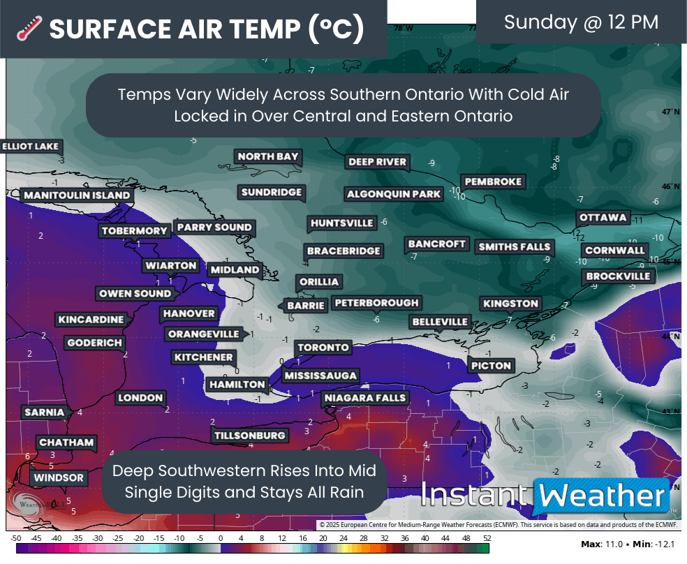
Sunday afternoon will be heavily dependent on the position of the freezing line, which is expected to slowly expand northeastward. Areas to the southwest will gradually climb above freezing and escape the worst of the icing, while regions farther northeast remain locked below zero.
By around midday, most of Central and Eastern Ontario is expected to remain well below freezing. Higher elevation areas northwest of the GTA will hover close to the freezing mark, including Hamilton, Kitchener, Guelph and Orangeville. How long the cold air remains trapped at the surface will play a major role in how impactful the icing becomes in places like the Kitchener area.
Meanwhile, Deep Southwestern Ontario, including Windsor, will already be sitting in the mid single digits. Heavy rain will be ongoing here, but there will be no winter storm impacts during the day on Sunday.
PRECIP TYPE - MAP FROM WEATHERBELL
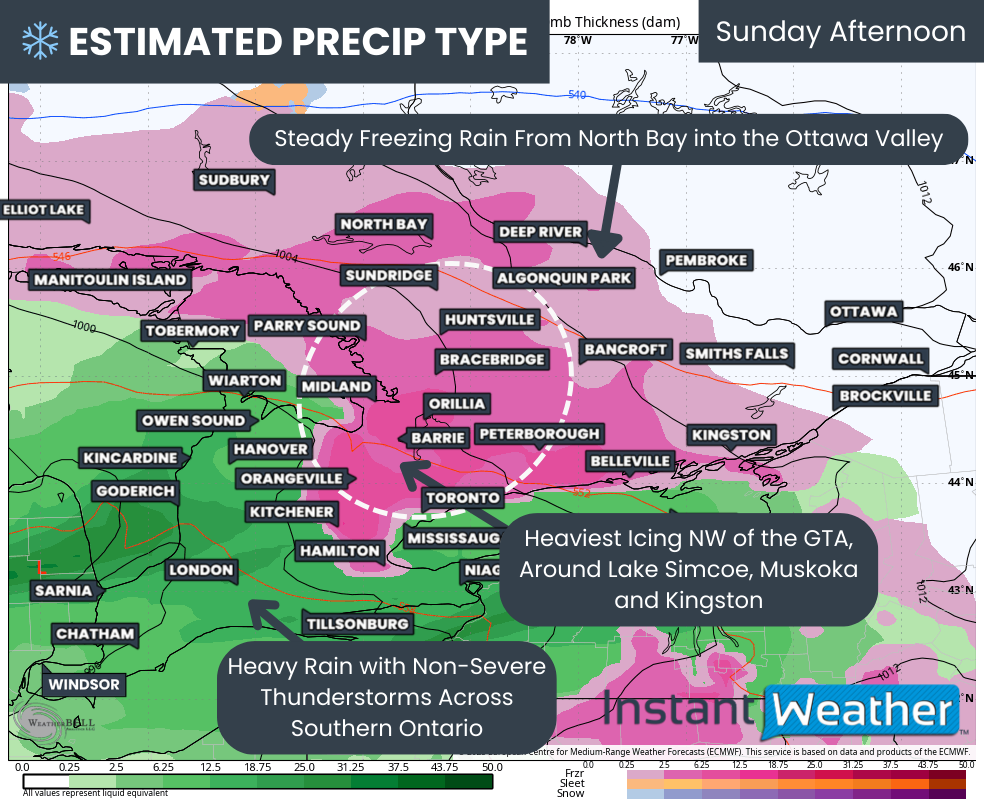
As Sunday afternoon progresses, the freezing rain shield will expand northward into the North Bay area and the Ottawa Valley. The heaviest icing during this time is expected to focus around Lake Simcoe.
Locations such as Bracebridge, Lindsay, Orillia, Peterborough, Barrie, York Region, Kitchener and Orangeville appear likely to see the worst icing on Sunday afternoon. Precipitation rates will be quite heavy, allowing ice to accumulate rapidly on roads, trees and power lines.
At the same time, Southwestern Ontario, including the Niagara region, will see heavy rain, with some embedded non-severe thunderstorms possible. Rainfall totals could be significant, with some localized areas exceeding 50mm by Monday morning.

At the same time, Southwestern Ontario, including the Niagara region, will see heavy rain, with some embedded non-severe thunderstorms possible. Rainfall totals could be significant, with some localized areas exceeding 50mm by Monday morning.
Flooding could be a concern as frozen ground has a lower ability to absorb the rain.
PRECIP TYPE - MAP FROM WEATHERBELL
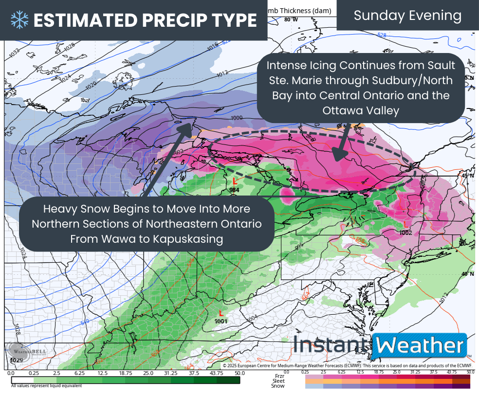
As we move into Sunday evening, the freezing rain zone will become very expansive as the system rapidly intensifies. Intense icing is expected from Sault Ste. Marie through Sudbury and North Bay and into Central and Eastern Ontario.
Meanwhile, colder and more entrenched air across Northeastern Ontario will allow precipitation to switch over to heavy snow. Areas from Wawa to Kapuskasing will see snowfall rates increase significantly.
TEMPERATURE - MAP FROM WEATHERBELL
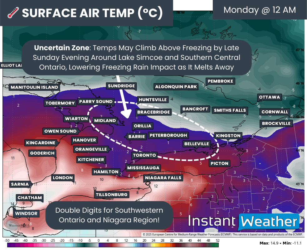
By late Sunday evening, uncertainty will increase across southern portions of Central and Eastern Ontario as temperatures hover very close to the freezing mark. This includes Barrie, Orillia, Muskoka, the Kawarthas, Peterborough and Kingston. If cold air proves even slightly more resilient than currently expected, these regions could remain below freezing overnight and continue to experience ice storm conditions.
In Deep Southwestern Ontario, it will feel almost surreal for late December, with temperatures climbing into the double digits even around midnight.
PRECIP TYPE - MAP FROM WEATHERBELL
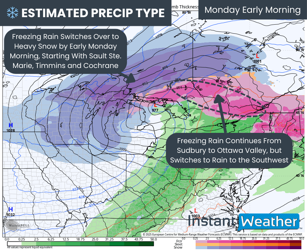
Overnight Sunday into early Monday, heavy snowfall will expand farther south across Northeastern Ontario as colder air continues to advance. Areas including Sault Ste. Marie, Timmins and the Cochrane corridor are expected to transition from freezing rain to heavy snow.
This transition is especially concerning for the power grid, as heavy snow may accumulate on top of ice-coated trees and power lines. That combination could lead to significant damage, particularly in more remote and heavily forested areas.
For the Sudbury to Ottawa Valley corridor, freezing rain is expected to continue through the overnight hours with ice accumulation steadily increasing. This region is likely to see some of the worst overall impacts due to the length of time spent under freezing rain.
TEMPERATURE - MAP FROM WEATHERBELL
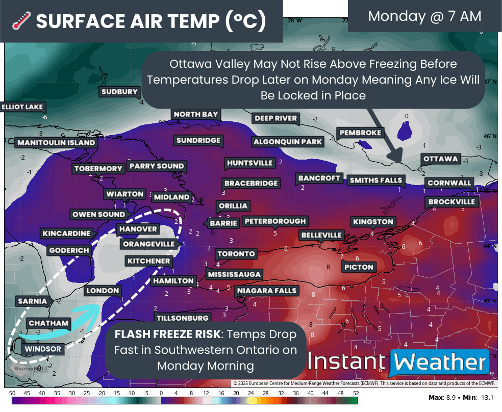
By late Monday morning, the next phase of the storm will unfold in the form of a flash freeze across Deep Southwestern Ontario. Rapidly falling temperatures will cause any remaining moisture to freeze quickly on untreated surfaces, creating extremely hazardous travel conditions.

NOTE: YOU CAN CLICK ON THE MAP TO OPEN A ZOOMABLE IMAGE
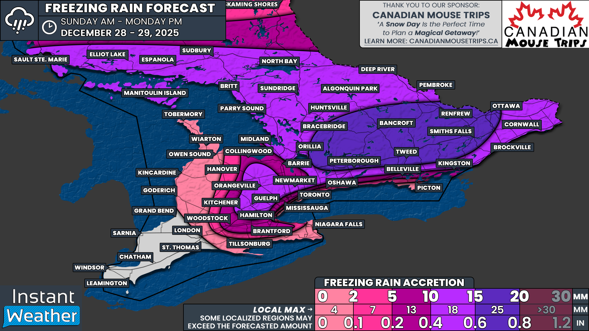
As freezing rain ends across Central and Eastern Ontario and temperatures drop by Monday afternoon, the true extent of the damage will become clear. Current data suggests the hardest hit areas may include Kawartha Lakes, Peterborough, Haliburton, Bancroft, Tweed, Kaladar, Renfrew, Perth and Ottawa. Ice accretion in these regions may range from 15 to 20mm, with localized pockets potentially approaching 25mm.
In the Ottawa Valley, temperatures may not rise above freezing at all before the flash freeze arrives. This would lock ice in place for an extended period, worsening impacts. Farther south, a brief window above freezing may help slightly reduce overall damage.
A broader area of Central and Eastern Ontario, along with higher elevations northwest of the GTA and parts of Northeastern Ontario, can expect between 10 and 15mm of ice. This includes Brockville, Kitchener, Guelph, Newmarket, Barrie, Muskoka, Parry Sound, North Bay, Sudbury and Sault Ste. Marie.
Ice amounts will decrease closer to Lake Ontario and away from higher terrain. Between 5 and 10mm is possible from Kingston through the northern GTA and higher elevations around Hamilton and Grimsby. Less than 5mm is expected for Oshawa, Mississauga, Hamilton and Meaford. Little to no icing is expected near Lake Huron and Lake Ontario, where temperatures remain above freezing for most of the event.
PRECIP TYPE - MAP FROM WEATHERBELL
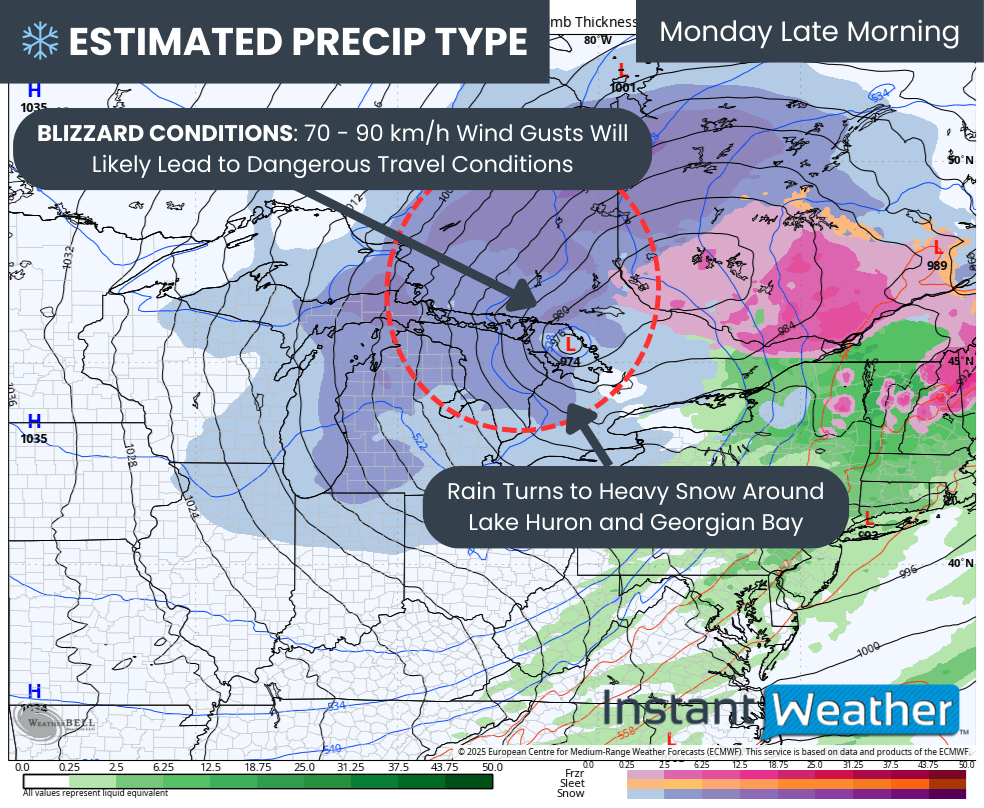
While freezing rain will end, hazardous conditions will continue. By late Monday morning, rain will change to heavy snow around Lake Huron and Georgian Bay. Strengthening winds of 70 to 90 km/h will create dangerous travel conditions and likely meet blizzard criteria.
Combined with the flash freeze, widespread road closures are likely east of Lake Huron and into Northeastern Ontario. Travel should be avoided in these regions.
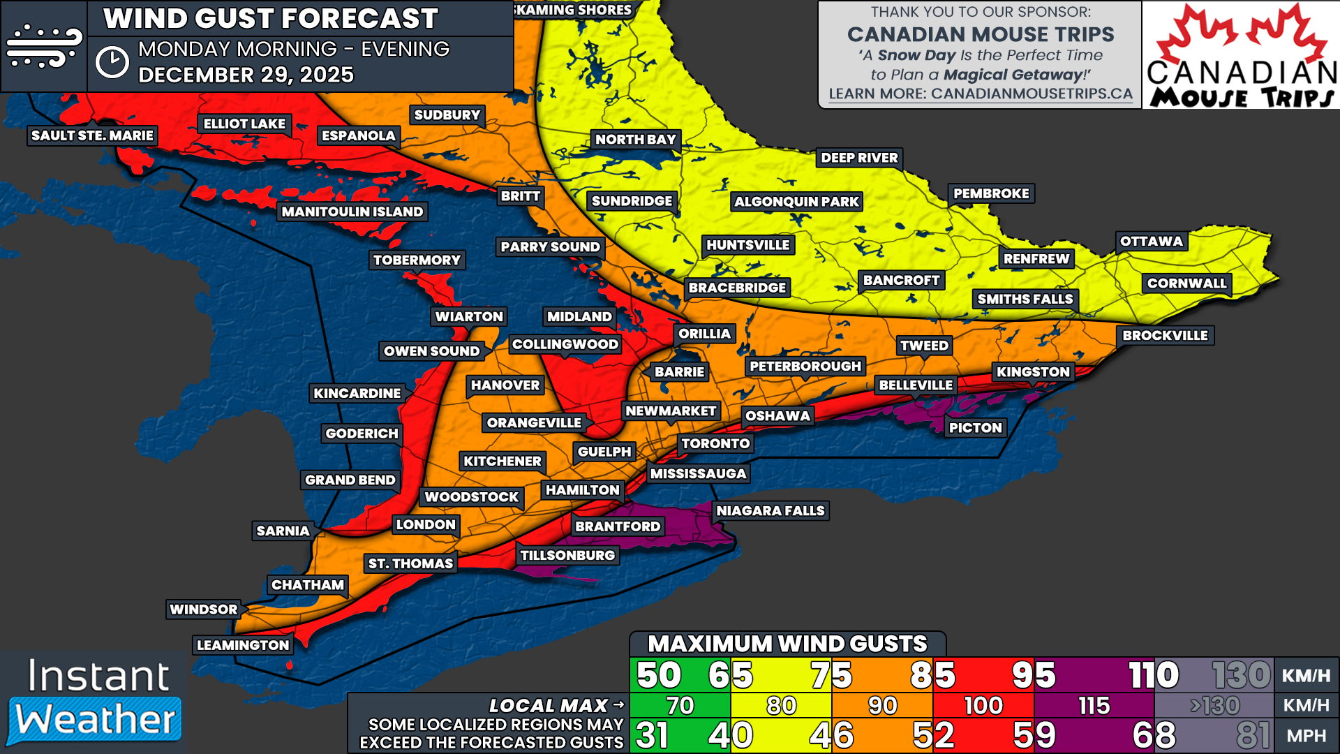
NOTE: YOU CAN CLICK ON THE MAP TO OPEN A ZOOMABLE IMAGE

The strongest wind gusts are expected during the morning and afternoon on Monday before slowly easing in the evening. Areas exposed to the lakes will see the worst winds, with gusts of 95 to 110 km/h possible across the Niagara region and into Prince Edward County.
Near damaging gusts of 85 to 95 km/h are possible along the Lake Ontario shoreline from Kingston through the GTA and Hamilton, as well as along the Lake Erie and Lake Huron shorelines and southeast of Georgian Bay into Simcoe County and Orangeville.
Elsewhere across Southwestern Ontario and southern portions of Central and Eastern Ontario, peak gusts of 75 to 85 km/h are expected. Farther north, including the Ottawa Valley, gusts will generally range from 65 to 75 km/h. While lower, these winds may cause greater damage due to occurring after significant ice accumulation.
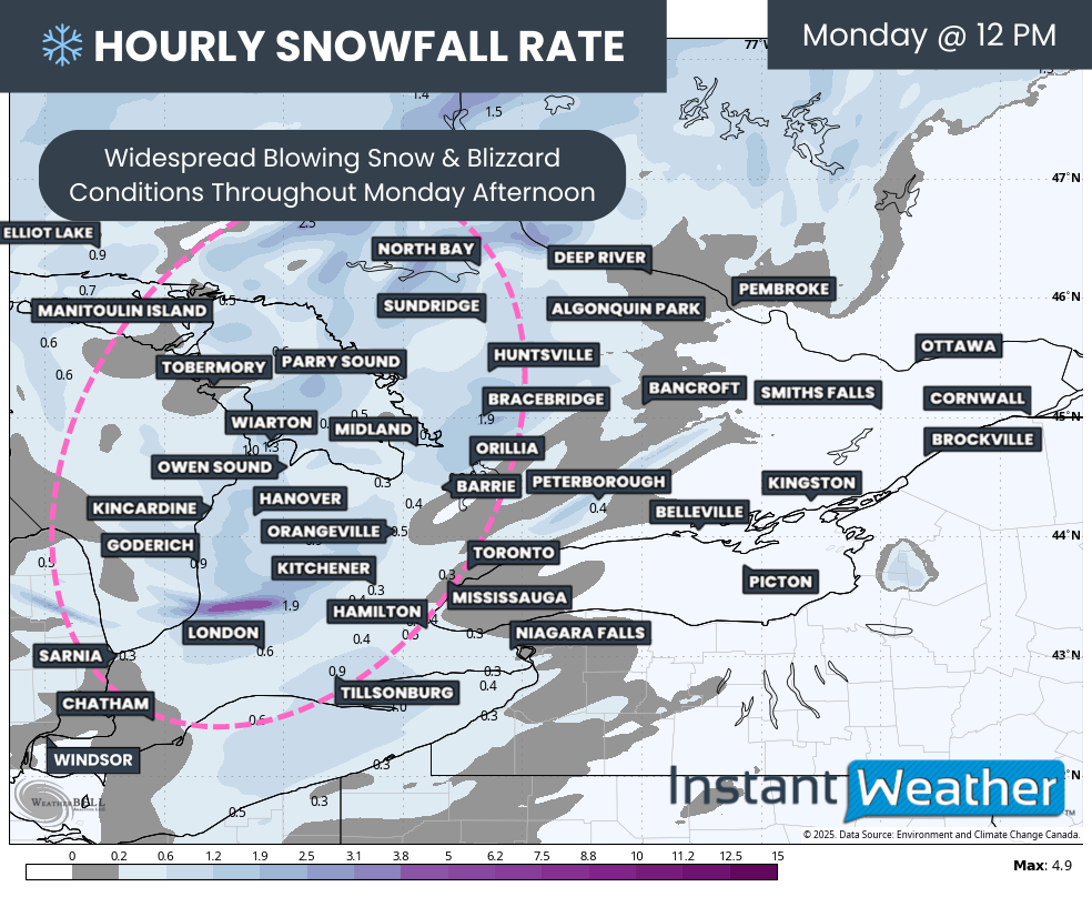
Hourly snowfall rates (cm) - MAP FROM WEATHERBELL
Conditions will remain treacherous through Monday afternoon with strong winds and persistent snowfall, especially near the lakes, where blizzard conditions continue.
NOTE: YOU CAN CLICK ON THE MAP TO OPEN A ZOOMABLE IMAGE
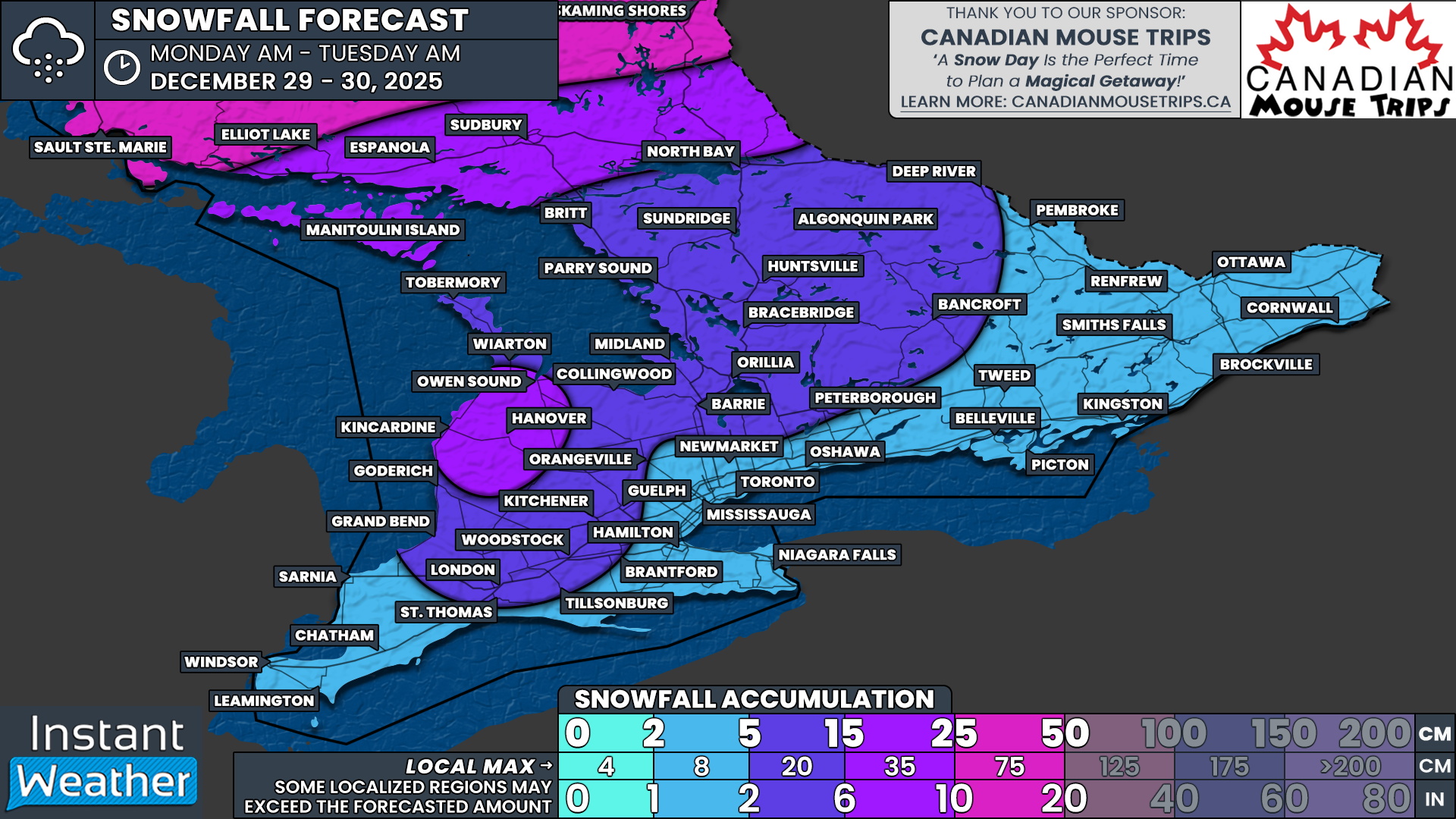
Snowfall totals associated with the main system will wrap up by Tuesday morning. Central Ontario and parts of Southwestern Ontario east of Lake Huron can expect 5 to 15cm of snow, with localized totals exceeding 15cm near Kincardine, Hanover and Owen Sound due to lake enhancement.
Elsewhere across Southern Ontario, snowfall amounts will generally range from 2 to 5cm.
NOTE: YOU CAN CLICK ON THE MAP TO OPEN A ZOOMABLE IMAGE
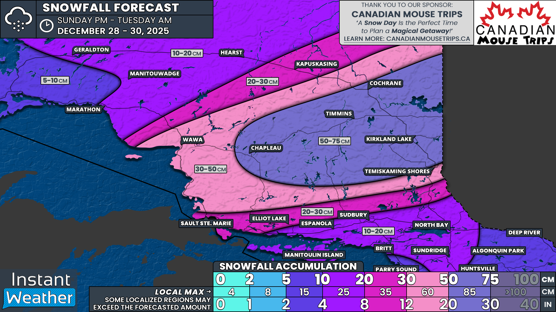
In Northern Ontario, snowfall totals will be far more significant. The highest amounts are expected in Cochrane, Timmins, Chapleau and Kirkland Lake, where totals of 50 to 75cm are possible between Sunday evening and Tuesday morning.
A broader swath of Northeastern Ontario, including Wawa and Temiskaming Shores, may see 30 to 50cm. Areas such as Elliot Lake, Sault Ste. Marie and Kapuskasing could receive 20 to 30cm, while North Bay, Sudbury and Manitoulin Island are expected to pick up between 10 and 20cm.


