Ice Storm Threat for Hamilton and Kitchener as Toronto and Barrie Face Snow and Icy Blast on Wednesday
/
NOTE: YOU CAN CLICK ON THE MAP TO OPEN A ZOOMABLE IMAGE

Get 20% off on stays until April when you book online with code: 20years
A significant and potentially high-impact winter storm is set to take aim at Southern Ontario throughout the day on Wednesday, bringing a messy and complicated mix of freezing rain, ice pellets and heavy snow.
This is shaping up to be a true multi-hazard event, and depending on your exact location, the impacts could look very different. Some communities will be dealing with hours of relentless freezing rain and dangerous ice buildup, while others will see bursts of heavy snow mixed with ice pellets.
While the specific precipitation type will vary substantially from region to region, the one thing that is nearly universal is the timing. This storm is expected to peak during the height of both the morning and afternoon commutes. That alone will be enough to create widespread travel headaches across highways, city streets and rural roads alike.
The main story with this system will likely be the corridor of significant freezing rain focused south and west of the Greater Toronto Area. This includes Hamilton through Kitchener and Guelph, along with Perth, Wellington, Dufferin, Grey and Bruce counties. These areas are in the prime zone for prolonged icing.
Six to twelve hours of freezing rain beginning in the early morning and continuing into the late afternoon will allow ice to quickly accumulate on untreated roads, sidewalks, driveways, trees and power lines. In some communities, total ice accretion could approach 10 to 15 mm. That is more than enough to create dangerous travel conditions and begin causing infrastructure issues.
To make matters worse, wind gusts are expected to range from 40 to 60 km/h, with some areas potentially seeing localized gusts of 70 to 80 km/h through the morning and afternoon. When you combine strong winds with heavy ice accumulation, the risk of power outages increases significantly. Ice weighing down tree branches and power lines does not need much additional force to snap, and scattered to potentially widespread outages are possible in the hardest hit areas.
Unlike some freezing rain events where temperatures eventually rise above zero and help melt some of the ice, this system is not expected to feature a meaningful warmup. Cold air at the surface is likely to remain locked in place until at least Thursday, and possibly even into Friday. That means once surfaces are coated in ice, they may stay that way for an extended period of time. This could prolong power outages and keep travel conditions poor well beyond Wednesday.
Freezing drizzle may also linger through the later part of Wednesday and into early Thursday across parts of Southwestern Ontario and the Golden Horseshoe. Even light drizzle can add a fresh glaze on top of existing ice, further worsening conditions and increasing the risk of slips, falls and vehicle collisions.
Further north and east, from around Lake Simcoe through Toronto, Peterborough and into Kingston, the focus shifts more toward a messy mix of ice pellets (sleet) and snow. While snowfall totals are not expected to be extreme, generally in the 5 to 15 cm range, the presence of ice pellets and occasional freezing rain will still make for slick and hazardous conditions.
PRECIP TYPE - MAP FROM WEATHERBELL
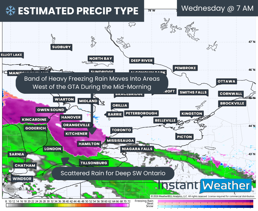
Based on the latest model guidance, the first band of precipitation will arrive in Deep Southwestern Ontario during the early morning hours. Areas like Windsor, Sarnia and Chatham will be well above freezing, so precipitation here will fall mainly as rain.
As that precipitation spreads northeast through the morning, it will encounter below-freezing temperatures at the surface. That is where the transition to freezing rain will occur, with rain freezing on contact with cold surfaces. This swath of freezing rain is expected to expand as additional bands of precipitation move in through the mid-morning hours.
Conditions are likely to deteriorate quickly around Hamilton, Kitchener, Hanover and Owen Sound during the mid to late morning as steady freezing rain sets in. Roads may become icy in a short period of time, especially on untreated surfaces and elevated roadways such as bridges and overpasses.
By late morning, the freezing rain may edge into portions of Peel and York Region, along with Toronto. However, there remains some uncertainty with the temperature profile in these areas. It may begin as freezing rain but could quickly mix with or change to ice pellets and snow as colder air near Lake Simcoe resists the push of warmer air aloft. Even a few hours of freezing rain in the GTA during rush hour would be enough to cause significant delays and collisions.
PRECIP TYPE - MAP FROM WEATHERBELL
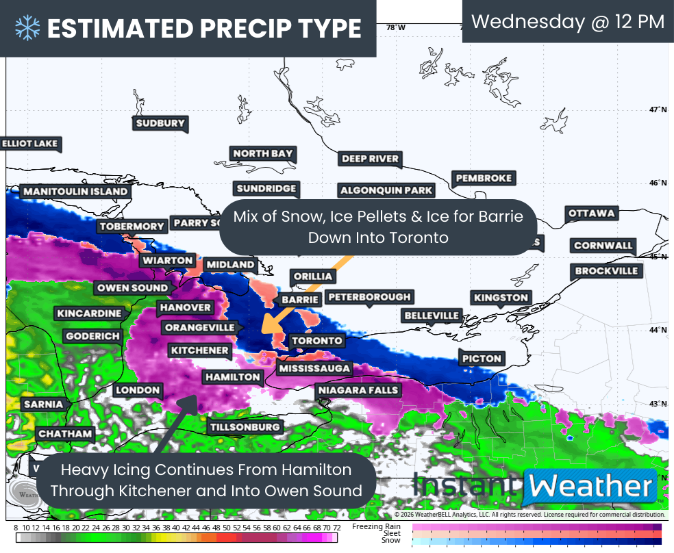
By around noon, snow and ice pellets are expected to reach Barrie, with that messy mix extending into Toronto. Meanwhile, freezing rain will likely remain steady and relentless from Hamilton through Kitchener and Hanover, continuing to build ice on trees and power lines.
One key factor we will be watching closely is the potential for temperatures to actually drop slightly through the morning in some areas. If that happens, communities around Niagara and into London could briefly dip below freezing and transition from rain to freezing rain, increasing the icing risk in those areas.
PRECIP TYPE - MAP FROM WEATHERBELL
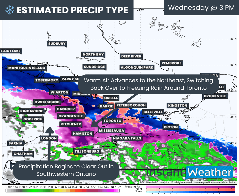
Through the early afternoon, the corridor of freezing rain is expected to remain largely locked in place. By this time, ice accretion on many surfaces could be reaching significant or even crippling levels in the hardest hit communities.
Additional bursts of moderate to heavy precipitation during the afternoon could further add weight to already stressed trees and power lines. If damage is going to occur, it is most likely to ramp up during this period.
There is some good news as precipitation should begin to clear out of Southwestern Ontario by mid-afternoon. Areas that experience the worst of the freezing rain should see it taper off by late afternoon, although the impacts will linger.
By mid-afternoon, the leading edge of the heavier snow is expected to reach Orillia and Peterborough. There remains some uncertainty on how far north and east the steadier snow will extend before weakening. Some model guidance pushes it as far as Muskoka and Kingston, while others keep the bulk of it closer to Lake Simcoe.
Heavy snow and ice pellets with localized blowing snow will continue through the afternoon in these areas. Closer to Toronto, warmer air aloft may briefly push back in, potentially causing a switch back to freezing rain late in the event. Unfortunately, this could line up closely with the afternoon commute, leading to significant travel disruptions.
If possible, it would be wise to delay travel during both the morning and afternoon peak periods. Icy roads, reduced visibility and the potential for downed branches or power lines could make conditions dangerous in a hurry.
PRECIP TYPE - MAP FROM WEATHERBELL
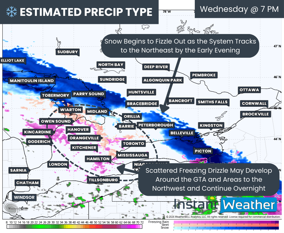
As the system weakens and begins to break apart over Central Ontario during the early evening, we may still see pockets of patchy freezing drizzle develop around the Golden Horseshoe and into Southwestern Ontario.
This includes many of the same areas hardest hit by earlier freezing rain. Even light drizzle could add additional ice and prolong impacts into Thursday morning, increasing the risk of school bus cancellations for a second consecutive day.

NOTE: YOU CAN CLICK ON THE MAP TO OPEN A ZOOMABLE IMAGE

Get 20% off on stays until April when you book online with code: 20years
When it comes to snowfall totals, there is some uncertainty due to the mixing with ice pellets. The heaviest swath of snow is most likely to extend from the northern tip of the Bruce Peninsula through Simcoe County and Southern Muskoka into the eastern GTA, Peterborough and Belleville area.
We are forecasting a general 5 to 15 cm for Barrie, Orillia, Gravenhurst, Lindsay, Port Perry, Peterborough, Cobourg, Belleville and Picton, with localized totals up to 20 cm possible if the system overperforms.
A similar 5 to 15 cm is forecast for Collingwood, Angus, Vaughan, Bradford, Newmarket, Toronto, Pickering and Oshawa. However, more mixing with ice pellets is expected in this zone, so totals may trend closer to the lower end of that range in many communities.
For Parry Sound, Huntsville, Haliburton, Tweed and Kingston, snowfall totals are expected to range from 2 to 5 cm. There is also a chance that some of these areas see very little accumulation if the storm weakens faster than currently projected.
Less than 2 cm of snow is expected across much of Eastern Ontario, including the Ottawa Valley.
To the west, snowfall totals will decrease as ice pellets and freezing rain become the more dominant precipitation types. We are forecasting 2 to 5 cm for Wiarton, Shelburne, Orangeville and Oakville, with less than 2 cm further southwest.
NOTE: YOU CAN CLICK ON THE MAP TO OPEN A ZOOMABLE IMAGE
Turning back to the freezing rain threat, the worst impacts are expected west of the Golden Horseshoe along the Hamilton through Kitchener to Owen Sound corridor.
Highest ice accretion is likely in Hamilton, Burlington, Cambridge, Kitchener, Listowel, Minto, Wingham, Mildmay, Port Elgin and Hanover. Ice storm conditions are possible here with 6 to 12 mm of icing, and localized pockets of 15 mm cannot be ruled out.
A zone including Owen Sound, Chatsworth, Arthur, Fergus and Guelph is also at risk for 6 to 12 mm of freezing rain accretion. There is some uncertainty here due to the potential mixing with ice pellets at times, especially late morning into early afternoon, which could limit totals somewhat.
Lower amounts of freezing rain are expected both to the southwest and northeast for different reasons.
To the southwest, more rain will mix in, limiting the duration of icing. Niagara on the Lake, St. Catharines, Woodstock, Clinton and Kincardine could see 2 to 6 mm of freezing rain, mainly during the latter part of the event as temperatures gradually slip below freezing.
Southern Niagara through Simcoe, Tillsonburg, London, Lucan and Goderich can expect less than 2 mm of freezing rain, with precipitation falling mainly as rain.
To the northeast, mixing with ice pellets will limit freezing rain totals. That includes Wiarton, Meaford, Orangeville, Brampton, Oakville, Mississauga and Toronto, where around 2 to 6 mm of freezing rain accretion is expected.
Less than 2 mm of icing is forecast for York Region and into Simcoe County, where snow and ice pellets should be the main precipitation types.
This is a complex and high-impact storm with significant variation over relatively short distances. We will continue to fine-tune these details as new data comes in, but now is the time to prepare for difficult travel, possible power outages and extended icy conditions across parts of Southern Ontario.


