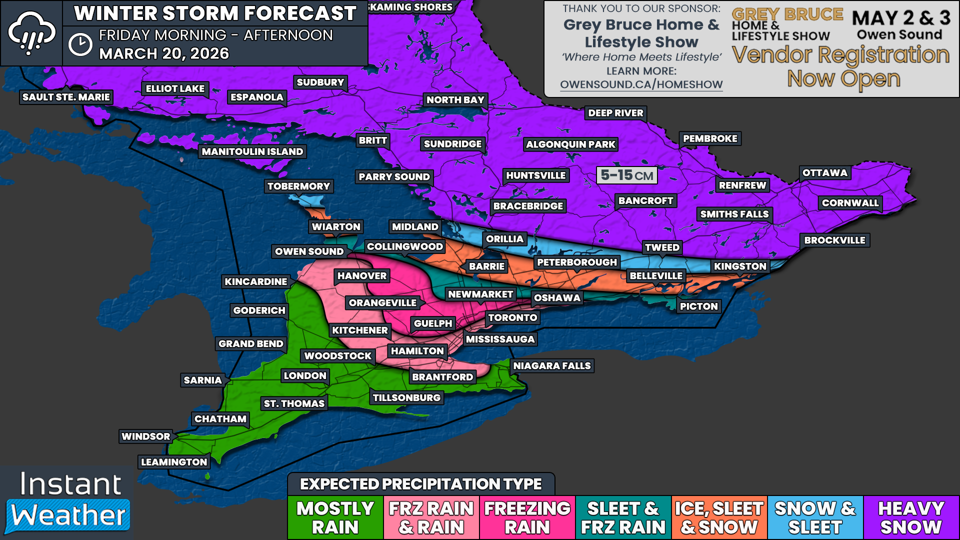
Winter Crashes the First Day of Spring, Snow and Ice to Disrupt Friday Commute in Southern Ontario
/
Interested in sponsoring a forecast? Apply Here
NOTE: YOU CAN CLICK ON THE MAP TO OPEN A ZOOMABLE IMAGE
With the official start of astronomical spring arriving on Friday, Southern Ontario is set to enter a weather roller coaster. It begins with a heavy burst of messy, mixed precipitation that could impact the Friday morning commute. At the same time, parts of Southwestern Ontario will welcome the first day of spring with double-digit temperatures, with some areas potentially flirting with the 20°C mark.
As temperatures begin to rise on Friday, a fast moving system will push across Southern Ontario ahead of the warmer air. With surface temperatures still below freezing early in the day, some of the precipitation will fall as snow, ice pellets, and even freezing rain.
While the heaviest precipitation will only last for a few hours, the timing could not be worse. It is expected to peak across Southwestern Ontario and the Golden Horseshoe during the mid to late morning hours. This will likely create slippery road conditions right in the middle of the morning commute.
There is still some uncertainty when it comes to exact precipitation types, as temperatures will gradually rise through the day. In many areas, it will likely begin as snow, then transition to ice pellets, followed by a period of freezing rain, before eventually changing over to regular rain. South of Lake Simcoe, the main transition will be from ice pellets to freezing rain.
In higher elevations such as the Dundalk Highlands and the Oak Ridges Moraine, slightly cooler temperatures may allow freezing rain to last longer and become more impactful, with greater potential for ice accretion.
Across Central and Eastern Ontario, heavy snow from the late morning into the early afternoon is expected to lead to quick accumulation. Many areas could pick up around 10 cm, give or take 5 cm depending on how much mixing occurs, especially closer to Lake Simcoe and Lake Ontario. This snow is likely to fall rapidly within a 2 to 3 hour window, with snowfall rates exceeding 5 cm per hour at times. Expect brief whiteout conditions and fast accumulation while it is falling.
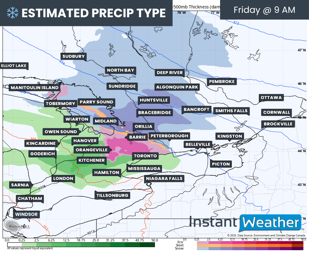
PRECIP TYPE - MAP FROM WEATHERBELL
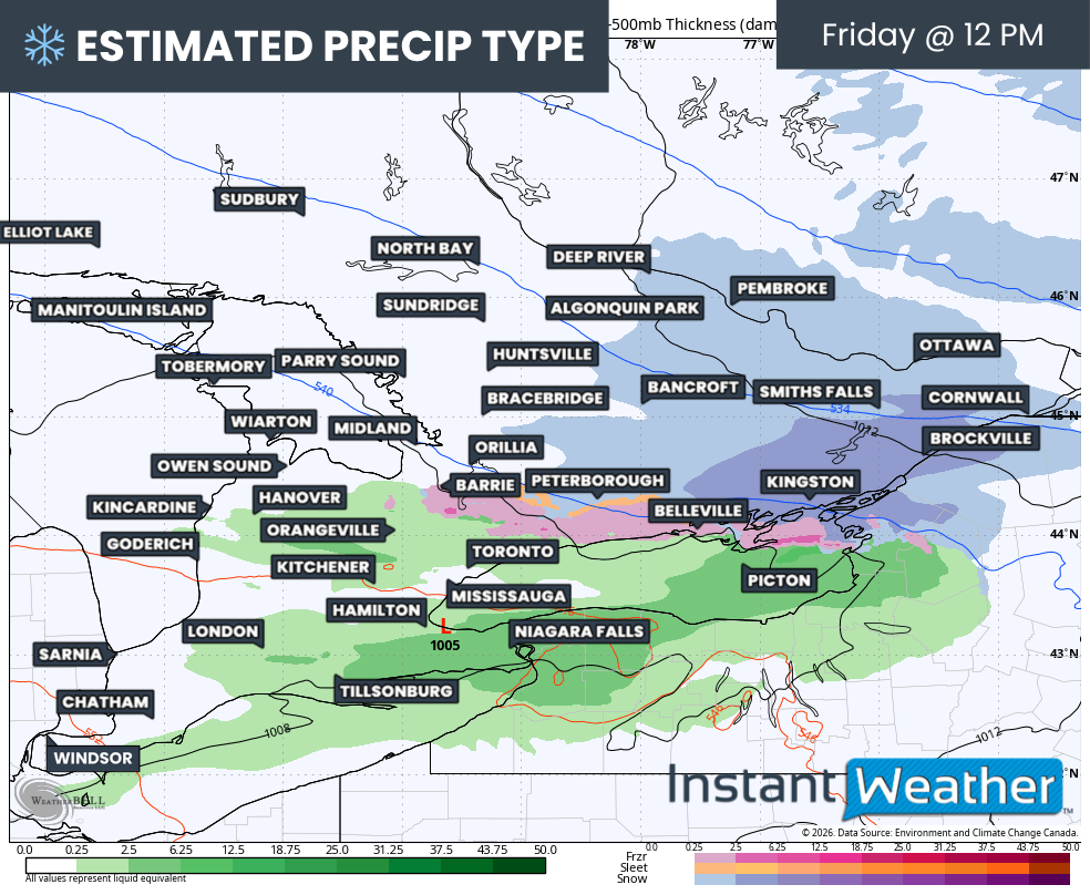
Precipitation is expected to move into Southwestern Ontario around sunrise, then gradually spread eastward into the Golden Horseshoe and Central Ontario by the late morning, roughly between 8 and 10 am. As it arrives, it will encounter a layer of cold air near the surface that will be slow to move out. This will help set up a swath of winter weather, with snow stretching from Muskoka into Eastern Ontario, and a mix of ice pellets and freezing rain developing around Lake Simcoe and into Peterborough.
More persistent freezing rain is likely across higher elevations northwest and north of the Greater Toronto Area. For areas closer to Lake Ontario and outside of the higher terrain, freezing rain will be more limited, generally lasting an hour or two during the mid to late morning before temperatures rise.
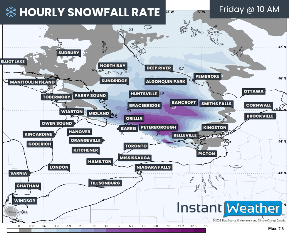
HOURLY SNOWFALL RATE (CM) - MAP FROM WEATHERBELL
The snow band moving through Muskoka, Peterborough, and into Eastern Ontario could be quite intense at times. Snowfall rates may briefly reach 3 to 6 cm per hour late in the morning into the early afternoon. Some of this precipitation may fall as ice pellets, which could reduce overall snow totals slightly.
PRECIP TYPE - MAP FROM WEATHERBELL
As temperatures continue to rise, areas around the Greater Toronto Area should transition to regular rain by around midday. However, a corridor of freezing rain may develop from Barrie through Peterborough and into Kingston. This, combined with slushy snow, could result in very poor road conditions with icy patches.
Precipitation will gradually taper off through the afternoon, with Eastern Ontario likely being the last region to see it come to an end.
TEMPERATURE - MAP FROM WEATHERBELL
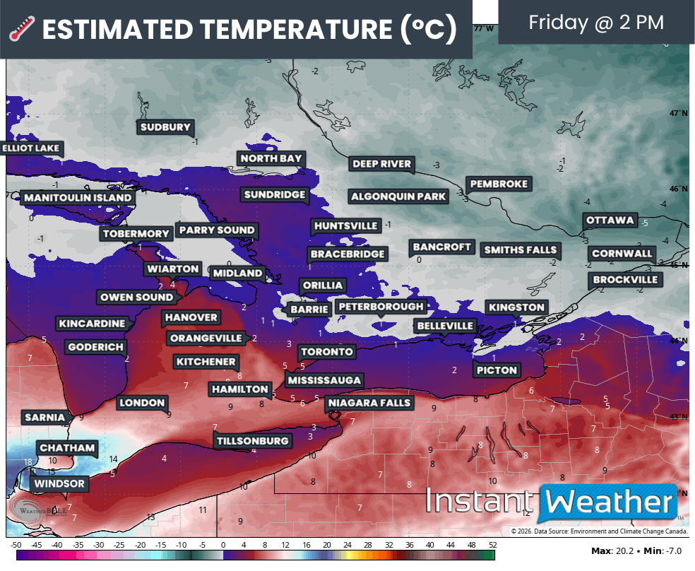
Temperatures will vary significantly across the region on Friday afternoon. Deep Southwestern Ontario, including Windsor, Leamington, and Chatham, could surge well into the double digits and approach 20°C. Meanwhile, Central and Eastern Ontario may struggle to climb above the freezing mark.
The good news is that most areas expecting any notable ice accretion should see temperatures rise above freezing by the afternoon. This will help reduce the overall impact on tree branches and power lines, and also improve road conditions as the day goes on.
NOTE: YOU CAN CLICK ON THE MAP TO OPEN A ZOOMABLE IMAGE

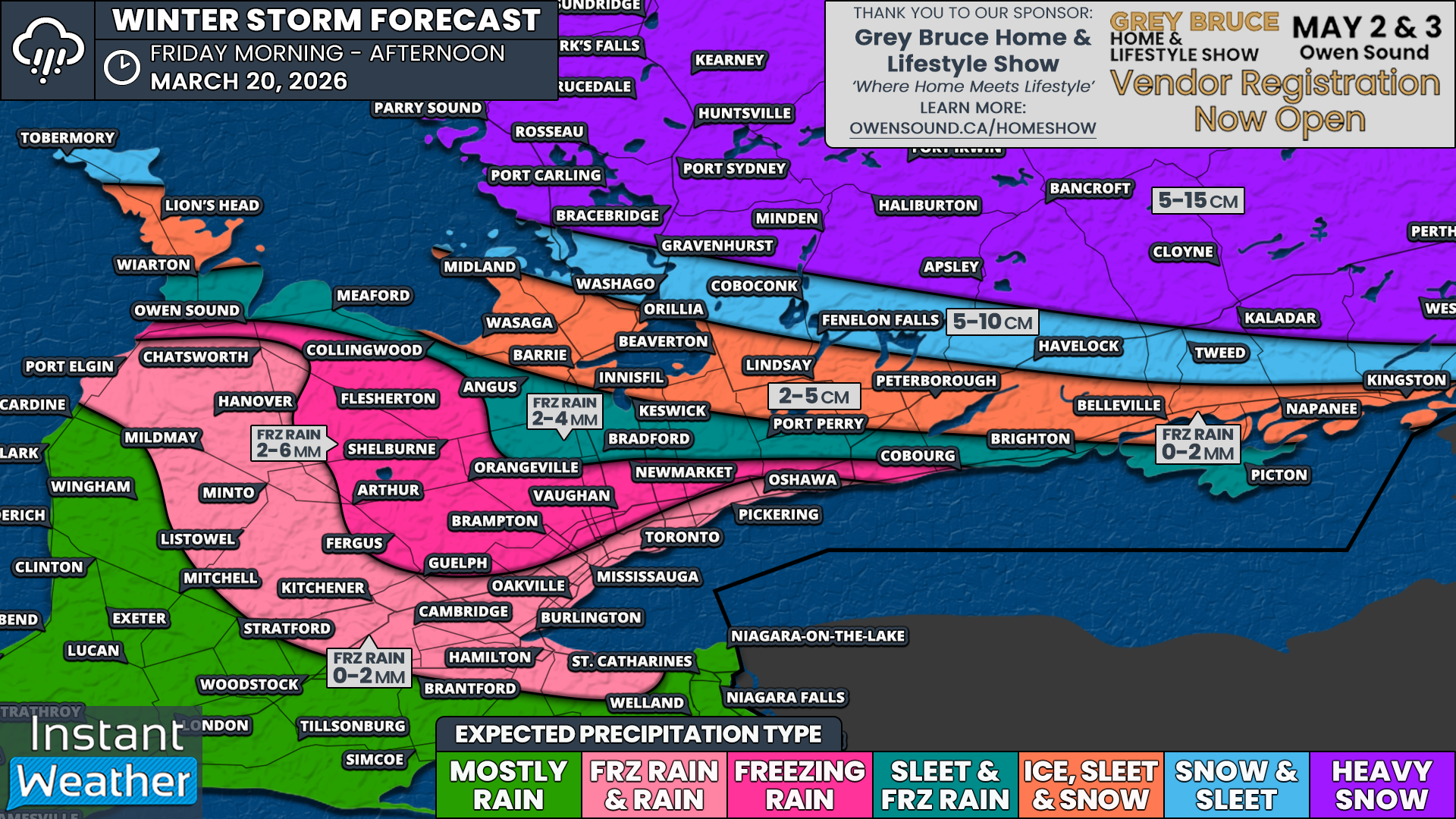
Overall impacts will vary quite a bit depending on location. Across Central and Eastern Ontario, the main story will be heavy snow. Accumulations are expected to range from 5 to 10 cm, with some areas potentially approaching 15 cm. This includes regions north of a line from Gravenhurst to Brockville, including Muskoka, Haliburton, Bancroft, Pembroke, Renfrew, Smiths Falls, Ottawa, and Cornwall.
South of this line, a narrow corridor from Simcoe County through Kawartha Lakes, Peterborough, and into Kingston will likely see a mix of everything. This includes a period of snow, followed by ice pellets, and finishing with some freezing rain. Total accumulation in this zone will range from 2 to 10 cm, with higher amounts toward the northern edge.
The most persistent freezing rain is expected across higher elevations, including areas such as Flesherton, Shelburne, Arthur, Fergus, Guelph, Orangeville, Vaughan, and Newmarket. These areas could see between 2 and 6 mm of ice accretion.
Closer to Lake Simcoe, including northern York Region into Durham Region, around 2 to 4 mm of icing is possible, along with some ice pellets.
Near the Lake Ontario shoreline, including the Greater Toronto Area into Hamilton, Kitchener, Perth, and Grey Bruce, freezing rain is expected to be brief. Most areas will see less than 2 mm of ice, and impacts should be limited as temperatures rise above freezing relatively quickly.
For areas along the Lake Huron and Lake Erie shorelines into Deep Southwestern Ontario, this system will stay primarily on the rain side, with little to no winter precipitation expected.