


Strong Severe Storm Risk Targets Southern Ontario Tuesday With Damaging Winds, Toonie-Sized Hail and Tornadoes Possible
/
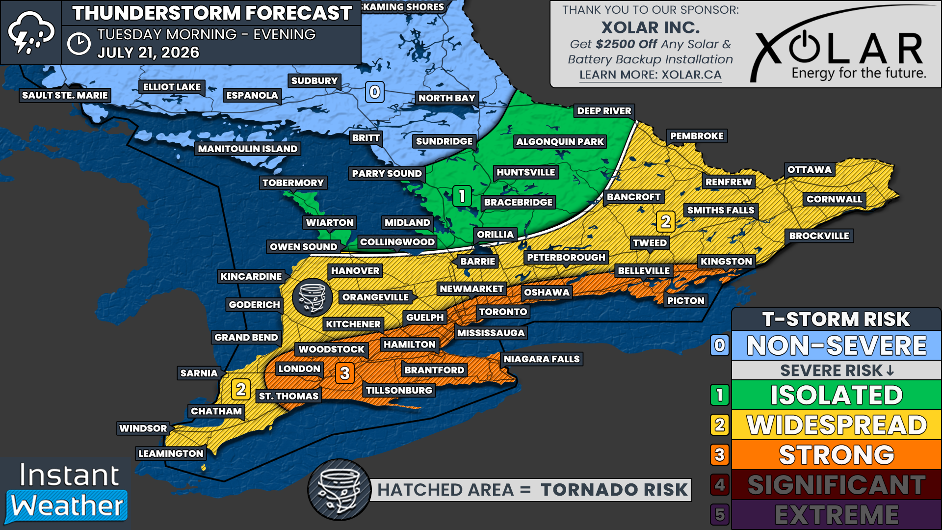
NOTE: YOU CAN CLICK ON THE MAP TO OPEN A ZOOMABLE IMAGE
After an active storm day on Saturday brought a rare tornado warning to the Greater Toronto Area along with several reports of damaging winds, Southern Ontario is set to face another severe thunderstorm threat on Tuesday.
The strongest risk appears to be focused along the Highway 401 corridor, stretching from London through the Greater Toronto Area and into Kingston. Storms during the afternoon and early evening could bring widespread damaging wind gusts, up to toonie-sized hail and one or two tornadoes.
Before the main event, morning storms may provide an early wake-up call for parts of Southwestern Ontario and the Golden Horseshoe as a complex of storms tracks into the region from Michigan during the early morning hours on Tuesday.
While most of these storms should remain non-severe, some stronger pockets could bring marginally severe wind gusts, large hail and even a very low tornado threat.
In the wake of Tuesday’s storm threat, which is expected to end by the evening, a cold front will usher much cooler air into Southern Ontario.
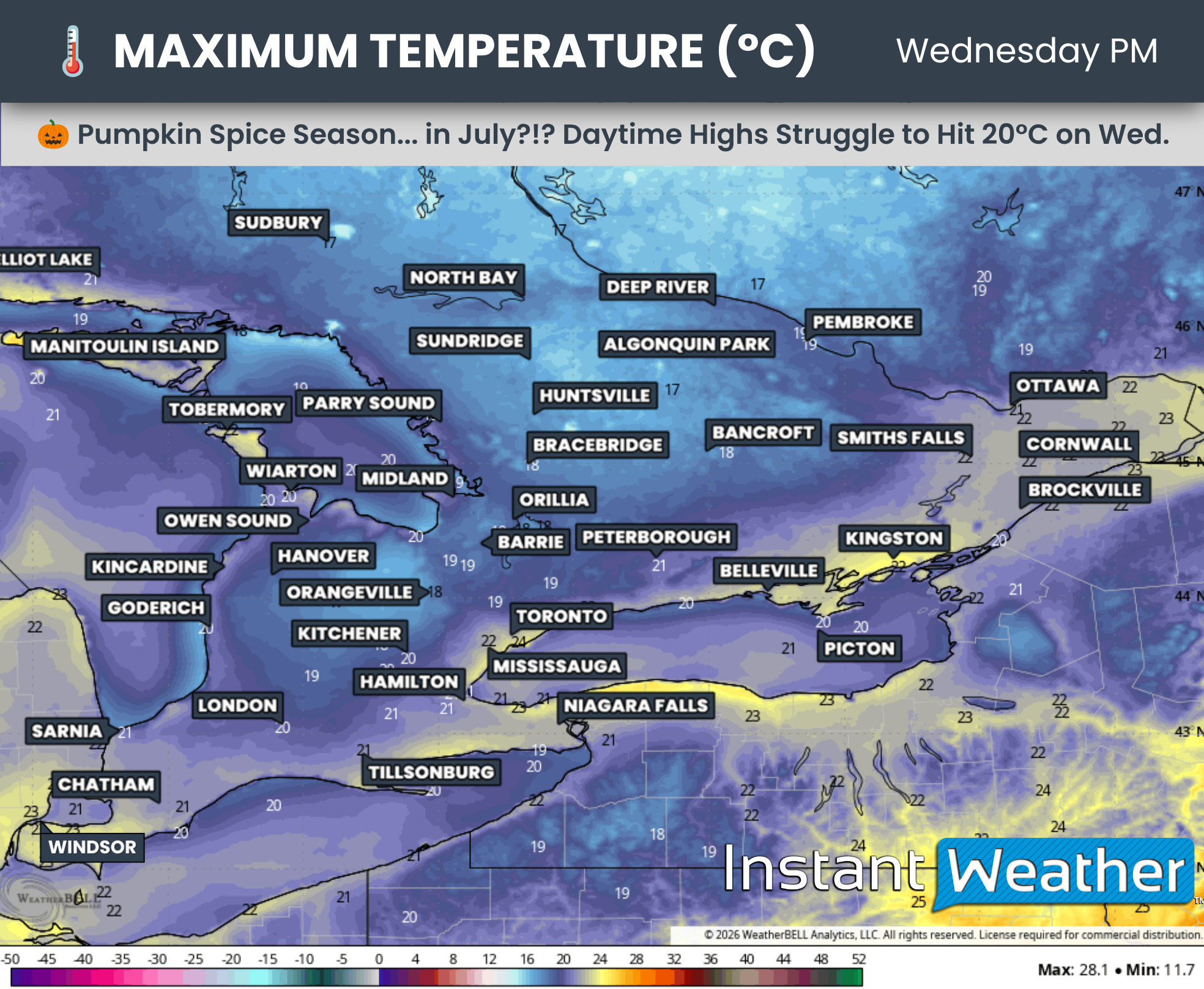
Daytime highs on Wednesday could struggle to reach the 20°C mark, making it feel more like early autumn. You may find yourself reaching for the comfort of a pumpkin spice latte instead of a cold summer refreshment!
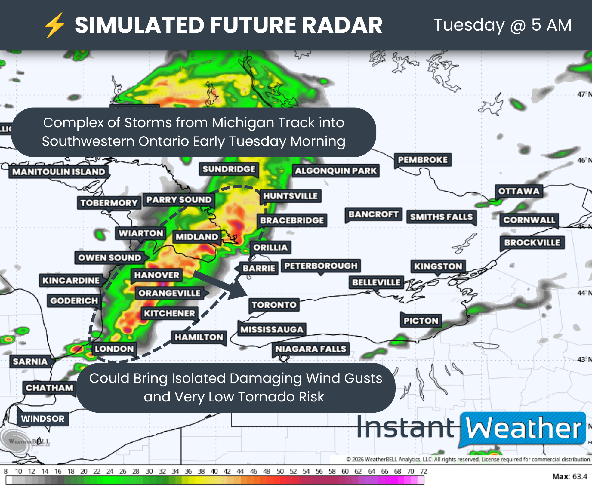
DATA FROM WEATHERBELL
A mesoscale convective system (MCS) over Michigan is expected to slide into Southern Ontario overnight and early Tuesday morning, first affecting areas east of Lake Huron between approximately 1 and 3 a.m.
As the complex moves inland, some stronger pockets could produce wind gusts exceeding 90 km/h and hail up to the size of a quarter.
There is some uncertainty over how strong this storm complex will remain as it tracks eastward into Central Ontario and the Golden Horseshoe between approximately 3 and 6 a.m.
Weather models tend to struggle with these types of systems. They can sometimes generate their own energy and maintain or strengthen themselves in an environment that would otherwise appear unsupportive of severe weather.
A brief spin-up capable of producing an isolated tornado cannot be completely ruled out, although this is considered very unlikely given the overnight timing.
The marginal severe threat associated with this complex could continue into the mid-morning hours as it reaches the Niagara Region and communities along the northern Lake Ontario shoreline.
The morning storms are expected to clear out by late morning, potentially setting the stage for a more widespread and intense severe weather threat beginning early Tuesday afternoon.
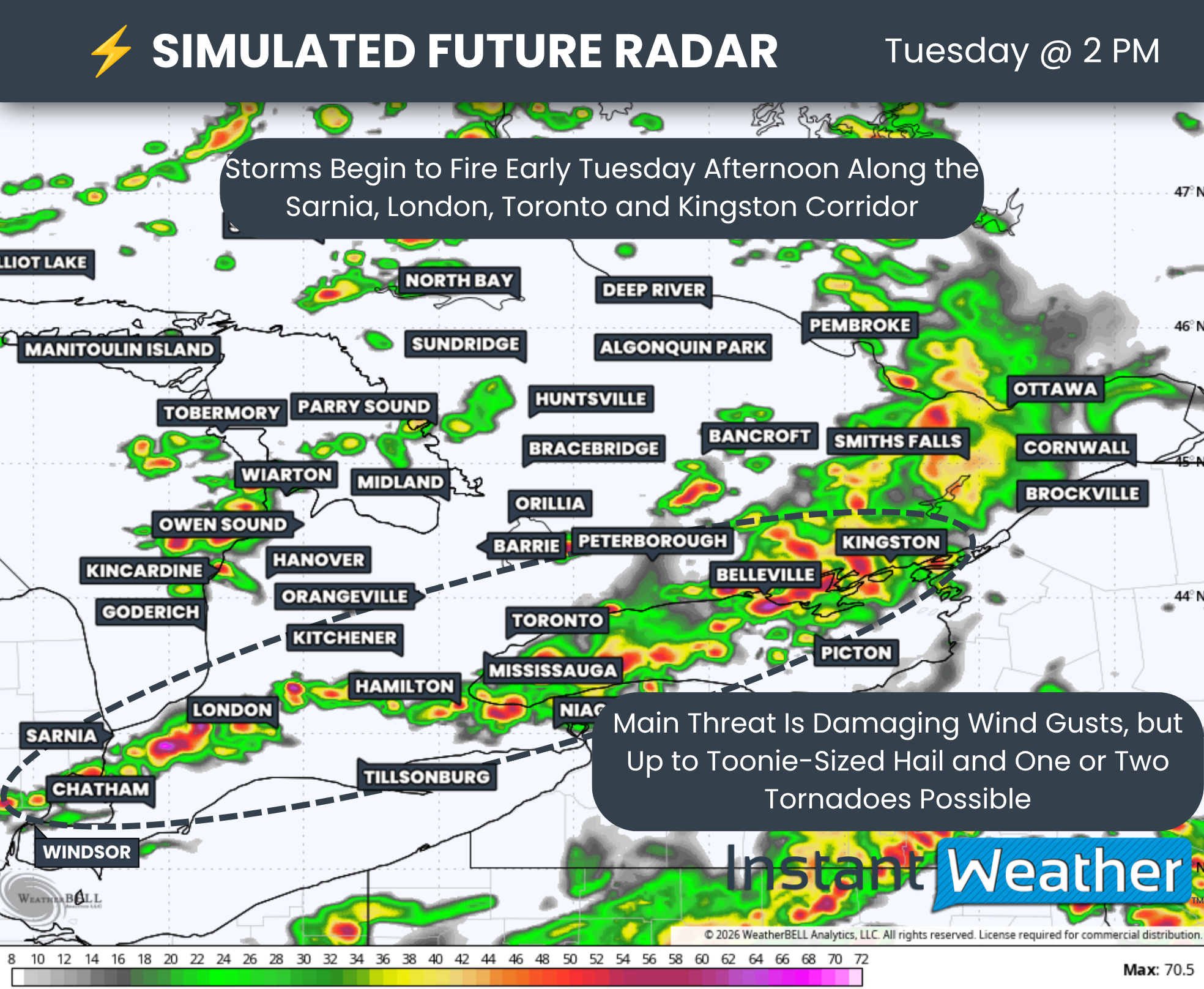
DATA FROM WEATHERBELL
There is still some uncertainty surrounding the timing of the afternoon threat, especially since multiple rounds of storms may be possible.
The afternoon risk will also depend heavily on how quickly the morning storms move out. This will determine how much daytime heating can occur before the next round develops, likely along a cold front moving through the region during the afternoon.
Based on the latest data, the greatest chance for storm development appears to be along a line stretching from Sarnia through London and into the Greater Toronto Area, generally following the Highway 401 corridor.
Storms could begin developing during the early afternoon before tracking southeast toward the Lake Erie and Lake Ontario shorelines. This would bring the threat into Hamilton, the Niagara Region, Prince Edward County and Kingston later in the afternoon.
In addition to the cold front, a warm front will track through Central and Eastern Ontario during the afternoon. This could spark isolated severe storms around Lake Simcoe and into the Ottawa Valley.
However, the strongest environment is expected to develop around the Lake Ontario and Lake Erie shorelines. These areas should experience several hours of daytime heating after the warm front moves through during the morning, adding further instability before the cold front sweeps through later in the day.
The timing of the cold front will be critical. If it moves through too early, substantial storm development may not occur until the front begins moving south of the border, decreasing the risk to our side of the border.
If it is delayed, storms could begin developing farther northwest and have more of Southern Ontario to track across during the peak of daytime heating, potentially increasing the overall severe weather threat.
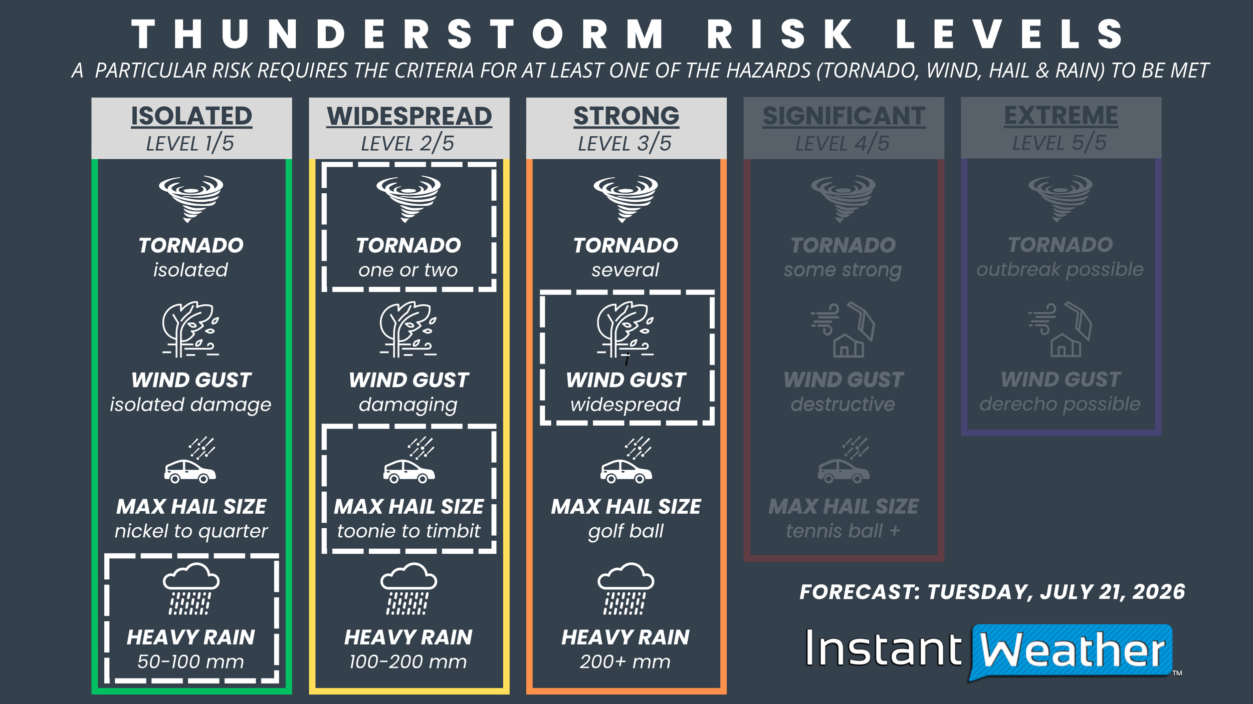
NOTE: YOU CAN CLICK ON THE GRAPHIC TO OPEN A ZOOMABLE IMAGE

Based on the potential for widespread damaging wind gusts, we have introduced a ‘strong’ severe risk for London, St. Thomas, Woodstock, Tillsonburg, Brantford, Kitchener, Hamilton, Niagara, Guelph, Mississauga, Toronto, Newmarket, Oshawa, Belleville, Picton and Kingston.
Other hazards within this zone include hail up to the size of a toonie and the potential for one or two tornadoes.
Localized flash flooding may also be a concern, particularly in urban areas that receive multiple rounds of storms within a short period.
Outside the strongest risk zone, we have an expansive ‘widespread’ risk covering the remainder of Southwestern Ontario, southern portions of Central Ontario and the Ottawa Valley.
This includes Windsor, Chatham, Sarnia, Goderich, Hanover, Orangeville, Barrie, Peterborough, Bancroft, Pembroke, Renfrew, Smiths Falls, Ottawa, Brockville and Cornwall.
Storm hazards in this zone include damaging wind gusts, hail up to the size of a toonie and the possibility of an isolated tornado.
For the Bruce Peninsula and areas east of Georgian Bay, including Muskoka and Algonquin Park, we have introduced an ‘isolated’ severe risk. However, most of the severe thunderstorm activity is expected to remain south and east of this region.
DATA FROM WEATHERBELL
After a second cold front moves through late Tuesday evening, it will usher in a much fresher air mass across Southern Ontario.
Morning temperatures on Wednesday could fall into the upper single digits across some of the more elevated portions of Central Ontario.
It may continue to feel like pumpkin spice season throughout Wednesday, with daytime highs in many areas struggling to climb above 20°C.
Deep Southwestern Ontario, communities along the Lake Ontario shoreline and parts of Eastern Ontario currently have the best chance of reaching the low 20s on Wednesday.
The coldest conditions will be found across the higher elevations of the Dundalk Highlands and into cottage country, where daytime highs on Wednesday could remain in the upper teens.
Those temperatures would be more typical of a crisp autumn day in early September than the middle of summer!
Thankfully, the cooldown should be short-lived, with more seasonal temperatures expected to return by the end of the week and into the weekend.



