


Ottawa Valley and Central Ontario Face Tornado and Large Hail Risk Monday as Wildfire Smoke Adds Uncertainty to Storm Threat for Southwestern Ontario
/
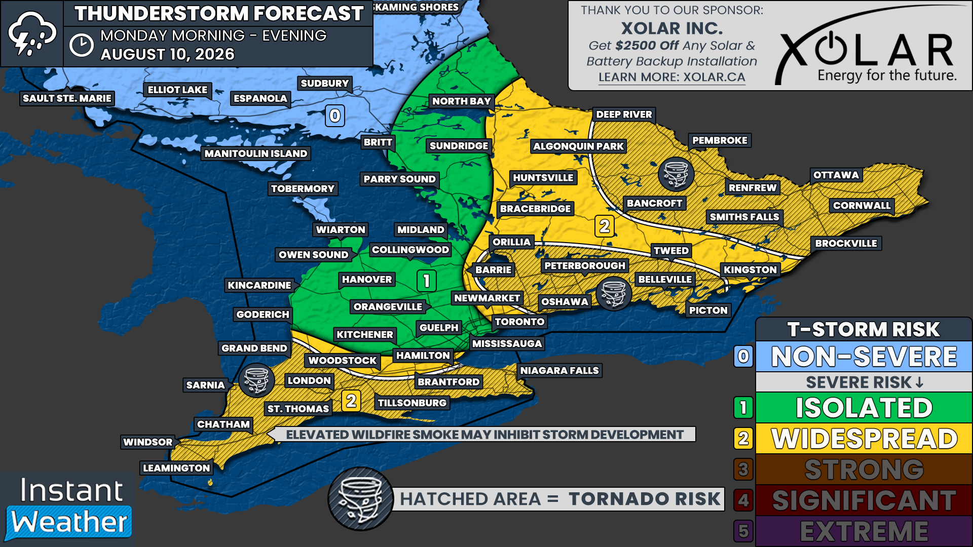
NOTE: YOU CAN CLICK ON THE MAP TO OPEN A ZOOMABLE IMAGE
After at least two tornadoes were confirmed to have touched down in Southern Ontario on Saturday, the risk of active weather will continue into the start of the week.
A complex, multi-wave severe weather threat is expected to unfold across Southern Ontario on Monday, including in some of the areas that experienced the worst storms on Saturday.
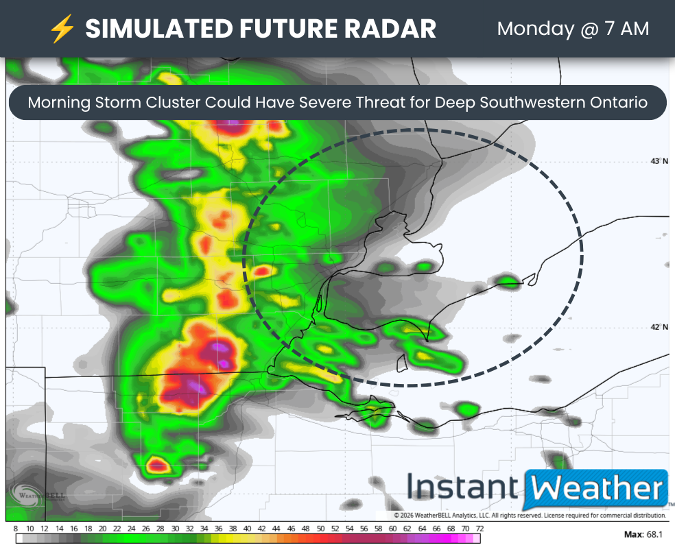
The first round will begin with a complex of storms moving across Michigan and potentially crossing the border into Deep Southwestern Ontario around sunrise.
There is some uncertainty about how strong these storms will be since there will not be any daytime heating to fuel them. However, the environment could still be supportive enough for the storms to reach near-severe or severe levels.
Join Us on YouTube for Storm Coverage:
We'll be providing comprehensive live coverage of any storms that develop Monday on our YouTube channel. Our team will be tracking storms in real time with live radar analysis, warnings, and storm reports, so if severe weather threatens your area, be sure to join us live to help stay informed.
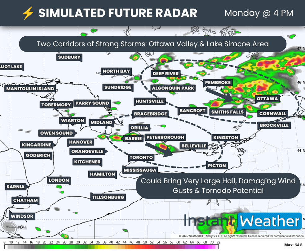
The strongest severe weather threat could take shape during the early afternoon as isolated cells begin to develop across Central Ontario and track into the Ottawa Valley.
Another corridor of storms may develop around Lake Simcoe before tracking through the Kawartha Lakes and into the Peterborough and Belleville areas.
These storms could produce all severe weather hazards, including hail up to the size of Timbits, with locally larger hail approaching golf ball size. Damaging wind gusts and an isolated tornado will also be possible.
Another round of storms could develop during the late afternoon and early evening across Deep Southwestern Ontario and into the Niagara Region.
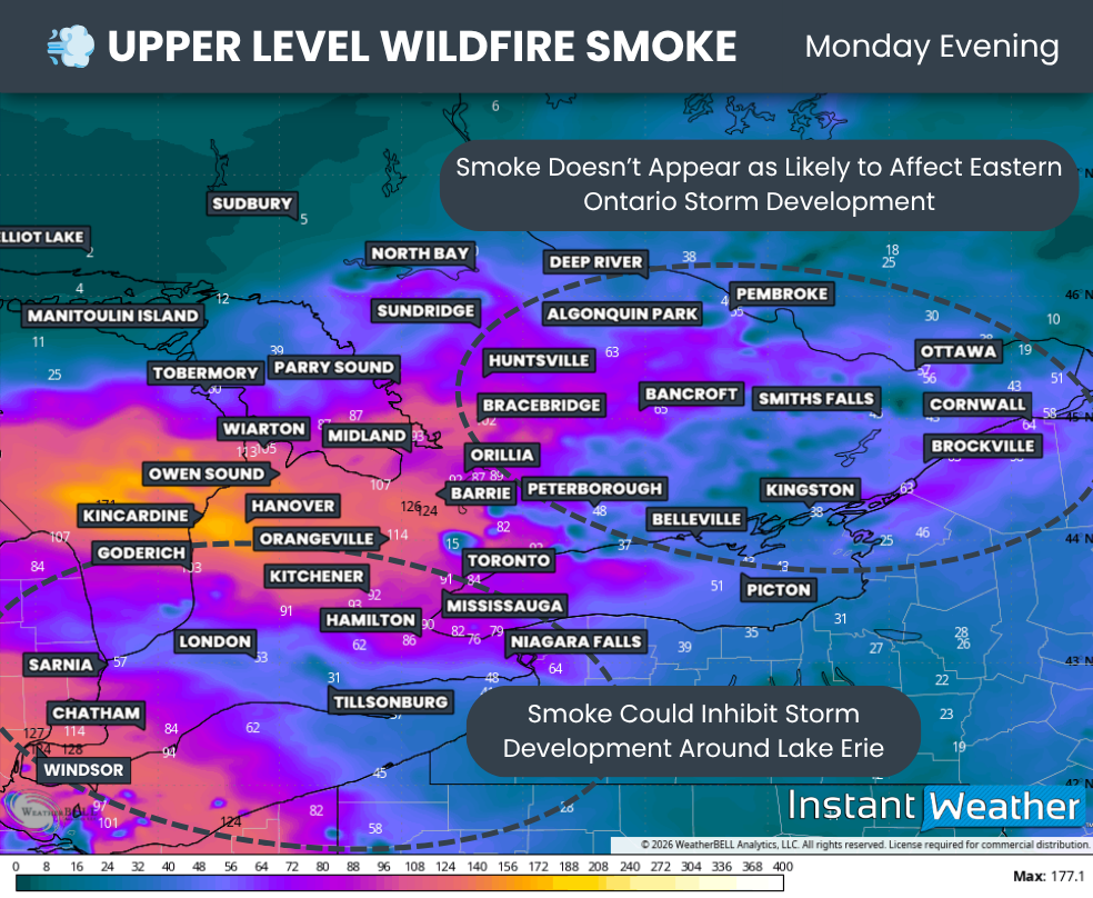
However, wildfire smoke from Western Canada is expected to move into Southwestern Ontario during the late afternoon.
The smoke should remain elevated high in the atmosphere, so impacts at ground level are expected to be limited. However, as we have seen in the past, elevated wildfire smoke can reduce daytime heating and inhibit thunderstorm development.
DATA FROM WEATHERBELL
A strong complex of storms is expected to move across Lower Michigan during the pre-dawn hours on Monday.
Based on the latest data, these storms could reach the Canadian border sometime between 6 and 8 a.m.
There is still some uncertainty about how strong the storms will be by the time they track into Deep Southwestern Ontario.
However, the environment could support damaging wind gusts, particularly around Essex County. Isolated large hail up to the size of toonies will also be possible.
DATA FROM WEATHERBELL
By the early afternoon, attention will turn to two main corridors where thunderstorm development appears most likely.
The most prolific storms are expected to form around Algonquin Park before tracking through Pembroke, Renfrew and into the Ottawa region.
These storms could produce large hail, damaging wind gusts and an isolated tornado.
Another area where isolated storms may develop includes the Lindsay area, where one of Saturday’s confirmed tornadoes occurred.
Storms are once again expected to form around Lake Simcoe before slowly tracking through the Kawartha Lakes, Peterborough and Belleville corridor.
Large hail will likely be the primary threat in this area, but damaging wind gusts and an isolated tornado cannot be ruled out.
DATA FROM WEATHERBELL
However, a familiar theme this year could throw a wrench into yet another severe weather threat, and that is wildfire smoke.
This time, the smoke will originate from the West Coast. It is expected to remain mostly elevated in the upper levels of the atmosphere, meaning significant impacts on air quality are not anticipated.
What the smoke can do, however, is act like a blanket over the region. This could reduce daytime heating and make it more difficult for thunderstorms to develop.
Based on the latest data, the smoke should be less of an issue across the Central Ontario and Ottawa Valley corridor.
This means those areas are less likely to experience a smoke-driven bust, although that possibility cannot be completely ruled out.
Thicker smoke across Southwestern Ontario could have a greater impact on thunderstorm development, despite the presence of an otherwise fairly strong severe weather environment.
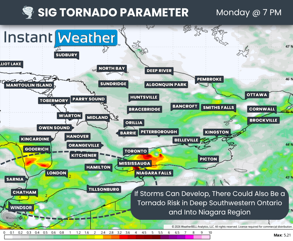
DATA FROM WEATHERBELL
The significant tornado parameter provides an overview of where the atmospheric environment could support tornadoes if a storm develops in a particular area.
Current data shows a somewhat favourable environment across Deep Southwestern Ontario, extending into portions of the western Greater Toronto Area and the Niagara Region during the late afternoon and early evening.
However, as mentioned above, thunderstorm development in this area remains highly uncertain because of the expected presence of wildfire smoke.
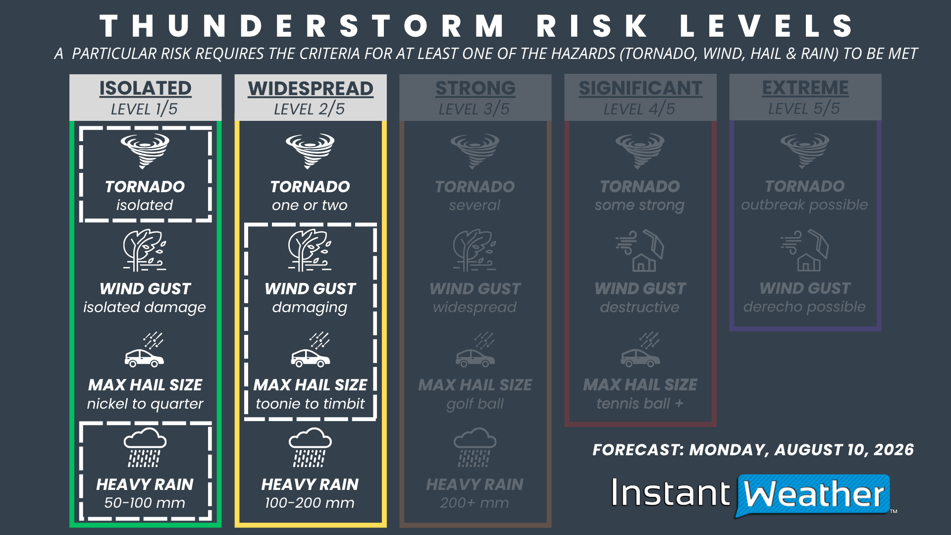
NOTE: YOU CAN CLICK ON THE GRAPHIC TO OPEN A ZOOMABLE IMAGE

For now, we are maintaining a widespread severe risk as the highest threat level in this forecast.
We may consider upgrading parts of the region to a strong risk if confidence increases that the wildfire smoke will not significantly affect thunderstorm development.
The widespread severe risk includes Ottawa, Cornwall, Brockville, Smiths Falls, Renfrew, Bancroft, Kingston, Belleville, Pembroke, Algonquin Park, Peterborough, Oshawa, Newmarket, Barrie, Orillia, Bracebridge and Huntsville.
The main hazards include localized damaging hail up to golf ball size, although most hailstones are expected to range from quarter to toonie size. Damaging wind gusts will also be possible.
An isolated tornado cannot be ruled out, particularly through the Ottawa Valley and in areas east of Lake Simcoe.
A conditional widespread severe risk covers Deep Southwestern Ontario and extends along the Lake Erie shoreline into the Niagara Region.
This risk depends on the wildfire smoke holding off or having less of an impact later in the day, allowing the atmosphere to become unstable enough for thunderstorms to develop.
If storms can form, the environment could support all severe weather hazards, including hail up to the size of Timbits, damaging wind gusts and an isolated tornado.
Elsewhere across Southern Ontario, isolated thunderstorms could produce damaging wind gusts and hail up to the size of quarters.
Localized flooding may also become an issue with any of these storms, as some could move slowly or repeatedly track over the same area for several hours.



