


Potential Tornado Risk for Greater Toronto Area and Southwestern Ontario With Severe Storms Wednesday
/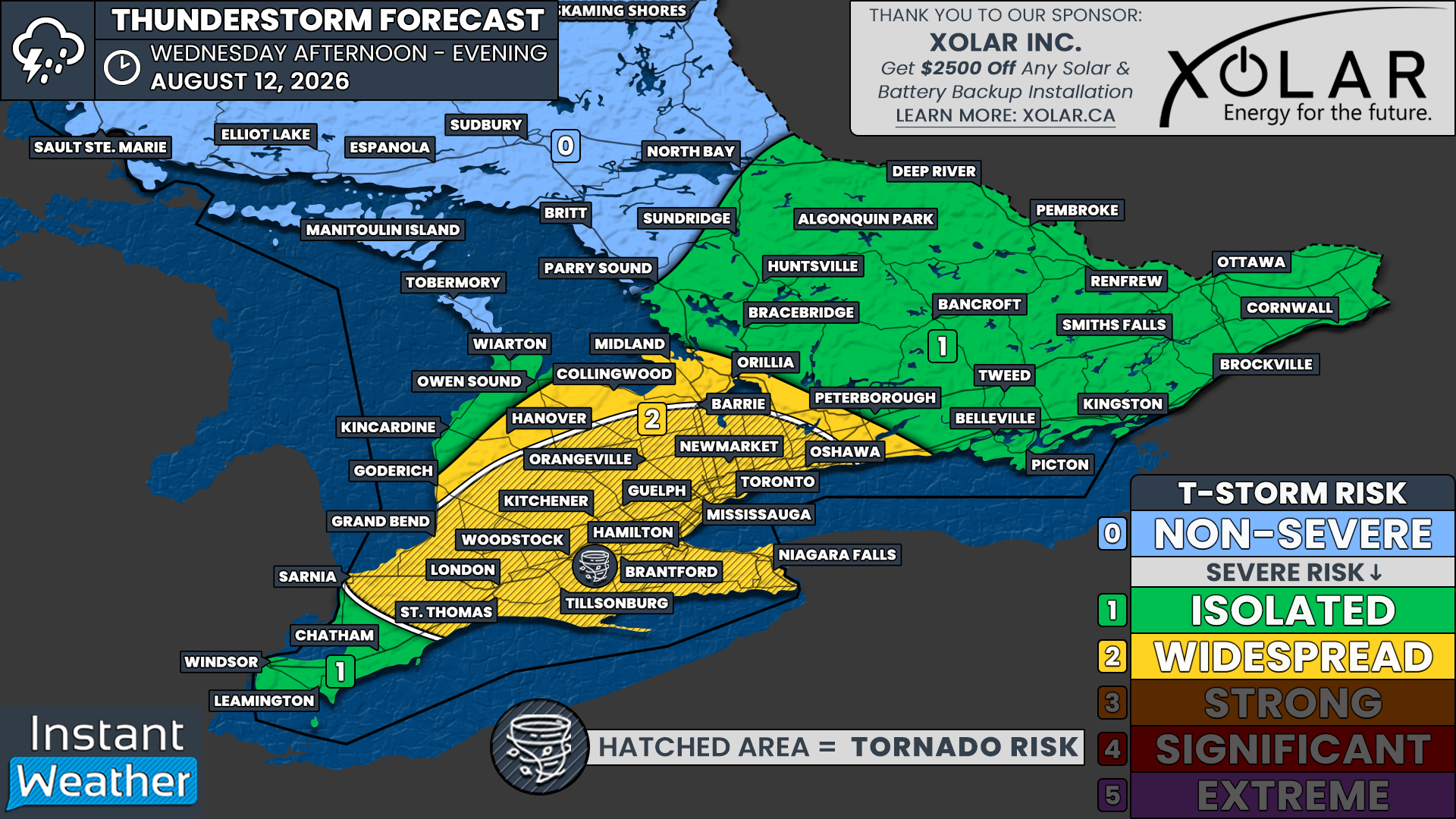
NOTE: YOU CAN CLICK ON THE MAP TO OPEN A ZOOMABLE IMAGE

Another storm threat is on the horizon for Southern Ontario this week, with widespread severe weather potential expected across a large portion of Southwestern Ontario and into the Golden Horseshoe on Wednesday.
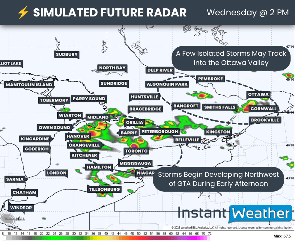
A cluster of thunderstorms is expected to develop during the early afternoon to the northwest of the Greater Toronto Area before gradually tracking southeastward through the afternoon.
These storms will have the potential to produce all severe hazards, including damaging wind gusts, up to Timbit-sized hail, and an isolated tornado. Some stronger cells could even produce locally up to golf ball-sized hail, particularly closer to the Lake Ontario shoreline.
Join Us on YouTube for Storm Coverage:
We'll be providing comprehensive live coverage of any storms that develop on Wednesday on our YouTube channel. Our team will be tracking storms in real time with live radar analysis, warnings, and storm reports, so if severe weather threatens your area, be sure to join us live to help stay informed.
Flooding will also be a concern, as there are some indications that these storms could be fairly slow-moving and potentially regenerate over the same areas for several hours.
This will be especially important to watch in urban areas such as the Greater Toronto Area, as well as the Niagara Region, which has already been hit hard by flooding over the past few weeks. Any locations that receive repeated thunderstorms could quickly pick up significant rainfall over a short period of time.
As for the tornado risk, the latest data has been particularly focused on the western GTA through Hamilton and into portions of the Niagara Region during the mid to late afternoon hours.
The tornado threat isn't particularly strong, but the consistency in the latest data is noteworthy. We can't rule out a brief tornado somewhere around the Lake Ontario shoreline as storms move through the region.
A tornado risk may also extend farther west into Southwestern Ontario, including around Kitchener and London. However, this threat is less certain because storm development becomes more questionable farther west.
We could also see some isolated thunderstorms develop across Central Ontario and track into portions of the Ottawa Valley.
The severe threat doesn't appear to be as widespread in this region compared to Southwestern Ontario and the Golden Horseshoe. However, a few stronger storms capable of producing large hail and damaging wind gusts will still be possible.
Most of the thunderstorm activity is expected to gradually wind down during the early evening as we lose the daytime heating that will help fuel these storms.
DATA FROM WEATHERBELL
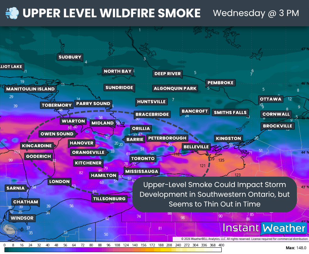
One factor that could throw a wrench into Wednesday's severe weather setup is wildfire smoke.
As we've seen with a few previous storm threats, including on Monday when smoke contributed to part of the severe risk busting across Southwestern Ontario, wildfire smoke can have a significant impact on how much instability is able to build.
Models show some fairly thick upper-level wildfire smoke covering much of Southwestern Ontario and the Golden Horseshoe on Wednesday morning.
However, the latest data suggests that the smoke should begin to thin somewhat around or shortly after the noon hour. If that happens as expected, there should still be enough daytime heating to allow the atmosphere to destabilize and thunderstorms to develop.
If the smoke hangs around longer or is thicker than expected, storms could struggle to develop and take advantage of the otherwise favourable environment.
At this point, that bust potential appears fairly low, but it can't be completely taken off the table.
DATA FROM WEATHERBELL
Based on the latest model data, there appear to be two main corridors where thunderstorm development could begin sometime between approximately 12 and 2 PM across Southern Ontario.
The first area is around the southern Georgian Bay shoreline, extending southeastward into the Lake Simcoe region.
Isolated thunderstorms are expected to develop in this area before quickly strengthening as they slowly track southeastward toward Lake Ontario and the Greater Toronto Area.
Given the environment in place, any storm that can remain isolated could quickly become severe, with large hail and damaging wind gusts being the main threats initially.
The second area of potential development extends from Algonquin Park into the Ottawa Valley, where a few isolated thunderstorms may begin to pop up during the early afternoon.
It remains unclear whether these storms will become organized enough to produce widespread severe weather. However, locally large hail and damaging wind gusts can't be ruled out with any stronger cells that develop.
DATA FROM WEATHERBELL
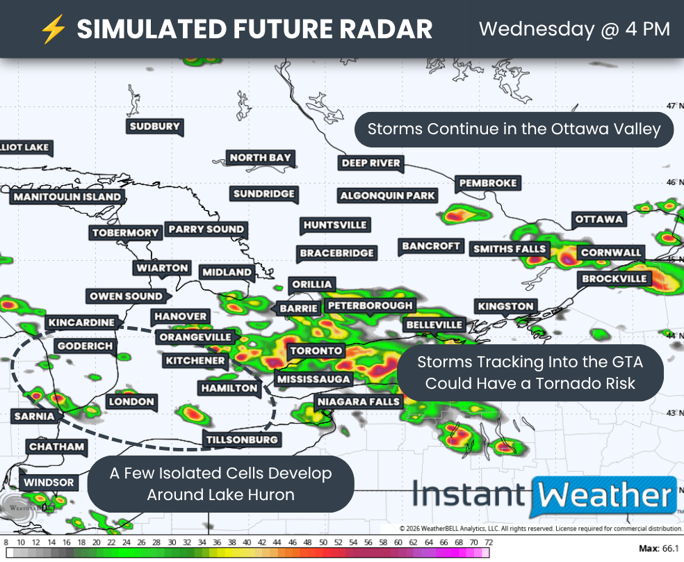
By the middle of the afternoon, another area could enter the picture around the southeastern Lake Huron shoreline as isolated thunderstorms potentially begin to develop.
Storm development in this area is more questionable, and not every model shows storms forming. However, any thunderstorms that do develop will have a favourable environment to work with around Sarnia, London and Goderich.
These storms could produce up to toonie-sized hail along with damaging wind gusts. An isolated tornado risk also can't be ruled out, particularly if storms are able to remain discrete as they mature and move inland from the Lake Huron shoreline.
The most notable tornado threat appears to develop as the earlier storms track into the Greater Toronto Area sometime between approximately 3 and 5 PM. The storms are then expected to continue southeastward into Hamilton and the Niagara Region between approximately 4 and 6 PM.
Models have been fairly consistent in highlighting this corridor as having the strongest tornado potential on Wednesday. However, one factor that could reduce the tornado threat is storm mode.
Some models show the individual thunderstorms gradually merging into a larger cluster as they move into the Golden Horseshoe. If this happens, a more linear storm structure would likely reduce the tornado and very large hail threat, while increasing the focus on damaging wind gusts and heavy rainfall.
If the storms can remain more isolated, there is a chance we could see a few supercells move through portions of the Golden Horseshoe.
Those stronger storms could produce Timbit to golf ball-sized hail, damaging wind gusts and an isolated tornado.
Farther east, isolated thunderstorms may continue to affect the Ottawa Valley through the late afternoon.
While the severe threat is more isolated compared to the Golden Horseshoe, some stronger cells could still produce locally large hail, damaging wind gusts and torrential rainfall.
This activity should gradually weaken shortly after the dinner hour as instability begins to decrease.
Across Southwestern Ontario and the Greater Toronto Area, thunderstorms are expected to slowly track southeastward toward Lake Erie and Lake Ontario through the late afternoon and early evening.
Storms should then gradually weaken as they move south of the border and daylight begins to fade.
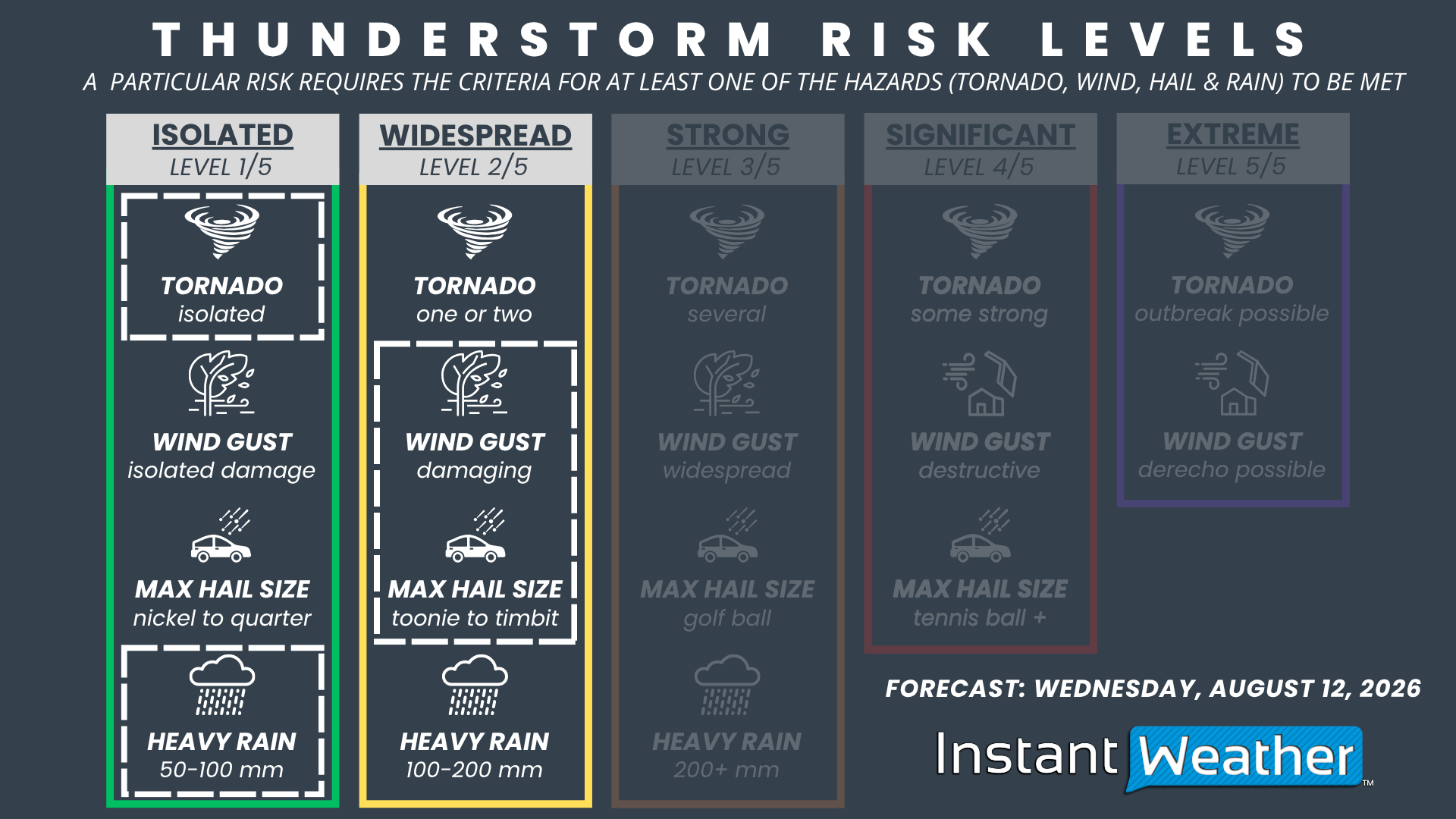
NOTE: YOU CAN CLICK ON THE GRAPHIC TO OPEN A ZOOMABLE IMAGE

For now, our maximum severe threat for Wednesday is a widespread (level 2/5) risk covering a large portion of Southwestern Ontario and the Golden Horseshoe.
There is a chance we may introduce a strong (level 3/5) risk around parts of the Golden Horseshoe if Wednesday morning's data continues to strengthen the signal for large hail, damaging wind gusts and an isolated tornado.
The widespread risk currently includes Toronto, Mississauga, Hamilton, Niagara Falls, Brantford, Tillsonburg, Woodstock, London, St. Thomas, Sarnia, Grand Bend, Goderich, Kitchener, Guelph, Orangeville, Hanover, Collingwood, Barrie, Orillia, Newmarket and Oshawa.
Storms within this region will have the potential to produce damaging wind gusts in excess of 100 km/h, large hail up to Timbit-sized, and an isolated tornado.
Locally larger hail approaching golf ball size could be possible with the strongest storms, particularly around the Lake Ontario shoreline if storms are able to remain isolated.
The rest of Southern Ontario, including Deep Southwestern Ontario and portions of Central and Eastern Ontario, is under an isolated severe risk for Wednesday.
Storms in these areas could produce marginally severe hazards, including up to quarter-sized hail, locally approaching toonie size, isolated damaging wind gusts in excess of 90 km/h and heavy rainfall.
As always with summertime thunderstorm risks, not everyone will see severe weather. However, those who do get caught under one of the stronger storms could experience significant conditions over a short period of time.
We'll be closely monitoring the latest data and any changes caused by wildfire smoke Wednesday morning, as even a small change in available instability could have a major impact on where storms develop and how strong they become.



